This document provides an introduction to a book titled "Water Scarcity, Security and Democracy: a Mediterranean Mosaic". It discusses how water has always been a scarce yet vital resource in the Mediterranean region, shaping landscapes and societies. Ancient civilizations in the region centered around rivers, springs, and wells, which played an important cultural and social role. While water was sacred, its scarcity also led to conflicts and was used as a weapon of war. Early laws like Hammurabi's Code aimed to regulate water allocation and prevent theft or negligence. The introduction notes how population growth, climate change, and unsustainable consumption patterns are exacerbating water challenges in the region. It argues sustainable solutions require understanding water's cultural significance and changing social


![35
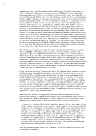
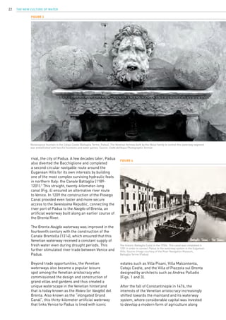
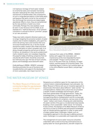
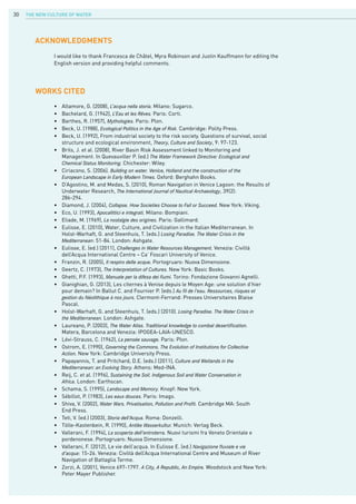
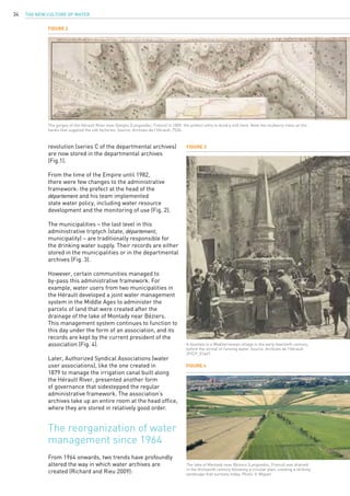
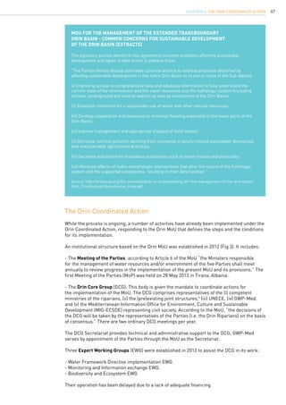
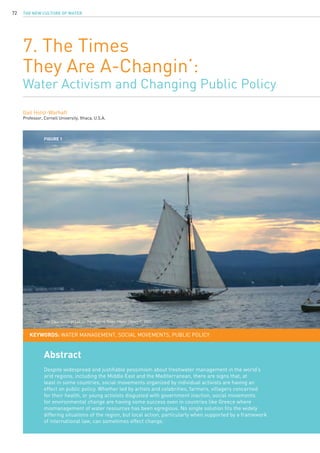
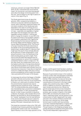
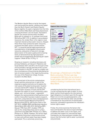
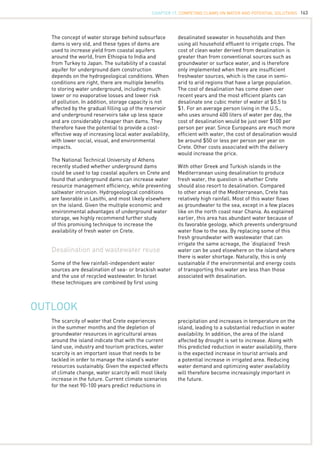
Figure 5
From the late nineteenth century, the irrigation canals on the banks of the Hérault River are managed by a water-user association. Source: Archives
de l’Hérault, 5K 383.
A large variety of organizations are involved
in the collection of historic water documents so
that the literature surrounding water history is
scattered.
These new institutions have unstructured archival
systems, with little to no organized services, no
trained staff, and no classification system. As a
result, documents are more difficult to access.
Researchers and water historians who are used
to finding all documentary resources grouped
together in the national or departmental archive
centers must not overlook the numerous other
sources of documentation. New forms of access
to information are also taking shape with the
online publication of digital resources, which will
allow much broader access and sharing of data,
even beyond the organizational structures of
individual countries.
Translation: Francesca de Châtel
• Richard, S. and Rieu, T. (2009), Vers une gouvernance locale de l’eau en France: analyse
d’une recomposition de l’action publique […], VertigO, 9(1).
• Balsamo, I. et al. (2011), Archives et territories. Paris: Ministère de la Culture, Inspection
des patrimonies.
WORKs CITED
endnotes
1. Pre-revolutionary France was made up of about twenty provinces, which emanated from
the medieval principalities vested in the Crown. With the Revolution, these provinces were
broken up into 89 départements, based on the principle of local administration and gov-
erned by a representative of the state.
On the one hand, the introduction in 1964
of the basin concept and the new approach to
water management it entails. Multi-stakeholder
water management structures are created in
the framework of these basins, known as CLE
or local water commissions made up of state
representatives, local elected representatives,
and users (1992 water law).
On the other hand, in 1982, certain
responsibilities that previously lay with the state
were transferred to the local authorities with the
decentralization laws. Thus the region gradually
replaces the département as the main state
representative.
This has far-reaching consequences for water
management records (Balsamo et al. 2011):
The departmental archives are no longer the
only source of archival production in the area.
CHAPTER 2. Water Archives, a History of Sources](https://image.slidesharecdn.com/c7d6d63b-ab90-42fb-bae8-0d3804f58933-150303061432-conversion-gate01/85/20140925-GWP-MED-PUBLICATION-ONLINE-37-320.jpg)
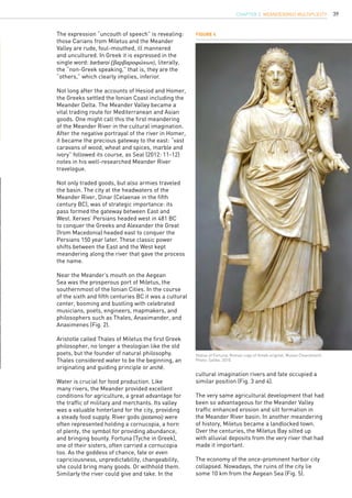
![43
The Meander confounded early lawyers concerned
with boundaries and scientists concerned with the
mechanisms of meandering streams. Meander
symbolized irregularity, complexity, ambiguity,
and instability. In the latter part of the twentieth
century precisely these ‘meandering’ qualities
brought out the value of multiple perspectives in
arts and sciences; the weak ontology of becoming
became as valuable as the traditionally more
privileged strong ontology of being; the inductive,
analogical, and emergent as valuable as control
and generalizability (O’Connor and Copeland
2003: 99). The understanding of probability and
complexity provided new forms of explanation
and new ways to operate even within fields long
founded on ‘ideal’ characteristics and laws.
The meander came to be seen as an irregular
waveform, at once subject to and generating
random processes and forms.
Similarly, recent writers have begun to
characterize emergent and analogical thinking.
These characterizations of ingenuity bear deep
resemblance to the mêtis of antiquity. Dreyfus
speaks of expertise in terms of “intuition [that]
Meandering through
solution space
the nature of his cunning, or of the skills of a
craftsperson, the problem-solving of a detective,
the art of making a good joke, even the “Eureka
moment,” went largely unexamined for centuries.
Mêtis, often defined tersely as “craft, skill, and
experiential wisdom” came to stand for knowing
how, for the palette of abilities outside the logical,
goal-directed, static ways of knowing of logos.
Mêtis escapes simple definition – it “always
appears more or less below the surface,
immersed as it were in practical operations”
(Ibid.: 3). Its way of knowing, its kind of
intelligence and “its field of application is
the world of movement, of multiplicity and of
ambiguity. It bears on fluid situations which are
constantly changing and which at every moment
combine contrary features and forces that are
opposed to each other” (Ibid.: 20).
“The essential features of mêtis … – pliability
and polymorphism, duplicity and equivocality,
inversion and reversal – imply certain qualities
which are also attributed to the curve, to what
is pliable and twisted, to what is oblique and
ambiguous as opposed to what is straight, direct,
rigid and equivocal” (Ibid.: 46). Detienne and
Vernant mention explicitly the term skoliós in
this context, as one of the adjectives indicating
curving, frequently used to describe mêtis; the
same term Strabo used to describe meandering.
is the product of deep situational involvement
and recognition of similarity” and notes: “how
experience-based holistic recognition of similarity
produces deep situational understanding” (1986:
29, 32). Similar concepts characterize modern
ingenuity and engineering design: explicitly
pragmatic; contingent; visual in character;
satisficing; messy; holistic; whimsical; learning
from failure (O’Connor and Copeland 2003:104).
Hapgood describes the first phase of engineering
design as a “metaphorical traversal through
solution space,” in which “failure, imagination,
and stuckness” are at play. The traversal and
design process is “idiographic and unpredictable”
and often beset with “painful trials or iterations.”
For Hapgood the engineer is a “tinkerer who
engages in activities within an artistic and
subjective context” (Hapgood 1993: 96). O’Connor
and Wyatt use the term “thinkering” to blend
Hapgood’s tinkering together with Dreyfus’s
deep situational involvement into “engineering
discovery by doing” (O’Connor and Wyatt 2004:
12).
“Allowing the mind to wander aids creativity,”
asserts science journalist Kaplan in his report
on recent research by psychologists Baird and
Schooler. Their study suggests that “simply taking
a break does not bring on inspiration – rather,
creativity is fostered by tasks that allow the mind
to wander” (Kaplan 2012).
So we see mêtis acknowledged as a set of
habits of expertise and the Meander holding its
metaphorical power for today.
Conclusion:
Re-meandering
In, a so-called “feat of reverse-engineering” a
research team at the University of California
at Berkeley built a scale model of a living
meandering gravel-bed river in their lab. It
was the first successful model ever. A National
Science Foundation report notes: “Stream
restoration is an extremely complex and
delicate science. Because there is no formula
to create meandering streams. Successful
stream restorers almost require a sixth sense
to get everything right and set a sustainable
environment into motion, and not every restored
stream lasts” (Deretsky 2009).
Re-meandering has become a popular practice in
ecological restoration, even in places where there
never were meanders. Rivers are resurfacing in
the public imagination as cultural and ecological
corridors, creating a cultural rejuvenation
around urban renewal projects. In many rural
CHAPTER 3. Meander(ing) Multiplicity](https://image.slidesharecdn.com/c7d6d63b-ab90-42fb-bae8-0d3804f58933-150303061432-conversion-gate01/85/20140925-GWP-MED-PUBLICATION-ONLINE-45-320.jpg)


![COPING WITH SCARCITY88
scale, centrally managed irrigation schemes,
with large dams, ambitious land reclamation
targets and wide support for the development of
groundwater resources. The state’s strong ties to
its rural support bases was further strengthened
after President Hafez al-Assad came to power
through an internal coup in the Ba’ath party in
1970. Originally from a rural village in the Coastal
Mountains near Lattakia, Assad highlighted
his peasant origins and cultivated an image of
himself as a “one of the people.” In a speech on
8 March 1980, Assad said: “I am the first and the
last... a peasant and the son of a peasant. To lie
amidst [stalks] of grain or on the threshing floor
is, in my eyes, worth all the palaces in the world”
(Barnes 2009: 521).
The Ba’ath party nationalized much of the
economy and introduced a central planning
strategy for agriculture, with heavy subsidization
of “strategic crops” such as wheat, barley,
sugar beet and cotton. Syria prided itself on its
agricultural development and self-sufficiency in
certain staples. Until the incidence of a severe
drought in 2007, Syria was even one of the only
Arab countries to export wheat, with an average
annual production of 4.25 million tons for the
period 1998-2007. Moreover, it more than doubled
the country’s irrigated surface area from 651,000
ha in 1985 to 1,4 million ha in 2011 (NAPC 2013).
But the massive investment in irrigation projects
and agricultural development failed to provide
the promised returns, both on a financial and
non-financial level. Elhadj (2005) calculated
that the government spent about $20 billion on
agricultural projects between 1960 and 2000,
the equivalent of 20 percent of the country’s total
investment resources. In the period 1995-2000,
it allocated 3.3 percent of the country’s GDP to
agricultural projects, which generated a loss of
$150 million or $1,087/ha. Non-financial returns
were also poor as Syria remained dependent on
the country’s capricious rainfall patterns, rural to
urban migration continued to grow and – except
for wheat, barley, and eggs – food independence
was not achieved. On the other hand, the
government’s policies depleted large volumes
of Syria’s limited water reserves. By 1997, five
of Syria’s seven water basins had a negative
water balance, while the quality of the remaining
reserves had been degraded (Elhadj 2005: 33). In
the decade between 1995 and 2005, annual per
capita water availability decreased from 1,791
m3
to 882 m3
(FAO 2009), placing Syria below the
water scarcity line of 1000 m3
per person per
year – a decline which mainly reflects the rapid
population growth in the country, but also decline
in available water resources. In 2007, the country
– traditionally one of the most water rich in the
region after Iraq and Iran – had a water deficit of
an estimated 3.59 billion cubic meters, which was
made up for through the use of water from dam
reservoirs and groundwater reserves (GTZ & SPC
2009).
Yet despite the clear signs that the country’s
water and land resources were overstretched, the
government continued to pursue an agricultural
strategy aimed at further increasing production
and expanding the irrigated surface area. A
2001 Ministry of Irrigation report outlined new
plans for the construction of more dams and the
reclamation of nearly 500,000 ha of land in five
of the country’s seven basins at a cost of around
$2.42 billion.1
This amount is almost equal to the
investment in irrigation between 1988 and 2000
(Elhadj 2005: 137). While certain agricultural
policies were adjusted – the cultivation of water-
intensive crops like cotton and sugar beet was
forbidden in certain governorates (Shamali 2009),
summer irrigation was banned and new laws
aimed (but failed) to prevent illegal well-drilling
and modernize irrigation systems – no concession
was made to the strategy of food self-sufficiency
and, more specifically, wheat self-sufficiency. In
meetings with government officials and water
experts between 2006 and 2010, I was repeatedly
told that interfering with the wheat policy was a
“red line.”
Moreover, despite evidence that much of the land
in the northeast of the country was not suited for
intensive cultivation, the government continued
to reclaim new land. Thus in March 2011, the
Syrian government launched a $2.1 billion mega-
project on the Tigris River in Syria’s far north-east
that aimed to pump an annual 1,25 billion cubic
meters of water to irrigate 200,000 ha of land
in Hassakeh Governorate (Ibrahim and Razzouk
2011). In addition, several new hydropower dams
were being planned and built on the Euphrates
and Orontes Rivers, providing electricity and
irrigation water to new cropping areas in the
north and east of the country. All these projects
have obviously been halted since the outbreak
of the conflict in Syria, but they underscore the
Syrian government’s inability to adapt to changing
environmental and economic realities. “Once
the wrong strategy is put in place it becomes
progressively more difficult for the government to
reverse the policy […]. Modifying a wrong strategy
is like slowing down on a road which is going in
the wrong direction.” (Elhadj 2005:38)
Effectively, Syria’s agricultural sector was
structured around the abstract framework
of food self-sufficiency, strategic crops and
subsidies, rather than the reality of economic or
environmental constraints. “…Syria’s political
leaders paid little attention to sound economic
planning. They focused on short-term political
solutions, ignoring the fact that their country
does not possess sufficient and reliable water
[resources]” (Ibid.: 142).](https://image.slidesharecdn.com/c7d6d63b-ab90-42fb-bae8-0d3804f58933-150303061432-conversion-gate01/85/20140925-GWP-MED-PUBLICATION-ONLINE-90-320.jpg)


![COPING WITH SCARCITY104
As Bilder (1980: 385) states: “International law provides a process, a set of techniques and a
body of experience which can help nations to forge better solutions to resource problems; the
only tools available for cooperative efforts are those provided by international law.” The merits
of international law for the management of groundwater resources have been described by
Stephan (2007: 148) as follows: “International law plays a significant role in facilitating the
quality of …[the governance, science and society] interfaces by codifying norms and values to
the extent that these can become building blocks of future cooperation.”
The 1996 United Nations Convention on Combating Desertification (UNCCD) is the final product
of global deliberations over the problem of desertification that began in 1977. The impetus for
a global convention on combating desertification was given at the United Nations Conference
on the Environment in Rio de Janeiro in 1992 and was specifically set out in the conference’s
action plan, Agenda 21. The convention is exceptional in the extent of its global membership,
which includes all E.U. member states. The UNCCD was drafted with the global consequences
of desertification in mind; it is an inclusive convention that brings together states affected
by desertification, as well as states that are not affected by the problem in their capacity
to offer technical and financial support. Affected states are obligated to formulate national
action plans and long-term strategies for the combating of desertification. The obligations
of developed countries, such as the Euro-Mediterranean states, are set out in article 6 of the
general provisions of the UNCCD and include the obligation to: “promote and facilitate access
by affected… developing country Parties, to appropriate technology, knowledge and know-how”
(UNCCD 1996).
The UNCCD takes a holistic and interdisciplinary view of desertification’s consequences, as
illustrated by article 4 of the UNCCD, which obliges parties to: “give due attention, within…
relevant international and regional bodies, to the situation of affected developing country
Parties with regard to international trade, marketing arrangements and debt with a view to
establishing an enabling international economic environment conducive to the promotion
of sustainable development”, and “strengthen sub-regional, regional and international
cooperation” (Ibid.).
E.U. states continue to be active in the International Law Commission of the United Nations,
which adopted the recent Draft Articles for Transboundary Aquifers in 2009. One of the
miscellaneous provisions of the Draft Articles (article 16) is entitled “Technical cooperation
with developing States” and obligates states to
directly or through competent international organizations, promote scientific,
educational, technical, legal and other cooperation with developing States for the
protection and management of transboundary aquifers or aquifer systems, including,
inter alia: (a) Strengthening their capacity-building in scientific, technical and legal
fields; (b) Facilitating their participation in relevant international programmes; (c)
Supplying them with necessary equipment and facilities; (d) Enhancing their capacity
to manufacture such equipment;(e) Providing advice on and developing facilities
for research, monitoring, educational and other programmes; (f) Providing advice on
and developing facilities for minimizing the detrimental effects of major activities
affecting their transboundary aquifer or aquifer system; (g) Providing advice in the
preparation of environmental impact assessments; (h) Supporting the exchange
of technical knowledge and experience among developing States with a view to
strengthening cooperation among them in managing the transboundary aquifer or
aquifer system (Stephan 2009: 22).
The provisions of the Draft Articles for Transboundary Aquifers should be put into effect for
the governance of the water in the transboundary aquifers and transboundary aquifer systems
of the Sahel and Saharan region such as the Tindouf Aquifer between Morocco and Algeria,
which stretches across 210,000 km2
; the Northwest Sahara Aquifer System between Algeria,
Libya, and Tunisia, which covers over 1 million km2
; the Mourzouk-Djado Basin between Chad,
Libya, and Niger, which covers 450,000 km2
; the Nubian Sandstone Aquifer System between
Chad, Libya, Egypt, and Sudan, which covers nearly 2.2 million km2
; the Tin-Serinine Basin
International environmental law and
water management in drylands](https://image.slidesharecdn.com/c7d6d63b-ab90-42fb-bae8-0d3804f58933-150303061432-conversion-gate01/85/20140925-GWP-MED-PUBLICATION-ONLINE-106-320.jpg)
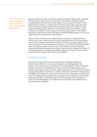


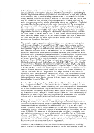
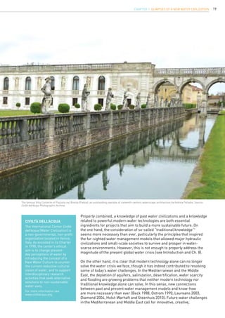
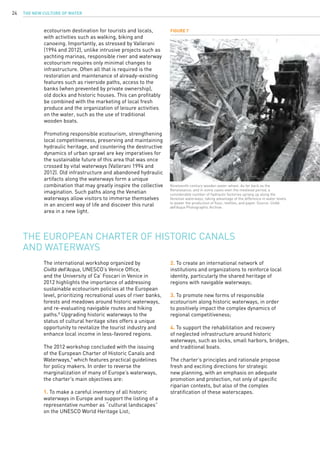
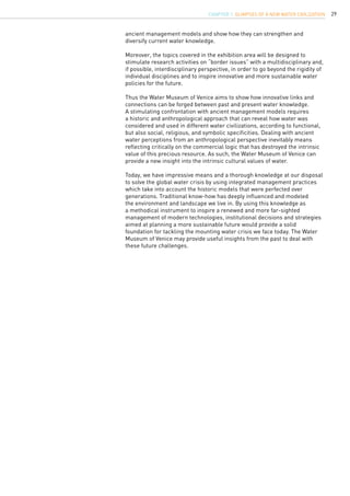
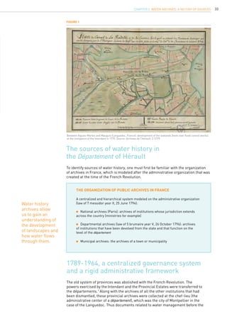
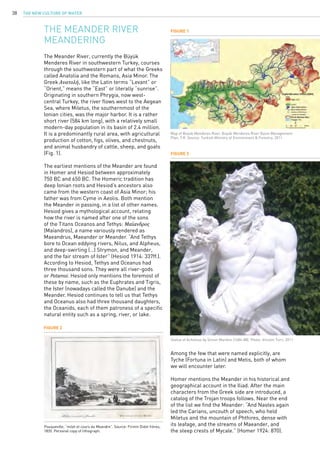
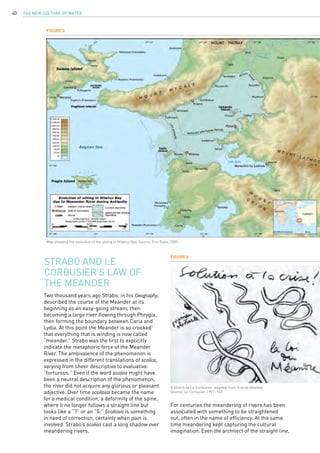
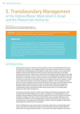
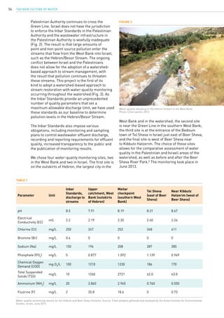
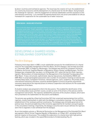
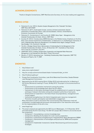
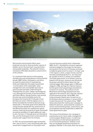
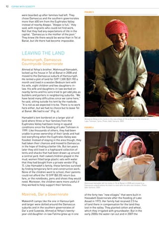
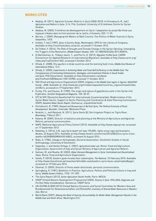
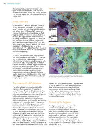
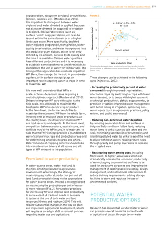
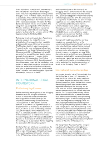
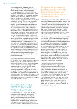
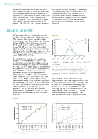
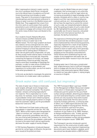
![COPING WITH SCARCITY110
Figure 4
Figure 6
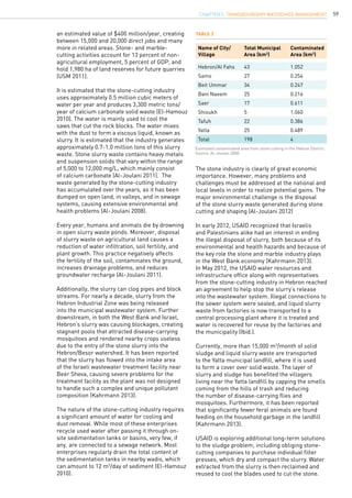
A foggara well. Photo: Taha Ansari, 2010.
View of a foggara outlet, known as the comb or kasria. Photo: Taha
Ansari, 2011.
The topographic and hydrological conditions in
Adrar Province – the natural depression and
the presence of shallow water – make it highly
suitable for the development of foggaras. Indeed,
maps of Adrar Province show that all foggaras
are located in the vicinity of the Tademaït
Plateau. Foggaras in Adrar bring water from the
Intercalary Continental Formation to villages and
palm groves. Foggaras are made up of two distinct
parts: the most important “active” upstream part,
which enters into the aquifer (Fig. 1 and 4); and
the “inactive” downstream part, which allows
the flow of water to crops and settlements. The
foggara outlet, from where different smaller
canals or seguias branch off [Fig.7], is known as
the comb or kasria (Fig. 6).
Foggaras in the Adrar
Local communities manage the foggaras
according to a traditional system that has been in
use for many centuries. Most villages (ksars) have
several foggaras, and each foggara has a name.
Each foggara is managed by a user association,
which is officially recognized by the Algerian
state. The user association is responsible for the
rehabilitation and maintenance of the foggara,
but also forms the link between the inhabitants
of the ksar and the local administration. The 707
perennial foggaras in Adrar Province irrigate 176
palm groves, which cover a total area of 113,353
ha. A variety of vegetables are cultivated here,
including tomatoes, onions, potatoes, garlic,
eggplant, carrots, and peas (Fig. 8).
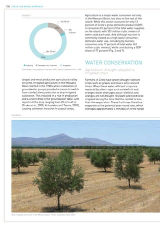
What is a foggara?
A foggara is a network of tunnels and wells
that taps groundwater and provides a reliable
supply of water for human settlements and
irrigation in hot arid and semi-arid climates.
Also known as qanat, khettara and falaj in other
parts of the Middle East and North Africa, the
foggara remains one of the most sustainable
methods of groundwater exploitation as
it relies only on the natural discharge of
the aquifer and therefore never taps the
groundwater beyond a sustainable rate (Fig. 5).
Figure 5
Cross-section and plan of a typical qanat. Source: De Châtel, 2007.](https://image.slidesharecdn.com/c7d6d63b-ab90-42fb-bae8-0d3804f58933-150303061432-conversion-gate01/85/20140925-GWP-MED-PUBLICATION-ONLINE-112-320.jpg)


![COPING WITH SCARCITY116
The MENA countries draw heavily on groundwater
to meet rising demand. Overexploitation and
depletion of groundwater reserves have severe
environmental consequences in addition
to depleting national assets. The mining of
groundwater resources has resulted in rapid
depletion of aquifer reserves, salinization, and
deterioration in water quality. In addition, the
region’s groundwater reserves are threatened
by pollution from agricultural, industrial, and
domestic activities. A recent report on water
referred to the “water crises” in the region and
suggested that “[r]esolving the crisis will require
enduring progress towards political, social,
economic, and administrative systems that shape
the use, development, and management of water
resources and water delivery in a more effective,
strategic, sustainable, and equitable direction”
(Ibid.: iv).
About 80 percent of the region’s total water
resources are used to produce food. However,
high population growth rates and improvements
in living standards mean that more water is
diverted to other priority sectors, such as
domestic and industrial, leaving less water for
agriculture. Ironically, as water for agriculture is
declining, more food is needed and regional food
security is increasingly threatened. In several
countries, such as Jordan, marginal-quality water
has become a major source of irrigation water
(Al-Karaki 2011).
Despite its scarcity, water continues to be
misused. New technologies allow farmers to
extract groundwater at rates far in excess of
recharge, rapidly depleting centuries-old aquifers.
The productivity of water in the region is still low,
but varies depending on crop and country. Water
scarcity and mismanagement will also accelerate
environmental degradation, through soil erosion,
soil and water salinization, and waterlogging.
These are global problems, but they are especially
severe in dry areas (Pereira et al. 2002).
This paper will first highlight general
misconceptions regarding water losses and
savings associated with traditional and modern
practices and methodologies currently in use.
It will then introduce the water productivity
framework and describe true water savings, use
and benefits, and finally suggest some promising
ways of developing sustainable agricultural
models in a context of growing water scarcity.
The majority of water resources in dry areas are
already tapped and used for various purposes
(UNDP 2013). The technical options listed below
New water for
agriculture is limited
could provide additional water resources, though
many obstacles need to be overcome.
- Desalination is a potential new source of
water. However, it remains a costly option that
has negative environmental impacts. Half of the
world’s desalinated water is produced in oil-
rich countries in the MENA region. Desalination
capacity has rapidly increased over the last
decade because of the increase in water demand
and a significant reduction in desalination costs
as a result of significant technological advances.
Under the most favorable conditions, the cost of
desalinated seawater has fallen below $0.50 per
cubic meter while in other locations the cost is
near or above $1.00 per cubic meter (Ghaffour et
al. 2013).
- Brackish water offers some promise. The region
has notable amounts of brackish water, mainly in
groundwater aquifers, which can either be used
directly in agriculture or be desalinated at low
cost for human and industrial use.
- Treated effluent is another important source of
water for agriculture in areas of extreme scarcity,
such as Jordan and Tunisia where it accounts
for about 25 percent of the country’s water
resources. It offers many advantages as it lacks
the uncertainties of surface water resources and
can meet a proportional share of the rising water
demand from urbanization and population growth
(UNDP 2013).
- Agricultural drainage is becoming an attractive
option. In Egypt, drainage water from agricultural
lands is collected in an extensive drainage
network and recycled in the system after it is
mixed with fresh water downstream until it
becomes too saline for productive use. Currently
about 5.5 billion cubic meters of drainage water is
reused in Egypt, a figure that is set to rise to about
10 billion cubic meters by 2017 (Abdel-Shafy and
Mansour 2013).
- Rainwater harvesting represents a real recovery
of otherwise lost water and provides opportunities
for decentralized community-based management
of water resources. In dry environments,
hundreds of billions of cubic meters of rainwater
are lost every year through runoff to salt sinks
and evaporation from bare soil surfaces through
lack of proper management and sustainable
ecosystems development. The International
Center for Agricultural Research in the Dry Areas
(ICARDA) has demonstrated that over 50 percent
of water that is otherwise lost can be captured
through water harvesting and used in agriculture
(Oweis et al. 2012).
- Water transfers between water basins and
between countries have been extensively
discussed in the Middle East over the last few](https://image.slidesharecdn.com/c7d6d63b-ab90-42fb-bae8-0d3804f58933-150303061432-conversion-gate01/85/20140925-GWP-MED-PUBLICATION-ONLINE-118-320.jpg)


![COPING WITH SCARCITY142
• UNRWA (2009), Epidemiological Bulletin for Gaza Strip, vol. 1, February 2009.
• UN International Fact-Finding Mission on Settlements (2013), Report of the independent international
fact-finding mission to investigate the implications of the Israeli settlements on the civil, political, economic,
social, and cultural rights of the Palestinian people throughout the Occupied Palestinian Territory, including East
Jerusalem, Advanced Unedited Version, January 2013, UNHRC 22nd session.
Endnotes
1. This article draws from earlier works by Koek, including: Dugard, J. and Koek, E. (forthcoming
2014) Water Wars: Anti-Privatization Struggles in the Global South. In Alam, S., Atapattu, S., Gonzalez,
C. and Razzaque, J. (eds.) International Environmental Law: Perspectives from the Global South. Cambridge:
Cambridge University Press; Koek, E (2013a, 2013b). The views expressed in this article are those of
the author and do not necessarily represent those of the institutions for which Elisabeth Koek has
worked or currently works.
2. Following the conclusion of the Oslo Accords in the 1990s, the West Bank was carved up in three
Areas. Area A and B are under full Palestinian civil control, while the majority of the West Bank
remains under full Israeli civil and military control, including land registration, planning, building and
designation of land use.
3. Permission for development or rehabilitation of all water infrastructure in the West Bank, whether
Palestinian- or Israeli-initiated, must first be granted by the Joint Water Committee (JWC), a body
established under the 1995 Oslo Accords as part of the five-year interim arrangement. The JWC is
comprised of equal numbers of Israeli and Palestinian representatives and decisions should be made
by consensus, granting either side the right to veto any proposal. Israel can and has used its veto
power to prevent Palestinians from undertaking any substantial water projects in the West Bank.
Based on a comprehensive study into the JWC records between 1995 and 2008, Selby concludes that
approval rates for Palestinian projects are significantly lower than Israeli projects (Selby 2013: 7).
Furthermore, when Palestinians have exercised their veto right through the JWC, Israel proceeds
unilaterally with water projects that serve the settlements.
4. Israel completed the withdrawal of most of its troops and evacuation of the settlements from the
Gaza Strip in September 2005.
5. Israel retains exclusive jurisdiction over the territorial waters and airspace of the Gaza Strip and
full control over its land borders, with the exception of the Rafah crossing. Additionally, Israeli troops
remain stationed along the borders between Israel and the Gaza Strip, enforcing the so-called “buffer
zone” – an area extending over approximately 17 percent of the territory of the Gaza Strip barred to
Palestinian access – and conducting regular raids into cities and villages. For a more comprehensive
analysis, see Al-Haq ‘Al-Haq’s Rejoinder to Gisha’s “Scale of Control” Report: Israel’s Continued
Responsibility as the Occupying Power in the Gaza Strip’ (December 2011).
6. United States of America v A. Krupp et al., US Military Tribunal at Nuremberg (Judgment, 31 July
1948), in Trials of War Criminals before the Nuremberg Military Tribunals, Vol. IX, 1342-1343.
7. Article 2(a) of the Convention on the Law of the Non-Navigational Uses of International
Watercourses, annexed to UNGA, Res 51/229 (21 May 1997) UN Doc. A/RES/51/229 (hereafter: 1997
UN Watercourses Convention).
8. The ICJ declared that the 1997 UN Watercourses Convention, in its entirety, and Article 5 in
particular, reflect “[t]he modern development of international law,” which in turn “reflects in an
optimal way the concept of common utilization of shared water resources.” Gabčíkovo-Nagymaros
Project (Hungary/Slovakia) (Judgement) ICJ Rep 1997, paragraph 78, 85, 147 and 150.
9. Draft Articles on The Law of Transboundary Aquifers, annexed to UNGA Res 63/124 (15 January
2009) UN Doc. A/RES/63/124.
10. Article 5 of the 1997 UN Watercourses Convention.
11. Article 7 of the 1997 UN Watercourses Convention.
12. It has often been said, including by Israeli officials, that control over water resources was one of
the major causes of the 1967 war following escalating tensions over the completion of the National
Water Carrier (NWC), a project crucial to Israel’s planned growth and development of the coastal and
desert regions. The NWC is a pipeline of three meters in diameter, carrying some 1 million cubic
meters of water per day from Lake Tiberias in northern Israel to the coastal cities of Haifa and Tel
Aviv and to the Negev Desert in the south. The NWC continues to severely affect the water supply in
neighboring countries, especially Jordan, where the lower reaches of the Jordan River have been
reduced to “a saline trickle, leaving Jordanian farms along its east bank desperately short of water”
(McCaffrey 2007: 21).](https://image.slidesharecdn.com/c7d6d63b-ab90-42fb-bae8-0d3804f58933-150303061432-conversion-gate01/85/20140925-GWP-MED-PUBLICATION-ONLINE-144-320.jpg)


![CRETE: the mosaic approach168
Ministerial Decision implemented permitting
requirements.
A similar delay in implementation existed for the
broader Framework Law. As Tsakiris et al. note:
…[T]here are some points that led to the
unsuccessful implementation of the Law
1739/87, such as: (i) the multiple distribution
of authorities to different Ministries which
has hampered integrated actions; (ii) the
fact that water resources management was
not incorporated in the environmental
policy; and (iii) the allocation of water quality
and quantity issues within the same area to
different authorities (2005: 51).
Although the Water Framework Law was the
guiding water management legislation for
fifteen years, it was handicapped by incomplete
implementation. Serious water quantity issues
continued. Particularly troubling are continuing
groundwater quantity concerns. Land owners
continue to overexploit groundwater below their
property. Another major problem, highlighted by
Kampa and Bressers (Ibid.), is that permits are
only issued for new water use. This allows water
uses that existed before 1987 to continue without
permission, creating a large gap in legislative
coverage.
Other problems with the 1987 law include lack
of integrated management, which should be
remedied by the Water Framework Directive,
and inadequately funded operational authorities.
Further, it only focused on water quantity issues.
Water quality was governed by the 1986 Law on
the Protection of the Environment. A number of
other semi-overlapping directives and decrees,
both from before and after the passage of
the 1987 Framework Law, made the situation
increasingly complex, especially once E.U. law
began to be implemented.
The 2003 law integrating the E.U. Water
Framework Directive at the national level, the
Law on the Protection and Management of Water
(Law 3199), required the creation of a significant
new administrative structure. Much of this
structure should aid coordination. For example,
the 2003 law created a Ministerial National Water
Committee, which is tasked with creating and
monitoring water policy, and brings together
several different national authorities. The law
also creates Regional Water Directorates in each
administrative region, which are in charge of the
river basins in their regions. If a basin crosses
regions, the directorates may either act together
or the National Water Committee may designate
one directorate to be the lead. The directorates
report annually to a Central Water Agency, also
created by the 2003 law.
The 2003 law also covers both water quantity and
quality. In many important respects, it is a major
step forward in terms of coordination, streamlining
and generally dispelling confusion. Unfortunately,
its implementation was seriously delayed. Further,
according to Kampa and Bressers, “[f]ormal policies
to achieve more integration now seem to be largely
in place but a sufficiently favourable institutional
context is still missing” (Ibid).
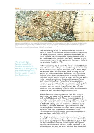
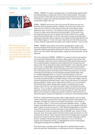
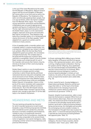
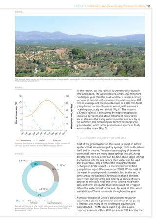
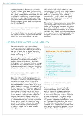
View from the island of Spinalonga. Photo: Diana Biller, 2012.
Model Codes are akin to legal cookbooks:
their primary goal is not uniformity, but
rather to provide a template which a state
or country may adapt to suit their own
environment.](https://image.slidesharecdn.com/c7d6d63b-ab90-42fb-bae8-0d3804f58933-150303061432-conversion-gate01/85/20140925-GWP-MED-PUBLICATION-ONLINE-170-320.jpg)
![169
Crete, besides being governed by the legal
structure briefly summarized above, has also
delegated water provision use and sanitation
legislation to its municipalities. These local
regulations can be quite successful, but there
is also significant risk attached. As the Cornell
research team concluded about the Municipality
of Neapolis, “The Local regulations, governance
and management (which are controlled by the
council headed by the Mayor) has thus far been
more than satisfactory, indeed for such an arid
region it should be complimented. This is not to
say that if it were to be managed in a different way
and the local legislation either varied or ignored
that there would not be problems in the future”
(Saia et al. 2011: 34-35).
For farmers, agricultural water may either be
provided by the municipality or by a TOEB, a
local farmers irrigation organization. TOEBs are
private, non-profit organizations supervised by
the Ministry of Agriculture through the regional
unit level. They were established in 1958, and
“[t]heir objective is to improve the conditions
of the member farms, which are located within
their authority area, regarding water supply”
(Katsikides and Dörflinger 2005: 114).
Researchers report similar legal problems
at the Cretan level as they do at the national
one: coordination problems, too many different
authorities, lack of funding (Chartzoulakis and
Bertaki 2010). Most of these problems were
confirmed by my own observations.
In addition to my own problems of limited
expertise in researching the law, our team also
had to learn to navigate between disciplines,
particularly to find a language to communicate
between law and engineering. This is seemingly
an important goal far beyond our own small team,
particularly as we observed in the Cretan case,
engineers frequently end up practicing water
law in regions where lawyers with expertise in
water or environmental law are rare.2
Lawyers
and engineers both communicate in highly
technical languages, which are frequently difficult
to translate. For example, when thinking about
“water” a lawyer might first consider “property”
(indeed, water law in the U.S. is frequently first
taught in a property law course), but “property”
to a lawyer is likely to be a specialized area of
law composed of theory, regulation, treaties,
Cretan water law
constitutions, judicial decisions, etc. (all of these
shifting, appearing, or disappearing depending on
the jurisdiction). Not being an engineer I do not
know what an equivalent example might be, but
I imagine that the differences in training would
result in quite different results. Sometimes the
words might be the same, but the meaning of the
words is not.
My year-long experience as a law student
engaging in water law was personally
transformative. It broadened my view of law,
emphasizing both the extreme differences in
law between jurisdictions and the necessity of
engaging with other disciplines in areas like water
law. It also highlighted the problems of such an
approach. In the end, it made me aware of the
world beyond the American law school.
The Lasithi Plateau. Photo: Diana Biller, 2012.
CHAPTER 18. A Year in Mediterranean Waters](https://image.slidesharecdn.com/c7d6d63b-ab90-42fb-bae8-0d3804f58933-150303061432-conversion-gate01/85/20140925-GWP-MED-PUBLICATION-ONLINE-171-320.jpg)