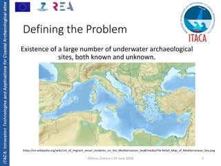
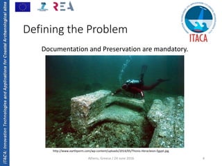
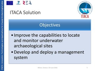
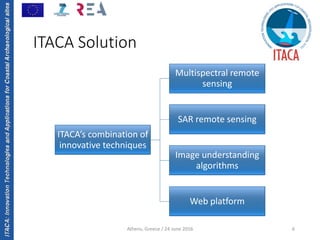
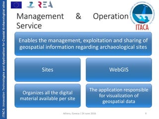
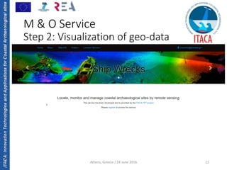
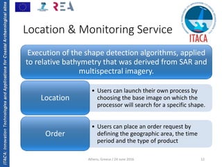
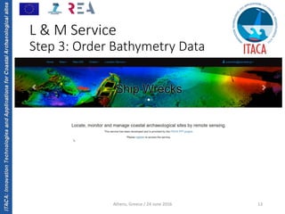
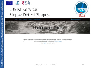
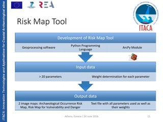
ITACA:InnovationTechnologiesandApplicationsforCoastalArchaeologicalsites
Management & Monitoring of 
Underwater Archaeological Sites: An 
Innovative Approach
Dimitrios Ioannidis
ioannidis@planetek.gr
ITACA Final Conference: Satellite Remote Sensing Technology in 
Underwater Archaeology 
Athens, Greece / 24 June 2016 1
The research leading to these results has received funding from 
the European Community's Seventh Framework Programme 
([FP7/2007‐2013]) under grant agreement n° 606805
ITACA:InnovationTechnologiesandApplicationsforCoastalArchaeologicalsites
Defining the Problem
ITACA Solution
Management & Operation Service
Location & Monitoring Service
Risk Map Tool
Conclusions
Athens, Greece / 24 June 2016 2
Agenda
ITACA:InnovationTechnologiesandApplicationsforCoastalArchaeologicalsites
Athens, Greece / 24 June 2016 3
Defining the Problem
Existence of a large number of underwater archaeological 
sites, both known and unknown.
https://en.wikipedia.org/wiki/List_of_migrant_vessel_incidents_on_the_Mediterranean_Sea#/media/File:Relief_Map_of_Mediterranean_Sea.png
ITACA:InnovationTechnologiesandApplicationsforCoastalArchaeologicalsites
Athens, Greece / 24 June 2016 4
Defining the Problem
Documentation and Preservation are mandatory.
http://www.earthporm.com/wp‐content/uploads/2014/05/Thonis‐Heracleion‐Egypt.jpg
ITACA:InnovationTechnologiesandApplicationsforCoastalArchaeologicalsites
Athens, Greece / 24 June 2016 5
ITACA Solution
Objectives
•Improve the capabilities to locate 
and monitor underwater 
archaeological sites
•Develop and deploy a management 
system
ITACA:InnovationTechnologiesandApplicationsforCoastalArchaeologicalsites
Athens, Greece / 24 June 2016 6
ITACA Solution
ITACA’s combination of 
innovative techniques
Multispectral remote 
sensing
SAR remote sensing
Image understanding 
algorithms
Web platform
ITACA:InnovationTechnologiesandApplicationsforCoastalArchaeologicalsites
Athens, Greece / 24 June 2016 7
ITACA Solution
ITACA:InnovationTechnologiesandApplicationsforCoastalArchaeologicalsites
Athens, Greece / 24 June 2016 8
ITACA Solution
ITACA Services
Location & Monitoring Service
• Provides users with tools to search for various 
underwater cultural assets
Management & Operation Service
• Offers tools to manage geo‐information related to 
underwater archaeological sites
ITACA:InnovationTechnologiesandApplicationsforCoastalArchaeologicalsites
Athens, Greece / 24 June 2016 9
Management & Operation
Service
Enables the management, exploitation and sharing of 
geospatial information regarding archaeological sites
Sites
Organizes all the digital 
material available per site 
WebGIS
The application responsible 
for visualization of 
geospatial data
ITACA:InnovationTechnologiesandApplicationsforCoastalArchaeologicalsites
Athens, Greece / 24 June 2016 10
M & O Service 
Step 1: Definition of Site
ITACA:InnovationTechnologiesandApplicationsforCoastalArchaeologicalsites
Athens, Greece / 24 June 2016 11
M & O Service
Step 2: Visualization of geo‐data
ITACA:InnovationTechnologiesandApplicationsforCoastalArchaeologicalsites
Athens, Greece / 24 June 2016 12
Location & Monitoring Service
Execution of the shape detection algorithms, applied 
to relative bathymetry that was derived from SAR and 
multispectral imagery.
• Users can launch their own process by 
choosing the base image on which the 
processor will search for a specific shape.
Location
• Users can place an order request by 
defining the geographic area, the time 
period and the type of product 
Order 
ITACA:InnovationTechnologiesandApplicationsforCoastalArchaeologicalsites
Athens, Greece / 24 June 2016 13
L & M Service
Step 3: Order Bathymetry Data
ITACA:InnovationTechnologiesandApplicationsforCoastalArchaeologicalsites
Athens, Greece / 24 June 2016 14
L & M Service
Step 4: Detect Shapes
ITACA:InnovationTechnologiesandApplicationsforCoastalArchaeologicalsites
Athens, Greece / 24 June 2016 15
Risk Map Tool
Output data
2 image maps: Archaeological Occurrence Risk 
Map, Risk Map for Vulnerability and Danger
Text file with all parameters used as well as 
their weights
Input data
> 20 parameters Weight determination for each parameter
Development of Risk Map Tool
Geoprocessing software
Python Programming 
Language
ArcPy Module
ITACA:InnovationTechnologiesandApplicationsforCoastalArchaeologicalsites
Athens, Greece / 24 June 2016 16
Risk Map Tool
ITACA:InnovationTechnologiesandApplicationsforCoastalArchaeologicalsites
Athens, Greece / 24 June 2016 17
Conclusions
Combines different scientific and technological 
fields: Innovative Approach.
Cost effective due to large availability of 
satellite image data.
Web‐platform can play the role of a universal 
reference point for underwater archaeological 
research.
Issues with availability of image data with 
favorable conditions.
Traditional archaeological methods (coring, 
excavation) will never be replaced.
Current Status: Final phase and extensively 
tested.
ITACA:InnovationTechnologiesandApplicationsforCoastalArchaeologicalsites
Thank you
18
ITACA project is coordinated by Planetek Hellas E.P.E. (GR) and includes the following 
institutes and companies: Kell Srl (IT), NAIS Srl (IT), DHI GRAS (DK), I.EN.A.E (GR), FFCUL (PT), 
ANESTI Ltd (UK), Regione Sicilia (IT), ALMA sas (IT), CODEVINTEC Srl (IT), SME4SPACE (BE)
Athens, Greece / 24 June 2016

1.ITACA_PKH_Ioannidis