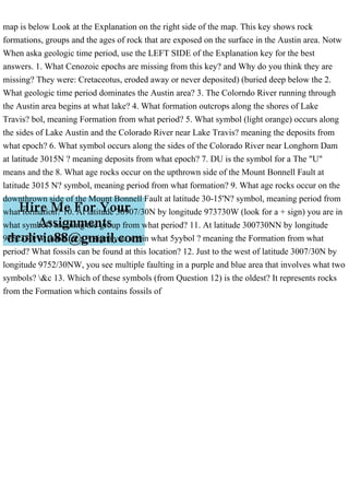
map is below Look at the Explanation on the right side of the map. This key shows rock
formations, groups and the ages of rock that are exposed on the surface in the Austin area. Notw
When aska geologic time period, use the LEFT SIDE of the Explanation key for the best
answers. 1. What Cenozoic epochs are missing from this key? and Why do you think they are
missing? They were: Cretaceotus, eroded away or never deposited) (buried deep below the 2.
What geologic time period dominates the Austin area? 3. The Colorndo River running through
the Austin area begins at what lake? 4. What formation outcrops along the shores of Lake
Travis? bol, meaning Formation from what period? 5. What symbol (light orange) occurs along
the sides of Lake Austin and the Colorado River near Lake Travis? meaning the deposits from
what epoch? 6. What symbol occurs along the sides of the Colorado River near Longhorn Dam
at latitude 3015N ? meaning deposits from what epoch? 7. DU is the symbol for a The "U"
means and the 8. What age rocks occur on the upthrown side of the Mount Bonnell Fault at
latitude 3015 N? symbol, meaning period from what formation? 9. What age rocks occur on the
downthrown side of the Mount Bonnell Fault at latitude 30-15'N? symbol, meaning period from
what formation? 10. At latitude 30907/30N by longitude 973730W (look for a + sign) you are in
what symbol? meaning the group from what period? 11. At latitude 300730NN by longitude
9752330rW (look for a + sign) you are in what 5yybol ? meaning the Formation from what
period? What fossils can be found at this location? 12. Just to the west of latitude 3007/30N by
longitude 9752/30NW, you see multiple faulting in a purple and blue area that involves what two
symbols? \&c 13. Which of these symbols (from Question 12) is the oldest? It represents rocks
from the Formation which contains fossils of.
map is below Look at the Explanation on the right side of the map. T.pdf
1. map is below Look at the Explanation on the right side of the map. This key shows rock
formations, groups and the ages of rock that are exposed on the surface in the Austin area. Notw
When aska geologic time period, use the LEFT SIDE of the Explanation key for the best
answers. 1. What Cenozoic epochs are missing from this key? and Why do you think they are
missing? They were: Cretaceotus, eroded away or never deposited) (buried deep below the 2.
What geologic time period dominates the Austin area? 3. The Colorndo River running through
the Austin area begins at what lake? 4. What formation outcrops along the shores of Lake
Travis? bol, meaning Formation from what period? 5. What symbol (light orange) occurs along
the sides of Lake Austin and the Colorado River near Lake Travis? meaning the deposits from
what epoch? 6. What symbol occurs along the sides of the Colorado River near Longhorn Dam
at latitude 3015N ? meaning deposits from what epoch? 7. DU is the symbol for a The "U"
means and the 8. What age rocks occur on the upthrown side of the Mount Bonnell Fault at
latitude 3015 N? symbol, meaning period from what formation? 9. What age rocks occur on the
downthrown side of the Mount Bonnell Fault at latitude 30-15'N? symbol, meaning period from
what formation? 10. At latitude 30907/30N by longitude 973730W (look for a + sign) you are in
what symbol? meaning the group from what period? 11. At latitude 300730NN by longitude
9752330rW (look for a + sign) you are in what 5yybol ? meaning the Formation from what
period? What fossils can be found at this location? 12. Just to the west of latitude 3007/30N by
longitude 9752/30NW, you see multiple faulting in a purple and blue area that involves what two
symbols? &c 13. Which of these symbols (from Question 12) is the oldest? It represents rocks
from the Formation which contains fossils of