SlideShare a Scribd company logo
1 of 13
Download to read offline
8.3 Lithified Sedimentary Rocks 299
Lake
Michigan
Wisconsin
Illinois
Scale:
A FIGURE 8.12
Area where Maquoketa shale is thin or missing and direct
recharge to the CambrianOrdovician aquifer can occur.
Source: C. W. Fetter, Jr., Ground Water 79 (1981): 201—
13. O Ground Water Publishing Company. Used with
permission.
i«etric in theaq#r hasdèîlinèd
in ibis
thè
300 Chapter Geology of Ground-Water Occurrence
8
750
Potentiometric surface of Cambrian-Ordovician aquifer in
southeastern Wisconsin and northeastern Illinois. A. About
1865—1880. B. In 1973. Source: C. W. Fetter, Jr., Ground
Water 7 9 (1981): 207—13. © Ground Water Publishing Company.
Used with permission.
8.3.1 Complex Stratigraphy
The fact that a formation may change in lithology from one locality to another accounts
for some of the difficulties associated with studies of sedimentary rock units. For
example, a sandstone may grade into a shaly sandstone or siltstone, yet still have the
same fossil fauna assemblage and the same stratigraphic nomenclature. The Eau Claire
Formation of Cambrian age is a sandstone in east-central Wisconsin, but it grades into a
shale and siltstone in northern Illinois. In Wisconsin, it has high conductivity and is an
aquifer; in Illinois, it becomes a confining layer (Walton 1965; Schicht, Adams, & Stall
1976).
Complex stratigraphy can be a very real hindrance to ground-water exploration. On
the Hualapai Plateau of northwestern Arizona, the best potential aquifer is the
stratigraphic sequence of sedimentary rocks in the Rampart Cave Member of the Muav
Limestone Formation (Twenter 1962). Springs discharge from this member into the
Grand Canyon along the flanks of the plateau. The Bright Angel Shale stratigraphically
underlies the Rampart Cave Member of the Muav Limestone, causing the ground water
to be perched (Figure 8.14). However, because these units were being deposited in a
800M
850k'
A FIGURE
8.1
3
transgressing sea, the various beds are interfingering. As a result, at some localities the
Bright Angel Shale can be both above and below the Rampart Cave Member (Figure
8.15). Drillers in the area have had unsuccessful wells because they stopped drilling
when the Bright Angel
Unit Age Thickness (ft) Lithology
Gravels,
Basalt, Tuff
esco ame
ormat10
Tertia 0—1000
2
Manakacha
Formation
Wata omi i
Formatio
250
200
Redwall
Limestone 600-675
Temple Butte
Formation
n tvi
Devon ian 400-450
1
Muav Limestone 800-1200
Bright Angel
Shale
400—
450
apeats andstone
Vrshnu Schist Precambrian
EXPLANATION
Sandstone- Shale Limestone Dolomite Chert
Siltstone
Gravel Igneous- Basalt-Unconformity
Metamorphic Tuff
A FIGURE 8.14
Stratigraphy of the Grand Canyon area. Source: P. W. Huntoon,
Ground Water 15 (7 977): 426—33. © Ground Water Publishing
Company. Used with permission.
302 Chapter Geology of Ground-Water Occurrence
Bright
Angel
Shale
A FIGURE 8.15
Interfingering of sedimentary rock units of the Hualapai
Plateau area. Source: Adapted from P. W. Huntoon, Ground
Water 15 (7 977): 426—33. © Ground Water Publishing
Company. Used with permission.
301
8
Shale was first reached (Huntoon 1977). Unfortunately, the target formation had not yet
been penetrated. A well drilled at Location A of Figure 8.15 would not hit Bright Angel
Shale until the Rampart Cave Member was penetrated. However, at location B, three
shale members alternating with limestone would have to be penetrated before the
Rampart Cave Member was reached. The area of these interfingering members extends
for tens of miles. The hydrogeologist working in areas of such complex stratigraphy must
be aWare of the possible hydrogeologic consequences.
8.3.2 Folds and Faults
Folding and faulting of sedimentary rocks can create very complex hydrogeologic
tems, in which determination of the locations of recharge and discharge zones and flow
systems is confounded. Not only must the hydrogeologist determine the hydraulic
characteristics of rock •units and measure ground-water levels in wells to determine flow
systems, but detailed geology must also be evaluated. In most cases, the basic geologic
structure will have already been determined; however, logs of test wells and borings must
be reconciled with the preexisting geologic knowledge.
Fault zones can act either as barriers to ground-water flow or as ground-water
conduits, depending upon the nature of the material in the fault zone. If the fault zone
consists of finely ground rock and clay (gouge), the material may have a very low
hydraulic conductivity. Significant differences in ground-water levels can occur across
such faults (see Figures 8.9 and 8.10). Impounding faults can occur in unconsolidated
materials with clay present, as well as in sedimentary rocks where interbedded shales,
which normally would not hinder lateral ground-water flow, can be smeared along the
fault by drag folds. Clastic dikes are intrusions of sediment that are forced into rock
fractures. If they are clay-rich, they can act as ground-water barriers in either sediments or
in a lithified sedimentary rock. Clastic dikes are known to occur in alluvial sediments,
glacial outwash, and lithified sedimentary rock.
Faults in consolidated rock units can act either as pathways for water movement or as
flow barriers. If there has been little displacement along the fault, then the fault is more
likely to develop fracture permeability because there is less opportunity for the formation
of soft, ground-up rock, called gouge, to form between the moving surfaces (Huntoon
1986). Fault gouge can have a matrix of rock breccia encased in clay and can have a wider
range of permeability (Snipes et al. 1986). Faults in poorly consolidated rocks in South
Muav Limestone
—
Carolina had greater permeability than those in well-consolidated rocks (Snipes et al.
1986).
If the fault zone has a high porosity and hydraulic conductivity, it can serve as a
conduit for ground-water movement. Springs discharging into the Colorado River in
Marble Canyon are controlled by a vertical fault zone, the Fence Fault. The springs
discharge where the faults intersect the river. The fault zones provide for vertical
movement of recharging ground water from the land surface as well as lateral movement
toward the river. The geochemistry of the spring water indicates that some of the water
discharging on one side of the river originated in the ground-water basin on the opposite
side of the river, indicating the fault zone was conducting some ground-water flow
beneath the river even though it is a regional discharge zone (Huntoon 1981).
Faults may contain ground water at great pressures at depths where tunnels or mines
may be constructed. One danger of hard-rock tunneling is the possibility of breaching an
unexpected fault zone. Damaging and dangerous flooding can occur if the fault contains
ground water with a high hydraulic head. In Utah, a well being drilled through an
anticlinal structure, which in an unfaulted state creates a regional confining layer,
encountered an exceptionally high-permeability zone created by normal faults and
associated extensional joints that imprinted joint permeability on the brittle rocks. The
well was being
304 Chapter 8 Geology of Ground-Water
Occurrence
Tertiary
cover
HOMOCLINAL
MARGIN
5000 ft
15—60 miles
MOUNTAIN
UPLIFT
10,000 ft
-
SEVERED
MARGIN
Tertiary
cover
s ic roc
PalQ0R9iç: rqqks
FIGURE 8.16
Schematic cross section through a typical Wyoming mountain
uplift showing the style of deformation that results in
approximately equal percentages of fault severed and
homoclinal basin perimeters. Source: P. W. Huntoon, Ground
Water 23 (7 985): 7 76—81. C) Ground Water Publishing Company.
Used with permission.
drilled to initiate solution mining of an abandoned underground potash mine.
Unfortunately, ground water under high pressure in the fracture zone rushed into the well
boring when the mine level was reached and flooded it with mineralized water (Huntoon
1986).
Overthrust faulting can create conditions in which a rock, normally found as an
impermeable basement unit, is overlying the sedimentary rock units, typically a
groundwater source. In such a case, the hydrogeologist might recommend drilling through
the "basement" rocks to attempt to obtain a ground-water supply from younger
sedimentary units, provided there is an opportunity for recharge to occur and the water is
not known to have a high mineral content (Figure 8.16).
The major artesian basins of Wyoming consist of sedimentary rock units bounded by
major thrust faults. The fault-severed margins of the basins have good permeability,
adequate recharge, and good-quality water in the sedimentary rock aquifers of the hanging
wall. However, the foot-wall rocks receive little recharge, have poor-quality water, and
have permeabilities often many orders of magnitude lower than those of the adjacent
hanging wall segments of the same formation (Huntoon 1985).
Is tog-round-V@ter flow,
W
p,
8.3 Lithified Sedimentary Rocks305
Ðtþrbekisunižotmlyfragturèdw1 depthÅåtRmoreextenFiÿe fractured-zones inthe rock
LEGEND
O PRODUCTION
MONITORING WELL
FAULT
Eastern
Fault Block
North Main
Cross-Fault
Eastern
P23 Fault Block
T24 P22
Ml
Central Il
Fault Block Bl
Cross-Fault
T33
T31 Central I
P21
Fault Block
TORY
P32 Eastern Fault
Western o
Fault Block rapids
Central Fault
200m
Western Fault scale
A FIGURE 8.17
Locations of wells, faults, and fault blocks, Carlton University.
Source: Allen, Diana M. and Frederick A. Michel. 1998. Ground Water
36. no. 6:938—948 © Ground Water Publishing Company. Used with
permission.
indicate
theßyOf4@lt blocks
ssivities. The centfrål zone zone had a
transmissivitÿ bf aŽ56
306 Chapter 8 Geology of Ground-Water
Occurrence
Séne that 9.26 separates ft /daÿ
(0.86 the mtwo 2
/daÿOaquifer
þIoçksÁÅta' of
Folding can affect the hydrogeology of sedimentary rocks in
several ways. The most obvious is the creation of confined
aquifers at the centers of synclines. The nature of the fold
will affect the availability of water. A tight, deeply plunging
fold might carry the aquifer too deep beneath the surface to be
economically developed. Deeply circulating ground water is also
typically warmed by the geothermal gradient and may be highly
SIMPLIFIED STRATIGRAPHIC PROFILE
ALONG THE LINE
A-AI
60
mast 0
LEGEND
shale
siltstone
sandstone
100limestone
dolostone
calcaren
200
SIMPLIFIED STRATIGRAPHIC PROFILE
ALONG THE LINE B-B I
60
masl O
100
8.3 Lithified Sedimentary Rocks307
200
B
A FIGURE 8.18
Stratigraphic cross sections across Carlton University campus.
Cross section locations shown on Figure 8.16. Source: Allen,
Diana M. and Frederick A. Michel. 7998. Ground Water 36. no.
6:938—948. © Ground Water Publishing Company. Used with
permission.
mineralized. A broad, gentle fold can create a relatively
shallow, confined aquifer that extends over a large area. This
might be a good source of water if sufficient recharge can
occur through the confining layer or if the aquifer can
transmit enough water from areas where the confining layer is
absent.
Another effect of folding is to create a series of outcrops
of soluble rock, such as limestone, alternating with rock units
that are not as permeable. Smaller streams flowing the
limestone might sink at the upper end, only to reappear at the
lower outcrop. The type of trellis drainage that can develop on
folded rocks is shown in Figure 8.20. Surace streams follow the
strike of rock outcrops, usually along fault or fracture
traces. In •olded sedimentary rocks with solutional conduits in
carbonate units, ground-water flow nay be along the conduits
that parallel the strike of the fold and not down the dip.
In areas of homoclinal folds, the outcrop areas usually have
bands of sedimentary ocks, with resistant rocks forming ridges
and more easily erodable rocks forming valleys.
308 Chapter 8 Geology of Ground-Water
Occurrence
A FIGURE 8.19
Static hydraulic head measurements in wells on Carlton
University campus. Data from Allen, Diana M. and Frederick A.
Michel. 1999. Ground Water 37. no, 5: 718—728.
The ridges may create ground-water divides, with aquifers outcropping in the valleys. The
outcrop area of an aquifer will have local water-table flow systems with relatively large
amounts of water circulating. These areas also serve as the recharge zones for the more distal
parts of the aquifer, which are downdip in the basin and confined. There is a limited amount of
natural discharge from the confined portions of the aquifer, this is, typically upward leakage
into overlying beds with lower hydraulic head. Because of poor groundwater circulation, the
confined portions of the aquifer may have low hydraulic conductivity and poor water quality
(LeGrand & Pettyjohn 1981).
Complex folded and faulted sedimentary rock units are a challenge to the hydrogeologist.
Competency in geology is necessary in order to construct geologic cross sections based on
well logs, drill-core samples, and outcrops. Regional flow systems can be controlled by the
structural and stratigraphic relations of the confining beds and aquifer units. In addition,
distribution of hydraulic potential must be determined, very often from limited data.
8.3 Lithified Sedimentary Rocks309
FIGURE 8.20
Drainage pattern developed in an area of
longitudinally folded rock strata: A. Top view. B.
Cross section.
Birds-eye
view
Fracture trace
Cross section
8.33 Clastic Sedimentary Rocks
Hydraulic conductivity of clastic sedimentary rocks, based on
primary permeability, is a function of the grain size, shape,
and sorting of the original sediment. The same factors that
affect the permeability and porosity of loose sediments also
are important in sedimentary rocks. Cementation, in which parts
of the voids are filled with precipitated material such as
silica, calcite, or iron oxide, can reduce the original
porosity. Solution of the original material or cementing agent
may occur during and after diagenesis, resulting in an increase
in porosity.
Consolidated rocks also contain secondary porosity and
permeability due to fracturing. Microfractures may add very
little to the original hydraulic characteristics; however,
major fracture zones may have localized hydraulic
conductivities several orders of magnihide greater than that of
the unfractured rock. Fracturing can occur through several
geoogic processes. Rock at depth is under great pressure owing
to the weight of the )verburden. As uplift and erosion bring
the consolidated rock to the surface, it expands as he pressure
is reduced. The expansion can cause fracturing of the rock,
o o o o
o
310 Chapter 8 Geology of Ground-Water
Occurrence
with the majority the expansion fractures occurring within
about 300 ft (100 m) of the surface. Vertical ractures carry
recharging precipitation downward and provide a very important
function n bypassing low-permeability layers near the surface.
Wells located in surface fracture ones are generally highly
successful.
c
A FIGURE 8.21
Sedimentary conditions producing a sandstone aquifer of variable thickness: A. Sandstone
deposited in a sedimentary basin. B. Sandstone deposited unconformably over an erosional
surface. C. Surface of sandstone dissected by erosion prior to deposition of overlying beds.
Fracturing may also be associated with tectonic activity. Rock deformed by faulting or
folding may fracture when subjected to tension or compression. Such activity can take place at
substantial depths; thus, secondary permeability is not strictly a near-surface phenomenon.
However, great pressure on the deeper fractures does not permit them to be as open (have as
great a porosity) as shallow fractures.
The yield to wells is proportional to the transmissivity of the aquifer. This, in turn, is
proportional to the aquifer thickness if the hydraulic conductivity is uniform throughout the
aquifer. Sedimentary aquifers were deposited in sedimentary basins in which units gradually
thicken. Variable thickness of a sedimentary aquifer may also be due to the deposition of the
aquifer material over an eroded surface with high relief or a dissection of the top of the aquifer
after deposition (Figure 8.21). Higher well yields will be obtained from thicker sections of the
aquifer. The relationship between the specific capacity of wells and the uncased thickness of
two sandstone aquifers in northern Illinois is shown in Figure 8.22.
Wells in sandstone aquifers should be located in such a manner as to penetrate the
maximum saturated thickness of the aquifer. If one area of the aquifer is known to have a
higher hydraulic conductivity than other areas, the combination of hydraulic conductivity and
Sandstone
8.3 Lithified Sedimentary Rocks311
thickness should be considered in order to locate the well in the area of greatest aquifer
transmissivity.
The yield of sandstone wells can sometimes be increased by the detonation of explosives
in the uncased hole. The shots are generally located opposite the most permeable zones of the
sandstone. The loosened rock and sand is bailed from the well prior to the installation of the
pump. The shooting process has two effects on the borehole: it enlarges

More Related Content

What's hot

Statza, Takatch, Schwartz_2014_Architecture Tide-Dom Shoreface (1)
Statza, Takatch, Schwartz_2014_Architecture Tide-Dom Shoreface (1)Statza, Takatch, Schwartz_2014_Architecture Tide-Dom Shoreface (1)
Statza, Takatch, Schwartz_2014_Architecture Tide-Dom Shoreface (1)Mary Statza
 
Reservoir Characteristics of Complex TightGas Reservoir for Second Member of ...
Reservoir Characteristics of Complex TightGas Reservoir for Second Member of ...Reservoir Characteristics of Complex TightGas Reservoir for Second Member of ...
Reservoir Characteristics of Complex TightGas Reservoir for Second Member of ...iosrjce
 
importance of shelf edge delta for hydrocarbon exploration
importance of shelf edge delta for hydrocarbon explorationimportance of shelf edge delta for hydrocarbon exploration
importance of shelf edge delta for hydrocarbon explorationAbzal Alpysbayev
 
catawba river geology
catawba river geologycatawba river geology
catawba river geologyguest49cc20a
 
Geological work of natural agencies like rivers
Geological work of natural agencies like  riversGeological work of natural agencies like  rivers
Geological work of natural agencies like riversRAMPRASAD KUMAWAT
 
Ground water harvesting
Ground water harvestingGround water harvesting
Ground water harvestingRishavRay4
 
GREENSTONE-HOSTED QUARTZ-CARBONATE VEIN DEPOSITS
GREENSTONE-HOSTED QUARTZ-CARBONATE VEIN DEPOSITSGREENSTONE-HOSTED QUARTZ-CARBONATE VEIN DEPOSITS
GREENSTONE-HOSTED QUARTZ-CARBONATE VEIN DEPOSITSNuukfjord Gold Ltd.
 
Geological action of river
Geological action of riverGeological action of river
Geological action of riverRizwan Siddique
 
Basin Analysis Labs
Basin Analysis LabsBasin Analysis Labs
Basin Analysis LabsFaisal Hayat
 
Wouterspan resource summary July 2013
Wouterspan resource summary July 2013Wouterspan resource summary July 2013
Wouterspan resource summary July 2013James AH Campbell
 
thesis summary bowen basin symposium poster meggie doran
thesis summary bowen basin symposium poster meggie doranthesis summary bowen basin symposium poster meggie doran
thesis summary bowen basin symposium poster meggie doranMeggie Doran
 
Geological synthesis excercise in stonehaven using fieldmove app
Geological synthesis excercise in stonehaven using fieldmove app Geological synthesis excercise in stonehaven using fieldmove app
Geological synthesis excercise in stonehaven using fieldmove app TomAdamson7
 
McKechnie et al. GAC-MAC 2013 Presentation
McKechnie et al. GAC-MAC 2013 PresentationMcKechnie et al. GAC-MAC 2013 Presentation
McKechnie et al. GAC-MAC 2013 PresentationChristine McKechnie
 
CRFB Field Trip 2016
CRFB Field Trip 2016CRFB Field Trip 2016
CRFB Field Trip 2016Max Barnett
 

What's hot (20)

Statza, Takatch, Schwartz_2014_Architecture Tide-Dom Shoreface (1)
Statza, Takatch, Schwartz_2014_Architecture Tide-Dom Shoreface (1)Statza, Takatch, Schwartz_2014_Architecture Tide-Dom Shoreface (1)
Statza, Takatch, Schwartz_2014_Architecture Tide-Dom Shoreface (1)
 
Structural Geology II
Structural Geology IIStructural Geology II
Structural Geology II
 
Reservoir Characteristics of Complex TightGas Reservoir for Second Member of ...
Reservoir Characteristics of Complex TightGas Reservoir for Second Member of ...Reservoir Characteristics of Complex TightGas Reservoir for Second Member of ...
Reservoir Characteristics of Complex TightGas Reservoir for Second Member of ...
 
importance of shelf edge delta for hydrocarbon exploration
importance of shelf edge delta for hydrocarbon explorationimportance of shelf edge delta for hydrocarbon exploration
importance of shelf edge delta for hydrocarbon exploration
 
catawba river geology
catawba river geologycatawba river geology
catawba river geology
 
Thesis Abstract
Thesis AbstractThesis Abstract
Thesis Abstract
 
Basins & petroleum
Basins & petroleumBasins & petroleum
Basins & petroleum
 
Geological work of natural agencies like rivers
Geological work of natural agencies like  riversGeological work of natural agencies like  rivers
Geological work of natural agencies like rivers
 
Ground water harvesting
Ground water harvestingGround water harvesting
Ground water harvesting
 
GREENSTONE-HOSTED QUARTZ-CARBONATE VEIN DEPOSITS
GREENSTONE-HOSTED QUARTZ-CARBONATE VEIN DEPOSITSGREENSTONE-HOSTED QUARTZ-CARBONATE VEIN DEPOSITS
GREENSTONE-HOSTED QUARTZ-CARBONATE VEIN DEPOSITS
 
Geological action of river
Geological action of riverGeological action of river
Geological action of river
 
Basin Analysis Labs
Basin Analysis LabsBasin Analysis Labs
Basin Analysis Labs
 
Wouterspan resource summary July 2013
Wouterspan resource summary July 2013Wouterspan resource summary July 2013
Wouterspan resource summary July 2013
 
River Tees
River TeesRiver Tees
River Tees
 
thesis summary bowen basin symposium poster meggie doran
thesis summary bowen basin symposium poster meggie doranthesis summary bowen basin symposium poster meggie doran
thesis summary bowen basin symposium poster meggie doran
 
Engineering geology of dam
Engineering geology of damEngineering geology of dam
Engineering geology of dam
 
Geological synthesis excercise in stonehaven using fieldmove app
Geological synthesis excercise in stonehaven using fieldmove app Geological synthesis excercise in stonehaven using fieldmove app
Geological synthesis excercise in stonehaven using fieldmove app
 
Dissertation
DissertationDissertation
Dissertation
 
McKechnie et al. GAC-MAC 2013 Presentation
McKechnie et al. GAC-MAC 2013 PresentationMcKechnie et al. GAC-MAC 2013 Presentation
McKechnie et al. GAC-MAC 2013 Presentation
 
CRFB Field Trip 2016
CRFB Field Trip 2016CRFB Field Trip 2016
CRFB Field Trip 2016
 

Similar to Complex Stratigraphy and Structural Geology Impact Groundwater Flow

sequence characteristic.pptx
sequence characteristic.pptxsequence characteristic.pptx
sequence characteristic.pptxSaadTaman
 
conglomerate facies.pptx
conglomerate facies.pptxconglomerate facies.pptx
conglomerate facies.pptxSaadTaman
 
Unit 8 Moving ground
Unit 8 Moving groundUnit 8 Moving ground
Unit 8 Moving groundE2 Consulting
 
single braided river deltas.pptx
single braided river deltas.pptxsingle braided river deltas.pptx
single braided river deltas.pptxSaadTaman
 
Esl 2005 04_tuba
Esl 2005 04_tubaEsl 2005 04_tuba
Esl 2005 04_tubaUsama Waly
 
Chapter 7_ Hydrogeology PoU.pptx
Chapter 7_ Hydrogeology PoU.pptxChapter 7_ Hydrogeology PoU.pptx
Chapter 7_ Hydrogeology PoU.pptxSunilBhatt60
 
Explain the formation of limestone features
Explain the formation of limestone featuresExplain the formation of limestone features
Explain the formation of limestone featuresTacius Golding High
 
Reservoir Geology Assessed Practical
Reservoir Geology Assessed PracticalReservoir Geology Assessed Practical
Reservoir Geology Assessed Practicallwandfluh
 
CHEE1009 Introductory Geology.docx
CHEE1009 Introductory Geology.docxCHEE1009 Introductory Geology.docx
CHEE1009 Introductory Geology.docxwrite31
 
Mudstone facies.pptx
Mudstone facies.pptxMudstone facies.pptx
Mudstone facies.pptxSaadTaman
 
Carst de Cardona
Carst de CardonaCarst de Cardona
Carst de Cardonaguestb30f29
 
Karst processes and engineering classification
Karst processes and engineering classificationKarst processes and engineering classification
Karst processes and engineering classificationAmr Elgabri
 

Similar to Complex Stratigraphy and Structural Geology Impact Groundwater Flow (20)

sequence characteristic.pptx
sequence characteristic.pptxsequence characteristic.pptx
sequence characteristic.pptx
 
conglomerate facies.pptx
conglomerate facies.pptxconglomerate facies.pptx
conglomerate facies.pptx
 
Unit 8 Moving ground
Unit 8 Moving groundUnit 8 Moving ground
Unit 8 Moving ground
 
Gully1-1.pdf
Gully1-1.pdfGully1-1.pdf
Gully1-1.pdf
 
single braided river deltas.pptx
single braided river deltas.pptxsingle braided river deltas.pptx
single braided river deltas.pptx
 
borehole_waye
borehole_wayeborehole_waye
borehole_waye
 
Esl 2005 04_tuba
Esl 2005 04_tubaEsl 2005 04_tuba
Esl 2005 04_tuba
 
Chapter 7_ Hydrogeology PoU.pptx
Chapter 7_ Hydrogeology PoU.pptxChapter 7_ Hydrogeology PoU.pptx
Chapter 7_ Hydrogeology PoU.pptx
 
Lrlcp yulini 649_paper
Lrlcp yulini 649_paperLrlcp yulini 649_paper
Lrlcp yulini 649_paper
 
water
waterwater
water
 
LECTURE 8.ppt
LECTURE 8.pptLECTURE 8.ppt
LECTURE 8.ppt
 
Explain the formation of limestone features
Explain the formation of limestone featuresExplain the formation of limestone features
Explain the formation of limestone features
 
Reservoir Geology Assessed Practical
Reservoir Geology Assessed PracticalReservoir Geology Assessed Practical
Reservoir Geology Assessed Practical
 
quartoo sand
quartoo sandquartoo sand
quartoo sand
 
B05611017
B05611017B05611017
B05611017
 
CHEE1009 Introductory Geology.docx
CHEE1009 Introductory Geology.docxCHEE1009 Introductory Geology.docx
CHEE1009 Introductory Geology.docx
 
Mudstone facies.pptx
Mudstone facies.pptxMudstone facies.pptx
Mudstone facies.pptx
 
Carst de Cardona
Carst de CardonaCarst de Cardona
Carst de Cardona
 
Karst processes and engineering classification
Karst processes and engineering classificationKarst processes and engineering classification
Karst processes and engineering classification
 
Unit 6
Unit 6Unit 6
Unit 6
 

Recently uploaded

Gurgaon Call Girls: Free Delivery 24x7 at Your Doorstep G.G.N = 8377087607
Gurgaon Call Girls: Free Delivery 24x7 at Your Doorstep G.G.N = 8377087607Gurgaon Call Girls: Free Delivery 24x7 at Your Doorstep G.G.N = 8377087607
Gurgaon Call Girls: Free Delivery 24x7 at Your Doorstep G.G.N = 8377087607dollysharma2066
 
阿德莱德大学本科毕业证成绩单咨询(书英文硕士学位证)
阿德莱德大学本科毕业证成绩单咨询(书英文硕士学位证)阿德莱德大学本科毕业证成绩单咨询(书英文硕士学位证)
阿德莱德大学本科毕业证成绩单咨询(书英文硕士学位证)obuhobo
 
NPPE STUDY GUIDE - NOV2021_study_104040.pdf
NPPE STUDY GUIDE - NOV2021_study_104040.pdfNPPE STUDY GUIDE - NOV2021_study_104040.pdf
NPPE STUDY GUIDE - NOV2021_study_104040.pdfDivyeshPatel234692
 
Delhi Call Girls Preet Vihar 9711199171 ☎✔👌✔ Whatsapp Body to body massage wi...
Delhi Call Girls Preet Vihar 9711199171 ☎✔👌✔ Whatsapp Body to body massage wi...Delhi Call Girls Preet Vihar 9711199171 ☎✔👌✔ Whatsapp Body to body massage wi...
Delhi Call Girls Preet Vihar 9711199171 ☎✔👌✔ Whatsapp Body to body massage wi...shivangimorya083
 
Sonam +91-9537192988-Mind-blowing skills and techniques of Ahmedabad Call Girls
Sonam +91-9537192988-Mind-blowing skills and techniques of Ahmedabad Call GirlsSonam +91-9537192988-Mind-blowing skills and techniques of Ahmedabad Call Girls
Sonam +91-9537192988-Mind-blowing skills and techniques of Ahmedabad Call GirlsNiya Khan
 
PM Job Search Council Info Session - PMI Silver Spring Chapter
PM Job Search Council Info Session - PMI Silver Spring ChapterPM Job Search Council Info Session - PMI Silver Spring Chapter
PM Job Search Council Info Session - PMI Silver Spring ChapterHector Del Castillo, CPM, CPMM
 
女王大学硕士毕业证成绩单(加急办理)认证海外毕业证
女王大学硕士毕业证成绩单(加急办理)认证海外毕业证女王大学硕士毕业证成绩单(加急办理)认证海外毕业证
女王大学硕士毕业证成绩单(加急办理)认证海外毕业证obuhobo
 
VIP Call Girls Service Jamshedpur Aishwarya 8250192130 Independent Escort Ser...
VIP Call Girls Service Jamshedpur Aishwarya 8250192130 Independent Escort Ser...VIP Call Girls Service Jamshedpur Aishwarya 8250192130 Independent Escort Ser...
VIP Call Girls Service Jamshedpur Aishwarya 8250192130 Independent Escort Ser...Suhani Kapoor
 
Call Girl in Low Price Delhi Punjabi Bagh 9711199012
Call Girl in Low Price Delhi Punjabi Bagh  9711199012Call Girl in Low Price Delhi Punjabi Bagh  9711199012
Call Girl in Low Price Delhi Punjabi Bagh 9711199012sapnasaifi408
 
办理学位证(Massey证书)新西兰梅西大学毕业证成绩单原版一比一
办理学位证(Massey证书)新西兰梅西大学毕业证成绩单原版一比一办理学位证(Massey证书)新西兰梅西大学毕业证成绩单原版一比一
办理学位证(Massey证书)新西兰梅西大学毕业证成绩单原版一比一A SSS
 
办理学位证(UoM证书)北安普顿大学毕业证成绩单原版一比一
办理学位证(UoM证书)北安普顿大学毕业证成绩单原版一比一办理学位证(UoM证书)北安普顿大学毕业证成绩单原版一比一
办理学位证(UoM证书)北安普顿大学毕业证成绩单原版一比一A SSS
 
Dubai Call Girls Naija O525547819 Call Girls In Dubai Home Made
Dubai Call Girls Naija O525547819 Call Girls In Dubai Home MadeDubai Call Girls Naija O525547819 Call Girls In Dubai Home Made
Dubai Call Girls Naija O525547819 Call Girls In Dubai Home Madekojalkojal131
 
定制(NYIT毕业证书)美国纽约理工学院毕业证成绩单原版一比一
定制(NYIT毕业证书)美国纽约理工学院毕业证成绩单原版一比一定制(NYIT毕业证书)美国纽约理工学院毕业证成绩单原版一比一
定制(NYIT毕业证书)美国纽约理工学院毕业证成绩单原版一比一2s3dgmej
 
Storytelling, Ethics and Workflow in Documentary Photography
Storytelling, Ethics and Workflow in Documentary PhotographyStorytelling, Ethics and Workflow in Documentary Photography
Storytelling, Ethics and Workflow in Documentary PhotographyOrtega Alikwe
 
加利福尼亚大学伯克利分校硕士毕业证成绩单(价格咨询)学位证书pdf
加利福尼亚大学伯克利分校硕士毕业证成绩单(价格咨询)学位证书pdf加利福尼亚大学伯克利分校硕士毕业证成绩单(价格咨询)学位证书pdf
加利福尼亚大学伯克利分校硕士毕业证成绩单(价格咨询)学位证书pdfobuhobo
 
Gray Gold Clean CV Resume2024tod (1).pdf
Gray Gold Clean CV Resume2024tod (1).pdfGray Gold Clean CV Resume2024tod (1).pdf
Gray Gold Clean CV Resume2024tod (1).pdfpadillaangelina0023
 
VIP Russian Call Girls Amravati Chhaya 8250192130 Independent Escort Service ...
VIP Russian Call Girls Amravati Chhaya 8250192130 Independent Escort Service ...VIP Russian Call Girls Amravati Chhaya 8250192130 Independent Escort Service ...
VIP Russian Call Girls Amravati Chhaya 8250192130 Independent Escort Service ...Suhani Kapoor
 
Black and White Minimalist Co Letter.pdf
Black and White Minimalist Co Letter.pdfBlack and White Minimalist Co Letter.pdf
Black and White Minimalist Co Letter.pdfpadillaangelina0023
 
VIP Call Girls Service Saharanpur Aishwarya 8250192130 Independent Escort Ser...
VIP Call Girls Service Saharanpur Aishwarya 8250192130 Independent Escort Ser...VIP Call Girls Service Saharanpur Aishwarya 8250192130 Independent Escort Ser...
VIP Call Girls Service Saharanpur Aishwarya 8250192130 Independent Escort Ser...Suhani Kapoor
 

Recently uploaded (20)

Gurgaon Call Girls: Free Delivery 24x7 at Your Doorstep G.G.N = 8377087607
Gurgaon Call Girls: Free Delivery 24x7 at Your Doorstep G.G.N = 8377087607Gurgaon Call Girls: Free Delivery 24x7 at Your Doorstep G.G.N = 8377087607
Gurgaon Call Girls: Free Delivery 24x7 at Your Doorstep G.G.N = 8377087607
 
阿德莱德大学本科毕业证成绩单咨询(书英文硕士学位证)
阿德莱德大学本科毕业证成绩单咨询(书英文硕士学位证)阿德莱德大学本科毕业证成绩单咨询(书英文硕士学位证)
阿德莱德大学本科毕业证成绩单咨询(书英文硕士学位证)
 
NPPE STUDY GUIDE - NOV2021_study_104040.pdf
NPPE STUDY GUIDE - NOV2021_study_104040.pdfNPPE STUDY GUIDE - NOV2021_study_104040.pdf
NPPE STUDY GUIDE - NOV2021_study_104040.pdf
 
Delhi Call Girls Preet Vihar 9711199171 ☎✔👌✔ Whatsapp Body to body massage wi...
Delhi Call Girls Preet Vihar 9711199171 ☎✔👌✔ Whatsapp Body to body massage wi...Delhi Call Girls Preet Vihar 9711199171 ☎✔👌✔ Whatsapp Body to body massage wi...
Delhi Call Girls Preet Vihar 9711199171 ☎✔👌✔ Whatsapp Body to body massage wi...
 
Sonam +91-9537192988-Mind-blowing skills and techniques of Ahmedabad Call Girls
Sonam +91-9537192988-Mind-blowing skills and techniques of Ahmedabad Call GirlsSonam +91-9537192988-Mind-blowing skills and techniques of Ahmedabad Call Girls
Sonam +91-9537192988-Mind-blowing skills and techniques of Ahmedabad Call Girls
 
PM Job Search Council Info Session - PMI Silver Spring Chapter
PM Job Search Council Info Session - PMI Silver Spring ChapterPM Job Search Council Info Session - PMI Silver Spring Chapter
PM Job Search Council Info Session - PMI Silver Spring Chapter
 
女王大学硕士毕业证成绩单(加急办理)认证海外毕业证
女王大学硕士毕业证成绩单(加急办理)认证海外毕业证女王大学硕士毕业证成绩单(加急办理)认证海外毕业证
女王大学硕士毕业证成绩单(加急办理)认证海外毕业证
 
VIP Call Girls Service Jamshedpur Aishwarya 8250192130 Independent Escort Ser...
VIP Call Girls Service Jamshedpur Aishwarya 8250192130 Independent Escort Ser...VIP Call Girls Service Jamshedpur Aishwarya 8250192130 Independent Escort Ser...
VIP Call Girls Service Jamshedpur Aishwarya 8250192130 Independent Escort Ser...
 
Call Girl in Low Price Delhi Punjabi Bagh 9711199012
Call Girl in Low Price Delhi Punjabi Bagh  9711199012Call Girl in Low Price Delhi Punjabi Bagh  9711199012
Call Girl in Low Price Delhi Punjabi Bagh 9711199012
 
办理学位证(Massey证书)新西兰梅西大学毕业证成绩单原版一比一
办理学位证(Massey证书)新西兰梅西大学毕业证成绩单原版一比一办理学位证(Massey证书)新西兰梅西大学毕业证成绩单原版一比一
办理学位证(Massey证书)新西兰梅西大学毕业证成绩单原版一比一
 
办理学位证(UoM证书)北安普顿大学毕业证成绩单原版一比一
办理学位证(UoM证书)北安普顿大学毕业证成绩单原版一比一办理学位证(UoM证书)北安普顿大学毕业证成绩单原版一比一
办理学位证(UoM证书)北安普顿大学毕业证成绩单原版一比一
 
Dubai Call Girls Naija O525547819 Call Girls In Dubai Home Made
Dubai Call Girls Naija O525547819 Call Girls In Dubai Home MadeDubai Call Girls Naija O525547819 Call Girls In Dubai Home Made
Dubai Call Girls Naija O525547819 Call Girls In Dubai Home Made
 
定制(NYIT毕业证书)美国纽约理工学院毕业证成绩单原版一比一
定制(NYIT毕业证书)美国纽约理工学院毕业证成绩单原版一比一定制(NYIT毕业证书)美国纽约理工学院毕业证成绩单原版一比一
定制(NYIT毕业证书)美国纽约理工学院毕业证成绩单原版一比一
 
Storytelling, Ethics and Workflow in Documentary Photography
Storytelling, Ethics and Workflow in Documentary PhotographyStorytelling, Ethics and Workflow in Documentary Photography
Storytelling, Ethics and Workflow in Documentary Photography
 
加利福尼亚大学伯克利分校硕士毕业证成绩单(价格咨询)学位证书pdf
加利福尼亚大学伯克利分校硕士毕业证成绩单(价格咨询)学位证书pdf加利福尼亚大学伯克利分校硕士毕业证成绩单(价格咨询)学位证书pdf
加利福尼亚大学伯克利分校硕士毕业证成绩单(价格咨询)学位证书pdf
 
Gray Gold Clean CV Resume2024tod (1).pdf
Gray Gold Clean CV Resume2024tod (1).pdfGray Gold Clean CV Resume2024tod (1).pdf
Gray Gold Clean CV Resume2024tod (1).pdf
 
FULL ENJOY Call Girls In Gautam Nagar (Delhi) Call Us 9953056974
FULL ENJOY Call Girls In Gautam Nagar (Delhi) Call Us 9953056974FULL ENJOY Call Girls In Gautam Nagar (Delhi) Call Us 9953056974
FULL ENJOY Call Girls In Gautam Nagar (Delhi) Call Us 9953056974
 
VIP Russian Call Girls Amravati Chhaya 8250192130 Independent Escort Service ...
VIP Russian Call Girls Amravati Chhaya 8250192130 Independent Escort Service ...VIP Russian Call Girls Amravati Chhaya 8250192130 Independent Escort Service ...
VIP Russian Call Girls Amravati Chhaya 8250192130 Independent Escort Service ...
 
Black and White Minimalist Co Letter.pdf
Black and White Minimalist Co Letter.pdfBlack and White Minimalist Co Letter.pdf
Black and White Minimalist Co Letter.pdf
 
VIP Call Girls Service Saharanpur Aishwarya 8250192130 Independent Escort Ser...
VIP Call Girls Service Saharanpur Aishwarya 8250192130 Independent Escort Ser...VIP Call Girls Service Saharanpur Aishwarya 8250192130 Independent Escort Ser...
VIP Call Girls Service Saharanpur Aishwarya 8250192130 Independent Escort Ser...
 

Complex Stratigraphy and Structural Geology Impact Groundwater Flow

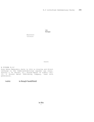
  • 1. 8.3 Lithified Sedimentary Rocks 299 Lake Michigan Wisconsin Illinois Scale: A FIGURE 8.12 Area where Maquoketa shale is thin or missing and direct recharge to the CambrianOrdovician aquifer can occur. Source: C. W. Fetter, Jr., Ground Water 79 (1981): 201— 13. O Ground Water Publishing Company. Used with permission. i«etric in theaq#r hasdèîlinèd in ibis thè
  • 2. 300 Chapter Geology of Ground-Water Occurrence 8 750 Potentiometric surface of Cambrian-Ordovician aquifer in southeastern Wisconsin and northeastern Illinois. A. About 1865—1880. B. In 1973. Source: C. W. Fetter, Jr., Ground Water 7 9 (1981): 207—13. © Ground Water Publishing Company. Used with permission. 8.3.1 Complex Stratigraphy The fact that a formation may change in lithology from one locality to another accounts for some of the difficulties associated with studies of sedimentary rock units. For example, a sandstone may grade into a shaly sandstone or siltstone, yet still have the same fossil fauna assemblage and the same stratigraphic nomenclature. The Eau Claire Formation of Cambrian age is a sandstone in east-central Wisconsin, but it grades into a shale and siltstone in northern Illinois. In Wisconsin, it has high conductivity and is an aquifer; in Illinois, it becomes a confining layer (Walton 1965; Schicht, Adams, & Stall 1976). Complex stratigraphy can be a very real hindrance to ground-water exploration. On the Hualapai Plateau of northwestern Arizona, the best potential aquifer is the stratigraphic sequence of sedimentary rocks in the Rampart Cave Member of the Muav Limestone Formation (Twenter 1962). Springs discharge from this member into the Grand Canyon along the flanks of the plateau. The Bright Angel Shale stratigraphically underlies the Rampart Cave Member of the Muav Limestone, causing the ground water to be perched (Figure 8.14). However, because these units were being deposited in a 800M 850k' A FIGURE 8.1 3
  • 3. transgressing sea, the various beds are interfingering. As a result, at some localities the Bright Angel Shale can be both above and below the Rampart Cave Member (Figure 8.15). Drillers in the area have had unsuccessful wells because they stopped drilling when the Bright Angel Unit Age Thickness (ft) Lithology Gravels, Basalt, Tuff esco ame ormat10 Tertia 0—1000 2 Manakacha Formation Wata omi i Formatio 250 200 Redwall Limestone 600-675 Temple Butte Formation n tvi Devon ian 400-450 1 Muav Limestone 800-1200 Bright Angel Shale 400— 450 apeats andstone Vrshnu Schist Precambrian EXPLANATION Sandstone- Shale Limestone Dolomite Chert Siltstone Gravel Igneous- Basalt-Unconformity Metamorphic Tuff A FIGURE 8.14 Stratigraphy of the Grand Canyon area. Source: P. W. Huntoon, Ground Water 15 (7 977): 426—33. © Ground Water Publishing Company. Used with permission.
  • 4. 302 Chapter Geology of Ground-Water Occurrence Bright Angel Shale A FIGURE 8.15 Interfingering of sedimentary rock units of the Hualapai Plateau area. Source: Adapted from P. W. Huntoon, Ground Water 15 (7 977): 426—33. © Ground Water Publishing Company. Used with permission. 301 8 Shale was first reached (Huntoon 1977). Unfortunately, the target formation had not yet been penetrated. A well drilled at Location A of Figure 8.15 would not hit Bright Angel Shale until the Rampart Cave Member was penetrated. However, at location B, three shale members alternating with limestone would have to be penetrated before the Rampart Cave Member was reached. The area of these interfingering members extends for tens of miles. The hydrogeologist working in areas of such complex stratigraphy must be aWare of the possible hydrogeologic consequences. 8.3.2 Folds and Faults Folding and faulting of sedimentary rocks can create very complex hydrogeologic tems, in which determination of the locations of recharge and discharge zones and flow systems is confounded. Not only must the hydrogeologist determine the hydraulic characteristics of rock •units and measure ground-water levels in wells to determine flow systems, but detailed geology must also be evaluated. In most cases, the basic geologic structure will have already been determined; however, logs of test wells and borings must be reconciled with the preexisting geologic knowledge. Fault zones can act either as barriers to ground-water flow or as ground-water conduits, depending upon the nature of the material in the fault zone. If the fault zone consists of finely ground rock and clay (gouge), the material may have a very low hydraulic conductivity. Significant differences in ground-water levels can occur across such faults (see Figures 8.9 and 8.10). Impounding faults can occur in unconsolidated materials with clay present, as well as in sedimentary rocks where interbedded shales, which normally would not hinder lateral ground-water flow, can be smeared along the fault by drag folds. Clastic dikes are intrusions of sediment that are forced into rock fractures. If they are clay-rich, they can act as ground-water barriers in either sediments or in a lithified sedimentary rock. Clastic dikes are known to occur in alluvial sediments, glacial outwash, and lithified sedimentary rock. Faults in consolidated rock units can act either as pathways for water movement or as flow barriers. If there has been little displacement along the fault, then the fault is more likely to develop fracture permeability because there is less opportunity for the formation of soft, ground-up rock, called gouge, to form between the moving surfaces (Huntoon 1986). Fault gouge can have a matrix of rock breccia encased in clay and can have a wider range of permeability (Snipes et al. 1986). Faults in poorly consolidated rocks in South Muav Limestone —
  • 5. Carolina had greater permeability than those in well-consolidated rocks (Snipes et al. 1986). If the fault zone has a high porosity and hydraulic conductivity, it can serve as a conduit for ground-water movement. Springs discharging into the Colorado River in Marble Canyon are controlled by a vertical fault zone, the Fence Fault. The springs discharge where the faults intersect the river. The fault zones provide for vertical movement of recharging ground water from the land surface as well as lateral movement toward the river. The geochemistry of the spring water indicates that some of the water discharging on one side of the river originated in the ground-water basin on the opposite side of the river, indicating the fault zone was conducting some ground-water flow beneath the river even though it is a regional discharge zone (Huntoon 1981). Faults may contain ground water at great pressures at depths where tunnels or mines may be constructed. One danger of hard-rock tunneling is the possibility of breaching an unexpected fault zone. Damaging and dangerous flooding can occur if the fault contains ground water with a high hydraulic head. In Utah, a well being drilled through an anticlinal structure, which in an unfaulted state creates a regional confining layer, encountered an exceptionally high-permeability zone created by normal faults and associated extensional joints that imprinted joint permeability on the brittle rocks. The well was being
  • 6. 304 Chapter 8 Geology of Ground-Water Occurrence Tertiary cover HOMOCLINAL MARGIN 5000 ft 15—60 miles MOUNTAIN UPLIFT 10,000 ft - SEVERED MARGIN Tertiary cover s ic roc PalQ0R9iç: rqqks FIGURE 8.16 Schematic cross section through a typical Wyoming mountain uplift showing the style of deformation that results in approximately equal percentages of fault severed and homoclinal basin perimeters. Source: P. W. Huntoon, Ground Water 23 (7 985): 7 76—81. C) Ground Water Publishing Company. Used with permission. drilled to initiate solution mining of an abandoned underground potash mine. Unfortunately, ground water under high pressure in the fracture zone rushed into the well boring when the mine level was reached and flooded it with mineralized water (Huntoon 1986). Overthrust faulting can create conditions in which a rock, normally found as an impermeable basement unit, is overlying the sedimentary rock units, typically a groundwater source. In such a case, the hydrogeologist might recommend drilling through the "basement" rocks to attempt to obtain a ground-water supply from younger sedimentary units, provided there is an opportunity for recharge to occur and the water is not known to have a high mineral content (Figure 8.16). The major artesian basins of Wyoming consist of sedimentary rock units bounded by major thrust faults. The fault-severed margins of the basins have good permeability, adequate recharge, and good-quality water in the sedimentary rock aquifers of the hanging wall. However, the foot-wall rocks receive little recharge, have poor-quality water, and have permeabilities often many orders of magnitude lower than those of the adjacent hanging wall segments of the same formation (Huntoon 1985). Is tog-round-V@ter flow, W p,
  • 7. 8.3 Lithified Sedimentary Rocks305 Ðtþrbekisunižotmlyfragturèdw1 depthÅåtRmoreextenFiÿe fractured-zones inthe rock LEGEND O PRODUCTION MONITORING WELL FAULT Eastern Fault Block North Main Cross-Fault Eastern P23 Fault Block T24 P22 Ml Central Il Fault Block Bl Cross-Fault T33 T31 Central I P21 Fault Block TORY P32 Eastern Fault Western o Fault Block rapids Central Fault 200m Western Fault scale A FIGURE 8.17 Locations of wells, faults, and fault blocks, Carlton University. Source: Allen, Diana M. and Frederick A. Michel. 1998. Ground Water 36. no. 6:938—948 © Ground Water Publishing Company. Used with permission. indicate theßyOf4@lt blocks ssivities. The centfrål zone zone had a transmissivitÿ bf aŽ56
  • 8. 306 Chapter 8 Geology of Ground-Water Occurrence Séne that 9.26 separates ft /daÿ (0.86 the mtwo 2 /daÿOaquifer þIoçksÁÅta' of Folding can affect the hydrogeology of sedimentary rocks in several ways. The most obvious is the creation of confined aquifers at the centers of synclines. The nature of the fold will affect the availability of water. A tight, deeply plunging fold might carry the aquifer too deep beneath the surface to be economically developed. Deeply circulating ground water is also typically warmed by the geothermal gradient and may be highly SIMPLIFIED STRATIGRAPHIC PROFILE ALONG THE LINE A-AI 60 mast 0 LEGEND shale siltstone sandstone 100limestone dolostone calcaren 200 SIMPLIFIED STRATIGRAPHIC PROFILE ALONG THE LINE B-B I 60 masl O 100
  • 9. 8.3 Lithified Sedimentary Rocks307 200 B A FIGURE 8.18 Stratigraphic cross sections across Carlton University campus. Cross section locations shown on Figure 8.16. Source: Allen, Diana M. and Frederick A. Michel. 7998. Ground Water 36. no. 6:938—948. © Ground Water Publishing Company. Used with permission. mineralized. A broad, gentle fold can create a relatively shallow, confined aquifer that extends over a large area. This might be a good source of water if sufficient recharge can occur through the confining layer or if the aquifer can transmit enough water from areas where the confining layer is absent. Another effect of folding is to create a series of outcrops of soluble rock, such as limestone, alternating with rock units that are not as permeable. Smaller streams flowing the limestone might sink at the upper end, only to reappear at the lower outcrop. The type of trellis drainage that can develop on folded rocks is shown in Figure 8.20. Surace streams follow the strike of rock outcrops, usually along fault or fracture traces. In •olded sedimentary rocks with solutional conduits in carbonate units, ground-water flow nay be along the conduits that parallel the strike of the fold and not down the dip. In areas of homoclinal folds, the outcrop areas usually have bands of sedimentary ocks, with resistant rocks forming ridges and more easily erodable rocks forming valleys.
  • 10. 308 Chapter 8 Geology of Ground-Water Occurrence A FIGURE 8.19 Static hydraulic head measurements in wells on Carlton University campus. Data from Allen, Diana M. and Frederick A. Michel. 1999. Ground Water 37. no, 5: 718—728. The ridges may create ground-water divides, with aquifers outcropping in the valleys. The outcrop area of an aquifer will have local water-table flow systems with relatively large amounts of water circulating. These areas also serve as the recharge zones for the more distal parts of the aquifer, which are downdip in the basin and confined. There is a limited amount of natural discharge from the confined portions of the aquifer, this is, typically upward leakage into overlying beds with lower hydraulic head. Because of poor groundwater circulation, the confined portions of the aquifer may have low hydraulic conductivity and poor water quality (LeGrand & Pettyjohn 1981). Complex folded and faulted sedimentary rock units are a challenge to the hydrogeologist. Competency in geology is necessary in order to construct geologic cross sections based on well logs, drill-core samples, and outcrops. Regional flow systems can be controlled by the structural and stratigraphic relations of the confining beds and aquifer units. In addition, distribution of hydraulic potential must be determined, very often from limited data.
  • 11. 8.3 Lithified Sedimentary Rocks309 FIGURE 8.20 Drainage pattern developed in an area of longitudinally folded rock strata: A. Top view. B. Cross section. Birds-eye view Fracture trace Cross section 8.33 Clastic Sedimentary Rocks Hydraulic conductivity of clastic sedimentary rocks, based on primary permeability, is a function of the grain size, shape, and sorting of the original sediment. The same factors that affect the permeability and porosity of loose sediments also are important in sedimentary rocks. Cementation, in which parts of the voids are filled with precipitated material such as silica, calcite, or iron oxide, can reduce the original porosity. Solution of the original material or cementing agent may occur during and after diagenesis, resulting in an increase in porosity. Consolidated rocks also contain secondary porosity and permeability due to fracturing. Microfractures may add very little to the original hydraulic characteristics; however, major fracture zones may have localized hydraulic conductivities several orders of magnihide greater than that of the unfractured rock. Fracturing can occur through several geoogic processes. Rock at depth is under great pressure owing to the weight of the )verburden. As uplift and erosion bring the consolidated rock to the surface, it expands as he pressure is reduced. The expansion can cause fracturing of the rock, o o o o o
  • 12. 310 Chapter 8 Geology of Ground-Water Occurrence with the majority the expansion fractures occurring within about 300 ft (100 m) of the surface. Vertical ractures carry recharging precipitation downward and provide a very important function n bypassing low-permeability layers near the surface. Wells located in surface fracture ones are generally highly successful. c A FIGURE 8.21 Sedimentary conditions producing a sandstone aquifer of variable thickness: A. Sandstone deposited in a sedimentary basin. B. Sandstone deposited unconformably over an erosional surface. C. Surface of sandstone dissected by erosion prior to deposition of overlying beds. Fracturing may also be associated with tectonic activity. Rock deformed by faulting or folding may fracture when subjected to tension or compression. Such activity can take place at substantial depths; thus, secondary permeability is not strictly a near-surface phenomenon. However, great pressure on the deeper fractures does not permit them to be as open (have as great a porosity) as shallow fractures. The yield to wells is proportional to the transmissivity of the aquifer. This, in turn, is proportional to the aquifer thickness if the hydraulic conductivity is uniform throughout the aquifer. Sedimentary aquifers were deposited in sedimentary basins in which units gradually thicken. Variable thickness of a sedimentary aquifer may also be due to the deposition of the aquifer material over an eroded surface with high relief or a dissection of the top of the aquifer after deposition (Figure 8.21). Higher well yields will be obtained from thicker sections of the aquifer. The relationship between the specific capacity of wells and the uncased thickness of two sandstone aquifers in northern Illinois is shown in Figure 8.22. Wells in sandstone aquifers should be located in such a manner as to penetrate the maximum saturated thickness of the aquifer. If one area of the aquifer is known to have a higher hydraulic conductivity than other areas, the combination of hydraulic conductivity and Sandstone
  • 13. 8.3 Lithified Sedimentary Rocks311 thickness should be considered in order to locate the well in the area of greatest aquifer transmissivity. The yield of sandstone wells can sometimes be increased by the detonation of explosives in the uncased hole. The shots are generally located opposite the most permeable zones of the sandstone. The loosened rock and sand is bailed from the well prior to the installation of the pump. The shooting process has two effects on the borehole: it enlarges