
Recommended
More Related Content
Similar to 10 Best Hikes in Olympic National Park.pdf
Similar to 10 Best Hikes in Olympic National Park.pdf (20)
Recently uploaded
Recently uploaded (19)
10 Best Hikes in Olympic National Park.pdf
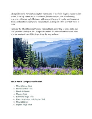
- 1. Olympic National Park in Washington state is one of the most magical places on the planet, boasting snow-capped mountains, lush rainforests, and breathtaking beaches – all in one park. However, with so much beauty, it can be hard to narrow down the best hikes in Olympic National Park, as the park offers over 600 miles of trails. Here are the 8 best hikes in Olympic National Park, according to some polls, that take you from the top of the Olympic Mountains to the Pacific Ocean coast—and provide plenty of incredible views along the way. so here. Best Hikes in Olympic National Park 1. Mount Storm King 2. Hurricane Hill Trail 3. Hoh Rain Forest 4. Maiden Peak 5. Klahhane Ridge Trail 6. Rialto Beach and Hole-in-the-Wall 7. Mount Ellinor 8. Skyline Ridge Trail
- 2. 9. Ozette Triangle Loop Trail 10. High Divide Trail & the Seven Lakes Basin Loop 1. Mount Storm King ● Distance: 4.65 miles | Difficulty: Strenuous | Total Ascent: 2,130 feet | Time: 3 to 5 hours Mount Storm King
- 3. Mount Storm King is a mountain located within the Olympic National Park about 20 miles west of Port Angeles, Washington. It has an elevation of 4,500+ feet (1,370+ m) and is located on the south side of Lake Crescent near Barnes Point. The trail to the summit starts near the Storm King Ranger Station and initially follows the trail to Marymere Falls but branches to the north after a short distance. The first 1.9 miles (3.1 km) is on a maintained trail but the rest of the climb involves scrambling on rocks. The summit offers great views of Canada, Juan de Fuca Strait, and Crescent Lake. The climb to the summit can be dangerous in bad weather, and hikers are advised to be cautious. Tips: Climbing the summit can be dangerous in bad weather, and hikers are advised to remain cautious. Hikers should wear sturdy and grip-supportive hiking shoes, bring plenty of water and some snacks, and come ready for a workout. Going in early spring or late autumn will help avoid crowds and reduce human impact on the trails. Pedestrians should also check trip reports to see what they are doing. 2. Hurricane Hill Trail
- 4. Difficulty: Easy to moderate | Duration: 41 Minets | Lenth: 17.4 Miles Roundtrip | Elevation Gain 650 Fit | Highest Point: 600 Fit. Hurricane Hill Trail
- 5. Hurricane Hill is one of the most bang-for-your-buck hikes I’ve done- EVER- and one of the most unmissable stops you need to add to your Olympic National Park itinerary. Once you drive your car up and literally on top of Mount Angeles to the trailhead, the trail will lead you along its ridge, with jaw-dropping views of the Bailey Range of the Olympic Mountains in every direction that will have you singing the Sound of Music soundtrack. Along the path, you’ll have opportunities to see technicolor wildflowers (if you’re visiting in the summer); abundant furry friends, like mountain goats or blacktail deer; and, on a clear day, views all the way to the beautiful Vancouver Island, Canada. Tips The Hurricane Hill Trail is a popular hiking trail in Olympic National Park, Washington, offering stunning views of the Olympic Mountains and the interior of
- 6. the Olympic Range. Here are some tips for hiking the trail based on the search results: The trail is an out-and-back hike that begins 1.5 miles past the Hurricane Ridge Visitor Center It is a 1.6 to 3.2-mile roundtrip trail, with a paved surface, making it an easy to moderate hike depending on your fitness level The trail offers panoramic views of the Olympic Range, the Elwha River Valley, the Bailey Range, the town of Port Angeles, the Strait of Juan de Fuca, and occasionally Vancouver Island Be sure to dress accordingly and take along water as there is little shade along the way Watch for wildlife along the way, and during summer, watch and listen for the whistle of marmots The trail is known for its beautiful wildflowers during July and is a Great hike for a summer sunset The trail is suitable for beginners, families with kids, and even hikers using wheelchairs for the first quarter mile These tips should help you prepare for an enjoyable hike on the Hurricane Hill Trail, allowing you to make the most of the stunning scenery and unique features of the trail 3. Hoh Rain Forest Difficulty: Strenuous | Duration: 6 - 8 hours | Lenth: 17.4 Miles Roundtrip | Elevation Gain 2493 Fit | Highest Point: 600 Fit.
- 8. The Hoh Rainforest is one of the largest temperate rainforests in the U.S., located on the Olympic Peninsula in western Washington state. It is the wettest forest in the Contiguous United States, receiving over 100 inches of rain per year, with as much as 14 feet of rain a year, and an additional 30 inches from prevalent fog and mist. The forest is characterized by a deep layer of vegetation, and its ecosystem is home to many endangered species, such as Spotted Owls, Marbled Murrelets, fishers, salmon, and Bull Trout. The Hoh Rainforest is protected from commercial exploitation within Olympic National Park, and it is an example of a temperate rainforest, similar to tropical rainforests in terms of high rainfall and lush vegetation Tips The Hoh Rainforest, located in Olympic National Park, is a majestic and lush destination offering a unique experience for visitors. Here are some tips for exploring the Hoh Rainforest based on the provided information.
- 9. Best Time to Visit: To experience the tranquility of the rainforest with fewer crowds, consider arriving early in the morning, ideally by 8:30 a.m. or 9 a.m. This can allow you to have the trail largely to yourself for a more immersive experience Accommodations: If you plan to visit for a day hike, consider staying overnight in the nearby area, such as in Forks or at an Airbnb or camping spot, to ensure an early start and maximize your time in the rainforest Trails to Explore: The Hoh Rainforest features several trails, including the Hall of Mosses Trail, the Spruce Nature Trail, and the Hoh River Trail. The Hall of Mosses Trail, in particular, is a popular choice for its enchanting greenery and unique atmosphere What to Bring: Given the high rainfall in the area, it's recommended to wear waterproof footwear and a good rain jacket. Additionally, adhering to the principles of Leave No Trace is important to help preserve the forest's pristine condition Wildlife and Nature: The rainforest is home to a diverse range of wildlife, including marbled murrelets, northern spotted owls, otters, deer, and Roosevelt elk. As you explore, take the time to observe and respect the natural environment and its inhabitants By keeping these tips in mind, you can make the most of your visit to the Hoh Rainforest and fully appreciate its natural beauty and tranquility. 4. Maiden Peak
- 10. Difficulty: Strenuous | Duration: 6 - 8 hours | Lenth: 28.6 Miles Roundtrip | Elevation Gain 956 Meter | Highest Point: 6,020 Fit.
- 11. Maiden Peak is the highest point in the 43-mile distance between Mount Bachelor and Diamond Peak in central Oregon. It is a steep-sided shield volcano with an elevation of 7,823 feet (2,384 m) and is located on the Cascade Crest, serving as the boundary between Lane County and Deschutes County. The summit of Maiden Peak consists of a steeper cinder cone that sits atop the underlying shield. The mountain features a 5.8-mile trail that leads to the summit from the southwest, and it was the site of a Forest Service fire lookout tower built in 1923 and removed in 1958 Tips When planning to hike Maiden Peak, consider the following tips: Choose the right trailhead: Different trailheads lead to Maiden Peak, such as the Maiden Lake Trailhead And the Deer Park Trailhead Research the various options and select the one that best suits your preferences and skill level.
- 12. Bring necessary gear: Pack plenty of water, sun protection, and other essentials for your hike. It's essential to be prepared for the elements, especially if you're hiking in the Washington state version of Maiden Peak, which experiences more precipitation Follow the trail: Stick to the designated trail and avoid shortcuts or faint boot paths, as they can be dangerous and damage the environment Be cautious around cliffs: Maiden Peak in Olympic National Park has cliffs on the north to northeast side. Exercise caution when hiking near these areas 5. Enjoy the views Once you reach the summit, take the time to enjoy the panoramic views of the surrounding area, including the Olympic Mountains, Grand Lake, and Grand Valley Consider the season: Maiden Peak in central Oregon is part of the Central Oregon Six-Pack of Peaks Challenge, which is a series of hikes with a combined elevation gain of 10,000 feet. This challenge is particularly strenuous and may not be suitable for everyone, so consider your fitness level and experience before attempting it 5. Klahhane Ridge Trail Difficulty: Advanced | Duration: 6 - 8 hours | Lenth: 5.0 Miles Roundtrip | Elevation Gain 17,00 Fit | Highest Point: 6,020 Fit.
- 14. Claheen Ridge is a hiking trail located in Olympic National Park near Port Angeles, Washington, United States. The ridge can be accessed from four different directions. The shortest and most direct route is the Switchback Trail. Which gains 1,700 feet of elevation in 1.5 miles. The path begins to climb through switchbacks through a sub-alpine, coniferous forest and then reaches meadows filled with colorful wildflowers in the summer. The ridge offers 360-degree views of the Strait of Juan de Fuca to the north, the interior Olympic Mountains to the south, and sub-alpine beauty everywhere in between. The hike to the summit of Mount Angeles is a great day hike that ends with some difficult rock climbing, but hikers are rewarded with 360° views from the summit of Mount Angeles, the highest point in the Hurricane Ridge area. There is a high peak. Tips It is advisable to check trip reports and be mindful of limited parking and potential wait times. Proper trail etiquette, such as proper disposal of trash and being considerate of other pedestrians, should be followed. If you're hiking to the summit
- 15. of Mount Angeles, be prepared for some tough rock climbing, but the 360° view from the summit is a rewarding experience. 6. Rialto Beach and Hole-in-the-Wall Difficulty: Advanced | Duration: 6 - 8 hours | Lenth: 19.0 Miles Roundtrip | Elevation Gain 4,000 Fit | Highest Point: 5,120 Fit.
- 16. Rialto Beach is located in Olympic National Park in Washington state and is known for its scenic beauty and unique rock formations. One of the notable attractions at Rialto Beach is the Hole-in-the-Wall, a rock formation with Swiss-cheese holes and clefts sculpted by ancient volcanic eruptions The hike to the Hole-in-the-Wall from Rialto Beach is approximately 1.5 miles and offers stunning coastal views, wildlife sightings, and the opportunity to explore tide pools when the tide is low The tide needs to be low enough to safely access the Hole-in-the-Wall, and a tide of 1.17 feet is considered low enough for this hike. Tips
- 17. Rialto Beach and Hole-in-the-Wall in Olympic National Park offer a stunning coastal hike with a unique rock formation accessible at low tide. Here are some tips for visiting. Check the Tide Tables: It's essential to check the tide tables for the day of your visit and plan to arrive well before low tide to access the Hole-in-the-Wall rock formation Wear Appropriate Gear: Good hiking shoes are recommended, as the hike involves walking on soft sand and navigating over rock formations. Be prepared to get a little wet and dress for the weather Parking and Hiking: Parking at Rialto Beach can be limited, especially at low tide, so it's advisable to arrive early. The roundtrip hike to the Hole-in-the-Wall is about 3.3 miles, and the soft sand can make it seem longer. Plan your hike to reach the rock formation near low tide to allow time for exploration before the tide comes back in. 7. Skyline Ridge Trail Difficulty: Advanced. Duration: 6 - 8 hours return. Distance: 24 km return. Elevation Gain: 700 meters. Seasonality: Summer
- 18. The Skyline Ridge Trail is a hiking trail located in various locations in the United States and Canada. In Olympic National Park, the Skyline Ridge Primitive Trail is a challenging 54.5-mile trail near Quinault, Washington. The pass becomes narrower and steeper as it continues north, following the ridgeline toward the Kimta Peak Basin.
- 19. In Nova Scotia, the Skyline Trail is a hiking path that leads up a steep headland cliff overlooking the Gulf of St. Lawrence and the Atlantic Ocean. It's breathtaking and includes the Cabot Trail, Presqueville and Cheticamp Islands In the Bay Area, the Skyline Ridge and Russian Ridge Open Space Preserves offer hikes through open grasslands to high ridges with gradual elevation gain and loss. The route consists of narrow hiking trails and wide farm roads over marshy land. Tips Skyline Ridge Open Space Preserve and Skyline Loop Trail are popular hiking destinations, offering beautiful views and diverse landscapes. Here are some tips for hiking these trails. Skyline Ridge Open Space Preserve: Located in California, this preserve offers various trails, with the best one being Horseshoe Lake - Alpine Pond - Borel
- 20. The trail is open to hikers only and begins in grassland before entering a woodland of Douglas fir, coast live oak, and big-leaf maple. Skyline Loop Trail at Mount Rainier: This trail is located in Mount Rainier National Park and offers a 5.5-mile loop with an elevation gain of 1,700 feet The trailhead is located at the Paradise parking lot in Mount Rainier National Park The trail is considered moderate to hard in difficulty and is not dog-friendly To reach the trailhead, you need to take the Paradise Shuttle or Longmire Shuttle from the Paradise parking lot The trail offers incredible views of the south and is a popular choice among hikers Skyline Ridge Primitive Trail in Olympic National Park: This trail is located in Olympic National Park and features rock cairns to aid in navigation through the alpine area The trail is a 1-mile loop with bear canisters required for food storage due to the lack of good trees for hanging food Camp in established sites or on bare ground, and practice Leave No Trace principles to protect vegetation and other park resources When planning your hike, consider the season, difficulty, and trailhead location to ensure a safe and enjoyable experience. Always follow Leave No Trace principles and stay on designated trails to protect the environment and local wildlife. 9. Ozette Triangle Loop Trail Difficulty: Advanced | Duration: 6 - 8 hours | Lenth: 9.4 Miles Roundup | Elevation Gain 100 Fit | Highest Point: 350 Fit
- 21. Ozette Triangle Loop Trail
- 22. The Ozette Triangle Loop Trail, also known as the Cape Alava Loop, is a 9.4-mile loop trail located in Olympic National Park, Washington. It offers a combination of a forest stroll and a walk on the beach, making it a diverse and scenic hiking experience. The trail starts at Lake Ozette, the largest unaltered natural lake in Washington, and includes a section along the coast where hikers can enjoy sea lion sightings, otter frolics, and eagle watching. The trail is generally considered moderately challenging and is a popular choice for hikers and backpackers looking to explore the natural beauty of the area For more detailed information about the trail, including maps, camping permits, and trail conditions, hikers are advised to visit the official Olympic National Park website and the Washington Trails Association website. Additionally, it is recommended to check the trail conditions and read trip reports before embarking on the hike Ozette Triangle Loop Trail for Tips The Ozette Triangle Loop Trail is a hike in Olympic National Park that offers a combination of forest strolls and beach walks The trail is 9.4 miles long and can be hiked in a single day, but it can also be enjoyed as a multi-day backpacking trip Some key aspects of the Trial include: Trailhead: The trailhead is located at Lake Ozette, which is the largest unaltered natural lake in Washington Cape Alava Trail: The hike starts with the Cape Alava Trail, which takes you out to the beach and back for a 6.2-mile hike Sand Point Trail: To make the loop longer (9.4 miles), you can continue south along the beach and connect with the Sand Point Trail Camping: The trail offers great camp spots strategically located along the coastline, making it suitable for multi-day hikes
- 23. Seasonality: The trail is accessible all year round, unlike many other trails in Washington State that are covered in snow during winter Before embarking on the hike, it is essential to check the trail conditions on the Olympic National Park website and read trip reports on the Washington Trails Association website There is no public transportation to the trailhead, so you will need to drive yourself It is also crucial to be aware of potential encounters with wildlife, such as mountain lions, especially during the night. 10. High Divide Trail & the Seven Lakes Basin Loop Difficulty: Advanced | Duration: 6 - 8 hours | Lenth: 19.0 Miles Roundtrip | Elevation Gain 4,000 Fit | Highest Point: 5,120 Fit.
- 25. The High Divide Trail and the Seven Lakes Basin Loop are located in Olympic National Park and offer a stunning 19-mile round-trip hike with about 4,000 feet of elevation gain The trail takes you through four ecosystems: old-growth forest, subalpine meadow, subalpine lake basin, and montane forest Some key features of the trail include: Seven Lakes Basin: A formerly-glaciated mountain lake basin at the headwaters of the Sol Duc River There are eight small lakes and numerous tiny ponds in the area, including Sol Duc, Long, Lunch, Morgenroth, No Name, Clear, Round, and Lake No.
- 26. High Divide Loop: A 19-mile loop trail that starts by following the Sol Duc River near Sol Duc Hot Springs, traverses south past Sol Duc Falls and then begins a rapid elevation gain to arrive at the basin The loop trail offers views across the Hoh Valley to Mt. Olympus to the south Wildlife: The area is home to various wildlife, such as black bears, marmots, black-tailed deer, mountain goats, and small brook trout Camping: Camping is limited and requires reservations up to 6 months in advance via Recreation.gov There are several campgrounds and campsites along the trail, with the most sought-after sites being Heart Lake and Lunch Lake Difficulty: The trail is generally considered moderate in difficulty, with an elevation gain of 3,050 feet The High Divide Loop and Seven Lakes Basin offer a diverse and picturesque hiking experience, making it a popular destination for backpackers and nature lovers alike. High Divide Trail & the Seven Lakes Basin Loop For Tips The High Divide Trail, also known as the Seven Lakes Basin Trail, is a popular backpacking route in Washington, offering a diverse range of landscapes and stunning views. The trail is approximately 18.3 miles long and gains 3,050 feet in elevation, with a difficulty level rated as moderate To make the most of your experience, consider the following tips: Best time to go: The best time to hike the High Divide Trail is from mid-July to mid-October. May, June, and the beginning of July may have a chance of snow, while September and October are great for spotting fall colors, although the weather might be less predictable Permits: Due to the trail's popularity, a permit is required for overnight stays. You do not need a permit for day hiking
- 27. Water: There is no water between Heart Lake and Lunch Lake in the early summer. By the time most hikers reach this section, the snow has usually melted, but you should still fill up all your water reservoirs before starting the trail Weather: Be prepared for a variety of weather conditions, as the trail passes through four ecosystems: old-growth forest, subalpine meadow, subalpine lake basin, and montane forest Views: The trail offers breathtaking views of the Seven Lakes Basin, Mount Olympus, and other stunning landscapes. Take your time to soak in the scenery and enjoy the tranquility of the area Side trips: Consider taking side trips to Lunch Lake or Bogachiel Peak along the way for additional views and experiences Camping: There are several private spots along the trail for camping, but they can be crowded. Plan your camping locations in advance and consider alternative options if your preferred spot is taken Remember to follow Leave No Trace principles and respect the natural environment when hiking the High Divide Trail and Seven Lakes Basin Loop.