Impacts of Sea Level Rise on Maritime Boundaries
•Download as PPT, PDF•
1 like•678 views

Sea levels are rising faster than previously estimated, which could significantly impact maritime jurisdictional limits and sovereignty over offshore areas. As sea levels rise, coastal baselines and the limits measured from them will shift inland. This may reduce the size of countries' exclusive economic zones and cause islands to be reclassified, impacting maritime claims. Nations could build defenses to preserve coastlines, fix baselines legally through charts, or fix their maritime limits, but these options all pose challenges for balancing certainty of claims with changing physical coastlines. Significant implications could include loss of jurisdiction over resources, boundary disputes, and conflict.

Recommended
Recommended
More Related Content
Viewers also liked
Viewers also liked (18)
Similar to Impacts of Sea Level Rise on Maritime Boundaries
Similar to Impacts of Sea Level Rise on Maritime Boundaries (20)
More from Iwl Pcu
More from Iwl Pcu (20)
Impacts of Sea Level Rise on Maritime Boundaries
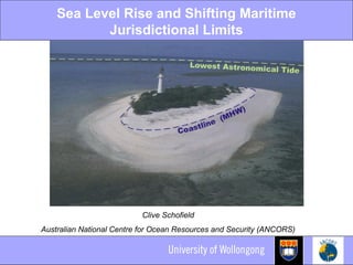
- 1. Sea Level Rise and Shifting Maritime Jurisdictional Limits Clive Schofield Australian National Centre for Ocean Resources and Security (ANCORS)
- 2. Sea Level Rise • IPCC’s estimated range of sea level rise: 0.38- 0.59m by the end of the century? • Growing consensus that this estimate is overly conservative • Great uncertainty over the critical questions of how much and how quickly?
- 3. Maritime Jurisdictions Zones The Area 200 M Sea Level 12 M Contiguous zone Territorial sea 12 M Exclusive Economic Zone (EEZ) Water Column, Sea-bed, Subsoil Rise Deep Ocean Internalwaters TerritorialSeaBaseline (Extended Continental Shelf) Continental Shelf Sea-bed, Subsoil, Sedentary Species High Sea Shelf Lower Slopemadeandi@ugm.ac.id © 2008 Upper Slope Plateu or Terrace
- 4. Migrating Baselines = Shifting Limits • Maritime jurisdictional limits measured from baselines: Predominantly normal baselines, low-water line baselines • Traditional interpretation: ambulatory baselines and consequently shifting limits Coastlines dynamic – low water line susceptible to change As normal baselines move, the limits drawn from them also shift • Not a new phenomenon • As sea level rises so the low-water line migrates inland • Dramatic horizontal shifts to normal baselines possible from slight changes to sea level vertically
- 5. Impacts on Islands • Sea level rise/shifting baselines will also impact on the classification of insular features • Most common normal baseline used, Lowest Astronomical Tide (LAT) – a very low low water line • Critical basepoints may be unstable or ephemeral insular features Vulnerable to sea level rise leading to downgrading of islands to mere rocks or low-tide elevations Impact on capacity to generate claims to maritime jurisdiction
- 6. Implications • Implications for: Extent and limits of maritime claims Enforcement issues Delimitation of maritime boundaries • Loss of jurisdiction over vital marine resources • Jurisdictional uncertainty • Potential for conflict
- 7. Potential Responses • Fix normal baselines physically Can key basepoints be preserved through sea defences, ‘building-up’ and/or reclamation? Long tradition and an option for critical basepoints but unrealistic for long coastlines? • Fix normal baselines legally • Fix the limits of maritime zones
- 10. Okinotorishima
- 11. Physical defences unrealistic for long coastlines?
- 12. Fix Normal Baselines Legally • Choice of chart depicting normal baseline left up to the coastal State (LOSC, Article 5) • Chart the legal document • Can a coastal State therefore choose a chart that is advantageous to it? What if there is a difference between the low water line shown on the chart and reality? • The drafters of the Convention did not anticipate sea level rise • BUT: Ambulatory baselines may be fixed with straight baselines on unstable coasts Connection to the low water line still required
- 13. Fixing Limits and Boundaries • Once agreed maritime boundaries remain fixed even though the baselines used to construct them may regress What if the territory in question disappears entirely? • The outer limits of the continental shelf may also be fixed as “final and binding” • Fix (declare) maritime limits Provides the advantage of certainty and the preservation of existing maritime claims BUT: Increasing tension between fixed limit and receding or disappearing normal baseline it is measured from
Editor's Notes
- <number>