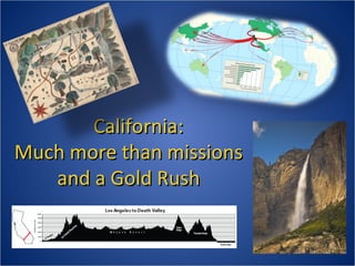
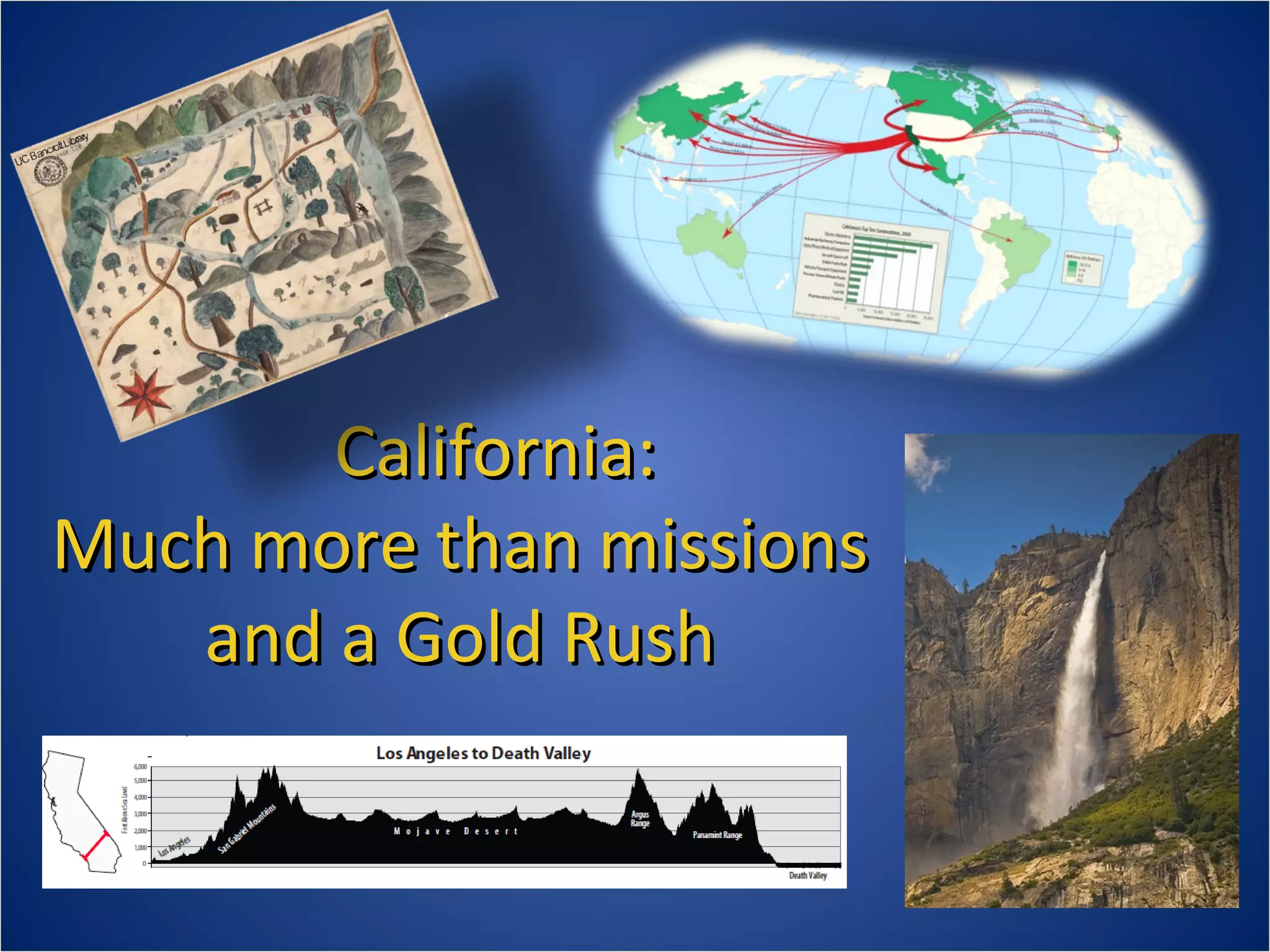
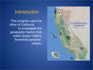
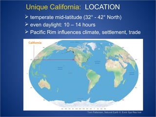
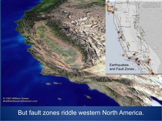
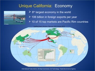
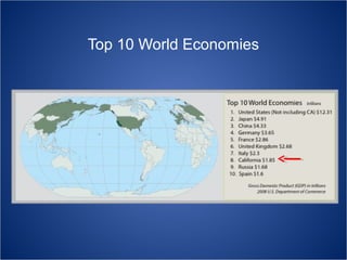
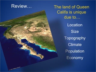
California:
Much more than missions
and a Gold Rush
Naming
California

California as an Island: circa 1650, Johannes Vingboons

Know that to the right hand of the Indies exists an island called California,
very near the Terrestrial Paradise... And there ruled over that island a
queen of majestic proportions, who accomplished great deeds. She was
valiant and courageous and ardent with a brave heart—Queen Califa.
García Ordóñez de Montalvo (1510)
Introduction
This program uses the
Atlas of California
to investigate the
geographic factors that
make Queen Califa’s
“terrestrial paradise”
unique.
What makes the land
of Queen Califa
unique?
What makes the land
of Queen Califa
unique?
Location
Size
Topography
Climate
Population
Economy
Unique California: LOCATION
 temperate mid-latitude (32° - 42° North)
 even daylight: 10 – 14 hours
 Pacific Rim influences climate, settlement, trade

Tom Patterson, Natural Earth II; Evnir Sys Res Inst
CA Geol Survey; UC
Seismological Lab; NorCal
Earthquak Catalog; USGS

Earthquakes
and Fault Zones

But fault zones riddle western North America.
Tom Patterson, Natural Earth II; Evnir Sys Res Inst

The first Californians crossed the Bering Straits from Asia, then traveled south
along the Pacific Rim. Others may also have crossed the Pacific Ocean.
The Spaniards were the first Europeans to reach California when Juan Rodriguez
Cabrillo arrived in San Diego by ship in 1542. In 1769, they established San Diego
de Alcala, the first non-native settlement. American fur trappers entered California
overland from the east during 1820s, at the height of the Mission Period.
WAN Conservancy

Cabrillo Arrives ~ 1542
Unique California: Size

 100 million acres:
3rd after AK and TX
 800 miles long
 250 miles wide
These 100 million acres
provide tremendous
diversity of …

Land Cover

 Topography
 Climate
 Plants
 Animals
 Opportunities for
human settlement
North to South
East to West
In Rainshadows

UC Davis

More than any other area of comparable size in North America
Unique California: Topography

 divided into mountains & valleys
 exceeds 14,000 ft. ~ drops 200 ft. below sea level
 coastline of rocky headlands and broad beaches
There are 12
Physiographic
Regions
Physiography
the shape of the land
surface
Low physiographic diversity
FL, OK, IA
High physiographic diversity
AK, CA, VA
Atlas of California (1979)
The Klamath Mountains dominate sparsely
populated northwestern California.
Mt. Shasta (14,162’) and Mt. Lassen (not shown) are the southern
terminus of the Cascade Range that stretches north to Oregon and
Washington, and includes Mts. Hood, St. Helens, and Rainier.
Goose Lake on the Modoc Plateau is one of many saline lakes in
eastern California with no outlet to the sea. Evaporating water leaves
salt and other minerals behind.
Chamoismoon.com

Rocky headlands and coarse sand beaches typify California’s north
coast. Stinson Beach is one of many barrier beaches that block the
mouth of Coast Range streams in summer. In winter, rain-filled
lagoons combined with pounding surf reopen the channels.
Mountains cloaked in oak and chaparral rise above fertile
valleys of the Northern and Southern Coast Range.
Johnson (1971)

The Sierra Nevada is the geologic backbone of California, and separates
the Great Central Valley from the Basin & Range. The range tilts westward,
is 400 miles long and between 40-80 miles wide.
Although popular for winter recreation, the Sierra snowpack is a
water reservoir for cities and fields throughout lowland California.
Great Central Valley

This 400-mile long valley—the most level part of California—
is the most productive agricultural region in the world. A
network of canals, aqueducts, and pumps sustains fields and
livestock. San Francisco Bay is the only outlet to the sea.
The Basin & Range stretches from eastern
California to the Rocky Mountains. There is
no outlet to the sea.
Death Valley is the lowest (-282 ft.) and
hottest location in the Mojave Desert.
The Transverse and Peninsular Ranges separate the coastal plains
of Southern California and San Diego from the Mojave and Sonoran
Deserts. The red line is the boundary with Mexico.
Mojave Desert

Mt. San Gorgonio (11,501’)

The Transverse Ranges stretch from the Santa Monica Mountains to
the San Gabriel and San Bernardino Mountains, and bisect the
Southern California coastal plain from the Mojave Desert.
Arid winds from the interior Mojave Desert rush through low gaps
in the Transverse Ranges, then flow across Southern California’s
densely populated coastal plains.
J. Zorn

Periodic fires are a natural part of the chaparral life cycle.
Unique California: Climate
 Mediterranean climate covers only 2% of world
 unreliably wet winters ~ reliably dry summers
 mountains catch moisture for parched lowlands

Grabov Rat; F. DiCastri, Goodall, Specht (1981)
Annual Precipitation
Most precipitation falls in a
giant horseshoe-shaped ring
of mountains that surround
the Sacramento Valley.
This includes the northern
Coast Range, Klamath and
Trinity Mountains, Mt. Shasta
and Lassen Peak, and the
northern Sierra.
Over 90% of the moisture
falls during the winter months
as rain or snow in the higher
elevations.
PRISM © 2010
California
precipitation decreases:
North to South
West to East
In rainshadows on
the leeward sides
of mountains
North to South
East to West
In Rainshadows
Pearson Education/Cummings (2003)

The windward west side of the Sierra Nevada blocks Pacific storms,
leaving the Great Basin in an arid “rainshadow.”
Precipitation Transect: Sierra Nevada Rainshadow
San Francisco: 21”
Sacramento: 17”
Auburn: 40”
Blue Canyon: 60”
Donner Summit:
70”
Truckee: 25”
Reno: 7”
Ely: 3”

Elevation Profile
Mountains catch and retain moisture…

July snowpack at Tioga Pass, Yosemite
… for transport to cities and farms—80% of
California water goes to crops and livestock.

The Los Angeles Aqueduct carries water
south from the eastern Sierra Nevada.
Hydrology before human settlement.
Spring rains and melting snow once flooded the Central
Valley (right). The meandering Sacramento and San
Joaquin Rivers would overflow to form an enormous
seasonal swamp 4 million acres in size. Today, less
than 10 percent of these wetlands remain, but much
of that water now irrigates crops and livestock.

Irrigation Growth

CA Dept Water Res

Bowen
(1979)
Unique California: Population
 most diverse native populations in the Americas
 26% of present Californians were born outside the USA
 now the most diverse large-population in world history

Homeland Security; CA Public Policy Inst; INS Stat Yrbk; CA Dept Finance Legal Imm Summary
Settlement History

California’s varied
landscapes were home
to the greatest density
and diversity of
indigenous people in
the New World.

UC Publ.AmArch.and Ethn, V 38; Atlas CA (1979); CA
Patterns (1983); UC CA Indian Lib. Coll.
The Gold Rush was the epic and lasting
immigration event—one that proved rare
in world history
Enduring impacts
Native decline
Global immigration

Univ.
California

CA statehood
County boundaries
Wildlife decimation
Sedimentation
Hg in SF Bay/Delta
US Postal Service
California’s
58 Counties
The initial Gold Rush
and Bay Area
counties are smaller
because mountain
terrain and water
bodies made travel
and communication
difficult.

Population Division Estimate, US Census (2008)
Settlement History
 after the Gold Rush, 4 of 5 lived between SF and the Sierra foothills
 after WWII & the 1960’s baby boom, CA topped USA in population
 since 1990, domestic out-migration has exceeded in-migration
Post Gold Rush

Post
Baby Boom

Century Population
Change

1860 ~ 1960

US Census (2000)
US Census (2000)
Latin America is currently the largest area of origin for new Californians.

Pearson Education (2005)
As foreign immigration grows, native Californians dwindle.
Annual Net Domestic Migrations: 2000 --2004
Annual Net Domestic Migrations: 2000 2004
Incoming domestic
immigration

Outgoing domestic
immigration
Southern California is among the most diverse
places on Earth.
Century Change
In 1900 Bodie was one of the largest towns in eastern
California. A century later 99 percent of its residents
had moved on…
... while Los Angeles blossomed into the largest
North American Pacific Rim city.
Unique California: Economy
 8th largest economy in the world
 106 billion in foreign exports per year
 10 of 15 top markets are Pacific Rim countries
J. Cunha

International Trade Admin; US Dept Commerce; CA Technology, Trade &Commerce Agency
Top 10 World Economies
Silicon Valley is
the nerve center
of Digital Age
innovation.

Stanford University
Manufacturing a Future?
 currently shedding manufacturing jobs
 jobs going to Latin America and Asia
 high technology remains productive and promising

A Televisa crew in Mexico City
records on aaMacBook
records on MacBook
International Trade Admin; US Dept Commerce; CA Technology, Trade & Commerce Agency
Agricultural Exports of California
and the Top 15 Importing Countries

UC Agric Issues Center (2009)

California is the fifth largest provider of food in the world.
In 2006, California international agricultural
exports totaled 9.8 billion dollars.

Nuts to Iran (from Chico), via
the United Arab Emirates

UC Agric Issues Center (2009)
Prof. Wm. Bowen

Sustained by irrigation from mountain snow and groundwater,
the Great Central Valley is the most productive agricultural
region in the world.
R. Campbell

Sacramento Valley rice fields

Provide habitat for waterfowl
But our agricultural lands
are succumbing to
urbanization.
Central Valley urban centers:
Are replacing croplands
Will eventually rival So Cal
Increase regional temperatures
Provide more affordable housing
Use much less water than crops

Farmland Mapping & Monitoring Pgm; CDC; CDF; CDWR
Review…

The land of Queen
Califa is unique
due to…
Location
Size
Topography
Climate
Population
Economy
For more on
California geography
refer to:
calgeography.org
California:
Much more than missions and a Gold Rush
~~~~

The California Atlas was produced by the California Geographic
Alliance with generous support from:

Education Foundation

Author: Stephen F. Cunha, Ph.D.
Supervising Editors: Roni Jones and Emily Schell, Ed.D.
Cartography: Institute for Cartographic Design, Humboldt State University
Cartography Team Director: Mary Beth Cunha, M.A.
Administrative Manger: Mary Hackett

California Geography Introduction with the California Atlas

  • 1.
    California: Much more thanmissions and a Gold Rush
  • 2.
    Naming California California as anIsland: circa 1650, Johannes Vingboons Know that to the right hand of the Indies exists an island called California, very near the Terrestrial Paradise... And there ruled over that island a queen of majestic proportions, who accomplished great deeds. She was valiant and courageous and ardent with a brave heart—Queen Califa. García Ordóñez de Montalvo (1510)
  • 3.
    Introduction This program usesthe Atlas of California to investigate the geographic factors that make Queen Califa’s “terrestrial paradise” unique.
  • 4.
    What makes theland of Queen Califa unique?
  • 5.
    What makes theland of Queen Califa unique? Location Size Topography Climate Population Economy
  • 6.
    Unique California: LOCATION temperate mid-latitude (32° - 42° North)  even daylight: 10 – 14 hours  Pacific Rim influences climate, settlement, trade Tom Patterson, Natural Earth II; Evnir Sys Res Inst
  • 7.
    CA Geol Survey;UC Seismological Lab; NorCal Earthquak Catalog; USGS Earthquakes and Fault Zones But fault zones riddle western North America.
  • 8.
    Tom Patterson, NaturalEarth II; Evnir Sys Res Inst The first Californians crossed the Bering Straits from Asia, then traveled south along the Pacific Rim. Others may also have crossed the Pacific Ocean. The Spaniards were the first Europeans to reach California when Juan Rodriguez Cabrillo arrived in San Diego by ship in 1542. In 1769, they established San Diego de Alcala, the first non-native settlement. American fur trappers entered California overland from the east during 1820s, at the height of the Mission Period.
  • 9.
  • 10.
    Unique California: Size 100 million acres: 3rd after AK and TX  800 miles long  250 miles wide
  • 11.
    These 100 millionacres provide tremendous diversity of … Land Cover  Topography  Climate  Plants  Animals  Opportunities for human settlement North to South East to West In Rainshadows UC Davis More than any other area of comparable size in North America
  • 12.
    Unique California: Topography divided into mountains & valleys  exceeds 14,000 ft. ~ drops 200 ft. below sea level  coastline of rocky headlands and broad beaches
  • 13.
    There are 12 Physiographic Regions Physiography theshape of the land surface Low physiographic diversity FL, OK, IA High physiographic diversity AK, CA, VA Atlas of California (1979)
  • 14.
    The Klamath Mountainsdominate sparsely populated northwestern California.
  • 15.
    Mt. Shasta (14,162’)and Mt. Lassen (not shown) are the southern terminus of the Cascade Range that stretches north to Oregon and Washington, and includes Mts. Hood, St. Helens, and Rainier.
  • 16.
    Goose Lake onthe Modoc Plateau is one of many saline lakes in eastern California with no outlet to the sea. Evaporating water leaves salt and other minerals behind.
  • 17.
    Chamoismoon.com Rocky headlands andcoarse sand beaches typify California’s north coast. Stinson Beach is one of many barrier beaches that block the mouth of Coast Range streams in summer. In winter, rain-filled lagoons combined with pounding surf reopen the channels.
  • 18.
    Mountains cloaked inoak and chaparral rise above fertile valleys of the Northern and Southern Coast Range.
  • 19.
    Johnson (1971) The SierraNevada is the geologic backbone of California, and separates the Great Central Valley from the Basin & Range. The range tilts westward, is 400 miles long and between 40-80 miles wide.
  • 20.
    Although popular forwinter recreation, the Sierra snowpack is a water reservoir for cities and fields throughout lowland California.
  • 21.
    Great Central Valley This400-mile long valley—the most level part of California— is the most productive agricultural region in the world. A network of canals, aqueducts, and pumps sustains fields and livestock. San Francisco Bay is the only outlet to the sea.
  • 22.
    The Basin &Range stretches from eastern California to the Rocky Mountains. There is no outlet to the sea.
  • 23.
    Death Valley isthe lowest (-282 ft.) and hottest location in the Mojave Desert.
  • 24.
    The Transverse andPeninsular Ranges separate the coastal plains of Southern California and San Diego from the Mojave and Sonoran Deserts. The red line is the boundary with Mexico.
  • 25.
    Mojave Desert Mt. SanGorgonio (11,501’) The Transverse Ranges stretch from the Santa Monica Mountains to the San Gabriel and San Bernardino Mountains, and bisect the Southern California coastal plain from the Mojave Desert.
  • 26.
    Arid winds fromthe interior Mojave Desert rush through low gaps in the Transverse Ranges, then flow across Southern California’s densely populated coastal plains.
  • 27.
    J. Zorn Periodic firesare a natural part of the chaparral life cycle.
  • 28.
    Unique California: Climate Mediterranean climate covers only 2% of world  unreliably wet winters ~ reliably dry summers  mountains catch moisture for parched lowlands Grabov Rat; F. DiCastri, Goodall, Specht (1981)
  • 29.
    Annual Precipitation Most precipitationfalls in a giant horseshoe-shaped ring of mountains that surround the Sacramento Valley. This includes the northern Coast Range, Klamath and Trinity Mountains, Mt. Shasta and Lassen Peak, and the northern Sierra. Over 90% of the moisture falls during the winter months as rain or snow in the higher elevations. PRISM © 2010
  • 30.
    California precipitation decreases: North toSouth West to East In rainshadows on the leeward sides of mountains North to South East to West In Rainshadows
  • 31.
    Pearson Education/Cummings (2003) Thewindward west side of the Sierra Nevada blocks Pacific storms, leaving the Great Basin in an arid “rainshadow.”
  • 32.
    Precipitation Transect: SierraNevada Rainshadow San Francisco: 21” Sacramento: 17” Auburn: 40” Blue Canyon: 60” Donner Summit: 70” Truckee: 25” Reno: 7” Ely: 3” Elevation Profile
  • 33.
    Mountains catch andretain moisture… July snowpack at Tioga Pass, Yosemite
  • 34.
    … for transportto cities and farms—80% of California water goes to crops and livestock. The Los Angeles Aqueduct carries water south from the eastern Sierra Nevada.
  • 35.
    Hydrology before humansettlement. Spring rains and melting snow once flooded the Central Valley (right). The meandering Sacramento and San Joaquin Rivers would overflow to form an enormous seasonal swamp 4 million acres in size. Today, less than 10 percent of these wetlands remain, but much of that water now irrigates crops and livestock. Irrigation Growth CA Dept Water Res Bowen (1979)
  • 36.
    Unique California: Population most diverse native populations in the Americas  26% of present Californians were born outside the USA  now the most diverse large-population in world history Homeland Security; CA Public Policy Inst; INS Stat Yrbk; CA Dept Finance Legal Imm Summary
  • 37.
    Settlement History California’s varied landscapeswere home to the greatest density and diversity of indigenous people in the New World. UC Publ.AmArch.and Ethn, V 38; Atlas CA (1979); CA Patterns (1983); UC CA Indian Lib. Coll.
  • 38.
    The Gold Rushwas the epic and lasting immigration event—one that proved rare in world history Enduring impacts Native decline Global immigration Univ. California CA statehood County boundaries Wildlife decimation Sedimentation Hg in SF Bay/Delta US Postal Service
  • 39.
    California’s 58 Counties The initialGold Rush and Bay Area counties are smaller because mountain terrain and water bodies made travel and communication difficult. Population Division Estimate, US Census (2008)
  • 40.
    Settlement History  afterthe Gold Rush, 4 of 5 lived between SF and the Sierra foothills  after WWII & the 1960’s baby boom, CA topped USA in population  since 1990, domestic out-migration has exceeded in-migration Post Gold Rush Post Baby Boom Century Population Change 1860 ~ 1960 US Census (2000) US Census (2000)
  • 41.
    Latin America iscurrently the largest area of origin for new Californians. Pearson Education (2005)
  • 42.
    As foreign immigrationgrows, native Californians dwindle. Annual Net Domestic Migrations: 2000 --2004 Annual Net Domestic Migrations: 2000 2004 Incoming domestic immigration Outgoing domestic immigration
  • 43.
    Southern California isamong the most diverse places on Earth.
  • 45.
  • 46.
    In 1900 Bodiewas one of the largest towns in eastern California. A century later 99 percent of its residents had moved on…
  • 47.
    ... while LosAngeles blossomed into the largest North American Pacific Rim city.
  • 48.
    Unique California: Economy 8th largest economy in the world  106 billion in foreign exports per year  10 of 15 top markets are Pacific Rim countries J. Cunha International Trade Admin; US Dept Commerce; CA Technology, Trade &Commerce Agency
  • 49.
    Top 10 WorldEconomies
  • 50.
    Silicon Valley is thenerve center of Digital Age innovation. Stanford University
  • 51.
    Manufacturing a Future? currently shedding manufacturing jobs  jobs going to Latin America and Asia  high technology remains productive and promising A Televisa crew in Mexico City A Televisa crew in Mexico City records on aaMacBook records on MacBook International Trade Admin; US Dept Commerce; CA Technology, Trade & Commerce Agency
  • 52.
    Agricultural Exports ofCalifornia and the Top 15 Importing Countries UC Agric Issues Center (2009) California is the fifth largest provider of food in the world.
  • 53.
    In 2006, Californiainternational agricultural exports totaled 9.8 billion dollars. Nuts to Iran (from Chico), via Nuts to Iran (from Chico), via the United Arab Emirates the United Arab Emirates UC Agric Issues Center (2009)
  • 54.
    Prof. Wm. Bowen Sustainedby irrigation from mountain snow and groundwater, the Great Central Valley is the most productive agricultural region in the world.
  • 55.
    R. Campbell Sacramento Valleyrice fields Provide habitat for waterfowl
  • 56.
    But our agriculturallands are succumbing to urbanization. Central Valley urban centers: Are replacing croplands Will eventually rival So Cal Increase regional temperatures Provide more affordable housing Use much less water than crops Farmland Mapping & Monitoring Pgm; CDC; CDF; CDWR
  • 57.
    Review… The land ofQueen Califa is unique due to… Location Size Topography Climate Population Economy
  • 58.
    For more on Californiageography refer to: calgeography.org
  • 59.
    California: Much more thanmissions and a Gold Rush ~~~~ The California Atlas was produced by the California Geographic Alliance with generous support from: Education Foundation Author: Stephen F. Cunha, Ph.D. Supervising Editors: Roni Jones and Emily Schell, Ed.D. Cartography: Institute for Cartographic Design, Humboldt State University Cartography Team Director: Mary Beth Cunha, M.A. Administrative Manger: Mary Hackett

Editor's Notes

  • #26 The Transverse Ranges include the Santa Monica Mountains, which extend offshore to form the Northern Channel Islands of Santa Cruz, Santa Rosa, and San Miguel off the coast of Santa Barbara County. Three hundred miles east, the Transverse Ranges terminate abruptly in the San Gabriel and San Bernardino mountains, dropping off into the Mojave and Colorado deserts.
  • #31 A rainshadow is the leeward side of the mountain (opposite the direction of incoming storms). The windward side faces
  • #36 80% of California water goes to crops and livestock
  • #39 Hg is the periodic table symbol for mercury. It was used to separate gold from overburden, and remains in bottom sediments of the SF Bay-Delta ecosystems.