1. Peavey Park Predicament A Land Use Rift in Ventura Village
Daniel Herriges Tian Qiu Jared Staley Zachary Zweifler
Fernando Burga | PA 5211 Land Use Planning | October 2015
10’
10’ 10’20’40’ 133’
455’
14’14’9’ 9’ 9’
10’ 10’ 15’10’10’10’10’10’24’ 4’ 4’5’ 5’ 7.5’ 5’ 5’
10’
10’ 10’ 20’20’40’ 133’
455’
14’14’9’ 9’ 9’ 9’
10’ 10’ 15’10’10’10’10’10’24’ 4’ 4’5’ 5’ 7.5’ 5’ 5’
10’
10’ 10’ 20’20’40’ 133’
455’
14’14’9’ 9’ 9’
10’ 10’ 15’10’10’10’10’10’24’ 4’ 4’5’ 5’ 7.5’ 5’ 5’
10’
10’
10’10’10’10’5.5’ 5.5’ 16.5’
10’ 20’20’40’ 133’
455’
14’14’9’ 9’ 9’ 9’
10’ 10’ 15’10’10’10’10’10’24’ 4’ 4’5’ 5’ 7.5’ 5’ 5’
10’
10’
10’10’10’10’5.5’ 5.5’ 16.5’
10’ 20’20’40’ 133’
455’
14’14’9’ 9’ 9’ 9’
10’ 10’ 15’10’10’10’10’10’24’ 4’ 4’5’ 5’ 7.5’ 5’ 5’
HiawathaAve.
Hwy. 62
UniversityAve.
CentralAve.
Olson Hwy.
I-35W
I-94
I-394
Ventura Village - Location in Minneapolis
Legend
Ventura Village Neighborhood
Phillips Community
Chicago Avenue
Franklin Avenue
0 2 4 61 Miles
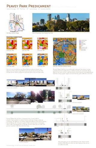
Land Use, 1984
Site Map, Ventura Village
Existing Conditions
View of Downtown from Peavey Field Park
Area Land Uses
Source: City of Minneapolis
Land Use, 1990 Land Use, 1997
Land Use, 2000 Land Use, 2005 Land Use, 2010
Portland+Franklin Looking North
Park+Franklin Looking South
Park+Franklin Park+Franklin Looking North
Columbus+Franklin Columbus+Franklin Looking North
10th+Franklin
11th+Franklin
11th+Franklin Looking North
Land Use, 2010 with satellite overlay
Over the years, the land use near Peavey Park has evolved to feature two
disparate activity nodes several blocks to the east and west of the park. This
Chicago Avenue divide is still present and noticeable in the streetscape today.
Ventura Village’s land use is overwhelmingly residential, but without a strong
central commercial corridor, there is nothing to anchor the community. Peavey
Park, if it saw more activity, could function as a shared amenity and neighborhood
hub, but a strong negative stigma associated with the park is difficult to overcome.
Ventura Village does not have a continuous sense of street width or
setbacks. This contributes to a lack of identity and sense of place within the
community. The difference in roadway design also influences this clash of identity.
East of Chicago Ave., the street consists of three narrower lanes, encouraging
slower traffic and parking. West of Chicago, the four traffic lanes are wider and
promote smoother traffic flow with fewer stops.
The streetscapes are one visual indication of the divide created
by Peavey Park. However, there are other indicators that are not
as readily noticeable.
.25mi .25mi .25mi
.25mi
.25mi
.25mi.25mi
2. Peavey Park Predicament A Land Use Rift in Ventura Village
Daniel Herriges Tian Qiu Jared Staley Zachary Zweifler
Fernando Burga | PA 5211 Land Use Planning | October 2015
Ventura Village’s low-income demographics
and proximity to downtown Minneapolis
contribute to a high rate of public transit use
along several different bus lines. Franklin
Avenue also carries heavy traffic through
Ventura Village, particularly west of Chicago
moving to and from freeway accesses. Two wide
one way avenues, Park and Portland,
also carry heavy through traffic and contribute
to a lack of consistent pedestrian orientation in
the streetscape. Yet, the majority of the
residents of Ventura Village are dependent on
transit and walking and have one of the city’s
lowest rates of personal vehicle ownership.
1459
2
Percent Public Transit Commuters
Legend
Ventura Village Neighborhood Boundary
Percent Public Transit Commuters
Legend
Ventura Village Neighborhood Boundary
Percent of Commuters Using Public Transit
0%-2%
2% - 5%
5% - 10%
10% - 15%
15% - 29%
Percent Public Transit Commuters
Legend
Ventura Village Neighborhood Boundary
Percent of Commuters Using Public Transit
0%-2%
2% - 5%
5% - 10%
10% - 15%
15% - 29%
Median Household Income
Legend
Ventura Village Neighborhood Boundary
Median Annual Income Per Household
$8,674 - $15,000
$15,001 - $30,000
$30,001 - $50,000
$50,001 - $75,000
$75,001 - $100,000
$100,001 - $176,838
Median Household Income
Legend
Ventura Village Neighborhood Boundary
Median Annual Income Per Household
$8,674 - $15,000
$15,001 - $30,000
$30,001 - $50,000
$50,001 - $75,000
$75,001 - $100,000
$100,001 - $176,838
Median Household Income
Legend
Ventura Village Neighborhood Boundary
Median Annual Income Per Household
$8,674 - $15,000
$15,001 - $30,000
$30,001 - $50,000
$50,001 - $75,000
$75,001 - $100,000
$100,001 - $176,838
Percent of Households with No Vehicle
Legend
Ventura Village Neighborhood Boundary
Percent of Households with No Vehicle
0% - 5%
5.01% - 15%
15.01% - 25%
25.01% - 40%
40.01% - 55%
55.01% - 100%
Percent of Households with No Vehicle
Legend
Ventura Village Neighborhood Boundary
Percent of Households with No Vehicle
0% - 5%
5.01% - 15%
15.01% - 25%
25.01% - 40%
40.01% - 55%
55.01% - 100%
Percent of Households with No Vehicle
Legend
Ventura Village Neighborhood Boundary
Percent of Households with No Vehicle
0% - 5%
5.01% - 15%
15.01% - 25%
25.01% - 40%
40.01% - 55%
55.01% - 100%
Percent White, Non-Hispanic
Source: ACS, 2014
Median Annual Income per Household
Source: ACS, 2014
Percent of Households with no Vehicle
Source: ACS, 2014
Average Transit Trips per Day
Transit Routes through Ventura Village
Average Automobile Traffic Volume
Percent of Commuters Using Public Transit
Source: ACS, 2014
Source: City of MinneapolisPublic Transit at Chicago Ave + Franklin Ave Intersection
Demographics + Transit
6200
4100
8300
9100
11000
12700
17100
11500 13500
Percent White, Non-Hispanic Population
Legend
Ventura Village Neighborhood Boundary
Percent White, Non-Hispanic Population
2.50 - 25.00
25.01 - 50.00
50.01 - 70.00
70.01 - 90.00
90.01 - 93.67
Percent White, Non-Hispanic Population
Legend
Ventura Village Neighborhood Boundary
Percent White, Non-Hispanic Population
2.50 - 25.00
25.01 - 50.00
50.01 - 70.00
70.01 - 90.00
90.01 - 93.67
Percent White, Non-Hispanic Population
Legend
Ventura Village Neighborhood Boundary
Percent White, Non-Hispanic Population
2.50 - 25.00
25.01 - 50.00
50.01 - 70.00
70.01 - 90.00
90.01 - 93.67
These maps and diagrams help illustrate an important point about the overall use of
Ventura Village. The great need for and use of public transit through the neighborhood
is an added stressor. Rather than bringing people to the area, the transit use and need for
public transportation creates a lack of ownership in the area. In order to better understand
this issue, it is important to better understand how the resident’s of the community interact
with each other, where they congregate, and how that can impact a place. Exploring these
issues further and reacting to them could help create a sense of place in Ventura Village.
3. Peavey Park Predicament A Land Use Rift in Ventura Village
Daniel Herriges Tian Qiu Jared Staley Zachary Zweifler
Fernando Burga | PA 5211 Land Use Planning | October 2015
Though private-sector disinvestment has caused
decline in the neighborhood, there are active
nonprofit institutions working in Ventura Village
to serve residents’ needs and help build a
stronger sense of place. Hope Community and
Project for Pride in Living (PPL) are two
prominent presences whose efforts and
investments have helped rehabilitate the area.
These nonprofits, despite divergent approaches
and priorities, have contributed greatly to the
revitalization of certain intersections. However,
this may not be enough to salvage and push the
community forward at a rate comparable to the
rest of the city. Key spatial characteristics of the
community are mapped below
Areas redeveloped and occupied by Hope
(Franklin & Portland), PPL (Franklin & 11th),
or where stores are located constitute key nodes
of informal congregation and conversation
within the neighborhood. A map of building
ages shows recent redevelopment concentrated
at sites several blocks west, east, and south of
Peavey Park. According to anecdotes from
community stakeholders, a stigma of violent
crime in Peavey Park continues to prevent
a mutually beneficial relationship between the
ample green space and adjacent residents and
business owners.
PortlandAve.
Franklin Ave.
HiawathaAve.
I-94
I-35W
ChicagoAve.
Year of Building Construction
Legend
Parks
Ventura Village Neighborhood Boundary
Year Built (Primary Structure)
n/a
1883 - 1949
1950 - 1999
2000 - 2010
2011 - 2015
PortlandAve.
Franklin Ave.
HiawathaAve.
I-94
I-35W
ChicagoAve.
Year of Building Construction
Legend
Parks
Ventura Village Neighborhood Boundary
Year Built (Primary Structure)
n/a
1883 - 1949
1950 - 1999
2000 - 2010
2011 - 2015
PortlandAve.
Franklin Ave.
HiawathaAve.
I-94
I-35W
ChicagoAve.
Vacant Parcels
Legend
Parks
Ventura Village Neighborhood Boundary
Occupied Parcels
Vacant Parcels
PortlandAve.
Franklin Ave.
HiawathaAve.
I-94
I-35W
ChicagoAve.
Vacant Parcels
Legend
Parks
Ventura Village Neighborhood Boundary
Occupied Parcels
Vacant Parcels
Median Single-Family Home Value
Legend
Ventura Village Neighborhood Boundary
Median Single-Family Home Value
$0 - $100,000
$100,001 - $200,000
$200,001 - $300,000
$300,001 - $400,000
$400,001 - $831,700
Median Single-Family Home Value
Legend
Ventura Village Neighborhood Boundary
Median Single-Family Home Value
$0 - $100,000
$100,001 - $200,000
$200,001 - $300,000
$300,001 - $400,000
$400,001 - $831,700
Median Single-Family Home Value
Legend
Ventura Village Neighborhood Boundary
Median Single-Family Home Value
$0 - $100,000
$100,001 - $200,000
$200,001 - $300,000
$300,001 - $400,000
$400,001 - $831,700
Mosaic Seating at Peavey Park Source: City of Minneapolis
Median Single-Family Home Value
Source: ACS, 2014
Building Age
Source: ACS, 2014
Parcel Occupancy
Source: ACS, 2014
Neighborhoods near Peavey Park Major Community Resources Informal Nodes of Congregation
Transit Stop LocationsOff-Street Surface Lots
Community Influences
What steps are needed to
see the community grow and
develop to meet community
demands?
How can we maximize area
stakeholders’ strengths to
better serve the Ventura Village
neighborhood and Peavey Park?
RESOURCE-MN
Service organization
providing career
education, employment,
chemical and mental
health services.
AAA DAILY LABOR
HOPE COMMUNITY, INC.
Nonprofit focused on affordable housing
development, community organizing
and capacity building. Has redeveloped
all four corners of Franklin / Portland
intersection with mixed-income housing.
CHICAGO CROSSING
Commercial strip mall.
Restaurants and
ethnic-oriented
convenience stores.
HOPE ACADEMY
Christian private school serving grades K-12.
LEARNING CENTER
PPL (PROJECT FOR
PRIDE IN LIVING)
Adult education, job
and skills training.
CENTRO CULTURAL
CHICANO
Adult literacy, youth
education, health and
wellness programs.
SOCIAL SECURITY
ADMINISTRATION
NORWEGIAN LUTHERAN
MEMORIAL CHURCH
RED AND WHITE TAXI
Taxi company, legacy auto-
oriented land use long
established on Franklin Avenue.
PROJECT FOR PRIDE IN LIVING
(PPL) Nonprofit organization
dedicated to integrated social
services and affordable housing.
4. Peavey Park Predicament A Land Use Rift in Ventura Village
Daniel Herriges Tian Qiu Jared Staley Zachary Zweifler
Fernando Burga | PA 5211 Land Use Planning | October 2015
It is important for the overall image of the
community and Minneapolis that
Ventura Village develop in a way that
complements its residents’ needs. Peavey Park
is a historical cornerstone to the community,
but over the years has become a spatial divide.
With the help of strong community input, the
city, and devoted private developers, Peavey
Park and Ventura Village can be born
again from the ashes.
While many entities may have unique takes on
how to propel this process forward, it would be
best to have a collaborative and majority
consensus.
Problem
The Effort to Revitalize Peavey Park
Peavey Park Pride
Athletes Playing Soccer at Peavey Park Source: Daniel Herriges
“in the shadow of
the Vikings stadium,
practically” - Hope
Communities
“Peavey Park: Central to
the Wellness Corridor
Brand” - Chicago Avenue
Corridor Plan
“While Peavey Park sits in a
centrally located geographic
position within the city, the altered
urban fabric around it has isolated
the park and neighborhood from
the surrounding neighborhoods
and landmarks” - Metropolitan
Design Center
• “Community Listening” process led by
Hope Community
• 2010 formation of Community Advisory
Board including the Minneapolis Park
Board, Police Department, community
leaders, business owners, and residents
• Requested support from U of M’s Metro-
politan Design Center
• MDC publishes proposal for complete
redesign of Peavey Park in 2011
• South Quarter project: redeveloped all four
corners of Franklin & Portland intersection
with affordable housing and neighborhood-
owned businesses
• Final corner in South Quarter completed
in 2015 with The Rose mixed-income
apartments
“Branding Chicago Avenue as the Wellness Corridor
serves two important purposes. First, it provides a
self-determined identity that will begin to influence
the way outsiders think about the area. Second, it
serves as a succinct and meaningful slogan around
which the many stakeholders in the area can organize
their efforts. It reflects the way the community sees
its existing assets and future vision, and continues
to showcase the concentration of medical-related
institutions in the area.”
• “PPL works with lower-income individuals
and families to achieve greater self-sufficiency
through housing, employment training,
support services, and education.”
• Headquartered in Phillips, provides services
and affordable housing development to metro
area
There has long been no shortage of vision for Peavey
Park, and yet it and the adjacent intersection have
languished as a site of crime and disinvestment.
“The issues at Peavey
Park aren’t really about
land use. The question is
what would it take for the
neighborhood to feel that
area was safe?”
- Barbara McCormick,
Senior Vice President, PPL
+ =Land Use Development
Eyes on the
Street