Recommended

Recommended
More Related Content
What's hot
What's hot (15)
Similar to Use ESRI's Crowd Source Apps to Collect Geospatial Public Comments
Similar to Use ESRI's Crowd Source Apps to Collect Geospatial Public Comments (20)
Use ESRI's Crowd Source Apps to Collect Geospatial Public Comments
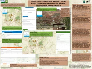
- 1. Layers Use the agencies hosted layers on AGOL, or host your own unique feature layer by sharing the layer as a hosted service in ArcGIS for Desktop, to create your project’s map. Talking Points Collaborative Mapping (TPCM): ESRI’s Crowd Source Reporter and Manager Configured for Use by the USFS What is Participatory GIS? Participatory GIS is an emerging field that utilizes GIS technologies to involve the public. The traditional scoping method of mailed comments didn’t give specific geographic locations nor did it allow for a dialogue among the public. Participatory GIS on the other hand allows comments to be tied to specific locations and, if desired, allows the public to respond to each other. What need does it fill? The Forest Service Planning Rule mandates public involvement in national forest planning and encourage the pro-active use of contemporary tools such as the Internet to engage the public (36 CFR 219.4). Public involvement shall occur in assessment, proposal, and monitoring stages and tools which are interchangeably useful in all stages and all types of stakeholders and individuals are especially useful. The TPCM website meets this need and provides similar opportunities for use (1) entirely within a national forest for intra-staff communications and (2) to collect compare and study similarities and differences in public comments across all participating national forests. Manager Application Project managers can view all comments in real time while the comment period is still open using ESRI’s Crowdsource Manager application. These comments can be hidden or revealed as desired, replied to by managers, removed from public view, and much more! TPCM Overview Talking Points Collaborative Mapping was created in accordance with the Forest Service Planning Rule that mandates public involvement in National Forest Planning and encourages the pro-active use of contemporary tools to engage the public (36 CFR 219.4). TPCM helps the USFS meet the Open Gov Initiative, "creating an unprecedented level of openness in Government." TPCM is a configuration of ESRI's ArcGIS online Crowdsource Reporter/Manager applications branded specifically for USFS use. Using ESRI's configurable applications saves the USFS and taxpayers’ money by eliminating operation and maintenance costs. ESRI takes care of code updates, development, and security protocols and works with the USFS to perfect the applications. TPCM helps to meet the USFS community participation and public scoping needs by receive public comments and threads on an online map. TPCM can be used for any public scoping need including Forest Plan Revision, Developed Recreation, Forest Restoration, Wilderness, National Scenic Trails, and other projects that require public input. This online application can even be tailored for inter-staff communication and collaboration! Forests can track and manage public comments; databases are automatically generated, and can be easily exported as File Geodatabase, CSV, or shapefiles. Individually and collectively, data mined from these public scoping efforts can provide rich sources for public reporting, as well Forest- wide, regional, or national meta-analyses. ESRI’s Configurable Crowdsourcing Applications Crowd Source Reporter and Manager are ESRI’s ArcGIS Online (AGOL) configurable applications that have been rebranded and configured by the USFS as Talking Points Collaborative Mapping (TPCM). These applications allow managers to collect geospatial comments from the public. Disclaimer of Liability: With respect to this document, neither the United States Government nor any of its employees, makes any warranty, express or implied, including the warranties of merchantability and fitness for a particular purpose, or assumes any legal liability or responsibility for the accuracy, completeness, or usefulness of any information, apparatus, product, or process disclosed, or represents that its use would not infringe upon privately owned rights. TPCM owes thanks to all our partners at Esri, USDA Forest Service Teams: Ecosystem Management Coordination (EMC) – Human Dimensions Program, FS Chief Information Office (CIO), FS Enterprise Data Warehouse (EDW), FS Geospatial Management Office (GMO), Regions 3 & 4 GIS & Planning Subject Matter Experts and FS Enterprise Program WebGIS Team.ESRI Federal GIS Conference, Washington, DC February 13-14, 2017 Creating a New Project Easy as 1… 2… 3… 1) Create a Map Comment Feature Layer Copy the preconfigured TPCM empty comment feature layer from the USFS organization to your project folder on AGOL and add it to your map. This will be used by the application to collect and export comments. Comments can be exported as a shapefile, CSV (Excel), or a file geodatabase for analysis. Branding Crowd Source Reporter allows us to configure applications using our own branding and images. Each project has a unique splash page (pictured below) and the configuration of each app is very simple. Source: http://www.esri.com/software/configurable-apps Reporter Comments Once the application is published comments can be left with points, lines, or polygons (each project can be configured to use one or a combination of all geometry types). The commenter can sign in without an account and can easily comment. The commenter can choose to leave a name or contact information, though this is completely optional. Others can then reply to the comment, creating a conversation. 1) Create a Map 2) Configure the Application 3) Publish Advantages of Using TPCM TPCM has numerous advantages over traditional scoping techniques such as: • Increased spatial referencing of public comments, especially with regard to other available national forest data layers • True collaborative capabilities allowing public commenters to communicate with each other as well as with Forest Service staff in “real time” discussion as opposed to collection (with contact information optional and confidential) • Easy integration of photos and URL links to other documents • Automatic documentation of comments and spatial locations • Potential for NFS wide comparisons of public comment themes and trends • ArcGIS Online platform is compatible with standard Forest Service GIS format • Easy and very low cost to implement with available help desks • Saves the agency and tax payers’ money