(NANDITA) Hadapsar Call Girls Just Call 7001035870 [ Cash on Delivery ] Pune ...
Properties_of_Ocean_Water_2017_A-F.pptx
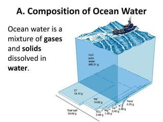
1. A. Composition of Ocean Water
Ocean water is a
mixture of gases
and solids
dissolved in
water.
2. 1. Gases: CO2 and O2, and Hydrogen
2. Solids: 3.5 % dissolved
minerals like:
Ca, Na, Fe, and Si.
3. Disassociate into ions:
+ Na, Ca, K, Mg
- Cl, SO4, CO3, OH
3. B. Salinity: The amount of dissolved salts in
water. Measured in parts per thousand (ppt or
o/oo) (#g/1,000g = #g/L).
1. NaCl is the major salt in the world ocean.
2. MgCl is the second most abundant salt in the
ocean.
3. The average salinity of the ocean is 35 parts per
thousand (ppt) .
Salinty ranges from 33 to 38 ppt
depending on evaporation and
fresh water input.
4.
5.
6. Source of Salts: Where did the Oceans get their salt?
a/ Volcanism in
the Oceans
release
H2O, HCl (acid)
and CO2
Original oceans
were acidic!
7. b/ Chemical Weathering of rocks release
minerals Ca, Na, K, Mg
Rivers are alkaline (base).
8. c/ Billions of years ago…. Rivers (base) reacted
with oceans (acid) in a neutralization reaction to
form salt and water!
d/ Salinity is currently constant!
10. A/ Lower salinity occurs where more fresh water
enters the oceans.
1/ Precipitation
2/ River runoff
3/ Melting of ice
4/ Groundwater flow to oceans
11. B/ Higher salinity occurs
where fresh water is
removed and less fresh
water enters the
oceans.
1/ Hot oceans where there
is little precipitation or
runoff and a lot of
evaporation.
2/ Freezing of seawater
leaves behind salt.
Seasonal.
12. 6. Salinity Profile (Variations with depth)
a/ Salinity increases
with depth.
13. a) Surface Zone: Less salt
b) Halocline: The vertical
zone in the ocean
column where salinity
increases rapidly with
depth.
c) Deep Zone: Greater
salinity.
15. 7. Sea Surface Salinity
Use diagram to describe variation in surface Salinity
across Earth’s Oceans. Use Latitudes to help.
Equatorial ~0oLat.?
22oN and S Lat.?
Polar 60-90o N/S?
Mediterranean Sea?
16.
17. 7. Sea Surface Salinity
Equatorial ~0oLat.? High 35.5-36
22oN and S Lat.? Highest 36.5-37.5
Polar 60-90o N/S? Lowest 32-34
Mediterranean Sea? Highest 37.5-38.5
18.
19. C. Temperature
1/ Ocean temperature
varies with the
amount of solar
radiation received.
The amount of solar
radiation received
depends on latitude,
and depth.
20. 2/ The temperature of the
surface layer varies
from 36oF … 97oF and
-2oC … 28oC.
3/ Sea water with an
average 35ppt salinity
freezes at -2oC (28.5oF).
4/ Average Temperature of
surface waters is 17oC (63oF).
21. 5/ Surface waters are warmer at the equator and
colder at the poles.
6/ Ocean waters are warmer near the surface and
colder with depth.
22. 7. Temperature Layers
Mixed Layer: (surface) Solar
radiation and mixing makes
uniform temperature. Warmer.
Thermocline: Temperatures
decreases rapidly. Acts as a
barrier. 300-1000m deep.
Deep water: Very cold uniform
temperature.
23. 8. The Thermocline
a/ Changes with latitude:
1/ Deepest at the Equator.
2/ Shallowest or non-existant at higher latitudes.
24.
25. The Deep Layer is very cold!
1/ 90% of all Ocean water lies beneath the
thermocline.
2/ The deep ocean layer is not mixed well and
consists of density layers.
3/ The deep layer is very cold all around the
world 0-3oC (32-37.5oF).
26. Argos
A system of hundreds of buoys at the surface
descend deep and rise over time sending data
to satellite giving us real time data on salinity
and temperature in the layers of the sea.
29. E. DENSITY of Ocean Water
1. Density = mass /volume How heavy for size.
2. Density of pure water is 1.0 g/cm3
3. The average density of ocean water is 1.027
g/cm3 It ranges from 1.02 to 1.03.
4. Denser ocean water sinks!
5. Ocean water density depends on:
salinity, temperature & pressure
30. 6/ Density of water is
mostly determined by
temperature.
7/ Cold water sinks.
Warm water rises.
8/ Density is also effected
by salinity. Salty water
is heavier … Sink!
Less saline water is
lighter ... rises.
31. 9/ Density Profiles
a/ Density increases with
depth.
b/ Warmer, less salty water at
surface and colder, saltier
water in the Deep.
c/ The region of rapid density
change is called the
pycnocline. It acts as a
barrier between Deep and
surface waters. 300-1000m
deep.
32. 10/ Density in Polar Waters (High Latitudes)
a/ Cold, salty waters in the polar regions have
little to no pycnocline. They start out dense
and stay dense all the way down to the
bottom.
33. b/ These waters sink to the deep zone driving
deep sea circulation! They bring oxygen
nutrients down with them.
https://www.youtube.com/watch?v=FuOX23yXhZ8