Beginners Guide to TikTok for Search - Rachel Pearson - We are Tilt __ Bright...
our country india (VI).pdf
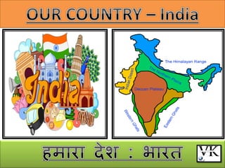
1.
2. India is a country of vast
geographical expanse.
बायत एक फहुत फड़े बौगोलरक
विस्ताय िारा देश है।
In the NORTH, it is bound by the
LOFTY HIMALAYAS.
उत्तय भें मह हहभारम क
े ऊ
ॉ चे
लशखयों से घघया है।
The ARABIAN SEA in the WEST
ऩश्चचभ भें अयफ सागय
the BAY OF BENGAL in the EAST
ऩूिव भें फॊगार की खाड़ी
The INDIAN OCEAN in the SOUTH
दक्षऺण भें हहॊद भहासागय
3. The peninsula is a piece of land that is
surrounded by water on three sides
प्रामद्वीऩ, स्थर का वह बाग है जो तीन तयप
से जर से घघया होता है
4. India has an area of about 3.28 million sq. km.
बायत का ऺेत्रपर 32.8 राख वगग ककभी. है।
The north-south extent from Kashmir to Kanyakumari is about 3,200
km. उत्तय भें कश्भीय से रेकय दक्षऺण भें कन्माक
ु भायी तक इसका
ववस्ताय रगबग 3,200 ककभी. है
The east-west extent from Arunachal Pradesh to Kutch is about
2,900 km.
ऩूवग भें अरुणाचर प्रदेश से रेकय ऩश्श्चभ भें कच्छ तक इसका ववस्ताय
रगबग 2,900 ककभी. तक है।
It is the second most populous country of the world after China.
मह चीन क
े फाद ववश्व का दूसया सफसे अधधक जनसॊख्मा वारा देश
है।
India has a population of more than one hundred twenty crores
since the year 2011. िर्व 2011 से अफ तक बायत की आफादी 120
कयोड़ से अधधक हो चुकी है।
7. Locational Setting श्स्थघत
India is located in the northern hemisphere.
बायत उत्तयी गोराधव भें श्स्थत है।
The Tropic of Cancer (23°30’N) passes almost halfway through the
country
कक
ग येखा (23°30'उ.) देश क
े रगबग भध्म बाग से होकय गुजयती है
From south to north, main land of India extends between 8°4’N and
37°6’N latitudes.
दक्षऺण से उत्तय की ओय बायत की भुख्म बूलभ का विस्ताय 8°4' उ.
तथा 37°6' उ. अऺाॊशों क
े फीच है।
From west to east, India extends between 68°7’E and 97°25’E
longitudes.
ऩश्चचभ से रेकय ऩूिव तक बायत का विस्ताय 68°7' ऩू. तथा 97°25'
ऩू. देशाॊतयों क
े फीच है।
India lies in eastern hemisphere बायत ऩूिी गोराधव भें श्स्थत है।
8. Due to great longitudinal extent of about 29°, there could be a wide
differences in local time of places located at two extreme points of India. As
such, the difference between these two points would be of about two
hours.
फहुत फड़े देशाॊतयीम विस्ताय रगबग 29° क
े कायण महाॉ क
े दो छोय ऩय
श्स्थत स्थानों क
े स्थानीम सभम भें फहुत अधधक अॊतय हो सकता था। इस
तयह की दूयी ऩय श्स्थत दो स्थानों क
े फीच सभम का अॊतय रगबग दो घॊटे
का होगा।
The local time changes by four minutes for every one degree of longitude.
प्रत्मेक 1° देशाॊतय क
े लरए स्थानीम सभम भें 4 लभनट का अॊतय होता है।
The sun rises about two hours earlier in the east (Arunachal Pradesh) than
in the west (Gujarat). ऩश्चचभ भें गुजयात की अऩेऺा ऩूिव क
े अरुणाचर प्रदेश
भें सूमोदम रगबग दो घॊटे ऩहरे होता है।
82°30’E has been taken as the Indian Standard Time. This meridian or
longitude is also termed as the Standard Meridian of India.
82°30' ऩू. देशाॊतय क
े स्थानीम सभम को बायत का भानक सभम भाना गमा
है। इस माम्मोत्तय को बायत का भानक माम्मोत्तय बी कहा जाता है।
9. india’s neighbours बायत क
े ऩड़ोसी देश
Land neighbours:-
1. Pakistan
2. Afghanistan
3. China
4. Nepal
5. Bangladesh
6. Bhutan
7. Myanmar
Landlocked neighbours:-
1. Nepal
2. Bhutan
Island neighbours:-
1. Sri lanka
2. Maldives
Sri Lanka is separated from India by the Palk Strait.
ऩाक जरसॊधध बायत को श्रीरॊका से अरग कयती है।
10.
11. POLITICAL AND ADMINISTRATIVE DIVISIONS
याजनीघतक एवॊ प्रशासघनक ववबाजन
The country is divided into 28 States and 8 Union
Territories.
देश को 28 याज्मों एवॊ 8 क
ें द्रशाससत प्रदेशों भें फाॉटा गमा है।
1. Ladakh
2. Jammu & Kashmir
3. Puducherry
4. Lakshadweep
5. Delhi
6. Chandigarh
7. Dadra and Nagar Haveli and Daman & Diu
8. Andaman and Nicobar Islands
12. Delhi is the national capital.
हदल्री बायत की याजधानी है।
The states have been formed mainly on the basis of
languages.
याज्मों का घनभावण भुख्मत् बार्ाओॊ क
े आधाय ऩय हुआ है।
Largest state :- Rajasthan
ऺेत्रपर की दृश्टट से सफसे फड़ा याज्म याजस्थान
Smallest state :- Goa
सफसे छोटा याज्म गोिा है।
CENTRE STATE DISTRICT
13. Physical Divisions बौघतक
ववबाजन
Diversity of physical division
mountains, plateaus, plains, coasts and islands
ऩिवत, ऩठाय, भैदान, तट तथा द्िीऩसभूह।
1. Himalayas हहभारम
2. Northern Indian plains बायत का उत्तयी भैदान
3. Great Indian desert बायतीम भहाभरुस्थर
4. Peninsular plateau प्रामद्वीऩीम ऩठाय
5. Coastal plains तटीम भैदान
6. Islands द्वीऩसभूह
14.
15. Himalayas हहभारम
Him+alaya mean ‘the abode of snow’.
हहभ+आरम का भतरफ होता है फप
ग का घय।
The Himalayan mountains are divided into three
main parallel range
हहभारम ऩिवत को तीन भुख्म सभानाॊतय शॊखराओॊ भें
फाॉटा जाता है।
1. Great Himalaya or Himadri
2. Middle Himalaya or Himachal
3. Shiwalik
16.
17. The northernmost is the Great
Himalaya or Himadri
उत्तय भें श्स्थत शॊखरा को िहत
हहभारम मा हहभाहि कहते हैं।
Middle Himalaya or Himachal lies
to the south of Himadri.
भध्म हहभारम मा हहभाचर, हहभाहि
क
े दक्षऺण भें श्स्थत है।
The Shiwalik is the southernmost
range.
सशवासरक सफसे दक्षऺण भें श्स्थत
शॊखरा है।
18. The Northern Indian plains
बायत का उत्तयी भैदान
The Northern Indian plains lie to the south of the Himalayas. They
are generally level and flat
हहभारम क
े दक्षऺण भें बायत का उत्तयी भैदान श्स्थत हैं मे भैदान
सभतर तथा सऩाट हैं।
These are formed by the alluvial deposits laid down by the rivers–
the Indus, the Ganga, the Brahmaputra and their tributaries.
मे भैदान लसॊधु, गॊगा, ब्रह्भऩुत्र तथा इनकी सहामक नहदमों क
े द्िाया
राए गए जरोढ़ घनऺेऩों से फने हैं।
These river plains provide fertile land for cultivation.
नहदमों क
े मे भैदान कवर् क
े लरए उऩजाऊ बूलभ प्रदान कयते हैं।
That is the reason for high concentration of population in these
plains.
मही कायण है कक इन भैदानों भें जनसॊख्मा अधधक है।
19. Alluvial deposits : These are very fine soils, brought by rivers
and deposited in the river basins.
जरोढ़ घनऺेऩ : मे नहदमों क
े द्िाया राई गई फहुत भहीन
लभट्टी होती है तथा नदी फेलसन भें घनऺेवऩत कय दी जाती है।
Tributary : A river or stream which contributes its water to a
main river by discharging it into main river from either side
सहामक नदी्
एक नदी मा सरयता जो कक भुख्म नदी भें ककसी बी तयप से
आकय लभरती है तथा अऩने जर को भुख्म नदी भें विसश्जवत
कयती है
20. The Ganga and the Brahma-putra
form the world’s largest delta, the
Sundarbans delta. The delta is
triangular in shape. It is an area of
land formed at the mouth of the river
(Where rivers enter the sea, that
point is called the mouth of the river)
गॊगा एवॊ ब्रह्भऩुत्र नहदमाॉ ववश्व क
े
सफसे फड़े डेल्टा का घनभागण कयती हैं,
श्जसे सुन्दयफन डेल्टा कहा जाता है।
इस डेल्टा की आकघत त्रत्रबुजाकाय है।
डेल्टा स्थर का िह बाग है जो नदी
क
े भुहाने ऩय फनता है (जहाॉ नहदमाॉ
सभुद्र भें प्रवेश कयती हैं उस जगह को
नदी का भुहाना कहा जाता है)
21. The Great Indian desert
बायतीम भहाभरुस्थर
In the western part of India lies
the Great Indian desert.
बायत क
े ऩश्चचभी बाग भें
बायतीम भहाभरुस्थर श्स्थत है।
It is a dry, hot and sandy stretch
of land.
मह शुटक, गभव तथा येतीरा स्थर
है।
It has very little vegetation.
महाॉ िनस्ऩघत की भात्रा फहुत
कभ है।
22. Peninsular plateau प्रामद्वीऩीम ऩठाय
It is triangular in shape. The relief is highly uneven.
इसकी आकघत त्रत्रबुजाकाय है। इसका धयातर कापी ऊ
ॉ चा-नीचा
है
Peninsular plateau have numerous hill ranges and valleys.
प्रामद्िीऩीम ऩठाय भें फहुत-सी ऩहाड़ी शॊखराएॉ तथा घाहटमाॉ
श्स्थत हैं।
Aravali hills अयावरी शॊखरा
The Vindhyas ववॊध्म
Satpuras (Narmada and Tapi) सतऩुड़ा (नभगदा तथा ताऩी)
The Western Ghats or Sahyadris ऩश्श्चभी घाट मा
सह्माहद्र
Eastern Ghats ऩूवी घाट
23.
24.
25. Aravali hills, one of the oldest ranges of the world, border it on the north-
west side.
उत्तय-ऩश्चचभ भें अयािरी शॊखरा श्स्थत है, जो विचि की सफसे ऩुयानी शॊखरा है।
The Vindhyas and the Satpuras are the important ranges. The
rivers Narmada and Tapi flow through these ranges. These are west-flowing
rivers that drain into the Arabian Sea.
विॊध्म एिॊ सतऩुड़ा बी भहत्त्िऩूणव शॊखराएॉ हैं। इन शॊखराओॊ से होकय नभवदा
तथा ताऩी नहदमाॉ फहती हैं। मे ऩश्चचभ की तयप फहने िारी नहदमाॉ हैं, जो
अयफ सागय भें धगयती हैं।
The Western Ghats or Sahyadris border the plateau in the west and
the Eastern Ghats provide the eastern boundary. While the Western Ghats are
almost continuous, the Eastern Ghats are broken and uneven
इस ऩठाय क
े ऩश्चचभ भें ऩश्चचभी घाट मा सह्माहि तथा ऩूिव भें ऩूिी घाट श्स्थत
है। ऩश्चचभी घाट का विस्ताय एकसभान रूऩ भें है, जफकक ऩूिी घाट फीच-फीच भें
टूटा हुआ तथा असभान है
The plateau is rich in minerals like coal and iron-ore.
इन ऩठायों भें खघनजों; जैसे- कोमरा एिॊ रौह अमस्क की प्रचुयता है।
26. Coastal plains तटीम भैदान
To the West of the Western Ghats and the East of Eastern Ghats lie the Coastal
plains.
ऩश्चचभी घाट क
े ऩश्चचभ भें तथा ऩूिी घाट क
े ऩूिव भें तटीम भैदान श्स्थत हैं।
The western coastal plains are very narrow. The eastern Coastal plains are
much broader.
ऩश्चचभ तटीम भैदान कापी सॉकये हैं। ऩूिी तटीम भैदान अऩेऺाकत चौड़े हैं।
There are a number of east flowing rivers. The rivers Mahanadi, Godavari,
Krishna and Kaveri drain into the Bay of Bengal.
ऩूिव की ओय फहने िारी कई नहदमाॉ हैं। भहानदी, गोदाियी, कटणा तथा कािेयी
फॊगार की खाड़ी भें धगयती हैं।
These rivers have formed fertile deltas at their mouth. The Sunderban delta is
formed where the Ganga and Brahmaputra flow into the Bay of Bengal.
मे नहदमाॉ अऩने भुहाने ऩय उऩजाऊ डेल्टा का घनभावण कयती हैं। फॊगार की खाड़ी
भें गॊगा एिॊ ब्रह्भऩुत्र नहदमों क
े भुहाने ऩय सुॊदयफन डेल्टा श्स्थत है।
27.
28. islands द्वीऩसभूह
Two groups of islands also form part of India.
बायत भें दो द्वीऩसभूह बी हैं।
1
Lakshadweep Islands are located in the Arabian Sea.
रऺद्वीऩ द्वीऩसभूह अयफ सागय भें श्स्थत हैं।
These are coral islands located off the coast of Kerala.
मे क
े यर क
े तट से क
ु छ दूय श्स्थत प्रिार द्िीऩ हैं।
2
The Andaman and the Nicobar Islands lie to the southeast of the
Indian mainland in the Bay of Bengal.
अॊडभान एवॊ घनकोफाय द्वीऩसभूह बायत से दक्षऺण-ऩूिव हदशा भें फॊगार
की खाड़ी भें श्स्थत हैं।
29. Corals are skeletons of tiny marine animals called Polyps. When the
living polyps die, their skeletons are left. Other poplyps grow on top of
the hard skeleton which grows higher and higher, thus forming the coral
islands.
प्रिार छोटे सभुिी जॊतुओॊ क
े क
ॊ कार हैं श्जसे ऩॉलरऩ कहा जाता है। जफ
जीवित ऩॉलरऩ भयते हैं तफ उनका क
ॊ कार फच जाता है। अन्म ऩॉलरऩ की
िद्धध इन ठोस क
ॊ कारों क
े ऊऩय होती है, जो फढ़ते-फढ़ते कापी ऊ
ॉ चे होते
जाते हैं तथा इस प्रकाय प्रिार द्िीऩों का घनभावण कयते हैं।
30. Do you know which group of islands were affected by the Tsunami in
2004?
The Andaman and the Nicobar Islands
Tsunami is a huge sea wave generated due to an earthquake on the sea
floor.
सुनाभी एक विशार सागयीम तयॊग है जो सभुि तर ऩय बूक
ॊ ऩ क
े कायण
उत्ऩन्न होती है।