ECDM_20211022_India-Nepal.pdf
- 1. I N D I A
LANDSLIDE HAZARD
Very low
Low
Medium
High
Source: World Bank
Emergency Response Coordination Centre (ERCC) – DG ECHO Daily Map | 22/10/2021
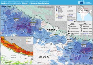
India (Uttarakhand), Nepal | Recent landslides
N E P A L
C H I N A
I N D I A
N E P A L
C H I N A
22
6
21
64
© European Union, 2021. Map produced by the JRC. The
boundaries and the names shown on this map do not imply
official endorsement or acceptance by the European Union.
28 Injured people
IMPACT OVERVIEW
As of 16 October
49 Fatalities
36 Missing people
NEPAL
Sudurpaschim, Province 1, Karnali
INDIA
Uttarakhand
64 Fatalities
2 Missing people
22 Injured people
1,385 Evacuated
people
Source: NDM India, DRR Portal as
reported on 21 Oct
* State in India, Province in Nepal
Additional daily maps on landslides
in India and Nepal are available on
the ERCC Daily Map portal.
Snow coverage
as of 21 Oct
District affected by
landslides
PAST 7-DAY
RAINFALL ACCUMULATION
Source: NASA-GPM
100-250 mm
250-500 mm
50-100 mm
Name Affected state (India),
province (Nepal)
Source: NDM India , DRR
Disputed area
Disputed country border
Source: USNIC
Main road
River
Water body
Administrative border*
District border
Urban centres
Country border
Source: JRC GHSL-UCBD
Main airport
The pictorial representation does not
purport to be the political map of India.