1. Goshen
Gibbon
Marrtown
Centreville
Summerfield
Carsonville
Pearsonville
Mount
Hebron
Pleasant
Ridge
Thompson
Corner
Snider
Mountain
Jordon Mountain
Mount
Middleton
Kierstead
Mountain
Head of
Millstream
M
illB
rook
BeattyBrook
Ryans
Brook
Harry Brook
S
n
yder Brook
Hawkes
Brook
K
enne
b
ecBro
ok
HarrisonBrook
Cameron B
rook
Morr
is
on
Broo
k
ChapmanBrook
HarryBrook
Long
Creek
Sny
derBrook
M
illstream
River
M
illstrea m River
M
cNairBrook
PascobacBrook
MillBrook
B
eatty B
rook
Chap
man Brook
Mill Brook
Leonard Road
RitchieRoad
Brunnell Road
ChittickRoad
Mount Hebron Road
MountainR
oad
Steen Road
Frazee Road
OgdenRoad
GibbonMountainRoad
Hayes Road
BarrettRoad
Guilfoyle Road
MineRoad
IrishSettlementRoad
TaitRoad
RobinsonRoad
Harry Brook Road
Gailey
Road
Taylor Road
Morgan Hill Road
DagninoRoad
Knightville Road
Horn
brook Road
Mount Hebron Cross Road
Kie
r
stead M ountain Loop Rd.
Pleasant Ridge Branch Road
SniderM
ountain
Road
ShortcutRoad
Pleasa
ntR
idgeRoad
CarsonvilleRoad
DyerRoad
Route
10
Carsonville Road
McM
illan
Road
Keith Road
Creek Road
Mount Middleton
Road
DingleyRoad
Barret
tRoad
Schofield Road
Windgap Road
SmithRoad
JordanRoad
DagninoRoad
JordanRoad
BackRoad
Old Route No. 9
Old No. 9 Bye
GamblinRoad
Watson Road
ThompsonRoad
Route10
OldPearsonvilleRd.
Carsonville
Ro ad
Carso
nville
R
oad
MountHebronRoad
Route880
Route880
Di
ngleyRoa
d
SniderMountain
Road
PearsonvilleRoad
Route87
0
PleasantRi
dge
Road
Goshen
R
oad
Carsonville Road
S
tu
d
h
o
lm
P
a
rish
S
tu
d
h
o
lm
P
a
rish
S p r i n g f i e l d
P a r i s h
S p r i n g f i e l d
P a r i s h
S t u d h o l m
P a r i s h
S t u d h o l m
P a r i s h
J
o
h
n
sto
n
P
a
rish
J
o
h
n
sto
n
P
a
rish
63
28
35
69
32
31
33
26
23
37
30
29
36
27
34
41
40
135
39
40
38
74
25
61
73
42
103
24
43
51
60
50
64
67
78
56
58
44
53
52
68
55
65
81
83
59
77
76
72
57
70
38a
48
83a
84
84
71
174
47
62
167
145
66
140
206
156
205
211
49
80
203200
297
296
177
148
202
149
173
207
210
196
101
172
194
170
209
195
213
189
244
193
212
171
201
199
176
192
141
190
245
198
134
150
152
137
191a
138
214
191
189a
102
204
138
208
169
133
197
199a
215
178
142
136
304
35a
163 179
22
143
144
162
166
298
216
164 165
54
45
46
175
159
155
153
75
157
154
158
168
135a
82
86
166b
175b
139
151
166a
161
146
180
160
7979 246
99
217
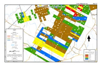
Centre Millstream Area Map A-2
Ethnic Origins of Settlers who received Land Grants Map
Legend
1:50,000
0 1 20.5
Km
Collector
On/Off Ramp
Arterial Railroad
Highway
Municipal
Local
Road Network
Parish Limits
Boundaries
Land Settlement
Land Grant200
Hydro Features
Waterbody
Rivers
These Maps were computer-generated by Gerald Legacy and
are based upon three separate land grant maps- Maps#129, 130
and 140 which are available for Viewing at the Land Registry
Office, Service New Brunswick, Hampton NB.
Sources:
Ethnic Origins of Settlers
SOURCES
See Ethnicity Index Map
Legend
Ethnic Origins of Settlers Map
English
French
German
Larger Freeholders
Irish
Scottish