1. Scale 1:10000
0 0.25 0.5 0.75 1km
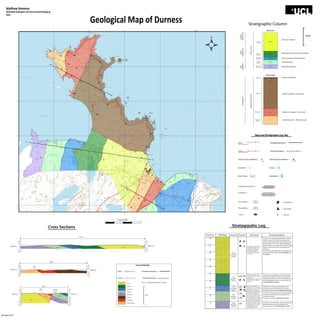
Geological Map of Durness
Matthew Simmons
GEOL2026 Geological and Environmental Mapping
2014
40
67
69
68
70
71
38 39 41
38 39 40 41 42
67
68
69
70
971000m
242000m
Stratigraphic Column
A
A
B
22
25
12
14
14
16
14
15
17
20
28
33
40 35
23
31
29
21
32
29
23
21
17
22
18
27
25
27
19
23
31
26
28
32
29
39
30
36
41
39
31
34
30
49
48
19
21
31
14
21
18
14
14
15
14
12
10
14
25
C
C
LST_1
LST_2
LST_3 LST_4
LST_5
LST_2
LST_3
η_2
η_3
η_3
η_2
η_1
η_1
B
η_4
DurnessGroup
MIDDLE
ORDOVICIAN
EARLY
ORDOVICIAN
LATE
CAMBRIAN
Quartz-rich Mylonite
Psammitic Mylonite - Thrust sheet
Mylonitic Orthogneiss - Thrust sheet
Garnet Mica Schist - Thrust zone rocksOystershell
Rock
Orthogneiss
Psammite
MoineThrustMylonites
Balnakeil
Formation
Durine
Formation
Sangomore
Formation
Sailmohr
Formation
Eilean Dubh
Formation
LST_5
LST_4
LST_3
LST_2
LST_5
Dolomitic Limestone
Microbialitic Limestone with Stromatolites
Cherty Limestone with Stromatolites
Cherty Dolostone
Microbialtic Dolostone
Sedimentary
Metamorphics
LST_5
LST_4
LST_3
LST_2
LST_5
Sedimentary
Metamorphics
η_3
η_3
η_1
η_2
Mylonite
PROTEROZOIC
Map and Stratigraphic Log Key
Fault = Geological Boundary =
Thrust = Inferred Boundary =
Strike and Dip of Bedding = Strike and Dip of Foliation =
Grassland = Dunes =
Beach Sand = Marshland =
(Tick on downthrow side)
(Barbs on hanging well)
15 41
500m
Dolimitised Limestone =
Limestone =
Stromatolite =
Thrombolite =
Chert =
= Cephalopod
= Gastropod
= Burrow
50
100
150
-50
-100
-150
50
100
150
-50
-100
-150
LST_1 LST_2 LST_3 LST_4 LST_5
0 0
A A
3577 m
Height (m)Height (m)
50
100
150
-50
-100
-150
00
BB
50
100
150
-50
-100
-150
η_2 η_3η_1
Moine
Thrust
1850 m
Height (m)Height (m)
0
50
100
150
-50
-100
-150
50
100
150
-50
-100
-150
0
C
-200-200
-250
-300
C
η_1
η_2
LST_5
LST_3
LST_2
Moine
Thrust
Sangobeg
Normal
Fault
Height (m) Height (m)
1320 m
-250
? ?
LST_1
-300
Cross Section Key
Fault = Geological Boundary =
Thrust = Inferred Boundary =
LST_5
LST_1
LST_2
LST_3
LST_4
η_2
η_3
η_1
Orthogneiss
Psammite
Balnakeil
Durine
Sangomore
Sailmohr
Eilean Dubh
Oystershell Rock
Scale = 1:10,000, All elevations in metres.
500m
Lithology Texture Fossils Structure Rock DescriptionThickness
400
300
200
100
800
700
600
500
1000
900
m
m
m
m
m
m
m
m
m
m
Finely
Crystaline,
Sparitic
Finely
Crystaline,
Sparitic
Finely
Crystaline,
Sparitic
Fine
grained,
Micritic
Fine
grained,
Micritic
Jointing was measured to
be parrallel to strike at an
average on 60 degrees.
The average bedding
thickness was measured
at 15-20 cm.
Jointing was measured to be
parallel to strike at an average
on 60 degrees. The average
bedding thickness was
measured at 0.5 meters.
Jointing was measured to be
the same as Limestone 1.
The average bedding thickness
was measured at 0.5 meters.
Numerous shallow wavy folds of
1-2 m width and 0.5 m height.
Strike matches with bedding.
Thin (20 cm) discontinuous
bedding observed. Jointing was
similar, but less extensive . Small
folds continue to be present
Jointing was similar, but less
extensive. Small folds continue
to be present.
Bedding is highly variable, with
a range of 0.3 to 1 meter in
thickness.
Limestone 1 is a light grey, sparitic, dolomitised
limestone with many stromatolite fossils.
In conclusion, it is the Eilean Dubh formation.
Limestone 2 is a dark grey, micritic, dolomitised
limestone with frequent stromatolite fossils
and chert nodules.
In conclusion, it is the Sailmohr Formation.
Limestone 3 is a light grey limestone, with
recurrent domed microbial structures and
infrequent calcite shells. Sangomore formation
Limestone 4 is a dark grey, micritic, limestone
with varied bedding. Fossils are similar to the
Sangomore Formation, with the main difference
being the absence of chert. In conclusion, this
is the Balnakeil Formation.
Limestone 5 is a dolomitised limestone that is
varied in colour from light to dark grey. This
sparitic carbonate has patches of red dolomite
and thin beds of 15-20 cm. Microbial mats are
absent from this unit, with the only fossils being
broken calcite shells. Rare chert nodules are
observed.
In conclusion, this mapped unit represents two
documented formations, the Croisaphuill and
the Durine.
Stratagrpahic LogCross Sections
January 2015