More Related Content
Similar to TransChallis_GEOLOGY_small_11Feb16
Similar to TransChallis_GEOLOGY_small_11Feb16 (20)
TransChallis_GEOLOGY_small_11Feb16
- 1. 43.898842N
116.229551W
561875E
4860926N
5000' (1524m) W 4000' (1219m) W 3000' (914m) W 2000' (610m) W 1000' (305m) W
5000'(1524m
)S
4000'(1219m
)S
3000'(914m
)S
1000'(305m
)S
2000'(610m
)S
1000'(305m
)N
2000'(610m
)N
3000'(914m
)N
7000'(2134m
)N
6000'(1829m
)N
5000'(1524m
)N
4000'(1219m
)N
½
½
½
½
½
½
½
½
o
o
o
o
o
o
o
o
o
o
o
o
o
o
o
oo
o o
o
o
o
o
o
o o
o
o
o
o
oo
o
o
o
o
o
o
o
o
o
o
o
oo
o
o
o
o
o
o
o
o
oo
o
o
o
o
o
o
o
oo
o
o
o
o
o o
o
Ý
Ý
Ý
Ý
ÝÝ
Ý
Ý
Ý
Ý
Ý
Ý
Ý
Ý
Ý
Ý
Ý
Ý
Ý
Ý
Ý
Ý
Ý
Ý
Ý
Ý
Ý
Ý
Ý
Ý
Ý
Ý
Ý
Ý
Ý
Ý
Ý
Ý
Ý
Ý
Ý
Ý
Ý
Ý
ÝÝ
Ý
Ý
Ý
Ý
Ý
Ý
Ý
Ý
Ý
Ý
ÝÝ
ÝÝ
Ý
Ý
Ý
Ý
Ý
Ý
Ý
Ý
Ý
Ý
Ý
Ý
Ý
Ý
Ý
Ý
Ý
Ý
Ý
Ý
Ý
Ý
Ý
Ý
ÝÝÝ
Ý
Ý
Ý
Ý
ÝÝ
Ý
Ý
Ý
Ý
Ý
Ý
Ý
ÝÝ
Ý
Ý
Ý
Ý
Ý
Ý
ÝÝÝ
Ý
Ý
Ý
Ý Ý
ÝÝ Ý
Ý
Ý
Ý
Ý
Ý
Ý
Ý
Ý
ÝÝ
Ý
Ý Ý
ÝÝÝ
ÝÝ
Ý
Ý
Ý
Ý
ÝÝ
Ý
Ý
ÝÝ
Ý
Ý
Ý
Ý
Ý
Ý
Ý
Ý
ÝÝ ÝÝ
Ý
Ý
Ý
Ý
Ý
Ý
Ý
Ý
Ý
Ý
Ý
Ý
Ý
Ý
Ý
Ý
Ý
Ý Ý
Ý
Ý
Ý
ÝÝ
Ý
Ý
Ý
Ý
Ý
Ý
ÝÝ
Ý
Ý
Ý
Ý
Ý
Ý
Ý
Ý
ÝÝ
Ý
Ý
Ý
ÝÝ
Ý
Ý
Ý Ý
Ý
Ý
Ý
ÝÝ
Ý
Ý
Ý
Ý
Ý
Ý
Ý
Ý
Ý
Ý
ÝÝ
Ý
Ý
Ý
Ý
Ý
Ý
Ý
Ý
Ý
Ý
Ý
Ý
Ý
Ý
Ý
Ý
Ý
Ý
ÝÝ
Ý
Ý
Ý
Ý
ÝÝ
ÝÝ
Ý
Ý
Ý
Ý
Ý
Ý
Ý
Ý
Ý
Ý
Ý
Ý
ÝÝ
Ý
Ý
Ý
ÝÝ
Ý
Ý
Ý
Ý
Ý
¨ ¨
¨
¨
¨
¨
Ä
Ä
Ä
Ä
Ä
Ì
Ì
Ì
Ì
Ì
Ì
Ì
Ì
Ì
Ì
Ì
Ì
Ì
Ì
Ì
Ì
Ì
Ì
Ì
Ì
ÌÌ
Ì
Ì
Ì
Ì
Ì
Ì
Ì
Ì
Ì
Ì
Ì
Ì
Ì
Ì
Ì
Ì
Ì
Ì
Ì
º
º
º
º
º
º
º
º
º
º
º
º
º
©
©
©
©
©
©
©©
©
©Ô
Ô
Ô
Ô
Ô
j
j
jj
j
j
j
j
j
j
j
j
j
j
j
j
j
j
j
j
j
j
Â
Â
ÂÂ
Â
Â
Â
Â
ÂÂ
Â
o
o
o
o
o
o
o
o
o
o
o
o
o
o
o
o
o
o
o
o
Ý
Ý
Ý
Ý
Ý
Ý
Ý
Ý
Ý
Ý
Ý
Ý
70
70
58
65
40
59
7043
62
62
75
60
78
65
50
75
77
68
85
45
60
64
75
75
78
47
65
77
78
81
80
59
60
29
41
42
42
44
54
60
60
64
65
65
70
80
82
87
56
54.5
5
25
35
40
42
56
58
60
65
65
75
78
84
7
36
4040
42
45
49
49
50
50
51
57
58
60
60
60
60
60
60
61
62
62
62
62
62
65
65
65
65
65
65
65
65
66
67
67
67
67
68
68
70
70
70
70
70
70
70
73
74
75
80
80
81
82
82
85
85
85
85
85
85
85
85
85
88
88
24
35
40
48
60
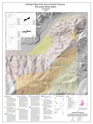
Medium to coarse grained, equigranular, light to medium gray
granitoid. Grain size averages 1 to 3 mm, locally up to 4mm.
Texture is granitic and isotr, except at the contact with the diorite
stock. Near its western margins the granodiorite takes on a
distinct foliation of the biotite that approaches a gneissose
compositional layering.
g Bt Granodiorite (Cretaceous)Kgd
T Diabase Dikes (Miocene)Tdd
Diabase/basalt – Dark gray to black, fine grained to aphanitic, tan
to reddish brown on aphanitic, weathered or altered surfaces. The
diabase is the only dike variety in the area that contains vesicles
and can be amygdaloidal. Amygdules are 2-3mm wide, common-
ly calcite filled and occasionally quartz filled. The ground mass is
dominantly plagioclase, pyroxene, and amphibole. Phenocrysts
are of the same composition as the groundmass and typically
2-4mm long, however the rock is not obviously porphyritic.
The diabase dikes have two mapped occurrences in the area; in
both instances they trend ENE and dip ~40°. The northern of the
two dikes dips to the north while the southern dike dips to the
south. Both are 4-5m thick and exhibit vesicles or amygdules
along their margins. Basalt dikes in the area are aphanitic and
highly altered, much thinner, typically 50cm or less, trend NNE,
and do not contain vesicles. Basalt dikes closely resemble the
highly weathered andesite dikes.
Rhyolite Dikes (Eocene)Trp
Light gray to pinkish brown on fresh surfaces, reddish brown to
brown on weathered surfaces, aphanitic groundmass, phenocrysts
are approximately 40% feldspar, 40% quartz, 10% biotite, and
10% hornblende. Phenocrysts of feldspar are up to 15mm long
and 5mm wide, but most commonly <3mm. Feldspars are tabular
to equant, and often embayed. Phenocrysts of quartz are 2 to 6
mm in diameter, occasionally up to 11mm. The quartz occurs as
rounded grains with translucent rims and opaque, light tan
interiors. Biotite crystals are 2-3mm in diameter, black, hexagonal
or tabular, and often extensively altered to chlorite. Hornblende
phenocrysts are 1-3 mm wide and up to 5mm long, black, and
tabular to rounded in morphology.
The rhyolite dikes do not cut any other dike facies, although in
the Boise Basin Anderson (1947) noted that they are crosscut by
lamprophyre dikes in underground workings. Outcrops of rhyolite
are typically more ledge forming than any other dike series in the
area and traceable over greater distances. Rhyolite dikes are up to
5m in width and trend northeast. The strikes of the dikes are
unaffected by topography, therefore dips are thought to be steep.
The largest rhyolite dikes are extensively altered, suggesting
emplacement before the last hydrothermal event. Geochronologic
work completed as part of this study returned an age of 47.83
±0.56 Ma. Age was obtained using LA-ICPMS on U/Pb in zircon
at the Isotope Geology laboratory at Boise State University.
Unit Descriptions Ta Andesite Dikes (Oligocene)Tad
Light to dark gray on fresh surfaces, weathered surfaces are
typically light to medium gray or greenish gray. Most commonly
the andesite is aphyric and badly weathered in outcrop and hand
sample. Outcrops are generally friable and break with a splintery
fracture. The dikes may contain phenocrysts of small, 1-2mm
feldspars or rounded 2-4mm quartz grains. Where dark colored,
the andesite closely resembles the diorite porphyry, especially
when containing feldspar phenocrysts or in areas where there is
fresh exposure. Weathered outcrops can closely resemble the
weathered basalt/diabasic dikes or the weathered or hydrother-
mally altered diorite porphyry dikes. The dikes are typically
narrow, 1-2 meters. As the strikes of the dikes are unaffected by
topography, dips are thought to be steep.
Field identification was based on presence or absence of
phenocrysts to help distinguish from the diorite porphyry, the
presence or absence of vesicles to help distinguish from the basalt
or diabase, and the friable or splintery nature of the outcrop. Field
identification of aphanitic, dark colored rocks was often difficult.
Additionally, the andesite dikes occasionally contain quartz
phenocrysts that appear to have been entrained from the
surrounding granodiorite during emplacement.
Geochronologic work completed as part of this study returned an
age of 31.15 ±0.83 Ma. Age was obtained using LA-ICPMS on
U/Pb in zircon at the Isotope Geology Lab at Boise State Univer-
sity.
Medium to dark gray or black, tan to greenish weathered faces, 5
to 20% phenocrysts, very fine grained to medium-grained ground
mass. Phenocrysts are dominantly feldspar. Potassium feldspars
are ≤10 mm wide and rounded and embayed. Plagioclase
feldpsars are smaller but typically more numerous and can be up
to 5mm long and 2mm wide. Plagioclase is euhedral to subhedral
and typically tabular. Pyroxenes constitute 5 to 10% of
phenocrysts and are typically 0.5 to 1mm in width, amorphous in
shape, and black in color. Hornblende phenocrysts are black to
dark greenish gray, up to 5mm long and 2-3 mm wide, euhedral,
approaching tabular, and comprise 5 to 10% of the rock. The only
phenocrysts that can be consistently identified in the field are the
conspicuously lighter colored feldspars in a dark gray to black
aphanitic groundmass. Pyrite is locally found as 2-3 mm inclu-
sions in the porphyritic feldspars as well as smaller, 1-2mm
grains in the aphanitic groundmass.
Diorite porphyry is the most common dike lithology in the area.
Field classification was based on the presence of feldspar
phenocrysts in an outcrop that could be traced for a few tens of
meters and/or lithologically similar outcrops along the same trend
in the vicinity. Mapping of some andesite or diabase dikes as
diorite porphyry is possible because field identification of one
dark gray to black, aphanitic lithology from another was often
difficult. The dikes generally trend to the northeast, dip predomi-
nantly south between 75-85°, and range in width from tens of
centimeters to greater than 5 meters, 1-2 meter thick dikes being
the mode. Geochronologic work completed as part of this study
returned ages of 47.37 ±0.68 to 49.39 ±0.70 Ma. The diorite
porphyry is considered penecontemporaneous with all other
Eocene dike phases. Ages were obtained using LA-ICPMS on
U/Pb in zircon at the Isotope Geology Laboratory at Boise State
University.
di Px-hbl Diorite Porphyry (Eocene)TdipLamprophyre (Miocene)Tld
Medium grained, brown, mafic, feldspathic, micaceous, idiomor-
phic, and friable. Biotite and phlogopite comprise > 90% of the
rock in hand sample, with scattered feldspars comprising the
remaining 5%. All grains are less than 1mm in diameter, biotite
is euhedral and feldspar equant.
The lamprophyre outcrops extremely poorly, the one mapped
instance trends NNE at the bottom of a recently washed out
gully. The dike is emplaced along preexisting anastomosing and
en-echelon shears in the granodiorite. No contacts with other
dikes are observed in this locality. In the Boise Basin lampro-
phyres are observed cutting all Eocene dike lithologies (Ander-
son, 1947).
Payette Formation (Miocene)Tpf
Well sorted silt, sand, and gravel, angular to moderately rounded,
poorly to well indurated. Not studied as part of this project
beyond cursory examination. Alternating beds of silicified
arkosic sandstone and slope-forming shales. Locally, beds dip to
the west or southwest and are in fault contact with the Idaho
Batholith along the eastern margin of the property. Described by
Lindgren (1898); no type locality given. Forester et al. (2002)
dated an intercalated ash bed and report an age of 11.8 ± 0.2 Ma.
Tdu Dikes, undivided (Eocene)
Dikes of uncertain composition, most are probably rhyolite or
dacite porphyry. They are, in general, very fine grained, however,
granophyric textures are also present.
1:4,000
Scale
Geologic Map of the Trans-Challis Property
Horseshoe Bend, Idaho
Josh Ekhoff
2016
Distinctly porphyritic, medium gray to light gray, contains up to
80% phenocrysts in an aphanitic groundmass. Roughly 60% of
the phenocrysts are prismatic, tabular plagioclase feldspar
crystals up to 10 mm long and 5 mm wide. In hand sample the
feldspars often exhibit zoning from core to rim, with translucent
white to pink cores and opaque white to tan rims. Euhedral
hexagonal biotite crystals up to 3 mm in diameter make up ~20%
of the phenocrysts; on weathered faces the biotite often leaves
hexagonal voids. The remaining 20% of phenocrysts are a
blue-green to black amphibole, likely hornblende. Hornblende
can be up to 10 mm long and 2 mm wide. Rounded quartz
phenocrysts are locally present.
Dacite dikes are typically 3-5 meters wide and trend E-W.
Outcrops tend to be expressed as zones of dacite rubble. The
dacite is crosscut by diorite porphyry and crosscuts the diorite
stock to granodiorite contact, but is not observed crosscutting any
other dike facies. The dikes are often altered or bleached where
they contact other dike facies. The strikes of the dikes appear
unaffected by topography, therefore dips are thought to be steep.
Geochronologic work completed as part of this study returned an
age of 48.65 ±0.78 Ma. Age was obtained using LA-ICPMS on
U/Pb in zircon at the Isotope Geology Laboratory at Boise State
University.
Bt-hbl Dacite Porphyry Dikes (Eocene)Tdp
Structure
Normal Fault (unnamed)
Normal Fault (unnamed) - A northeast trending fault separates
the intrusive rocks of the Cretaceous Idaho Batholith and the
Eocene Idaho Porphyry Belt from the Miocene lake sediments of
the Payette Formation along the eastern margin of the property.
Sedimentary beds within the Payette Formation dip to the west
and southwest indicating fault block tilting during extensional,
graben forming movement along the fault. No marker beds are
present along footwall of the fault to indicate sense of movement,
though offset dikes within the Idaho Batholith may be due to
some strike/slip movement associated with movement along the
normal fault.
Gouge and shear zones
Within the Cretaceous granodiorite and diorite there are two
prominent sets of shear and gouge zones. One set trends north-
east and is roughly parallel to sub-parallel to the overall north-
east trend of the dikes in the area. The other major set trends
NNW and does not appear to be in conjunction with any major
feature through the area.
Alluvium (Holocene)Qal
Sand, gravel, cobbles, and boulders eroded from granitic and
dioritic valley walls and included dikes. Deposited where stream
volume and/or gradient could not support the material as suspend-
ed or bed load; such as the meanders on which the mapped
alluvium sits. Deposits are along modern margins of the Payette
River and on a river cut bench adjacent to property. Current terrace
is a mix of alluvium from stream sediment transport and colluvium
from the hills above. Near the contact with the Tertiary Diorite
stock the particles become increasingly angular.
Symbols
Mine Dump
Unimproved Road
Mine entrance (abandoned)
Baseline
Mineralized vein
Strike and dip of mineralized vein
Strike and dip of joints
Abandoned prospect pits
Approximate contact
Strike and dip of lithology
o
Strike of lithology
Ý
Granodiorite or diorite with gneissic texture¨
Strike and dip of joints
Ä
Strike and dip of shear or gouge zone
º
Strike of shear or gouge zone
©
Gouge or shear zone; strike and dip undeterminedÔ
Strike and dip of slip surface
j
½
Ì
ÝoÂ
Normal Fault, ball on downthrown side
Fine to coarse grained, equigranular, mottled white and black to
black granitoid. Mafic minerals are primarily hornblende with
subordinate biotite; felsic minerals are dominantly plagioclase
with subordinate potassium feldspar and quartz.
The diorite stock covers roughly the western half of the map area
and, with reference to larger scale maps produced by the Idaho
Geologic Survey, is overall elongate to the northeast. The contact
with the granodiorite to the east is marked by a gneissose fabric
and trends northeast-southwest in a stair step fashion, with
north-trending zones of shear.
Hbl-bt Diorite (Cretaceous)Kdi
CORRELATION OF MAP UNITS
g
Kgd
Qal
Kdi
Tdd
Tld
Tad
Trp
Tdp
Tdip Tdu
Tpf
HoloceneMioceneOligoceneEocene
QUATERNARYTERTIARYCRETACEOUS
APEX Mining Claims
1000’ (305m) S
N
N
N
Stereonet showing the
poles to plane of
fractures. “Fractures”
here refers to planes
that contain indicators
for minor dip-slip
movement. Only
measurements for
fractures with move-
ment indicators are
shown. The majority of
points indicate north-
east to east-west
trending fractures, a
potentially significant
set of points indicate a
conjugate subset of
northwest trending
fractures. Mean vector
denoted by black
square with error
indicate by unfilled
circle. Data from 2015
geologic mapping
program.
Stereonet showing the
pole to planes of
measured vein strike
and dips. The under-
ground data from
Anderson (1934)
includes workings
across the breadth of
the Pearl to horseshoe
Bend districts and is
plotted in red, surface
data from this study is
plotted in black. Mean
vetors are Red and
black squares.
Stereonet showing
poles to planes of dikes
strike and dips
measured as part of this
study as small filled
circles. Mean vector
orientations are the
larger filled circles,
error on the mean
shown as large unfilled
ellipses. Red: diorite
porphyry dikes, blue:
andesite dikes, green:
diabase dikes, light
blue: dacite dikes,
orange: rhyolite dikes.
55 1010 1515 2020 2525 3030
N = 292
1010 2020 3030 4040
N = 13
N
E
S
W
0
60
30
90
Rose diagram showing
the orientation
measurements of dikes
where a reliable dip
measurement was
unavailable. The large
majority of dikes are
oriented between 50
and 70 degrees Dikes
are not divided by
lithology in this figure.
Rose diagram showing
the orientation of veins
from this study where
dip was unable to be
determined.
Dikes
Veins
Fractures
250 0 250 500125
Meters
500 0 500 1,000250
Feet
0 0.25 0.50.125
Miles
UTM Grid North and Magnetic North
declination at center of map
$¡
GN MN
at
:
Coordinate System: NAD 1983 UTM Zone 11N
Projection: Transverse Mercator
D um: North American 1983
False Easting 500,000.0000
False Northing: 0.0000
Central Meridian: -117.0000
Scale Factor: 0.9996
Latitude Of Origin: 0.0000
Units: Meter
13.67°
$ 150
Horseshoe
Bend
Boise
Kgd
Tcv
Location of Horseshoe Bend and Trans-Challis LLC. property
in relation to Cretaceous Idaho batholith (Kgd, pink), Eocene
Challis volcanics (Tcv, orange), and Trans-Challis Fault Zone
(black lines). Red polygon outlines Boise County.
Tpf
Kgd
Kgd
Kdi
Qal
Tdip
Tdip
Tdip
Tdip
Tdip
Tdip
Tdip
Tdip
Tdip
Tdip
Tdip
Tdip
Tdip
Tdip
Tdip
Tdip
Tdip
Tdip
Trp
Tdip
Tdip
Tdip
Tdip
Tdip
Trp
Trp
Tdip
Tdip
Tdip
Tdip
Tdip
Tdip
Tdip
Tdip
Tdip
Tdip
Tdp
Tdp
Tdip
Tdip
Tdip
Tdip
Tdip
Tdip
Tdip
Tdip
Tdip
Tdip
Tdip
Tdp
Tad
TdipTdip
Trp
Tdip
Tdip
Tdip
Tdd
Tdip
Tad
Tdip
Tdip
Tdip
Tdip
Tdip
Tdip
Tdip
Tdip
Tad
Tdip
Tdip
Tdip
Tdip
Tdip
Tdip
Tdip
Tdip
Tdip
Tdip
Tdip
Tdip
Tdip
Tdip
Tdp
Tdp
Tdp
Tdip
Tdip
Tad
Tdip
Tdip
Tdip
Tdip
Tdip
Tdip
Tdip
Tad
Tad
Tdip
Tdip
Tdip
Tdd
Tdd
TddTld
Tdip
Tdip
Tdip
Tdip
Tdip
Tdip
Tdip
Tdip
Tad
Tad
Tad
Tad
Tad
Tad
Tdip
Tdip
Tdip
Tdip
Tdip
Tdip
Tdip
Tad
Trp
Tad
Tad
Tad
Tad
Tdu
Tad
Tdip
Tdip
Tdip
Tdip
Tdip
Tad
Tad
Tad
Tad
Tad
Tdip
Tdip
Tdip
Tdip
Tdip
Tdd
Tdip
APEX
MAMMOTH
CATHERINEQUAKER
PAYETTE
KENTUCK
OG01
OG02
OG03
OG04
OG05
OG06
OG07
OG08
OG09
OG10
OG11
OG12
OG13
OG14
OG15
OG16
OG17OG18OG19OG20OG21OG22OG23
OG24
030405
28 27
32 3433
116°13'0"W
116°13'0"W
116°13'30"W
116°13'30"W
116°14'0"W
116°14'0"W
116°14'30"W
116°14'30"W
43°54'30"N
43°54'30"N
43°54'0"N
43°54'0"N
43°53'30"N
43°53'30"N
560250
560250
560500
560500
560750
560750
561000
561000
561250
561250
561500
561500
561750
561750
562000
562000
562250
562250
562500
562500
562750
562750
563000
563000
563250
563250
563500
563500
4859750
4859750
4860000
4860000
4860250
4860250
4860500
4860500
4860750
4860750
4861000
4861000
4861250
4861250
4861500
4861500
4861750
4861750
4862000
4862000
4862250
4862250
4862500
4862500
4862750
4862750
R02E
R02E
T06T07
T06T07