SlideShare a Scribd company logo
1 of 1
Download to read offline
Ø AIRS-suite and CrIMSS are IR+MW hyperspectral sounder suites.
ØBoth are in 1:30 PM ascending sun-synchronous orbits
ØThe orbits match well for several hours every 2.667 days
ØWe concentrate on data from 2014-02-01, within 1 hour of the coincidence near T06Z
(AIRS granule 60). Here the tracks match well and CrIMSS observations are about 15
minutes earlier than AIRS-suite.
ØAIRS-suite launched on EOSAqua in 2002 and is nearing the end of its operational life
ØThe first CrIMSS launched on Suomi NPP in 2011 and further launches are planned on
JPSS platforms
ØWe wish to study the possibility of creating a continuous cloud product from these
missions.
Ø Key instrument differences:
ØIR:
ØAIRS is a grating spectrometer, with separate detectors per frequency but the same
detectors for all locations
ØCrIS is an interferometer. It has separate detectors for 3 bands x 9 fields of view
ØMW:
ØAIRS-suite includes MW temperature and water vapor sounders.
ØFor the period in question the MW sounder has failed and the temperature sounder
has suffered substantial losses
ØCrIMSS includes ATMS, a fully operational temperature and water vapor sounder
Ø Both are processed with similar “v6.22” algorithms from NASAGSFC SRT
ØBoth produce T, q, O3, surface, … cloud parameters
ØThere are subtle but important differences between the two algorithm versions.
Authors
Conclusions
AIRS & CrIMSS Cloud Products
AIRS-Suite Clouds CrIMSS CloudsAbstract Locations of Sample Data
3D Visual Comparison of AIRS-suite and CrIMSS Clouds
Evan M. Manning1, Charles K. Thompson1, John Pham2, Brian H. Kahn1, Oleg Pariser1,
Hartmut H. Aumann1
AGU Fall Meeting, San Francisco, December 2016
Clouds have a great deal of complexity in spatial and spectral/compositional dimensions.
Modeled and retrieved clouds have to make simplifications, and the detailed implications of of
these simplifications can be difficult to discern. We show how three-dimensional visualizations
can aid in comparing clouds retrieved by AIRS-suite and CrIMSS Level 2.
1 Jet Propulsion Laboratory, California Institute of Technology
2 University of California, Riverside
AIRS-Suite and CrIMSS
Ø The GSFC SRTAIRS & CrIMSS products include several cloud parameters among their
many retrieval products
Ø The cloud retrieval reports effective cloud fraction (EFC) and cloud top pressure (CTP) for up
to 2 cloud layers in each 15+ km spot
References
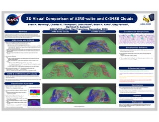
Ø 3D visualizations of clouds make it easy to pick out patterns in differences.
ØThese differences must then be verified with statistics
Ø Significant additional work is needed before a continuous long-term record of clouds can
be made fromAIRS and CrIMSS products.
Miller, S. D., and Coauthors, 2014: Estimating three-dimensional cloud structure via
statistically blended satellite observations. J. Appl. Meteor. Climatol., 53, 437–455,
doi:10.1175/JAMC-D-13-070.1.
A21A-0003
Visualization Approach
Ø Clouds are modelled as opaque solid cylinders, roughly
filling the field-of-view of the instrument.
ØFields of view are adjusted to limit overlap
Ø The area of each cloud is adjusted to match the reported
ECF
ØKeeping the horizontal shape constant, the radius is
multiplied by sqrt(ECF)
Ø Depth is based on Miller et al. Cloudsat-derived
climatology of cloud thickness by cloud type
ØFor Dc and Ns, we modify this to put the cloud bottom
0.5 km above the surface
ØFor cloud type determination, we use IR CTP and IR
ECF
ØThe upper cloud is reduced when the clouds overlap
vertically
ØVertical coordinates are magnified 10-15x for display
Ø Clouds are colored based on cloud top height
Granule 61
Nighttime Caribbean
Granule 57
Daytime Arctic
Location of daytime granules 2014-02-01 Location of nighttime granules 2014-02-01
Ø There are regions where CrIMSS detects low clouds but AIRS-suite does not.
Ø There are regions where CrIMSS shows systematic differences in cloudiness among its 9
FOVs.
Ø There are regions where the CrIMSS retrieval detects thin high clouds but the AIRS-suite
retrieval does not.
Ø There are regions where the AIRS retrieval sees a single cloud layer but the CrIMSS
retrieval system sees two distinct layers.
Sample clouds colored by cloud type
Differences Found
Granule 56
Daytime Siberia
Visualization Software
Ø Python is used to read HDFAIRS data and netCDF4 CrIMSS data, and to process it to
determine display shapes and colors.
Ø Open-source game engine Blender is used to create objects and render images and
animations
ØPython calls Blender via the bpy module.
Ø Objects are also exported from Blender to the Unity game engine for interactive use on
interactive WebGL websites and VR goggles.
© 2016. All rights reserved.
More Related Content

What's hot

WE2.L09 - DESDYNI LIDAR FOR SOLID EARTH APPLICATIONS
WE2.L09 - DESDYNI LIDAR FOR SOLID EARTH APPLICATIONSWE2.L09 - DESDYNI LIDAR FOR SOLID EARTH APPLICATIONS
WE2.L09 - DESDYNI LIDAR FOR SOLID EARTH APPLICATIONSgrssieee
 
Mapping of the_extinction_in_giant_molecular_clouds_using_optical_star_counts
Mapping of the_extinction_in_giant_molecular_clouds_using_optical_star_countsMapping of the_extinction_in_giant_molecular_clouds_using_optical_star_counts
Mapping of the_extinction_in_giant_molecular_clouds_using_optical_star_countsSérgio Sacani
 
เศรษฐกิจพอเพียง
เศรษฐกิจพอเพียง เศรษฐกิจพอเพียง
เศรษฐกิจพอเพียง evesudarat
 
Kvt mapping of_icing
Kvt mapping of_icingKvt mapping of_icing
Kvt mapping of_icingWinterwind
 
2 Prelaunch Assessment of the NG VCM.pptx
2 Prelaunch Assessment of the NG VCM.pptx2 Prelaunch Assessment of the NG VCM.pptx
2 Prelaunch Assessment of the NG VCM.pptxgrssieee
 
Parametric Time Domain Method for separation of Cloud and Drizzle for ARM Clo...
Parametric Time Domain Method for separation of Cloud and Drizzle for ARM Clo...Parametric Time Domain Method for separation of Cloud and Drizzle for ARM Clo...
Parametric Time Domain Method for separation of Cloud and Drizzle for ARM Clo...Pratik Ramdasi
 
Robust registration of cloudy satellite images using two step segmentation
Robust registration of cloudy satellite images using two step segmentationRobust registration of cloudy satellite images using two step segmentation
Robust registration of cloudy satellite images using two step segmentationI3E Technologies
 
GPS [ Global Positioning System ]
GPS [ Global Positioning System ]GPS [ Global Positioning System ]
GPS [ Global Positioning System ]Akshit Gupta
 
4_Presentation.DE+EnVA.20110727.ppt
4_Presentation.DE+EnVA.20110727.ppt4_Presentation.DE+EnVA.20110727.ppt
4_Presentation.DE+EnVA.20110727.pptgrssieee
 
How GPS works
How GPS worksHow GPS works
How GPS worksAmit Garg
 
Pulvirenti_IGARSS2011.ppt
Pulvirenti_IGARSS2011.pptPulvirenti_IGARSS2011.ppt
Pulvirenti_IGARSS2011.pptgrssieee
 
Ieee gold angiati
Ieee gold angiatiIeee gold angiati
Ieee gold angiatigrssieee
 
zhu_et_al_IGARSS2011_time_warp.ppt
zhu_et_al_IGARSS2011_time_warp.pptzhu_et_al_IGARSS2011_time_warp.ppt
zhu_et_al_IGARSS2011_time_warp.pptgrssieee
 
A2 Knútur Árnason The DRG seismic experiment in Krafla ​
A2 Knútur Árnason The DRG seismic experiment in Krafla ​A2 Knútur Árnason The DRG seismic experiment in Krafla ​
A2 Knútur Árnason The DRG seismic experiment in Krafla ​GEORG Geothermal Workshop 2016
 
061018 Sea Wi Fs Work
061018 Sea Wi Fs Work061018 Sea Wi Fs Work
061018 Sea Wi Fs WorkRudolf Husar
 
2011IgarssMetaw.ppt
2011IgarssMetaw.ppt2011IgarssMetaw.ppt
2011IgarssMetaw.pptgrssieee
 

What's hot (17)

WE2.L09 - DESDYNI LIDAR FOR SOLID EARTH APPLICATIONS
WE2.L09 - DESDYNI LIDAR FOR SOLID EARTH APPLICATIONSWE2.L09 - DESDYNI LIDAR FOR SOLID EARTH APPLICATIONS
WE2.L09 - DESDYNI LIDAR FOR SOLID EARTH APPLICATIONS
 
Mapping of the_extinction_in_giant_molecular_clouds_using_optical_star_counts
Mapping of the_extinction_in_giant_molecular_clouds_using_optical_star_countsMapping of the_extinction_in_giant_molecular_clouds_using_optical_star_counts
Mapping of the_extinction_in_giant_molecular_clouds_using_optical_star_counts
 
Rocca.ppt
Rocca.pptRocca.ppt
Rocca.ppt
 
เศรษฐกิจพอเพียง
เศรษฐกิจพอเพียง เศรษฐกิจพอเพียง
เศรษฐกิจพอเพียง
 
Kvt mapping of_icing
Kvt mapping of_icingKvt mapping of_icing
Kvt mapping of_icing
 
2 Prelaunch Assessment of the NG VCM.pptx
2 Prelaunch Assessment of the NG VCM.pptx2 Prelaunch Assessment of the NG VCM.pptx
2 Prelaunch Assessment of the NG VCM.pptx
 
Parametric Time Domain Method for separation of Cloud and Drizzle for ARM Clo...
Parametric Time Domain Method for separation of Cloud and Drizzle for ARM Clo...Parametric Time Domain Method for separation of Cloud and Drizzle for ARM Clo...
Parametric Time Domain Method for separation of Cloud and Drizzle for ARM Clo...
 
Robust registration of cloudy satellite images using two step segmentation
Robust registration of cloudy satellite images using two step segmentationRobust registration of cloudy satellite images using two step segmentation
Robust registration of cloudy satellite images using two step segmentation
 
GPS [ Global Positioning System ]
GPS [ Global Positioning System ]GPS [ Global Positioning System ]
GPS [ Global Positioning System ]
 
4_Presentation.DE+EnVA.20110727.ppt
4_Presentation.DE+EnVA.20110727.ppt4_Presentation.DE+EnVA.20110727.ppt
4_Presentation.DE+EnVA.20110727.ppt
 
How GPS works
How GPS worksHow GPS works
How GPS works
 
Pulvirenti_IGARSS2011.ppt
Pulvirenti_IGARSS2011.pptPulvirenti_IGARSS2011.ppt
Pulvirenti_IGARSS2011.ppt
 
Ieee gold angiati
Ieee gold angiatiIeee gold angiati
Ieee gold angiati
 
zhu_et_al_IGARSS2011_time_warp.ppt
zhu_et_al_IGARSS2011_time_warp.pptzhu_et_al_IGARSS2011_time_warp.ppt
zhu_et_al_IGARSS2011_time_warp.ppt
 
A2 Knútur Árnason The DRG seismic experiment in Krafla ​
A2 Knútur Árnason The DRG seismic experiment in Krafla ​A2 Knútur Árnason The DRG seismic experiment in Krafla ​
A2 Knútur Árnason The DRG seismic experiment in Krafla ​
 
061018 Sea Wi Fs Work
061018 Sea Wi Fs Work061018 Sea Wi Fs Work
061018 Sea Wi Fs Work
 
2011IgarssMetaw.ppt
2011IgarssMetaw.ppt2011IgarssMetaw.ppt
2011IgarssMetaw.ppt
 

Similar to Manning_3D_Cloud_AGU_Poster

1 IGARSS 2011 JPSS Monday Goldberg.pptx
1 IGARSS 2011 JPSS Monday Goldberg.pptx1 IGARSS 2011 JPSS Monday Goldberg.pptx
1 IGARSS 2011 JPSS Monday Goldberg.pptxgrssieee
 
Use of mesoscale modeling to increase the reliability of wind resource assess...
Use of mesoscale modeling to increase the reliability of wind resource assess...Use of mesoscale modeling to increase the reliability of wind resource assess...
Use of mesoscale modeling to increase the reliability of wind resource assess...Jean-Claude Meteodyn
 
3D Cloud Visualizations
3D Cloud Visualizations3D Cloud Visualizations
3D Cloud VisualizationsJohn Pham
 
TU2.T10.2.ppt
TU2.T10.2.pptTU2.T10.2.ppt
TU2.T10.2.pptgrssieee
 
SPACEBORNE_MICROWAVE_OBSERVATIONS_OF_RAIN 1972-1997.ppt
SPACEBORNE_MICROWAVE_OBSERVATIONS_OF_RAIN 1972-1997.pptSPACEBORNE_MICROWAVE_OBSERVATIONS_OF_RAIN 1972-1997.ppt
SPACEBORNE_MICROWAVE_OBSERVATIONS_OF_RAIN 1972-1997.pptgrssieee
 
SPACEBORNE_MICROWAVE_OBSERVATIONS_OF_RAIN 1972-1997.ppt
SPACEBORNE_MICROWAVE_OBSERVATIONS_OF_RAIN 1972-1997.pptSPACEBORNE_MICROWAVE_OBSERVATIONS_OF_RAIN 1972-1997.ppt
SPACEBORNE_MICROWAVE_OBSERVATIONS_OF_RAIN 1972-1997.pptgrssieee
 
SPACEBORNE_MICROWAVE_OBSERVATIONS_OF_RAIN 1972-1997.ppt
SPACEBORNE_MICROWAVE_OBSERVATIONS_OF_RAIN 1972-1997.pptSPACEBORNE_MICROWAVE_OBSERVATIONS_OF_RAIN 1972-1997.ppt
SPACEBORNE_MICROWAVE_OBSERVATIONS_OF_RAIN 1972-1997.pptgrssieee
 
AGU - DEC 2015 - Point Grey Poster-Nov112015
AGU - DEC 2015 - Point Grey Poster-Nov112015AGU - DEC 2015 - Point Grey Poster-Nov112015
AGU - DEC 2015 - Point Grey Poster-Nov112015Allison Westin, G.I.T.
 
WE4.L10.5: ADVANCES IN NIGHTTIME SATELLITE REMOTE SENSING CAPABILITIES VIA TH...
WE4.L10.5: ADVANCES IN NIGHTTIME SATELLITE REMOTE SENSING CAPABILITIES VIA TH...WE4.L10.5: ADVANCES IN NIGHTTIME SATELLITE REMOTE SENSING CAPABILITIES VIA TH...
WE4.L10.5: ADVANCES IN NIGHTTIME SATELLITE REMOTE SENSING CAPABILITIES VIA TH...grssieee
 
Aircraft operational procedures rev1_
Aircraft operational procedures rev1_Aircraft operational procedures rev1_
Aircraft operational procedures rev1_rainman999
 
RE.SUN Validation (March 2013)
RE.SUN Validation (March 2013)RE.SUN Validation (March 2013)
RE.SUN Validation (March 2013)Carlos Pinto
 
2_Chinnawat_IGARSS11_711B.ppt
2_Chinnawat_IGARSS11_711B.ppt2_Chinnawat_IGARSS11_711B.ppt
2_Chinnawat_IGARSS11_711B.pptgrssieee
 
WARRP Seismology: Better Imaging Under Earth
WARRP Seismology: Better Imaging Under EarthWARRP Seismology: Better Imaging Under Earth
WARRP Seismology: Better Imaging Under EarthAli Osman Öncel
 
EGU21-11075_presentation.pptx
EGU21-11075_presentation.pptxEGU21-11075_presentation.pptx
EGU21-11075_presentation.pptxssusercd49c0
 
Future guidelines the meteorological view - Isabel Martínez (AEMet)
Future guidelines the meteorological view - Isabel Martínez (AEMet)Future guidelines the meteorological view - Isabel Martínez (AEMet)
Future guidelines the meteorological view - Isabel Martínez (AEMet)IrSOLaV Pomares
 
Remote sensing - Scanners
Remote sensing - ScannersRemote sensing - Scanners
Remote sensing - ScannersPramoda Raj
 

Similar to Manning_3D_Cloud_AGU_Poster (20)

1 IGARSS 2011 JPSS Monday Goldberg.pptx
1 IGARSS 2011 JPSS Monday Goldberg.pptx1 IGARSS 2011 JPSS Monday Goldberg.pptx
1 IGARSS 2011 JPSS Monday Goldberg.pptx
 
Use of mesoscale modeling to increase the reliability of wind resource assess...
Use of mesoscale modeling to increase the reliability of wind resource assess...Use of mesoscale modeling to increase the reliability of wind resource assess...
Use of mesoscale modeling to increase the reliability of wind resource assess...
 
3D Cloud Visualizations
3D Cloud Visualizations3D Cloud Visualizations
3D Cloud Visualizations
 
TU2.T10.2.ppt
TU2.T10.2.pptTU2.T10.2.ppt
TU2.T10.2.ppt
 
SPACEBORNE_MICROWAVE_OBSERVATIONS_OF_RAIN 1972-1997.ppt
SPACEBORNE_MICROWAVE_OBSERVATIONS_OF_RAIN 1972-1997.pptSPACEBORNE_MICROWAVE_OBSERVATIONS_OF_RAIN 1972-1997.ppt
SPACEBORNE_MICROWAVE_OBSERVATIONS_OF_RAIN 1972-1997.ppt
 
SPACEBORNE_MICROWAVE_OBSERVATIONS_OF_RAIN 1972-1997.ppt
SPACEBORNE_MICROWAVE_OBSERVATIONS_OF_RAIN 1972-1997.pptSPACEBORNE_MICROWAVE_OBSERVATIONS_OF_RAIN 1972-1997.ppt
SPACEBORNE_MICROWAVE_OBSERVATIONS_OF_RAIN 1972-1997.ppt
 
SPACEBORNE_MICROWAVE_OBSERVATIONS_OF_RAIN 1972-1997.ppt
SPACEBORNE_MICROWAVE_OBSERVATIONS_OF_RAIN 1972-1997.pptSPACEBORNE_MICROWAVE_OBSERVATIONS_OF_RAIN 1972-1997.ppt
SPACEBORNE_MICROWAVE_OBSERVATIONS_OF_RAIN 1972-1997.ppt
 
AGU - DEC 2015 - Point Grey Poster-Nov112015
AGU - DEC 2015 - Point Grey Poster-Nov112015AGU - DEC 2015 - Point Grey Poster-Nov112015
AGU - DEC 2015 - Point Grey Poster-Nov112015
 
WE4.L10.5: ADVANCES IN NIGHTTIME SATELLITE REMOTE SENSING CAPABILITIES VIA TH...
WE4.L10.5: ADVANCES IN NIGHTTIME SATELLITE REMOTE SENSING CAPABILITIES VIA TH...WE4.L10.5: ADVANCES IN NIGHTTIME SATELLITE REMOTE SENSING CAPABILITIES VIA TH...
WE4.L10.5: ADVANCES IN NIGHTTIME SATELLITE REMOTE SENSING CAPABILITIES VIA TH...
 
Aircraft operational procedures rev1_
Aircraft operational procedures rev1_Aircraft operational procedures rev1_
Aircraft operational procedures rev1_
 
RE.SUN Validation (March 2013)
RE.SUN Validation (March 2013)RE.SUN Validation (March 2013)
RE.SUN Validation (March 2013)
 
2_Chinnawat_IGARSS11_711B.ppt
2_Chinnawat_IGARSS11_711B.ppt2_Chinnawat_IGARSS11_711B.ppt
2_Chinnawat_IGARSS11_711B.ppt
 
WARRP Seismology: Better Imaging Under Earth
WARRP Seismology: Better Imaging Under EarthWARRP Seismology: Better Imaging Under Earth
WARRP Seismology: Better Imaging Under Earth
 
EGU21-11075_presentation.pptx
EGU21-11075_presentation.pptxEGU21-11075_presentation.pptx
EGU21-11075_presentation.pptx
 
AIAA Paper dlt228
AIAA Paper dlt228AIAA Paper dlt228
AIAA Paper dlt228
 
Future guidelines the meteorological view - Isabel Martínez (AEMet)
Future guidelines the meteorological view - Isabel Martínez (AEMet)Future guidelines the meteorological view - Isabel Martínez (AEMet)
Future guidelines the meteorological view - Isabel Martínez (AEMet)
 
Astana spherex
Astana spherexAstana spherex
Astana spherex
 
Remote sensing - Scanners
Remote sensing - ScannersRemote sensing - Scanners
Remote sensing - Scanners
 
Aerophysx Brochure
Aerophysx BrochureAerophysx Brochure
Aerophysx Brochure
 
C011121114
C011121114C011121114
C011121114
 

Manning_3D_Cloud_AGU_Poster

  • 1. Ø AIRS-suite and CrIMSS are IR+MW hyperspectral sounder suites. ØBoth are in 1:30 PM ascending sun-synchronous orbits ØThe orbits match well for several hours every 2.667 days ØWe concentrate on data from 2014-02-01, within 1 hour of the coincidence near T06Z (AIRS granule 60). Here the tracks match well and CrIMSS observations are about 15 minutes earlier than AIRS-suite. ØAIRS-suite launched on EOSAqua in 2002 and is nearing the end of its operational life ØThe first CrIMSS launched on Suomi NPP in 2011 and further launches are planned on JPSS platforms ØWe wish to study the possibility of creating a continuous cloud product from these missions. Ø Key instrument differences: ØIR: ØAIRS is a grating spectrometer, with separate detectors per frequency but the same detectors for all locations ØCrIS is an interferometer. It has separate detectors for 3 bands x 9 fields of view ØMW: ØAIRS-suite includes MW temperature and water vapor sounders. ØFor the period in question the MW sounder has failed and the temperature sounder has suffered substantial losses ØCrIMSS includes ATMS, a fully operational temperature and water vapor sounder Ø Both are processed with similar “v6.22” algorithms from NASAGSFC SRT ØBoth produce T, q, O3, surface, … cloud parameters ØThere are subtle but important differences between the two algorithm versions. Authors Conclusions AIRS & CrIMSS Cloud Products AIRS-Suite Clouds CrIMSS CloudsAbstract Locations of Sample Data 3D Visual Comparison of AIRS-suite and CrIMSS Clouds Evan M. Manning1, Charles K. Thompson1, John Pham2, Brian H. Kahn1, Oleg Pariser1, Hartmut H. Aumann1 AGU Fall Meeting, San Francisco, December 2016 Clouds have a great deal of complexity in spatial and spectral/compositional dimensions. Modeled and retrieved clouds have to make simplifications, and the detailed implications of of these simplifications can be difficult to discern. We show how three-dimensional visualizations can aid in comparing clouds retrieved by AIRS-suite and CrIMSS Level 2. 1 Jet Propulsion Laboratory, California Institute of Technology 2 University of California, Riverside AIRS-Suite and CrIMSS Ø The GSFC SRTAIRS & CrIMSS products include several cloud parameters among their many retrieval products Ø The cloud retrieval reports effective cloud fraction (EFC) and cloud top pressure (CTP) for up to 2 cloud layers in each 15+ km spot References Ø 3D visualizations of clouds make it easy to pick out patterns in differences. ØThese differences must then be verified with statistics Ø Significant additional work is needed before a continuous long-term record of clouds can be made fromAIRS and CrIMSS products. Miller, S. D., and Coauthors, 2014: Estimating three-dimensional cloud structure via statistically blended satellite observations. J. Appl. Meteor. Climatol., 53, 437–455, doi:10.1175/JAMC-D-13-070.1. A21A-0003 Visualization Approach Ø Clouds are modelled as opaque solid cylinders, roughly filling the field-of-view of the instrument. ØFields of view are adjusted to limit overlap Ø The area of each cloud is adjusted to match the reported ECF ØKeeping the horizontal shape constant, the radius is multiplied by sqrt(ECF) Ø Depth is based on Miller et al. Cloudsat-derived climatology of cloud thickness by cloud type ØFor Dc and Ns, we modify this to put the cloud bottom 0.5 km above the surface ØFor cloud type determination, we use IR CTP and IR ECF ØThe upper cloud is reduced when the clouds overlap vertically ØVertical coordinates are magnified 10-15x for display Ø Clouds are colored based on cloud top height Granule 61 Nighttime Caribbean Granule 57 Daytime Arctic Location of daytime granules 2014-02-01 Location of nighttime granules 2014-02-01 Ø There are regions where CrIMSS detects low clouds but AIRS-suite does not. Ø There are regions where CrIMSS shows systematic differences in cloudiness among its 9 FOVs. Ø There are regions where the CrIMSS retrieval detects thin high clouds but the AIRS-suite retrieval does not. Ø There are regions where the AIRS retrieval sees a single cloud layer but the CrIMSS retrieval system sees two distinct layers. Sample clouds colored by cloud type Differences Found Granule 56 Daytime Siberia Visualization Software Ø Python is used to read HDFAIRS data and netCDF4 CrIMSS data, and to process it to determine display shapes and colors. Ø Open-source game engine Blender is used to create objects and render images and animations ØPython calls Blender via the bpy module. Ø Objects are also exported from Blender to the Unity game engine for interactive use on interactive WebGL websites and VR goggles. © 2016. All rights reserved.