10. Conclusions
• Production data supports higher Avalon initial rates and higher estimated
ultimate recoveries in specific Avalon zones with thicker log porosity above 16
percent and covering larger map areas.
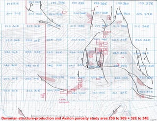
• Detailed correlation and mapping of Avalon porosity distribution defines the
production sweet spots for offset infill drilling and explains poor recovery from
wells in thin porosity areas or small porosity pods that drain smaller map areas.
• A gross interval series of Avalon porosity thick trends oriented from NW-SE
indicate deposition sourced from structural highlands to the NW.
• Porosity logs in pilot holes prior to horizontal wells or older wells that tested
deeper structures are crucial for mapping the complex porosity thick trends
within the Avalon and maximizing the Avalon play economics.