
Recommended
More Related Content
Viewers also liked
Viewers also liked (15)
Similar to Automates Spatial Data Searches with DataBuffer Tool
Similar to Automates Spatial Data Searches with DataBuffer Tool (20)
Automates Spatial Data Searches with DataBuffer Tool
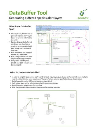
- 1. DataBuffer Tool Generating buffered species alert layers What is the DataBuffer Tool? An easy to use, flexible tool to generate ‘species alert’ layers based on species data held by the LERC Species data can be buffered, combined and dissolved as required to create data that is easy for partners to use and interpret Fully integrated into your GIS system as a menu item Fully configurable to suit your organisation’s requirements Compatible with MapInfo (ArcGIS and QGIS versions can be developed) What do the outputs look like? In order to simplify large numbers of records for each input layer, outputs can be ‘Combined’ when multiple records exist within the same location, or ‘Clustered’ when within a specified distance of each other Spatial output in native GIS format (platform dependent) Each output layer can be fully configured with custom symbology Spatial output is added to the GIS interface A log file automatically documents the process for auditing purposes
- 2. Automates spatial data searches How does it work? The tool integrates with your GIS, where it accesses the data layers you wish to use A log file is kept of the process Information about how to buffer and cluster the data layer is contained in an XML configuration document. This information includes: • Which data layers to make available • Which columns to include in the output layer • Subsets of records to include or exclude from each data layer • Which columns to group the records by in the output layer • Buffer distances and dissolve distances for each data layer • Symbology to apply to the output layer Data Buffer ToolGIS System Data layers Spatial output XML Configuration What are the advantages to me? Save time through the automation of a routine manual task Standardise the process as well as the outputs, reducing the risk of user error Obtain consistent results through the use of a central configuration file Explore ‘what if’ scenarios easily and quickly Make data creation easily repeatable and automatically documented Fully documented user guide in online and PDF formats How to I get the tool? Contact Andy Foy (Andy@AndyFoyConsulting.co.uk) or Hester Lyons (Hester@HesterLyonsConsulting.co.uk) for more information about the DataBuffer Tool. Other tools in the series: Bulk extracts from SQL Server and GIS Queries data from SQL Server via GIS