North Panoramic roads of Montenegro
•
1 like•470 views

Secrets of the North-East Looking for traces of the Orient, next to the tallest railway bridge in Europe and through the deepest canyon in Europe, in the bosom of the compressed Alps and on the doorstep of Mongolia. An exciting and irresistible adventure – beginning and ending in Podgorica.

Recommended
More Related Content
Similar to North Panoramic roads of Montenegro
Similar to North Panoramic roads of Montenegro (20)
More from Gordana Popovic
More from Gordana Popovic (20)
Recently uploaded
Recently uploaded (20)
North Panoramic roads of Montenegro
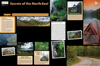
- 1. A few kilometres away from the monastery you will pass through a strait called Đavolje lazi in which the flow of the River Tara narrows to only 2-3 metres. Above on the sides of the canyon at an altitude of 950 m, is a black pine rainforest called Crna poda. Covering an area of 20 hectares, the pine trees reach a height of 45 m and an av- erage age of 400 years. There are recluses here too – trees which quietly, and seemingly without roots, hold onto their separate rocks reachable only by chamois. On leaving Đavolje Pode there is a resting place near a monument in honour of Dušan Bulatović– Džambas, where somebody is usually selling honey and other local specialities. The view from here extends to the valley that opens up towards Mojkovac. Beauty expressed in a thousand different ways. A beautiful and peaceful section of the road along Lake Plav, the Grbaje Valley and its crater, the summer pastures of Grbaja, Ali-Pasha’s Springs, the Grlja Falls, the Ropojana Valley... Slow down near the lake. For those who decide that the road is too narrow and winding for their vehicle, there is the possibility to turn left at the 160.4-km mark onto a new asphalt road, which leads to the other side of the lake through an interesting floodplain. The best place for those with campervans is near the Grlja Falls, and for camping in a tent Lakeviewers and the ethno-village of Komnenovo are the most comfortable places. It is good to take a break in Gusinje because of its local pies (burek). The Komovi These mountains open up as you descend towards Mateševo, from the ascent to Trešnjevik. Regard- less of any occasional traffic, if you want to take a photo or enjoy the view, pull over by a clear space on the road. On the Trešnjevik Ridge, on the right side from “Savova kafana”, a narrow asphalt road leads to the eco-summer-pasture of Štavna (4.2 km), in the vicinity of the peaks of the Komovi. The road is not suitable for the “M” and “L” camping ve- hicles, but for all others it is an undertaking worth both their time and effort. Down the Tara Canyon One of the most exciting descents in Montenegro starts after leaving Pljevlja, as it will lead us to the Tara Canyon, the deepest canyon in Europe (900- 1,300 m). The descent will lead us right onto a bridge most worthy of such a canyon: a thin string of beauty stretched above the turquoise of cold water turning to foam deep below. We will travel along half of the canyon, which is about eighty kilometres long, going up the “tear of Europe”. This canyon is part of Durmitor National Park (a UNESCO World Heritage Site). Right at the start of the bridge, to the left is a gravel road to the near- by camp called Kljajevića luka, a great place for a rest or for a rafting adventure down the River Tara. Aside from the roots of the black pine trees on the canyon’s boulders, there is also a legend about lumberjacks and rafters who ferried logs along the Tara. You will realise what they had to do once you feel the pulse of the raging river cur- rent, and when you trust your life to the guide and safety equipment on a rubber dinghy. The bridge is so narrow that it would be good for big campervans to wait for traffic coming from the opposite side to clear before crossing. There on the other side, you will see a crossroads which on one side leads towards Durmitor, but we will turn left from here, onto a road that leads through the can- yon towards Mojkovac. Paths full of adventure On the road towards Berane you should take a walk in Rožaje, a historically interesting town with monuments from the past. However, the real ad- venture for small camping vehicles can be found if you turn at the crossroads in Kalače, where the restaurant Venecija is located, down a narrow road (3.5 m), which leads towards Bijelo Polje. The road leads to a cultivated, open and idyllic region, throu- gh the light and shade of larch forests, the narrow, deserted and forgotten little canyon of the River Lješnica. 3 km from this canyon, by turning right, you can start another beautiful adventure: an as- cent (9-12%) up an attractive road, 2.5-3.5 m wide, to the village of Sušice and the edge of the Pešter Plateau. A thousand metres here is worth three thousand in any other “lazy” place. Then, return along the same road to take a rest in Bijelo Polje. Secrets of the North-East Looking for traces of the Orient, next to the tallest railway bridge in Europe and through the deepest canyon in Europe, in the bosom of the compressed Alps and on the doorstep of Mongolia. An exciting and irresistible adventure – beginning and ending in Podgorica. Detour – Lake Biograd A mountain lake of glacial origin, veiled in the romance of Mt. Bjelasica, beautiful at any time of day and all year round. Tucked away in an ancient forest, with a gentle murmur in tourist bungalows during the summer, the lake will probably captivate you longer than you planned. You will reach the lake along a track, when you turn left after the 5-km mark from the Bijelo Po- lje–Podgorica main road onto a road that slowly climbs towards the 4-km-distant Lake Biograd (1,094 metres above sea level). Đurđevi Stupovi (The Pillars of St. George) On the road towards Berane, there is the mona- stery of Đurđevi stupovi, part of the spiritual and monumental heritage of this region, and those who have time can explore the picturesque road that leads west, through the village of Lubnice towards Mt. Bjelasica. Dobrilovina Monastery Somewhere about half-way down the Tara Canyon (499 km), a road separates off towards the nearby beautiful Dobrilovina Monastery which is worth visiting. It was first mentioned at the end of the 16th century, when the Ottomans approved the restoration of the ruined church in Dobrilovina. The Railway Bridge at Mala Rijeka Did you start your journey in a rush and without a cup of coffee? Before the cross- roads at Bioče, 11 kilometres from the start, there is a restaurant with a terrace in the shade of a grapevine and with a view over the River Morača and over the nearby estuary of Mala Rijeka. Take a look at that slim water sinew which is strad- dled by a railway bridge, the second tall- est in Europe, 200 metres high and 500 metres long. Motorcyclescanreachthebridgebyamac- adam road, while it can also be reached by car if driving slowly and patiently. Podgorica - Lijeva Rijeka - Andrijevica - Plav - Gusinje - Plav - Berane - Rožaje - Trpezi - Bijelo Polje - Tomaševo - Pljevlja - Đurđevića Tara - Kolašin - Podgorica Length: 620 km The Hussein Pasha Mosque Do not miss the opportunity to see the Hussein Pasha’s mosque, built in the second half of the 16th century. The mo- squeisanexample of some of the best Balkan Oriental sacral archi- tecture, and its value is increased by the fact that it is preserved in almost its original form. Circle of wonders in Plav and Gusinje These restaurants and accommodation facilities are recommended by the author of the text.
- 2. 7 5 4 8 1 2 3 7 4 5 6 1 10 2 3 8 6 9 Morača Canyon - Platije The Morača Canyon is a rocky and green story, embellished by a statuesque medieval monu- ment – Morača Monastery (1252). Near the mon- astery, there is also a motel with a restaurant. As you continue driving, you will pass through the second part of the canyon, where the cruel and most attractive part called Platije is situated. The peaks rise up to 600 metres above the road, through an awe-inspiring area. Be careful when driving! Do not let the physique and conceit of the arched rocks seduce you, because the traffic is busy here and this is one of the most danger- ous roads in Montenegro. You will have an op- portunity for that before you leave the canyon, at a viewpoint 601 km from the start. Frequent restaurants near the road will notify you that Podgorica is very near and that an eventful and diverse trip is coming to an end. Secrets of the North-East Panoramic roads around MontEnEgro Food, Drinks and Souvenirs Montenegro is rich with sources of fresh, healthy water. To the taste of spring water add the supe- rior taste of the local cuisine. On the roads you will notice signs for paths of wine, cheese and honey, but besides these also do not miss the opportunity to buy food from the hosts. Also try their brandy, mead and of course – great wines. Authentic sou- venirs made from wool and wood will be not only memories, but also very useful items. Serbia Bosnia and Herzegovina Kosovo Albania Croatia In all towns in Montenegro there are local tourist organisation info centres where you can get additional information and explanations. Adriatic Se e Cultural Resources: 1. Hussein Pasha’s Mosque 2. Holy Trinity Monastery 3. St Peter’s Church 4. St Nicholas’ Church, Nikoljac 5. Đurđevi Stupovi Monastery 6. Redžepagića Tower 7. Morača Monastery 8. Dobrilovina Monastery Natural Resources: 1. Biogradska Gora National Park 2. Prokletije National Park 3. Durmitor National Park 4. Lovćen National Park 5. Lake Skadar National Park 6. Tara Canyon 7. Morača Canyon 8. Grlja Canyon 9. Ali Pasha's Springs 10. Dulovina Botanical Garden Just one part of the natural and cultural heritage of Montenegro along the panoramic roads. GPS www.panoramic.roads.montenegro.travel Panoramic Roads around Montenegro Publisher: Ministry of Sustainable Development and Tourism of Montenegro; The project team: Dušanka Pavićević, Anka Kujović, Branimir Raičević, Jovan Eraković, Kirsi Hyvaerinen, Dr. Thomas Wöhrstein, Milica Vušurović, Gojko Cimbaljević, Karsten Schöpfer; Author of the text: Jovan Eraković; Photographs: Jovan Eraković, Miodrag Bogdanović, Mobil Total, National Tourist Organisation (NTO) Archive; Translation: Porta Aperta; Reviewers: Sonja Živaljevć, Vesna Vukadinović; Design and Prepress: Ivanka Haverić; Printing by: Studio MOUSE; Copies: 1000 Types of vehicles Montenegrin attractive roads are of- ten very narrow, winding and with significant slopes. In order to specify the road conditions for different ve- hicles, we have defined the following categories: 1. Motorcycles (m) 2. Cars (c) 3. Small camping vehicles (S) Length up to 5.60 m Width up to 2.30 m Height up to 2.70 m 4. Medium-sized camping vehicles (M) Length up to 7.00 m Width up to 2.30 m Height up to 3.50 m 5. Large camping vehicles (L) Length 7.00 m and more Width 2.30 m and more Height 3.50 m and more Note: At this point the routes are not recommended for large camping vehicles (L) and drivers with no experience. Different seasons entail a variety of challenges. For more information and important information related to driving and routes, visit the site: www.panoramic.roads.montenegro.travel