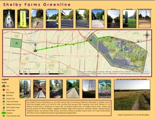
SFPCgreenlineA
- 1. Sources: Esri, HERE, DeLorme, USGS, Intermap, increment P Corp., NRCAN, Esri Japan, METI, Esri
China (Hong Kong), Esri (Thailand), TomTom, MapmyIndia, © OpenStreetMap contributors, and the GIS
User Community
Legend
Icons
Start
![ End
b Bike Rentals
Wolf River
Overton Park
!e Future Connections
!A Halfway Point (3.25 mi)
SFPC Visitor's Center
d Access Points
Greenline
^_ Future Greenline-East
S h e l b y F a r m s G r e e n l i n eS h e l b y F a r m s G r e e n l i n e
:
0 1 2 3 40.5
Miles
Entrance at Tillman Highland Street Graham Street Waring Road Podesta Street Wolf River End at Park Farm Road/ Park EntranceSign at Tillman
Park View From One of The Highest Points In Memphis
Overview