Jual Waterpas Leica NA300 Series

HUBUNGI KAMI: PT. Minds Indo Survey, Komp. Ruko Mega Kalimalang Kav.8 Jln. KH. Noer Ali No.11 Pekayon Jaya Bekasi 17148 Fax: 02188860790, Mobile: 082119953499, Email: budi1080@gmail.com, Kunjungi dan KLIK Web Kami: mindsindosurvey.co.id RUANG LINGKUP PENJUALAN, SERVICE / PERBAIKAN DAN PENYEWAAN ALAT-ALAT UKUR DAN PENGUKURAN TOPOGRAFI. PENJUALAN: • Alat Ukur - Total Station: (baru dan second hand) - Theodolite: (baru dan second hand) - Levels: (baru dan second hand) - GPS - USV - Bathymetric - Compass - Clinometer - Tandem/ Clino - Binocular - Digital Level - Digital Planimeter • Accessories: - Tripod - Prisma Polygon - Prisma Detail - Rambu Ukur - Meteran - Jalon - Tripod Jepit - Prisma mini PENYEWAAN: - Total Station - Theodolite - Automatic Level - GPS Geodetik - MEREK ALAT UKUR YANG TERSEDIA: - Minds - Spectra - Nikon - Suunto - Garmin - Topcon - Horizon - Sokkia - Leica - CHC - Trimble - CHCNAV SERVICE / PERBAIKAN DAN KALIBRASI MACAM-MACAM ALAT UKUR HARGA MENARIK / COMPETITIVE Catatan: Price List akan dikirim sesuai permintaan Contact Person Budianto 082119953499

Recommended
Recommended
More Related Content
More from Budi anto
More from Budi anto (20)
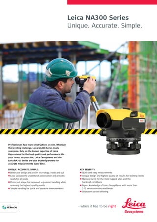
Jual Waterpas Leica NA300 Series
- 1. Leica NA300 Series Unique. Accurate. Simple. Professionals face many obstructions on site. Whatever the levelling challenge, Leica NA300 Series levels overcome. Rely on the known expertise of Leica Geosystems for the best quality and performance. On your terms, on your site, Leica Geosystems and the Leica NA300 Series are your trusted partners for accurate measurements every time. UNIQUE. ACCURATE. SIMPLE. n n Distinctive design and proven technology, inside and out n n Leica Geosystems understands construction and provides levels for all needs n n Protected shape for increased ergonomic handling while ensuring the highest quality results n n Simple handling for quick and accurate measurements KEY BENEFITS n n Quick and easy measurements n n Unique design and highest quality of results for levelling needs n n Manufactured for the most rugged sites and the harshest conditions n n Expert knowledge of Leica Geosystems with more than 270 service centres worldwide n n Unbeaten service offering
- 2. Leica Geosystems AG Heerbrugg, Switzerland www.leica-geosystems.com Digital Levels Construction Lasers Cable Locators Pipe Lasers Leica Geosystems offers a wide variety of construction instruments for your everyday use. Contact your local Leica Geosystems dealer for more information on our solutions. Illustrations, descriptions and technical data are not binding. All rights reserved. Printed in Switzerland – Copyright Leica Geosystems AG, Heerbrugg, Switzerland, 2016. 843989en – 01.16 – INT TECHNICAL DATA Standard deviation for 1 km double levelling (ISO17123-2) 2.5 mm 2.0 mm 1.8 mm TELESCOPE Telescope image Upright Magnification 20 x 24 x 32 x Objective aperture 36 mm Shortest target distance from instr. axis <1.0 m Field of view at 100 m <2.1 m Multiplication factor 100 Additive constant 0 COMPENSATOR Working range ± 15’ Setting accuracy (standard deviation) <0.5’’ Sensitivity 8’/2 mm HORIZONTAL CIRCLE Graduation 360° Graduation interval 1° Weight (net) 1.5 kg Operating temperature range –20° C to +40° C Leica NA320 Leica NA324 Leica NA332 Leica NA300 Series PROTECT is subject to Leica Geosystems’ international manufacturer warranty and the general terms and conditions for PROTECT. For more information visit www.leica-geosystems.com/protect