Jual CHCNAV P330 PRO UAV VTOL

HUBUNGI KAMI: PT. Minds Indo Survey, Komp. Ruko Mega Kalimalang Kav.8 Jln. KH. Noer Ali No.11 Pekayon Jaya Bekasi 17148 Fax: 02188860790, Mobile: 082119953499, Email: budi1080@gmail.com, Kunjungi dan KLIK Web Kami: mindsindosurvey.co.id RUANG LINGKUP PENJUALAN, SERVICE / PERBAIKAN DAN PENYEWAAN ALAT-ALAT UKUR DAN PENGUKURAN TOPOGRAFI. PENJUALAN: • Alat Ukur - Total Station: (baru dan second hand) - Theodolite: (baru dan second hand) - Levels: (baru dan second hand) - GPS - USV - Bathymetric - Compass - Clinometer - Tandem/ Clino - Binocular - Digital Level - Digital Planimeter • Accessories: - Tripod - Prisma Polygon - Prisma Detail - Rambu Ukur - Meteran - Jalon - Tripod Jepit - Prisma mini PENYEWAAN: - Total Station - Theodolite - Automatic Level - GPS Geodetik - MEREK ALAT UKUR YANG TERSEDIA: - Minds - Spectra - Nikon - Suunto - Garmin - Topcon - Horizon - Sokkia - Leica - CHC - Trimble - CHCNAV SERVICE / PERBAIKAN DAN KALIBRASI MACAM-MACAM ALAT UKUR HARGA MENARIK / COMPETITIVE Catatan: Price List akan dikirim sesuai permintaan Contact Person Budianto 082119953499

Recommended
Recommended
More Related Content
More from Budi anto
More from Budi anto (20)
Jual CHCNAV P330 PRO UAV VTOL
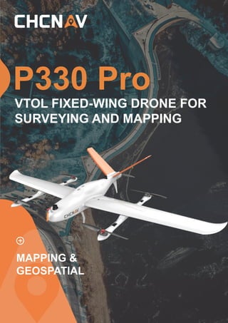
- 1. P330 Pro MAPPING & GEOSPATIAL VTOL FIXED-WING DRONE FOR SURVEYING AND MAPPING
- 2. UNMANNED LONG FIXED-WING DRONE ENDURANCE VTOL CHCNAV · P330 Pro The P330 Pro is a high-performance vertical takeoff and landing (VTOL) fixed-wing unmanned aircraft system (UAS), specially designed for aerial surveying and mapping applications. With its concept of high accuracy, long endurance and multiple payloads, it meets the requirements of mapping and aerial surveying professionals for many different applications. The P330 Pro features a 100 Hz differential module, which allows aerial mapping operations at the centimeter level, and a flight endurance with payload reaching more than 150 minutes. The VTOL P330 Pro UAV allows you to conduct small- and large-scale aerial surveys with extreme data quality and at significant time and cost savings. The CHCNAV P330 Pro is an alternative to manned aircraft for surveying and mapping, mining, construction and infrastructure, environmental monitoring, agriculture, etc. HIGH EFFICIENCY, LONG ENDURANCE AERIAL MAPPING. ANYWHERE 150 mins endurance and up to 20 km² coverage per flight Vertical takeoff and landing with adjustable tail paddle The P330 Pro VTOL drone is characterized by an ultra-efficient aerodynamic design and can reach 150 minutes endurance with its payload to cover large areas per flight. With a wingspan of only 2.5 m and a fuselage of only 1.15 m, its advanced power management and superior navigation algorithms, the P330 Pro can accurately map a region of 20 km² at a scale of 1:2000. Mapping highway corridors and surveying open-pit mines are now within reach in a single flight. CAPTURE HIGHER ACCURACY DATA High-resolution camera and high-accuracy GNSS PPK/RTK module SWAPPABLE AIRBORNE SENSORS FOR ALL APPLICATIONS Switching cameras in the field is fast and simple The P330Pro is not only available with an orthophoto camera for producing orthophoto maps, but also with optional sensors, such as a oblique camera for a 3D modeling applications, to address the most demanding mapping and topographic surveys. The new load bay design supports a wide range of sensors, including orthophoto cameras, half-frame and full-frame oblique cameras, medium-frame cameras,multispectral cameras, or lightweight laser scanners, and the ability to quickly switch between them. REDUCE OPERATING COSTS AND SAVE TIME TRUSTED BY AERIAL SURVEY SPECIALISTS No more systematic Ground Control Points (GCP) required Triple redundant flight control system and safer operation The P330Pro is equipped with a high-accuracy GNSS RTK / PPK module with up to 100 Hz differential data update rate. With its advanced GNSS PPK data processing and photogrammetry software, the final mapping results are accurate to the centimeter level. Avoiding the establishment of ground control points can also save up to half of the time required for the project. Faster data acquisition with a smaller field crew significantly increases the return on investment of the mission. The P330 Pro is packed with the latest aviation technologies. A dual GNSS system, a triple IMU system, dual antenna positioning and orientation, 5 safe return to base strategies, and 9 safety monitoring checks guarantee safe flight operations and reliable aerial survey results. The P330Pro supports various high-resolution cameras to guarantee a high ground sampling distance (GSD) and undistorted images. Survey- grade aerial data are obtained with the built-in high-accuracy GNSS module, providing absolute horizontal accuracy of up to 1 cm/pixel. The P330Pro is a vertical takeoff and landing fixed-wing drone. With its VTOL concept and high accuracy GNSS positioning system, it ensures take-off and landing in a smaller area. With the use of dedicated propeller blades, it can be operated at altitudes of up to 6,000 m, extending its operational range to high altitude survey areas. The P330 Pro can be assembled and disassembled in minutes and allows for easy portability to the mission site in its carrying case.
- 3. CHCNAV · P330 Pro AIRBORNE SURVEYING CHCNAV CGO2 processes the POS data of the drone with base station to get a higher precision POS. High Precision POS Easier for management, transportation and storage. Smart Battery Swappable payload, easy to switch, meets the request of different applications. Multiple Payloads EasyFly ground control software makes mission planning and pre- flight checks easier and safer. User Friendly Software
- 4. 3 @ CHC Navigation Headquarter Shanghai Huace Navigation Technology Ltd. 599 Gaojing Road, Building D, Shanghai, 201702, China +86 21 54260273 CHC Navigation Europe Infopark Building , Sétány 1, 1117 Budapest, Hungary +36 20 235 8248 +36 20 5999 369 info@chcnav.eu CHC Navigation USA LLC 16412 N 92nd Street, Suite 115, 85 260 Scottsdale, Arizona, USA +1 480 676 4306 CHC Navigation India 409 Trade Center, Khokhra Circle, Maninagar East, Ahmedabad, Gujarat, India +91 90 99 98 08 02 WWW.CHCNAV.COM | SALES@CHCNAV.COM SPECIFICATIONS *All specifications are subject to change without notice. (1) Under optimal condition, ≈1000 hPa pressure, no wind or breeze, +10°C ~ +25°C. (2) Accuracy and reliability are determined under open sky, free of multipaths, optimal GNSS geometry and atmospheric condition. (3) With plateau tail paddle. (4) Under optimal condition, open area, no obstacle between the base and drone. (5) Depends on project requirement, please refer to the white paper of the performance without GCPs. © 2021 Shanghai Huace Navigation Technology Ltd. All rights reserved. The CHC and CHC logo are trademarks of Shanghai Huace Navigation Technology Limited. All other trademarks are the property of their respective owners. Revision April 2021. Vertical take-off and landing (VTOL) Battery Type Li-Po (12S) -20°C ~ + 50°C Operating Temperature -10°C ~ +65°C Charing Time < 100 mins 1250 mm x 450 mm x 450 mm Weight 5.7 kg Up to 12 m/s 4 + 1 2 kg 14 kg 160 mins (without payload) 21 m/s 5 m/s 2.8 m/s 2.53 m 1.21 m 50 ~ 200 m H: 1 cm + 1 ppm V: 2 cm + 1 ppm Support 5 mins 6000 m Up to 15 km Drone Type Electric Motors Max. Payload Max. Take-off Weight Max. Flight Time (1) Cruise Speed Max. Climbing Speed Max. Descent Speed Wingspan Fuselage Length Vertical Take-off Height RTK Accuracy (2) $'6% AreaSetup Time Max. Flight Altitude (MSL) (3) Transmission Distance (4) Operating Termperature Wind ResistanceTransport Case Dimension GCPs (5) Not required with PPK Capacity 27,000 mAh Size 240 mm x 135 mm x 100 mm Drone Battery PAYLOADS Number of CMOS 1 Number of CMOS 5 Pixel 210 MP (in total) Storage 640 GB /1280 GB Weight 960 g Sensor Size Full frame (35.9 x 24 mm) Exposure Interval ≤ 0.6 s Power Supply 5 APS-C, 23.5 x 15.6 mm 130 MP (in total) ≤ 0.6 s 640 GB Powered by drone 660 g Powered by drone Pixel 61 MP Operating Temperature 0°C ~ +40°C Sensor size Full frame (35.9 x 24 mm) Storage 64 GB Power Supply Independent or flight control power supply Weight 1 Full frame (35.9 x 24 mm) 42 MP 128 GB 0°C ~ +40°C Powered by drone 330 g 1 Full frame (35.9 x 24 mm) 61MP 128 GB 0°C ~ +40°C Powered by drone 330 g 580 g (Host only) M4 HC16 α7RIV C30 DG4 Pro D2 5 APS-C, 23.5 x 15.6 mm 120 MP (in total) ≤ 0.8 s 640 GB Powered by drone 960g