1. Arc gis sample work
Brunswick Georgia Suitable development areas not in flood zone Classification AE….Pg. 1
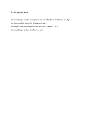
San Diego suitability analysis for development….pg. 2
Philadelphia watershed delineation from processed LIDAR data….pg. 3
Brunswick Georgia land use classification….pg. 4
2. Value
High : 10
Low : 0
Value
High : 6
Low : 0
1 in = 1 miles
1 in = 1 miles
q
qAE Zone
1 in = 1 milesq
DifferentsuitabilityindexvaluesandResults
3. 0 10 20 30 405
Miles
FuzzyOverand
<VALUE>
0 - 0.005
0.005 - 0.024
0.024 - 0.074
0.074 - 0.1
0.1 - 0.2
0.2 - 0.25
Urban
San_Diego
Map by: Alex Smith
Appropriate areas
for Development
Map Created by using Fuzzy Overlay
analysis o fCurrent Urban
areas, Highways, Parks, and elevation.
Fuzzy overlay
Workflow
³