Beginners Guide to TikTok for Search - Rachel Pearson - We are Tilt __ Bright...
Topographic maps task
1. Name : Marta Asri Dewi
Student Number : 12315244009
Class/Semester : International Science Education/3
Course :Practical of Earth Science
Using Topographic Maps
Topographic maps represent the locations by using a special type of line, called a
contour line, to show elevation change on the earth surface. Below is an example of
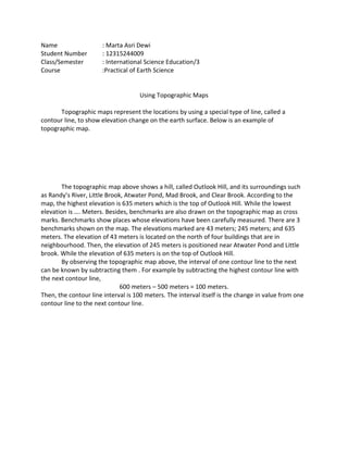
topographic map.
The topographic map above shows a hill, called Outlook Hill, and its surroundings such
as Randy’s River, Little Brook, Atwater Pond, Mad Brook, and Clear Brook. According to the
map, the highest elevation is 635 meters which is the top of Outlook Hill. While the lowest
elevation is …. Meters. Besides, benchmarks are also drawn on the topographic map as cross
marks. Benchmarks show places whose elevations have been carefully measured. There are 3
benchmarks shown on the map. The elevations marked are 43 meters; 245 meters; and 635
meters. The elevation of 43 meters is located on the north of four buildings that are in
neighbourhood. Then, the elevation of 245 meters is positioned near Atwater Pond and Little
brook. While the elevation of 635 meters is on the top of Outlook Hill.
By observing the topographic map above, the interval of one contour line to the next
can be known by subtracting them . For example by subtracting the highest contour line with
the next contour line,
600 meters – 500 meters = 100 meters.
Then, the contour line interval is 100 meters. The interval itself is the change in value from one
contour line to the next contour line.