
Recommended
More Related Content
Viewers also liked
Viewers also liked (10)
More from GeographyByTian
More from GeographyByTian (12)
Recently uploaded
Recently uploaded (20)
Notes - Chapter 5 Floods (Part 2)
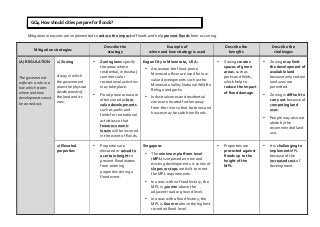
- 1. Mitigation measures are implemented to reduce the impact of floods and help prevent floods from occurring. Mitigation strategies Describe the strategy Example of where and how strategy is used Describe the benefits Describe the challenges (A) REGULATION The government enforces a rule or a law which states where and how developments must be carried out. 1) Zoning A way in which the government plans the physical development of the land and its uses. • Zoning laws specify the areas where residential, industrial, commercial or recreational activities may take place. • Flood-‐prone areas are often zoned as low-‐ value developments such as parks and fields for recreational activities so that fewer economic losses will be incurred in the event of floods. Eagan City in Minnesota, USA: • Areas near the flood-‐prone Minnesota River are used for low-‐ value developments such as the Minnesota Valley National Wildlife Refuge and parks. • Industrial zones and residential zones are located further away from the river so that factories and houses may be safe from floods. • Zoning creates spaces of green areas, such as parks and fields, which help to reduce the impact of flood damage. • Zoning may limit the development of available land because only certain land uses are permitted. • Zoning is difficult to carry out because of competing land uses. • People may also not abide by the recommended land use. 2) Elevated properties • Properties are elevated or raised to a certain height to prevent floodwaters from entering properties during a flood event. Singapore: • The minimum platform level (MPL) is imposed on new and existing developments. A series of slopes or steps are built to meet the MPL requirements. • In areas with no flood history, the MPL is 300 mm above the adjacent road or ground level. • In areas with a flood history, the MPL is 600 mm above the highest recorded flood level. • Properties are protected against floods up to the height of the MPL. • It is challenging to implement MPL because of the increased cost of development. GQ4 How should cities prepare for floods?
- 2. Mitigation strategies Describe the strategy Example of where and how strategy is used Describe the benefits Describe the challenges (B) INVESTMENT IN INFRASTRUCTURE To build new flood barriers; to maintain existing flood prevention structures to ensure they are in working condition. 3) Levees and floodwalls • Levees are raised banks which can be natural (made of mud) or man-‐made (made of concrete). • Floodwalls are man-‐made structures that are made of concrete. • Both levees and floodwalls are barriers that are built higher than floodplains and rivers so that they can help keep out floodwater or prevent flooding. Sacramento, USA: • In the 1870s, several kilometres of levees have been built along the Sacramento River to protect the surrounding land from floods. Hereford in Herefordshire, UK: • In 2008, a floodwall was built along River Wye to protect the city from flooding during heavy rains. • It is cheaper to build levees and floodwalls as compared to raising the height of the land surrounding the river. • Regular maintenance is required to ensure that the levees and floodwalls are strong enough to hold back floodwater. • Levees and floodwalls are only designed to hold back water up to a certain level. However, they are unable to prevent floods beyond that level. 4) Channel improvement • River channels and canals can be widened and deepened to increase its capacity to hold water and carry more storm water away. • They can also be straightened so that water can be carried away quickly. • This would prevent the water in river channels or canals from overflowing and flooding the surrounding areas. Singapore: • A section of the Bukit Timah Canal was widened and deepened to increase the channel capacity. • Channel improvement makes it possible for moderate-‐ value and high-‐ value developments to take place on the land next to river channels or canals. • Is difficult to carry out when the land next to the river channels and canals is already used for other purposes. • Channel improvement may create problems for areas upstream or downstream of the improved area.
- 3. Mitigation strategies Describe the strategy Example of where and how strategy is used Describe the benefits Describe the challenges (C) DISASTER PREPAREDNESS 5) Forecasting and warning system To warn people of possible floods. • Water levels in river channels and canals, tide levels in seas and surrounding weather conditions are monitored regularly using manual monitoring systems and technology (eg. remote sensing techniques & geographical information systems). • The information collected is then analysed to make a flood forecast on the areas that are likely to be flooded. • Subsequently, flood warnings are issued to the public via social media, television and radio so that people can take necessary precautions in advance. Singapore: • Water level sensors are placed in canals and drains to gather data about the changing water levels at regular intervals. • Weather instruments are used to monitor the tides and weather conditions on a daily basis. • A forecasting and warning system provides useful information so that there is time for people to take action to minimise flood damage. • Some cities may not have the expertise and technology to collect accurate data and make accurate flood forecasts. 6) Evacuation drills To train people to know what to do when a flood occurs. • A form of preparedness measure where people practise the steps to leave a place in a safe and orderly manner during an emergency. • It involves people moving to safe locations by following instructions given by trained personnel and practising first aid. Singapore: • PUB has provided a public advisory on what pedestrians, motorists, residents and business owners can do in the event of a flash flood. • People are educated on what to do when a flood warning is issued and this would thus reduce panic during a flood event. • Limited participation from the public will reduce the effectiveness of the city’s evacuation plan.