SlideShare a Scribd company logo
1 of 1
Download to read offline
FRIDAY, OCTOBER 25, 2019
Developing the Story Behind the Data
Written by Bill Bass, GISP, Geospatial & Analytics Senior Manager
HARC’s team of geospatial and analytics researchers spend significant time developing and analyzing data to
unlock value and communicate information to a diverse audience. Whether the resulting products are written
reports, report cards, data dashboards, analytical tools or narratives called Story Maps, there is something for
everyone interested in the research conducted by HARC.
HARC leverages a suite of geospatial and analytical tools from industry leaders such as ESRI, SAS, Tableau, and
Microsoft. The software and services from each of these companies provide strong capabilities as individual
systems, but when integrated to provide geospatial data development and analytical workflows, a value greater
than the sum of its parts is realized. Analyses require access to high quality data, and HARC leverages a variety
of authoritative datasets collected from private and non-profit sectors, as well as federal, state, and regional
agencies. Many of these data are publicly funded at a fraction of the cost compared to obtaining data from
private sources, and is in turn, delivered at little cost to the public. The public funding of data development
allows research organizations like HARC to focus resources on data analysis and the creation of usable
information products.
One example of how HARC integrates multiple data systems is in the development of HARC's Land Cover
Change story map. Within this interactive application, viewers can obtain information by watershed on
regional changes to impervious cover, developed lands, forests, wetlands, and other types of land cover. Data in
the story map were produced using an integrated workflow across multiple software platforms, leveraging each
for its strengths to produce the final product. The result is a guided narrative on changes to regional land cover
that also delivers access to statistical information for those wanting to explore data in greater detail.
HARC’sHARC’s Houston-Galveston & Southeast Texas Land Cover Story MapHouston-Galveston & Southeast Texas Land Cover Story Map
Conducting analyses as described above would not be possible without access to large scale federal and state
datasets like the National Oceanic and Atmospheric Administration’s Coastal Change and Analysis Program
NOAA’s C-CAP Land Cover land cover or the Texas Commission on Environmental Quality’s Surface Water
Quality Monitoring Information System or the TCEQ SWQMIS water quality databases. Understanding our
natural environment, environmental risks, and changes to our ecosystems are near impossible without access to
these databases; and without these programs, collection would be cost prohibitive and rely upon private
funding. These programs provide a vast wealth of information that academic, nonprofit, and private sector
entities can leverage in understanding a changing world. Another example is Light Detection and Ranging
(LiDAR) data, a remote sensing, data collection technology that has traditionally been used in determining
ground elevations. HARC has recently been working on models and workflows to extract other important data
from this dataset, such as land cover classification and tree canopy coverage. Innovative programs and processes
such as these will help to produce new information products that can be leveraged in a variety of ways beyond
their initial use cases. Ultimately, access to these data and the development of new information products allows
for a consistent and standardized framework upon which partners can leverage resources and expertise,
provides better inputs to decision making processes, and creates stronger opportunities for public education
and community outreach and engagement.
At HARC, collecting data is just the beginning. The real value is created when data are combined with new
information from other sources to find relationships not previously known. HARC’s extensive geospatial
systems architecture provides a platform upon which research teams can develop innovative and engaging
information products. No longer does a system need to be installed and configured to meet the needs of a single
project, which takes time and resources from the core focus of the research project. HARC’s integrated
geospatial capabilities allows our researchers to develop, analyze, and share information in a visually compelling
way through maps, graphs, and visualizations using a platform that can be leveraged in an on-going manner.
This enables a reduced time to market for research projects and allows researchers to focus on the analysis and
content aspects of the project.
When a natural disaster strikes, there is often a gap in information describing environmental impacts. In
August 2017 Hurricane Harvey, a devastating hurricane and flood event, struck the Upper Texas Coast. Media
reports of Harvey’s impact on the Houston-Galveston region in terms of damage to life, property and
communities were immediate. However, information on environmental impacts was less evident. A number of
organizations actively collected hydrologic, air quality, and water quality data throughout the region while the
natural disaster unfolded. The stories of what those data represented needed to be told in a manner that could
quickly reach a broad audience. Using HARC’s geospatial and analytics platform, researchers were able to collect
data, process it, and develop the interactive Summarizing Hurricane Harvey’s Environmental Impacts, story
map, helping individual users and other organizations in the region access and understand information and take
needed action.
HARC's Summarizing Hurricane Harvey's Environmental ImpactsHARC's Summarizing Hurricane Harvey's Environmental Impacts Story MapStory Map
HARC's geospatial and analytics capabilities allow for a higher degree of interactivity with project stakeholders
and business partners. In a recent research project, HARC business partners and project stakeholders accessed
web-based maps that allowed them to see the analysis products being generated by HARC during development.
This type of interaction facilitated an iterative feedback loop between business partners, stakeholders, and the
HARC research team, thereby allowing the project to adjust end products as project needs evolved. Throughout
the process, and through various adjustments, HARC produced a final product that exceeded the needs of
stakeholders and partners.
To view HARC’s geospatial products and learn more about our capabilities, visit GIS.HARCresearch.org, or e-
mail us at HARCGIS@HARCresearch.org.
Bill Bass, GISP
Geospatial & AnalyticsGeospatial & Analytics
Senior ManagerSenior Manager
Bill Bass is a Certified GIS
professional and has extensive
experience in geospatial
technologies, project
management, and enterprise
solutions.
TELLING THE DATA STORY
HARC's Geospatial and Analytics team utilize data to share information in a compelling way.
OUR BLOGOUR BLOG

More Related Content

What's hot

Open data presentation 2014 v1.3 - Nov 2014
Open data presentation 2014 v1.3 - Nov 2014Open data presentation 2014 v1.3 - Nov 2014
Open data presentation 2014 v1.3 - Nov 2014Pia Waugh
 
Meta Data and Quality of Data for OGD Platform India
Meta Data and Quality of Data for OGD Platform IndiaMeta Data and Quality of Data for OGD Platform India
Meta Data and Quality of Data for OGD Platform IndiaData Portal India
 
Data behind figures in AAS journals
Data behind figures in AAS journalsData behind figures in AAS journals
Data behind figures in AAS journalsChris Biemesderfer
 
A Case Study of Two Health Insurance Marketplaces: Leveraging Interactive Map...
A Case Study of Two Health Insurance Marketplaces: Leveraging Interactive Map...A Case Study of Two Health Insurance Marketplaces: Leveraging Interactive Map...
A Case Study of Two Health Insurance Marketplaces: Leveraging Interactive Map...soder145
 

What's hot (7)

Open data presentation 2014 v1.3 - Nov 2014
Open data presentation 2014 v1.3 - Nov 2014Open data presentation 2014 v1.3 - Nov 2014
Open data presentation 2014 v1.3 - Nov 2014
 
SMART Emergency Medical Teams
SMART Emergency Medical TeamsSMART Emergency Medical Teams
SMART Emergency Medical Teams
 
Meta Data and Quality of Data for OGD Platform India
Meta Data and Quality of Data for OGD Platform IndiaMeta Data and Quality of Data for OGD Platform India
Meta Data and Quality of Data for OGD Platform India
 
Data behind figures in AAS journals
Data behind figures in AAS journalsData behind figures in AAS journals
Data behind figures in AAS journals
 
PII_IQPC_May_04
PII_IQPC_May_04PII_IQPC_May_04
PII_IQPC_May_04
 
Introduction to OpenDataCommunities | Linda O'Halloran
Introduction to OpenDataCommunities | Linda O'HalloranIntroduction to OpenDataCommunities | Linda O'Halloran
Introduction to OpenDataCommunities | Linda O'Halloran
 
A Case Study of Two Health Insurance Marketplaces: Leveraging Interactive Map...
A Case Study of Two Health Insurance Marketplaces: Leveraging Interactive Map...A Case Study of Two Health Insurance Marketplaces: Leveraging Interactive Map...
A Case Study of Two Health Insurance Marketplaces: Leveraging Interactive Map...
 

Similar to Developing the Story Behind the Data

Not the Geography You Remember
Not the Geography You RememberNot the Geography You Remember
Not the Geography You RememberBill Bass
 
IT Project Consultant
IT Project ConsultantIT Project Consultant
IT Project ConsultantDashiell Cruz
 
The power of maps
The power of mapsThe power of maps
The power of mapsIRC
 
NOAA Big Data Project Handout
NOAA Big Data Project HandoutNOAA Big Data Project Handout
NOAA Big Data Project HandoutAmy Gaskins
 
Climate Change & Africa
Climate Change & AfricaClimate Change & Africa
Climate Change & AfricaEsri
 
Wide access to spatial Citizen Science data - ECSA Berlin 2016
Wide access to spatial Citizen Science data - ECSA Berlin 2016Wide access to spatial Citizen Science data - ECSA Berlin 2016
Wide access to spatial Citizen Science data - ECSA Berlin 2016COBWEB Project
 
3 Round Stones Briefing to U.S. EPA's Chief Data Scientist on Open Data
3 Round Stones Briefing to U.S. EPA's Chief Data Scientist on Open Data3 Round Stones Briefing to U.S. EPA's Chief Data Scientist on Open Data
3 Round Stones Briefing to U.S. EPA's Chief Data Scientist on Open DataBernadette Hyland-Wood
 
Brief on Linked Data at U.S. EPA to Chief Data Scientist
Brief on Linked Data at U.S. EPA to Chief Data ScientistBrief on Linked Data at U.S. EPA to Chief Data Scientist
Brief on Linked Data at U.S. EPA to Chief Data ScientistBernadette Hyland-Wood
 
Brief on Linked Data for U.S. EPA's Chief Data Scientist
Brief on Linked Data for U.S. EPA's Chief Data ScientistBrief on Linked Data for U.S. EPA's Chief Data Scientist
Brief on Linked Data for U.S. EPA's Chief Data Scientist3 Round Stones
 
FGP Open Group Paris 2016 Presentation FINAL - EN
FGP Open Group Paris 2016 Presentation FINAL - ENFGP Open Group Paris 2016 Presentation FINAL - EN
FGP Open Group Paris 2016 Presentation FINAL - ENBilyana Anicic
 
Proposal for Designing a Linked Data Migrational Framework for Singapore Gove...
Proposal for Designing a Linked Data Migrational Framework for Singapore Gove...Proposal for Designing a Linked Data Migrational Framework for Singapore Gove...
Proposal for Designing a Linked Data Migrational Framework for Singapore Gove...Aravind Sesagiri Raamkumar
 
D2.1 EnviroGRIDS interoperability guideline
D2.1 EnviroGRIDS interoperability guidelineD2.1 EnviroGRIDS interoperability guideline
D2.1 EnviroGRIDS interoperability guidelineenvirogrids-blacksee
 
Experiences as a producer, consumer and observer of open data
Experiences as a producer, consumer and observer of open dataExperiences as a producer, consumer and observer of open data
Experiences as a producer, consumer and observer of open dataProgCity
 
Towards High-Value Datasets determination for data-driven development: a syst...
Towards High-Value Datasets determination for data-driven development: a syst...Towards High-Value Datasets determination for data-driven development: a syst...
Towards High-Value Datasets determination for data-driven development: a syst...Anastasija Nikiforova
 

Similar to Developing the Story Behind the Data (20)

Not the Geography You Remember
Not the Geography You RememberNot the Geography You Remember
Not the Geography You Remember
 
IT Project Consultant
IT Project ConsultantIT Project Consultant
IT Project Consultant
 
The power of maps
The power of mapsThe power of maps
The power of maps
 
NOAA Big Data Project Handout
NOAA Big Data Project HandoutNOAA Big Data Project Handout
NOAA Big Data Project Handout
 
Climate Change & Africa
Climate Change & AfricaClimate Change & Africa
Climate Change & Africa
 
Groundwater Data Delivery & Visualization
Groundwater Data Delivery & VisualizationGroundwater Data Delivery & Visualization
Groundwater Data Delivery & Visualization
 
Wide access to spatial Citizen Science data - ECSA Berlin 2016
Wide access to spatial Citizen Science data - ECSA Berlin 2016Wide access to spatial Citizen Science data - ECSA Berlin 2016
Wide access to spatial Citizen Science data - ECSA Berlin 2016
 
Ariadne: Extended CRM
Ariadne: Extended CRMAriadne: Extended CRM
Ariadne: Extended CRM
 
Fastnet Awma Em
Fastnet Awma EmFastnet Awma Em
Fastnet Awma Em
 
3 Round Stones Briefing to U.S. EPA's Chief Data Scientist on Open Data
3 Round Stones Briefing to U.S. EPA's Chief Data Scientist on Open Data3 Round Stones Briefing to U.S. EPA's Chief Data Scientist on Open Data
3 Round Stones Briefing to U.S. EPA's Chief Data Scientist on Open Data
 
Brief on Linked Data at U.S. EPA to Chief Data Scientist
Brief on Linked Data at U.S. EPA to Chief Data ScientistBrief on Linked Data at U.S. EPA to Chief Data Scientist
Brief on Linked Data at U.S. EPA to Chief Data Scientist
 
Brief on Linked Data for U.S. EPA's Chief Data Scientist
Brief on Linked Data for U.S. EPA's Chief Data ScientistBrief on Linked Data for U.S. EPA's Chief Data Scientist
Brief on Linked Data for U.S. EPA's Chief Data Scientist
 
FGP Open Group Paris 2016 Presentation FINAL - EN
FGP Open Group Paris 2016 Presentation FINAL - ENFGP Open Group Paris 2016 Presentation FINAL - EN
FGP Open Group Paris 2016 Presentation FINAL - EN
 
Proposal for Designing a Linked Data Migrational Framework for Singapore Gove...
Proposal for Designing a Linked Data Migrational Framework for Singapore Gove...Proposal for Designing a Linked Data Migrational Framework for Singapore Gove...
Proposal for Designing a Linked Data Migrational Framework for Singapore Gove...
 
D2.1 EnviroGRIDS interoperability guideline
D2.1 EnviroGRIDS interoperability guidelineD2.1 EnviroGRIDS interoperability guideline
D2.1 EnviroGRIDS interoperability guideline
 
Experiences as a producer, consumer and observer of open data
Experiences as a producer, consumer and observer of open dataExperiences as a producer, consumer and observer of open data
Experiences as a producer, consumer and observer of open data
 
Towards High-Value Datasets determination for data-driven development: a syst...
Towards High-Value Datasets determination for data-driven development: a syst...Towards High-Value Datasets determination for data-driven development: a syst...
Towards High-Value Datasets determination for data-driven development: a syst...
 
Gis
GisGis
Gis
 
Washington
WashingtonWashington
Washington
 
Wa final
Wa finalWa final
Wa final
 

More from Bill Bass

Not Business As Usual
Not Business As UsualNot Business As Usual
Not Business As UsualBill Bass
 
Houston-Galveston and Southeast Texas Land Cover Change
Houston-Galveston and Southeast Texas Land Cover ChangeHouston-Galveston and Southeast Texas Land Cover Change
Houston-Galveston and Southeast Texas Land Cover ChangeBill Bass
 
Integrated Geospatial Platform For Regional Planning
Integrated Geospatial Platform For Regional PlanningIntegrated Geospatial Platform For Regional Planning
Integrated Geospatial Platform For Regional PlanningBill Bass
 
Eco-Logical GIS
Eco-Logical GISEco-Logical GIS
Eco-Logical GISBill Bass
 
Assessment of Risk Perception Based Upon Prior Flood Occurrences in the Regio...
Assessment of Risk Perception Based Upon Prior Flood Occurrences in the Regio...Assessment of Risk Perception Based Upon Prior Flood Occurrences in the Regio...
Assessment of Risk Perception Based Upon Prior Flood Occurrences in the Regio...Bill Bass
 
Natural Hazards and Regional Planning
Natural Hazards and Regional PlanningNatural Hazards and Regional Planning
Natural Hazards and Regional PlanningBill Bass
 

More from Bill Bass (6)

Not Business As Usual
Not Business As UsualNot Business As Usual
Not Business As Usual
 
Houston-Galveston and Southeast Texas Land Cover Change
Houston-Galveston and Southeast Texas Land Cover ChangeHouston-Galveston and Southeast Texas Land Cover Change
Houston-Galveston and Southeast Texas Land Cover Change
 
Integrated Geospatial Platform For Regional Planning
Integrated Geospatial Platform For Regional PlanningIntegrated Geospatial Platform For Regional Planning
Integrated Geospatial Platform For Regional Planning
 
Eco-Logical GIS
Eco-Logical GISEco-Logical GIS
Eco-Logical GIS
 
Assessment of Risk Perception Based Upon Prior Flood Occurrences in the Regio...
Assessment of Risk Perception Based Upon Prior Flood Occurrences in the Regio...Assessment of Risk Perception Based Upon Prior Flood Occurrences in the Regio...
Assessment of Risk Perception Based Upon Prior Flood Occurrences in the Regio...
 
Natural Hazards and Regional Planning
Natural Hazards and Regional PlanningNatural Hazards and Regional Planning
Natural Hazards and Regional Planning
 

Recently uploaded

Customer Service Analytics - Make Sense of All Your Data.pptx
Customer Service Analytics - Make Sense of All Your Data.pptxCustomer Service Analytics - Make Sense of All Your Data.pptx
Customer Service Analytics - Make Sense of All Your Data.pptxEmmanuel Dauda
 
100-Concepts-of-AI by Anupama Kate .pptx
100-Concepts-of-AI by Anupama Kate .pptx100-Concepts-of-AI by Anupama Kate .pptx
100-Concepts-of-AI by Anupama Kate .pptxAnupama Kate
 
Dubai Call Girls Wifey O52&786472 Call Girls Dubai
Dubai Call Girls Wifey O52&786472 Call Girls DubaiDubai Call Girls Wifey O52&786472 Call Girls Dubai
Dubai Call Girls Wifey O52&786472 Call Girls Dubaihf8803863
 
dokumen.tips_chapter-4-transient-heat-conduction-mehmet-kanoglu.ppt
dokumen.tips_chapter-4-transient-heat-conduction-mehmet-kanoglu.pptdokumen.tips_chapter-4-transient-heat-conduction-mehmet-kanoglu.ppt
dokumen.tips_chapter-4-transient-heat-conduction-mehmet-kanoglu.pptSonatrach
 
Kantar AI Summit- Under Embargo till Wednesday, 24th April 2024, 4 PM, IST.pdf
Kantar AI Summit- Under Embargo till Wednesday, 24th April 2024, 4 PM, IST.pdfKantar AI Summit- Under Embargo till Wednesday, 24th April 2024, 4 PM, IST.pdf
Kantar AI Summit- Under Embargo till Wednesday, 24th April 2024, 4 PM, IST.pdfSocial Samosa
 
Delhi Call Girls Punjabi Bagh 9711199171 ☎✔👌✔ Whatsapp Hard And Sexy Vip Call
Delhi Call Girls Punjabi Bagh 9711199171 ☎✔👌✔ Whatsapp Hard And Sexy Vip CallDelhi Call Girls Punjabi Bagh 9711199171 ☎✔👌✔ Whatsapp Hard And Sexy Vip Call
Delhi Call Girls Punjabi Bagh 9711199171 ☎✔👌✔ Whatsapp Hard And Sexy Vip Callshivangimorya083
 
Beautiful Sapna Vip Call Girls Hauz Khas 9711199012 Call /Whatsapps
Beautiful Sapna Vip  Call Girls Hauz Khas 9711199012 Call /WhatsappsBeautiful Sapna Vip  Call Girls Hauz Khas 9711199012 Call /Whatsapps
Beautiful Sapna Vip Call Girls Hauz Khas 9711199012 Call /Whatsappssapnasaifi408
 
B2 Creative Industry Response Evaluation.docx
B2 Creative Industry Response Evaluation.docxB2 Creative Industry Response Evaluation.docx
B2 Creative Industry Response Evaluation.docxStephen266013
 
VIP High Profile Call Girls Amravati Aarushi 8250192130 Independent Escort Se...
VIP High Profile Call Girls Amravati Aarushi 8250192130 Independent Escort Se...VIP High Profile Call Girls Amravati Aarushi 8250192130 Independent Escort Se...
VIP High Profile Call Girls Amravati Aarushi 8250192130 Independent Escort Se...Suhani Kapoor
 
PKS-TGC-1084-630 - Stage 1 Proposal.pptx
PKS-TGC-1084-630 - Stage 1 Proposal.pptxPKS-TGC-1084-630 - Stage 1 Proposal.pptx
PKS-TGC-1084-630 - Stage 1 Proposal.pptxPramod Kumar Srivastava
 
Log Analysis using OSSEC sasoasasasas.pptx
Log Analysis using OSSEC sasoasasasas.pptxLog Analysis using OSSEC sasoasasasas.pptx
Log Analysis using OSSEC sasoasasasas.pptxJohnnyPlasten
 
Low Rate Call Girls Bhilai Anika 8250192130 Independent Escort Service Bhilai
Low Rate Call Girls Bhilai Anika 8250192130 Independent Escort Service BhilaiLow Rate Call Girls Bhilai Anika 8250192130 Independent Escort Service Bhilai
Low Rate Call Girls Bhilai Anika 8250192130 Independent Escort Service BhilaiSuhani Kapoor
 
From idea to production in a day – Leveraging Azure ML and Streamlit to build...
From idea to production in a day – Leveraging Azure ML and Streamlit to build...From idea to production in a day – Leveraging Azure ML and Streamlit to build...
From idea to production in a day – Leveraging Azure ML and Streamlit to build...Florian Roscheck
 
EMERCE - 2024 - AMSTERDAM - CROSS-PLATFORM TRACKING WITH GOOGLE ANALYTICS.pptx
EMERCE - 2024 - AMSTERDAM - CROSS-PLATFORM  TRACKING WITH GOOGLE ANALYTICS.pptxEMERCE - 2024 - AMSTERDAM - CROSS-PLATFORM  TRACKING WITH GOOGLE ANALYTICS.pptx
EMERCE - 2024 - AMSTERDAM - CROSS-PLATFORM TRACKING WITH GOOGLE ANALYTICS.pptxthyngster
 
VIP High Class Call Girls Jamshedpur Anushka 8250192130 Independent Escort Se...
VIP High Class Call Girls Jamshedpur Anushka 8250192130 Independent Escort Se...VIP High Class Call Girls Jamshedpur Anushka 8250192130 Independent Escort Se...
VIP High Class Call Girls Jamshedpur Anushka 8250192130 Independent Escort Se...Suhani Kapoor
 
VIP Call Girls Service Miyapur Hyderabad Call +91-8250192130
VIP Call Girls Service Miyapur Hyderabad Call +91-8250192130VIP Call Girls Service Miyapur Hyderabad Call +91-8250192130
VIP Call Girls Service Miyapur Hyderabad Call +91-8250192130Suhani Kapoor
 
代办国外大学文凭《原版美国UCLA文凭证书》加州大学洛杉矶分校毕业证制作成绩单修改
代办国外大学文凭《原版美国UCLA文凭证书》加州大学洛杉矶分校毕业证制作成绩单修改代办国外大学文凭《原版美国UCLA文凭证书》加州大学洛杉矶分校毕业证制作成绩单修改
代办国外大学文凭《原版美国UCLA文凭证书》加州大学洛杉矶分校毕业证制作成绩单修改atducpo
 
04242024_CCC TUG_Joins and Relationships
04242024_CCC TUG_Joins and Relationships04242024_CCC TUG_Joins and Relationships
04242024_CCC TUG_Joins and Relationshipsccctableauusergroup
 
Brighton SEO | April 2024 | Data Storytelling
Brighton SEO | April 2024 | Data StorytellingBrighton SEO | April 2024 | Data Storytelling
Brighton SEO | April 2024 | Data StorytellingNeil Barnes
 

Recently uploaded (20)

Customer Service Analytics - Make Sense of All Your Data.pptx
Customer Service Analytics - Make Sense of All Your Data.pptxCustomer Service Analytics - Make Sense of All Your Data.pptx
Customer Service Analytics - Make Sense of All Your Data.pptx
 
100-Concepts-of-AI by Anupama Kate .pptx
100-Concepts-of-AI by Anupama Kate .pptx100-Concepts-of-AI by Anupama Kate .pptx
100-Concepts-of-AI by Anupama Kate .pptx
 
Dubai Call Girls Wifey O52&786472 Call Girls Dubai
Dubai Call Girls Wifey O52&786472 Call Girls DubaiDubai Call Girls Wifey O52&786472 Call Girls Dubai
Dubai Call Girls Wifey O52&786472 Call Girls Dubai
 
dokumen.tips_chapter-4-transient-heat-conduction-mehmet-kanoglu.ppt
dokumen.tips_chapter-4-transient-heat-conduction-mehmet-kanoglu.pptdokumen.tips_chapter-4-transient-heat-conduction-mehmet-kanoglu.ppt
dokumen.tips_chapter-4-transient-heat-conduction-mehmet-kanoglu.ppt
 
Kantar AI Summit- Under Embargo till Wednesday, 24th April 2024, 4 PM, IST.pdf
Kantar AI Summit- Under Embargo till Wednesday, 24th April 2024, 4 PM, IST.pdfKantar AI Summit- Under Embargo till Wednesday, 24th April 2024, 4 PM, IST.pdf
Kantar AI Summit- Under Embargo till Wednesday, 24th April 2024, 4 PM, IST.pdf
 
Delhi Call Girls Punjabi Bagh 9711199171 ☎✔👌✔ Whatsapp Hard And Sexy Vip Call
Delhi Call Girls Punjabi Bagh 9711199171 ☎✔👌✔ Whatsapp Hard And Sexy Vip CallDelhi Call Girls Punjabi Bagh 9711199171 ☎✔👌✔ Whatsapp Hard And Sexy Vip Call
Delhi Call Girls Punjabi Bagh 9711199171 ☎✔👌✔ Whatsapp Hard And Sexy Vip Call
 
Beautiful Sapna Vip Call Girls Hauz Khas 9711199012 Call /Whatsapps
Beautiful Sapna Vip  Call Girls Hauz Khas 9711199012 Call /WhatsappsBeautiful Sapna Vip  Call Girls Hauz Khas 9711199012 Call /Whatsapps
Beautiful Sapna Vip Call Girls Hauz Khas 9711199012 Call /Whatsapps
 
B2 Creative Industry Response Evaluation.docx
B2 Creative Industry Response Evaluation.docxB2 Creative Industry Response Evaluation.docx
B2 Creative Industry Response Evaluation.docx
 
VIP High Profile Call Girls Amravati Aarushi 8250192130 Independent Escort Se...
VIP High Profile Call Girls Amravati Aarushi 8250192130 Independent Escort Se...VIP High Profile Call Girls Amravati Aarushi 8250192130 Independent Escort Se...
VIP High Profile Call Girls Amravati Aarushi 8250192130 Independent Escort Se...
 
PKS-TGC-1084-630 - Stage 1 Proposal.pptx
PKS-TGC-1084-630 - Stage 1 Proposal.pptxPKS-TGC-1084-630 - Stage 1 Proposal.pptx
PKS-TGC-1084-630 - Stage 1 Proposal.pptx
 
Log Analysis using OSSEC sasoasasasas.pptx
Log Analysis using OSSEC sasoasasasas.pptxLog Analysis using OSSEC sasoasasasas.pptx
Log Analysis using OSSEC sasoasasasas.pptx
 
Low Rate Call Girls Bhilai Anika 8250192130 Independent Escort Service Bhilai
Low Rate Call Girls Bhilai Anika 8250192130 Independent Escort Service BhilaiLow Rate Call Girls Bhilai Anika 8250192130 Independent Escort Service Bhilai
Low Rate Call Girls Bhilai Anika 8250192130 Independent Escort Service Bhilai
 
From idea to production in a day – Leveraging Azure ML and Streamlit to build...
From idea to production in a day – Leveraging Azure ML and Streamlit to build...From idea to production in a day – Leveraging Azure ML and Streamlit to build...
From idea to production in a day – Leveraging Azure ML and Streamlit to build...
 
EMERCE - 2024 - AMSTERDAM - CROSS-PLATFORM TRACKING WITH GOOGLE ANALYTICS.pptx
EMERCE - 2024 - AMSTERDAM - CROSS-PLATFORM  TRACKING WITH GOOGLE ANALYTICS.pptxEMERCE - 2024 - AMSTERDAM - CROSS-PLATFORM  TRACKING WITH GOOGLE ANALYTICS.pptx
EMERCE - 2024 - AMSTERDAM - CROSS-PLATFORM TRACKING WITH GOOGLE ANALYTICS.pptx
 
꧁❤ Aerocity Call Girls Service Aerocity Delhi ❤꧂ 9999965857 ☎️ Hard And Sexy ...
꧁❤ Aerocity Call Girls Service Aerocity Delhi ❤꧂ 9999965857 ☎️ Hard And Sexy ...꧁❤ Aerocity Call Girls Service Aerocity Delhi ❤꧂ 9999965857 ☎️ Hard And Sexy ...
꧁❤ Aerocity Call Girls Service Aerocity Delhi ❤꧂ 9999965857 ☎️ Hard And Sexy ...
 
VIP High Class Call Girls Jamshedpur Anushka 8250192130 Independent Escort Se...
VIP High Class Call Girls Jamshedpur Anushka 8250192130 Independent Escort Se...VIP High Class Call Girls Jamshedpur Anushka 8250192130 Independent Escort Se...
VIP High Class Call Girls Jamshedpur Anushka 8250192130 Independent Escort Se...
 
VIP Call Girls Service Miyapur Hyderabad Call +91-8250192130
VIP Call Girls Service Miyapur Hyderabad Call +91-8250192130VIP Call Girls Service Miyapur Hyderabad Call +91-8250192130
VIP Call Girls Service Miyapur Hyderabad Call +91-8250192130
 
代办国外大学文凭《原版美国UCLA文凭证书》加州大学洛杉矶分校毕业证制作成绩单修改
代办国外大学文凭《原版美国UCLA文凭证书》加州大学洛杉矶分校毕业证制作成绩单修改代办国外大学文凭《原版美国UCLA文凭证书》加州大学洛杉矶分校毕业证制作成绩单修改
代办国外大学文凭《原版美国UCLA文凭证书》加州大学洛杉矶分校毕业证制作成绩单修改
 
04242024_CCC TUG_Joins and Relationships
04242024_CCC TUG_Joins and Relationships04242024_CCC TUG_Joins and Relationships
04242024_CCC TUG_Joins and Relationships
 
Brighton SEO | April 2024 | Data Storytelling
Brighton SEO | April 2024 | Data StorytellingBrighton SEO | April 2024 | Data Storytelling
Brighton SEO | April 2024 | Data Storytelling
 

Developing the Story Behind the Data

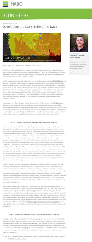
  • 1. FRIDAY, OCTOBER 25, 2019 Developing the Story Behind the Data Written by Bill Bass, GISP, Geospatial & Analytics Senior Manager HARC’s team of geospatial and analytics researchers spend significant time developing and analyzing data to unlock value and communicate information to a diverse audience. Whether the resulting products are written reports, report cards, data dashboards, analytical tools or narratives called Story Maps, there is something for everyone interested in the research conducted by HARC. HARC leverages a suite of geospatial and analytical tools from industry leaders such as ESRI, SAS, Tableau, and Microsoft. The software and services from each of these companies provide strong capabilities as individual systems, but when integrated to provide geospatial data development and analytical workflows, a value greater than the sum of its parts is realized. Analyses require access to high quality data, and HARC leverages a variety of authoritative datasets collected from private and non-profit sectors, as well as federal, state, and regional agencies. Many of these data are publicly funded at a fraction of the cost compared to obtaining data from private sources, and is in turn, delivered at little cost to the public. The public funding of data development allows research organizations like HARC to focus resources on data analysis and the creation of usable information products. One example of how HARC integrates multiple data systems is in the development of HARC's Land Cover Change story map. Within this interactive application, viewers can obtain information by watershed on regional changes to impervious cover, developed lands, forests, wetlands, and other types of land cover. Data in the story map were produced using an integrated workflow across multiple software platforms, leveraging each for its strengths to produce the final product. The result is a guided narrative on changes to regional land cover that also delivers access to statistical information for those wanting to explore data in greater detail. HARC’sHARC’s Houston-Galveston & Southeast Texas Land Cover Story MapHouston-Galveston & Southeast Texas Land Cover Story Map Conducting analyses as described above would not be possible without access to large scale federal and state datasets like the National Oceanic and Atmospheric Administration’s Coastal Change and Analysis Program NOAA’s C-CAP Land Cover land cover or the Texas Commission on Environmental Quality’s Surface Water Quality Monitoring Information System or the TCEQ SWQMIS water quality databases. Understanding our natural environment, environmental risks, and changes to our ecosystems are near impossible without access to these databases; and without these programs, collection would be cost prohibitive and rely upon private funding. These programs provide a vast wealth of information that academic, nonprofit, and private sector entities can leverage in understanding a changing world. Another example is Light Detection and Ranging (LiDAR) data, a remote sensing, data collection technology that has traditionally been used in determining ground elevations. HARC has recently been working on models and workflows to extract other important data from this dataset, such as land cover classification and tree canopy coverage. Innovative programs and processes such as these will help to produce new information products that can be leveraged in a variety of ways beyond their initial use cases. Ultimately, access to these data and the development of new information products allows for a consistent and standardized framework upon which partners can leverage resources and expertise, provides better inputs to decision making processes, and creates stronger opportunities for public education and community outreach and engagement. At HARC, collecting data is just the beginning. The real value is created when data are combined with new information from other sources to find relationships not previously known. HARC’s extensive geospatial systems architecture provides a platform upon which research teams can develop innovative and engaging information products. No longer does a system need to be installed and configured to meet the needs of a single project, which takes time and resources from the core focus of the research project. HARC’s integrated geospatial capabilities allows our researchers to develop, analyze, and share information in a visually compelling way through maps, graphs, and visualizations using a platform that can be leveraged in an on-going manner. This enables a reduced time to market for research projects and allows researchers to focus on the analysis and content aspects of the project. When a natural disaster strikes, there is often a gap in information describing environmental impacts. In August 2017 Hurricane Harvey, a devastating hurricane and flood event, struck the Upper Texas Coast. Media reports of Harvey’s impact on the Houston-Galveston region in terms of damage to life, property and communities were immediate. However, information on environmental impacts was less evident. A number of organizations actively collected hydrologic, air quality, and water quality data throughout the region while the natural disaster unfolded. The stories of what those data represented needed to be told in a manner that could quickly reach a broad audience. Using HARC’s geospatial and analytics platform, researchers were able to collect data, process it, and develop the interactive Summarizing Hurricane Harvey’s Environmental Impacts, story map, helping individual users and other organizations in the region access and understand information and take needed action. HARC's Summarizing Hurricane Harvey's Environmental ImpactsHARC's Summarizing Hurricane Harvey's Environmental Impacts Story MapStory Map HARC's geospatial and analytics capabilities allow for a higher degree of interactivity with project stakeholders and business partners. In a recent research project, HARC business partners and project stakeholders accessed web-based maps that allowed them to see the analysis products being generated by HARC during development. This type of interaction facilitated an iterative feedback loop between business partners, stakeholders, and the HARC research team, thereby allowing the project to adjust end products as project needs evolved. Throughout the process, and through various adjustments, HARC produced a final product that exceeded the needs of stakeholders and partners. To view HARC’s geospatial products and learn more about our capabilities, visit GIS.HARCresearch.org, or e- mail us at HARCGIS@HARCresearch.org. Bill Bass, GISP Geospatial & AnalyticsGeospatial & Analytics Senior ManagerSenior Manager Bill Bass is a Certified GIS professional and has extensive experience in geospatial technologies, project management, and enterprise solutions. TELLING THE DATA STORY HARC's Geospatial and Analytics team utilize data to share information in a compelling way. OUR BLOGOUR BLOG