Beginners Guide to TikTok for Search - Rachel Pearson - We are Tilt __ Bright...
181 Beachcomber Lane
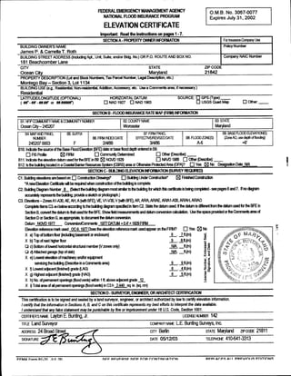
1. FEDERALEMERGENCYMANAGEMENTAGENCY B
M
O No 3067
0077
NATIONAL FLOOD INSURANCE PROGRAM 2002
F July 31
cpires
ELEVATION CERTIFICATE
Impo Read the instructions on pages 1 7
SECTION A PROPERTY OYVNER INFORMATION Far Itsutanx Company Use
BUILDING OWNER NAME
S Na rvumner
Y
James P Lamella T Roth
BUILDING STREET ADDRESS Including Apt Unit Suite and Bldg No OR P ROUTE
or O AND BOX NO Company NAtC Number
181 Beachcomber Lane
CITY STATE ZIP CODE
Ocean City Maryland 21842
PROPERTY DESCRIPTION Lot and Block Numbers Tax Parcel Number Legal Description etc
Montego Bay Section 3 Lot 1134
BUILDING USE eResidential Nonresidential Addition Accessory etc Use a Commerus area if r
g ecessary
Residential
LONGITUDE
LATITUDE OPTIONAL HORIZONTAL DATUM SOURCE GPS Type
tf R
p or NAD 1927 NAD 1983 USGS Quad Map Other
FLOOD INSURANCE RATE MAP
sECnoN a FIRM INFORManoN
81 NFIP COMMUNITY NAME 1NITY
COMIv NUMBER 82 COUNTY NAME 63 STATE
Ocean City
245207 Worcester Maryland
84 MAP AND PANEL t35 SUFFIX B7 FIRM PANEL B9 BASE FLOOD ELEVATION
S
NUMBER B6 FIRM INDEX DATE EFFECTNFJREVISEDbATE 88 FLOOD ZONE
S ZaneA0 use depth of flaocing
2452070003 F 88
4
2 6
4
3 6
A 6
B10 Inrjcafie the sarce of the Base Flood Elevation BFE data or base flood depth entered in 69
FIS Profile FIRM Carrnurtily Determined er e
Oti Descri
611 Irxicate the elevation dahm used for me BFE in Bs NGVD 1929 NAVD 1988 er e
Ofl Descr
612 Is the buidmg Iocaled in a Coastal Barrier Resouces Sys CBRS arm aOtherwise Protected Ar OPA
a3 Yes No Designafion Date NfA
irl
SECTION C BULDING ELEVATION INFORMATION SURVEY REQURED
c1 Bluking elevations are based oa ction
Constn Dlawings BIg Udder Cortstructiorl Fnistted Catsinxtim
A newElevation Cefificaie wit be requied when carlstruction of the
s plete
bulcing car
C2 Bullring Diagarn Number 8 Select the brikirlg diagarnmost smiar tothe brild wtrch this certifirabe isbeingcompleted seepages 6 and 7
mgfar ff no d
egrarn
aoarafiey represents the buidng provide a sketch ar ptlatogaph
C3 EIEVations Al AE AH A wish BFE VE V1 V30 V with BFE AR AR AWAE ARJA1 AR AR
ZonesA30 A A30 AHAO
If the dahrrrs dlfteent finrUte datum used fa the BFE in
Cample6e Items C3 bebw aocorcirg to the buidntg riagram specfied m Item C2 S1a the dalrrrt used
i
a
Section B convert tits datrrt io that used fa the BFE Showfield rl
rerterllsand dahm conversion cakxllation lke the space provided ar the Camarea
er11s of
Section D or Section G as apprapriatie to doarrterlt the dahm oorruesion
Daitm NGUD 1977 ConversioruCamrterlls 1977 DATUM 0 1929 FIRM
4
Elevation reference marts used OC Does the elevation refiererlce mark used appeir an the FIRM
1977
9 Yes No
X a Tap of bottom fbar ndudrg basement aend 6 7 m
ft
X 9 8 iL
m
b Top of next highs floor
c Bottom of lowest horstnicfiral rlerrlber N
ordal ony wA m
ft S
d Athached garage topof slab wa m
ft W
X e Lowest elevation of
rlacttirtey arxilar equQr
ent m
9 9 ft
m
seviang the buidilg Desc ina Carrnenis area
tbe
X 6 4 ft
m s
f Lowest adlacelt finished Bade LAG
X 6 5 ft
m 3
g Highest adjacent finished grade FiAG
tc
X 3sflood verbs wifl ft above adjacent grade 12
h No of Permanent operrrx in1 y a
X Total area of all perrrarlelt openings flood vents in C3 2 sc in sq an
h 440
SECTION D SURVEYOR ENgNEER OR ARCHTECT CERiIRCATION
This certification isto be signed and sealed a land surveyor engineer or architect authorized by law to certify elevation informeton
by
I certify that the Information in Sections A B and C on this certificate represents my best efforts to interpret the data available
t understand that any false statement maybe punishable by fine or imprisonment under 18 U Code Section 1001
S
s
cERTIFIER NAME Layton E Bunting Jr ucENSE NUMBER 142
TITLE Land SuNeyor COMPANY NAME E
L Bunting Surveys Inc
ADDRESS 24 Broad Street J CITY Befllrt STATE Maryland ZIPCODE 21811
SIGNATURE DATE 03
12
05 tCNE 3313
TELEPI 41041
RFPI AC AI I S
PRFVIr1I1 FI
11TIrlNR
FFMA Fnrm R1 1111 r1n
7 CFF RFVFRF RIIIF FC1R rr1NTIN11ATIr1N
F FC
2. IMPORTANT In these spaces copythe fromSection A
oonesponding information For Inswarlce
Company Use
BUILDING STREET ADDRESS Inclu
ngApi Unif Sute andror Bldg No OR P ROUTE AND BOXNO
O Number
181 Beachcomber Lane
CfIY ZIP CCDE
STATE Compary NAIC Number
Ocean City Maryland 21842
SECTION D SURVEYOR ENgNIEER OR ARCHTf ECi CERi1RCAT10N
CONTINUED
Copy both sides of this Elevation Certificate for 1 corrmunil ot6dal 2 Ir1Slf agentfcorrlparry
r Ce
d and bulking owner
COMMENTS
The elevation of the attached shed floc is 7 This shed has 2 additional flood vertts
t7
Check here ifattachrr
ents
SECTION E DING
BUII ELEVATION INFORMATION SURVEY NOT REQURED FORZONE AiO AND ZONE A WITHOUT 8FE
For ZaneAO and Zane A wittlout BFE arnplete Items E1 E4 If the Elevatal Certificate isirdendedfor use as
supporting irdar for a LOMA a LOMB
ation F
Section C must be completed
E1 Bliking Diagam Number the buikirgdiagrarl most sirilar to the blikirlg for wtidlthis certifiratesbeing corpleted seepages 6 and
Seled 7 ff no diagarn accuatey
represents the buidng provide a sketch aptlotograph
E2 The top of the tx
tbrrl floor educing baserrlelt aendosure of the txildng is mkl
ft an above a bebw check one the highest adjacent grade Nse
nahral grade available
E3 Far Bulking Diagrams ti wish openirxfs see page 7J the next higher floor a
8 elevated floes elevation b of the txikieg is
ft anabove the higher adjacent
min
grade Complete items q and qa an front of farm
h
E4 Far Zone AO aiy If no flood depth number available s the top of the botrorn tkxxelevrated in accordance with the
s camlunihls lloodptatr managerrlerlt ardearlce
Yes No Uricnown The local otfiaal must ths infarrlation in Section G
SECTION F PROPERTY OWNER OR OWNER
S
REPRESENTATIVE CERTIRCATION
The owner a owner authored
s who
property representative es
corpl Sections 1 B C Items q and C3 only and E for Zone A wiU a
h i out a carrrrlunily
ed
isst BFE aZane AOmust sign here Thestatemlents in Sections A B C and E are cared th the best of my knowledge
PROPERTY OWNER
S S ED S
OWNER AUTFIOR REPRESENTATNE IJAME
CITY STATE ZIPCODE
SIGNATURE DATE TELEPHONE
OMMQVTS
Check here ifattactrr
ants
sECTION c coMMUNTY IIvPnoNAy
ORMATION
The kxxl otfiaal who aulha by law a adirranoe th artrnirister the corrr7lur tlooc marragernent ortinarlce can
s ed s
fiy lain Sectias A B C aE and G of this Elevation
Certificate Carpl the applicable item
e and
s sign below
G1 The infarnation inSection C was taken fran other docuner that hasbeen
iatiorl signed and errlbossed by aGcersed surveys elgkieer aarchitect who autha by
s ed
state abcal lawto certify elevation irlfonrration Indicate the sores and date of the elevation data th theCanrnenls area below
GL A corrmunily official cgrrlpletedSection Efor a buid bZone Aa FQNAi5SU8d a
rlgbated without oormwrity 8FE ar Zone A0
issued
q The folowrlg infometion Items G4 is prarided far carrrxrrty tbodplain
G9 marragerrlent purposes
PERMIT NUMBER
G7 This pewit has been issued tor New Construction Subsiantlal nent
Impvve
G8 Elevation of as barest floor
Milt of the bui is
ndudng baserrlen ng m
ft Datum
Gg BFE apn Zone AO depth of tkxxing at the buikirly site s
m
ft Datum
LOCAL OFFICIAL NAME
S TfiLE
COMMUNITY NAME TELEPHONE
SIGNATURE DATE
COMMENTS
chere rf attachments
Chex
FFMA Fnrm R1 31 1111 rNl RFPI A Al I
FC SFI
PRFVIn11 1171f1NR