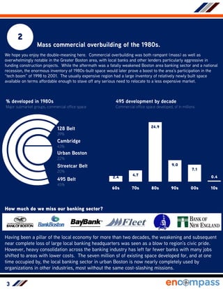
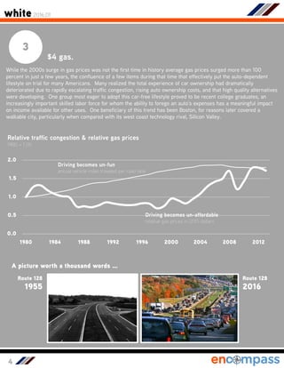
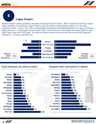
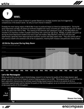
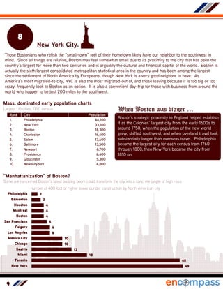
white by encompass
white 2016.01
Why Boston Why Now?
People are starting to think “The Hub of the Universe” may just be exactly that –
and not just people living within the 495 Belt. We’ve had MIT and Harvard here
for centuries and the city’s geography and positioning within New England hasn’t
changed. So what is the particular set of ingredients that lead us to where we
are today? Boston is not the victim of rapid corporate consolidation with its
“second-fiddle” to San Francisco status in technology that it was in the early
2000s. Encompass is taking a crack at the ten leading reasons, the ten dominant
ingredients, that lead Boston to its position today.
May 2016spectrum family
Brendan Carroll <> Director of Intelligence
2
1
The Cold War.
Long before the confluence of modern battery
life, the touchscreen, digital communications
and iTunes, the US Government was by far the
largest investor, researcher and purchaser of
technologies worldwide. MIT, having been the
Government’s largest research contractor
during World War II, became super-sized from
World War II until the fall of communism in
1989. The Government spent $9.5 trillion on
the development of technology in a “spare no
expense” attitude to stay ahead of whatever
the enemy was developing on the other side of
earth. MIT remained the government’s largest
contractor during this period and co-founded
many joint operations, such as Draper
Laboratories, Lincoln Labs and MITRE. These
efforts resulted in the development of many
technologies which have been heavily
commercialized today, such as GPS, which
may not have ever been established if for-
profit were the driver right off the bat.
Were wars, and the Cold War, responsible for America’s Technology Highway?
Still a popular franchise today, James Bond movies,
along with the perennial villain Blofeld & his cats,
were a staple for much of the cold war period.
1941
Raytheon, founded in 1919, moves to
Waltham and becomes producer of
missiles and early GPS technology.
While suburban office clusters developed around nearly all American
cities in the period after World War II, the Boston cluster in the western
suburbs was notably earlier than most other areas and has carried a
prestigious cache not found nearly anywhere else. The reasoning can
be traced to a propensity for government wartime research efforts to be
located near MIT, but far enough away from campuses and dense areas
to stave off distracting protests and other activities.
1951
Lincoln Laboratory
founded in Lincoln by MIT
to focus on air defense.
1958
MITRE founded as a spin-off of Lincoln
Laboratory to administer nation’s SAGE
air surveillance program.
white 2016.01
3
2
Mass commercial overbuilding of the 1980s.
We hope you enjoy the double-meaning here. Commercial overbuilding was both rampant (mass) as well as
overwhelmingly notable in the Greater Boston area, with local banks and other lenders particularly aggressive in
funding construction projects. While the aftermath was a fatally weakened Boston area banking sector and a national
recession, the enormous inventory of 1980s-built space would later prove a boost to the area’s participation in the
“tech boom” of 1998 to 2001. The usually expensive region had a large inventory of relatively newly built space
available on terms affordable enough to stave off any serious need to relocate to a less expensive market.
How much do we miss our banking sector?
% developed in 1980s
Major submarket groups, commercial office space
495 development by decade
Commercial office space developed, sf in millions
Urban Boston
22%
Cambridge
43%
Streetcar Belt
20%
495 Belt
45%
128 Belt
39%
2.4
4.7
24.9
9.0
7.1
0.4
60s 70s 80s 90s 00s 10s
Having been a pillar of the local economy for more than two decades, the weakening and subsequent
near complete loss of large local banking headquarters was seen as a blow to region’s civic pride.
However, heavy consolidation across the banking industry has left far fewer banks with many jobs
shifted to areas with lower costs. The seven million sf of existing space developed for, and at one
time occupied by, the local banking sector in urban Boston is now nearly completely used by
organizations in other industries, most without the same cost-slashing missions.
4
3
$4 gas.
While the 2000s surge in gas prices was not the first time in history average gas prices surged more than 100
percent in just a few years, the confluence of a few items during that time that effectively put the auto-dependent
lifestyle on trial for many Americans. Many realized the total experience of car ownership had dramatically
deteriorated due to rapidly escalating traffic congestion, rising auto ownership costs, and that high quality alternatives
were developing. One group most eager to adopt this car-free lifestyle proved to be recent college graduates, an
increasingly important skilled labor force for whom the ability to forego an auto’s expenses has a meaningful impact
on income available for other uses. One beneficiary of this trend has been Boston, for reasons later covered a
walkable city, particularly when compared with its west coast technology rival, Silicon Valley.
Route 128
1955
A picture worth a thousand words …
Route 128
2016
Relative traffic congestion & relative gas prices
1980 = 1.00
0.0
0.5
1.0
1.5
2.0
1980 1984 1988 1992 1996 2000 2004 2008 2012
Driving becomes un-fun
annual vehicle miles traveled per road lane
Driving becomes un-affordable
relative gas prices in 2015 dollars
white 2016.01
5
4
The Auto Industry
While discussions surrounding the auto
industry’s practices in the mid-1900s
continue a half-century later, the auto
industry, and their best friends the tire
and oil industries, were not fans of
live/work/play environments. Initially
touting the freedom a car could provide
from urban grime, the powerful and
coordinated set of industries made sure
the car would be a symbol of the
American way of life. The industry’s
near-ubiquitous success in establishing
the car as the only reasonable method of
transit in most American cities, and their
near-miraculous failure to do so in
Boston, left Boston one of the few
walking cities left in the second half of the
20th century. With current trends wildly
favoring cities with substantial walkable
living environments, this distinction has
vaunted Boston’s competitiveness in
recent years (more on transit to come).
Henry Ford
The General Motors Streetcar Conspiracy
Sometimes lauded as the auto industry’s most aggressive competitive tactic was the wide scale
acquisitions of streetcars systems in the United States by General Motors and Goodyear Tire and
Rubber Company. From 1950 to 1962, the two
acquired a total of 95 systems throughout the
country, in most cases immediately shutting down
the systems and replacing routes with bus lines,
services with dramatically lower rider satisfaction
characteristics. Being viewed as the leader of the
trend, General Motors was the only party ever
sued by in court, where they were found not guilty
of conspiracy in connection with the shutdown of
the Los Angeles system, but remained under
review of the government.
6
5
Logan Airport.
Boston’s longest-running competitive advantage remains proximity to Europe. While it remains the country’s closest
major metropolis to the continent, Logan Airport is also the country’s most proximate airport to its host city’s
commercial center – by far! The result is a compounded convenience for European proximity in an age of increasing
global commerce. In meaningfully connecting the “Hub” to Asia for the first time, Boston now boasts flights to eight
Asian cities, along with 17 in Europe. The only city in North America to have at least that many to each respective
continent is … of course, New York City.
Boston
New York City
Chicago
Los Angeles
Washington DC
San Francisco
Nonstop
Asian
Destinations
Nonstop
European
Destinations
17
28
16
14
13
10
8
15
11
16
7
17
Travel allowance city center to airport
High end of travel range from city center to airport at 5:30pm
100
75
65
55
50
45
45
35
35
30
30
30
28
28
10
New York
Los Angeles
Washington
Chicago
Dallas
Miami
Atlanta
San Francisco
Houston
Philadelphia
Seattle
Minneapolis
Detroit
Cleveland
Boston
minutes, 15 largest CMSAs
European travel inconvenience vs Boston
Additional time required for travel to London vs Boston*
minutes, 15 largest CMSAs
310
270
223
215
190
190
160
140
125
125
120
109
105
50
Los Angeles
San Francisco
Cleveland
Seattle
Dallas
Houston
Miami
Atlanta
Chicago
Minneapolis
New York
Detroit
Washington
Philadelphia
*factoring in shortest scheduled travel time and airport transit
white 2016.01
7
6
The Red Line.
Everyone loves the Red Line these days. And why not? The region’s most heavily used
rapid transit line serves 273,000 passengers per day but also connects the region’s
commercial cores with world famous universities, New England’s largest transit hub and
nearly every type and level of skilled professional. There may be one often overlooked
characteristic here, however … it moves. Board the Red Line and fifteen minutes later
you’re five miles away from where you got on. The Red Line’s ability to efficiently move
passengers throughout the region and provide a clear advantage over auto and other types
of transport during peak times has given it clear favor in the eyes of the region’s users.
Average line speeds by MBTA rail line
Peak hour travel averages
9
15
18
21
green
blue
orange
red
mph
Hey! Where do the trains go??
The elevated section of the Red Line which crosses the
Charles River over the Longfellow Bridge is a prized
moment for passengers to steel away some daylight
and a nice view of the Back Bay during an otherwise
underground eight-mile stretch between Alewife and
JFK/Umass stations. The bridge, which was
completed in 1906, was built to accommodate the
planned subway but the subway remained unfunded
until the 1920s, meaning that the bridge was built with
tracks ending on either side into a dead-end.
Construction started on the Cambridge subway in the
early 1920s and heavy rail rapid transit trains began
crossing the Charles River here in 1932.
When in doubt, look for Red.
Not only is our Red Line the busiest heavy rail line in its
system, but Red Lines are nearly always the busiest, in
US subway systems which identify their lines by color.
This holds for the systems in Chicago, Washington,
Atlanta, Los Angeles and others. New York’s subway
does not refer to its lines by color but its busiest line –
the 1, 2, 3 … appears in red on its map. Want to cross
the pond? London’s Central Line and Paris’ RER-A, yes,
Red.
1 2 3
8
7
WWII.
white 2016.01
Few dispute the current wave of interest in greater Boston as a strategic location was first triggered by
competencies in the biotech world. So why so much interest in biotech?
Probably the most lasting impact of World War II was its profound impact on American demographics. During the
Great Depression and War, the American birthrate dropped from nearly 3.5 births per 1,000 people per year to about
2.1, for the years from 1931 to 1946. This slowing of the birthrate and subsequent surge, uh, the Baby Boom era,
resulted in an enormous number of people associating with a particular age group. Notably, as people who grew up
during the Great Depression tended to be more frugal and modest, Baby Boomers (now 50 to 69 years old)
experienced a generally more robust period of economic success and today expect more. They also control xx% of
the country’s wealth and constitute xx% of the its population, meaning both investors and politicians listen to them.
1910 1914 1918 1922 1926 1930 1934 1938 1942 1946 1950 1954 1958 1962 1966 1970 1974
3.0 mm
US Births Skyrocket During Baby Boom
millions of live births per year
4.0 mm
5.0 mm
74 million births
Let’s Get Rectangular
While much of the current surge in biotechnology research is to improve the quality of life of baby-boomer aged
people, you won’t find a lot of research aimed at helping people to live to 200. “Rectangularization” is a term that has
been used which characterizes the attitude toward therapy-based research; the aim is to extend all life to a
reasonable expected point and to improve the quality of that life throughout, so as to eliminate any protracted periods
of decreased quality of life throughout.
% of
people
0
100
Age
Disease-free living
9
8
New York City.
Those Bostonians who relish the “small-town” feel of their hometown likely have our neighbor to the southwest in
mind. Since all things are relative, Boston may feel somewhat small due to its proximity to the city that has been the
country’s largest for more than two centuries and is arguably the cultural and financial capital of the world. Boston is
actually the sixth largest consolidated metropolitan statistical area in the country and has been among the largest
since the settlement of North America by Europeans, though New York is a very good neighbor to have. As
America’s most migrated-to city, NYC is also the most migrated-out of, and those leaving because it is too big or too
crazy, frequently look to Boston as an option. It is also a convenient day-trip for those with business from around the
world who happen to be just 200 miles to the southwest.
“Manhattanization” of Boston?
Some are concerned Boston’s latest building boom could transform the city into a concrete jungle of high rises
49
48
18
13
10
10
6
6
5
4
4
4
3
2
New York
Toronto
Miami
Seattle
Chicago
Mexico City
Los Angeles
Calgary
San Francisco
Boston
Montreal
Houston
Edmonton
Philadelphia
number of 400 foot or higher towers under construction by North American city
When Boston was bigger …
Boston’s strategic proximity to England helped establish
it as the Colonies’ largest city from the early 1600s to
around 1750, when the population of the new world
grew, shifted southwest, and when overland travel took
substantially longer than overseas travel. Philadelphia
became the largest city for each census from 1760
through 1800, then New York became the city from
1810 on.
Rank City Population
1. Philadelphia 44,100
2. New York 33,100
3. Boston 18,300
4. Charleston 16,400
5. Salem 13,600
6. Baltimore 13,500
7. Newport 6,700
8. Providence 6,400
9. Gloucester 5,300
10. Newburyport 4,800
Mass. dominated early population charts
Largest US cities, 1790 census
10
9
Freeway Protests.
The building of the Interstate and other
highway systems in the 1950s and 60s
caused many clashes between elected
officials and residents whose
neighborhoods were undergoing heavy
demolition to make way for the new roads.
Unsurprisingly, those clashes were
particularly heated in the Boston area.
Then-governor Francis Sargent ultimately
placed a moratorium on new highway
construction within Route 128 in 1971, after
Interstate 93 and the Massachusetts
Turnpike extension had been fully built, but
stranding numerous freeway projects that
had been in various phases of planning and
development. The bold move ultimately
saved numerous key areas within the urban
fabric of the city, and necessitated public
agencies maintain commuter rail and other
public transit infrastructure which could
have been scuttled had Boston become the
car mecca at the time it was envisioned.
white 2016.01
Boston’s Freeway Graveyard
Innerbelt Freeway
Demolished right-of-way includes Melnea Cass Blvd
and Somerville’s Inner Belt Park, would have
demolished much of Cambridge’s Central Square.
Southwest Expressway
The Orange Line and Northeast Corridor train tracks
out of Back Bay Station follow a path that was
cleared for the Interstate’s path through town.
Northeast Expressway
US Route 1 north of Boston generally follows the path
of the planned 95, though straightening and widening
would have demolished hundreds of homes.
Northwest Expressway
Mass Route 2 was roughly half constructed, though
the highway’s path through Cambridge was halted,
which would have cut through much of the city.
Boston’s cancelled freeway projects
OMG That Expressway Traffic!!!
While heavy traffic is common on the region’s roadways
there is a particular dread of using Interstate 93 at any
point other than in the middle of the night. The
problem is real – serving more than 200,000 cars
daily, the freeway is region’s busiest, among the most
chronically delayed in the country, and is relatively
unusual in that it has fewer lanes than roads that carry
comparable loads. Why is this freeway special – well,
probably for the freeway you see in this picture. The
never-built Southwest Expressway, stopped here at the
Route 128/Interstate 95 interchange in Canton. The
canceling of this freeway has effectively made I-93 do
double-duty, with no relief valve in sight.
11
10
The T.R. (or maybe T.B.)
It could be argued that the New England Patriots’ win in 2002’s Super Bowl XXXVI enabled by their win in the “Tuck
Rule Game” may have exorcised some demons and elevated the level of expectations for our other sports teams.
However, the effect of the 359 postseason games played by the city’s four professional sports teams is beyond
argument. With nearly all those contests featured on national television, the city has been continually and
prominently displayed in front of a national audience during a particularly transformational period of the city’s appeal,
including the upgrade of the waterfront area, demolition of the central artery and other things. The sports success
has also caused a dramatic increase in patronage of the city’s eating and drinking establishments, helping spur
expansions in that sector far more robust than seen in other sectors. Growth in food & beverage employment has
nearly doubled since 2002 when compared with the prior twelve years, and the sector has now expanded by 52
percent. Oh, and how have local teams faired in those 359 contests – we’ve won 56 percent of them; a lot better
than the 34 percent we won in the 77 contests leading up to the T.R. Game.
0
2
4
6
8
10
bos la ny chi sf mia sa det pit stl dal den bal gb
All of the sudden – Championships!
Yes, the nine championships enjoyed by area sports teams since 2002 is the most among North American cities –
more than double any other city than Los Angeles. Unique on this list is that every team having won since 2002 also
won at least one championship in the 1990-2001 period.
number of championships, four major professional sports, given time period, given city abbreviation
1990 - 2001
2002 – Mar ‘16
Before T.R./T.B. (1993-2001) Ever Since
number of postseason games 8.6 23.9
number of postseason wins 2.9 13.5
Championship appearances 0.1 0.9
Championship wins 0.0 0.6
Postseason win % 34% 56%
Brendan Carroll <> President | Director of Intelligence <> brendan@encompasscre.com
© 2016 Encompass Real Estate Strategy LLC. All Rights Reserved.
spectrum family
blue <> macro level office | quarterly
steel <> macro level industrial | quarterly
green <> macro level laboratory | quarterly
slate <> submarket level office series | quarterly
node <> transit-accessible office & lab | twice-yearly
white <> investment sales | twice-yearly or so

White 2016.1

  • 1.
    white by encompass white2016.01 Why Boston Why Now? People are starting to think “The Hub of the Universe” may just be exactly that – and not just people living within the 495 Belt. We’ve had MIT and Harvard here for centuries and the city’s geography and positioning within New England hasn’t changed. So what is the particular set of ingredients that lead us to where we are today? Boston is not the victim of rapid corporate consolidation with its “second-fiddle” to San Francisco status in technology that it was in the early 2000s. Encompass is taking a crack at the ten leading reasons, the ten dominant ingredients, that lead Boston to its position today. May 2016spectrum family Brendan Carroll <> Director of Intelligence
  • 2.
    2 1 The Cold War. Longbefore the confluence of modern battery life, the touchscreen, digital communications and iTunes, the US Government was by far the largest investor, researcher and purchaser of technologies worldwide. MIT, having been the Government’s largest research contractor during World War II, became super-sized from World War II until the fall of communism in 1989. The Government spent $9.5 trillion on the development of technology in a “spare no expense” attitude to stay ahead of whatever the enemy was developing on the other side of earth. MIT remained the government’s largest contractor during this period and co-founded many joint operations, such as Draper Laboratories, Lincoln Labs and MITRE. These efforts resulted in the development of many technologies which have been heavily commercialized today, such as GPS, which may not have ever been established if for- profit were the driver right off the bat. Were wars, and the Cold War, responsible for America’s Technology Highway? Still a popular franchise today, James Bond movies, along with the perennial villain Blofeld & his cats, were a staple for much of the cold war period. 1941 Raytheon, founded in 1919, moves to Waltham and becomes producer of missiles and early GPS technology. While suburban office clusters developed around nearly all American cities in the period after World War II, the Boston cluster in the western suburbs was notably earlier than most other areas and has carried a prestigious cache not found nearly anywhere else. The reasoning can be traced to a propensity for government wartime research efforts to be located near MIT, but far enough away from campuses and dense areas to stave off distracting protests and other activities. 1951 Lincoln Laboratory founded in Lincoln by MIT to focus on air defense. 1958 MITRE founded as a spin-off of Lincoln Laboratory to administer nation’s SAGE air surveillance program. white 2016.01
  • 3.
    3 2 Mass commercial overbuildingof the 1980s. We hope you enjoy the double-meaning here. Commercial overbuilding was both rampant (mass) as well as overwhelmingly notable in the Greater Boston area, with local banks and other lenders particularly aggressive in funding construction projects. While the aftermath was a fatally weakened Boston area banking sector and a national recession, the enormous inventory of 1980s-built space would later prove a boost to the area’s participation in the “tech boom” of 1998 to 2001. The usually expensive region had a large inventory of relatively newly built space available on terms affordable enough to stave off any serious need to relocate to a less expensive market. How much do we miss our banking sector? % developed in 1980s Major submarket groups, commercial office space 495 development by decade Commercial office space developed, sf in millions Urban Boston 22% Cambridge 43% Streetcar Belt 20% 495 Belt 45% 128 Belt 39% 2.4 4.7 24.9 9.0 7.1 0.4 60s 70s 80s 90s 00s 10s Having been a pillar of the local economy for more than two decades, the weakening and subsequent near complete loss of large local banking headquarters was seen as a blow to region’s civic pride. However, heavy consolidation across the banking industry has left far fewer banks with many jobs shifted to areas with lower costs. The seven million sf of existing space developed for, and at one time occupied by, the local banking sector in urban Boston is now nearly completely used by organizations in other industries, most without the same cost-slashing missions.
  • 4.
    4 3 $4 gas. While the2000s surge in gas prices was not the first time in history average gas prices surged more than 100 percent in just a few years, the confluence of a few items during that time that effectively put the auto-dependent lifestyle on trial for many Americans. Many realized the total experience of car ownership had dramatically deteriorated due to rapidly escalating traffic congestion, rising auto ownership costs, and that high quality alternatives were developing. One group most eager to adopt this car-free lifestyle proved to be recent college graduates, an increasingly important skilled labor force for whom the ability to forego an auto’s expenses has a meaningful impact on income available for other uses. One beneficiary of this trend has been Boston, for reasons later covered a walkable city, particularly when compared with its west coast technology rival, Silicon Valley. Route 128 1955 A picture worth a thousand words … Route 128 2016 Relative traffic congestion & relative gas prices 1980 = 1.00 0.0 0.5 1.0 1.5 2.0 1980 1984 1988 1992 1996 2000 2004 2008 2012 Driving becomes un-fun annual vehicle miles traveled per road lane Driving becomes un-affordable relative gas prices in 2015 dollars white 2016.01
  • 5.
    5 4 The Auto Industry Whilediscussions surrounding the auto industry’s practices in the mid-1900s continue a half-century later, the auto industry, and their best friends the tire and oil industries, were not fans of live/work/play environments. Initially touting the freedom a car could provide from urban grime, the powerful and coordinated set of industries made sure the car would be a symbol of the American way of life. The industry’s near-ubiquitous success in establishing the car as the only reasonable method of transit in most American cities, and their near-miraculous failure to do so in Boston, left Boston one of the few walking cities left in the second half of the 20th century. With current trends wildly favoring cities with substantial walkable living environments, this distinction has vaunted Boston’s competitiveness in recent years (more on transit to come). Henry Ford The General Motors Streetcar Conspiracy Sometimes lauded as the auto industry’s most aggressive competitive tactic was the wide scale acquisitions of streetcars systems in the United States by General Motors and Goodyear Tire and Rubber Company. From 1950 to 1962, the two acquired a total of 95 systems throughout the country, in most cases immediately shutting down the systems and replacing routes with bus lines, services with dramatically lower rider satisfaction characteristics. Being viewed as the leader of the trend, General Motors was the only party ever sued by in court, where they were found not guilty of conspiracy in connection with the shutdown of the Los Angeles system, but remained under review of the government.
  • 6.
    6 5 Logan Airport. Boston’s longest-runningcompetitive advantage remains proximity to Europe. While it remains the country’s closest major metropolis to the continent, Logan Airport is also the country’s most proximate airport to its host city’s commercial center – by far! The result is a compounded convenience for European proximity in an age of increasing global commerce. In meaningfully connecting the “Hub” to Asia for the first time, Boston now boasts flights to eight Asian cities, along with 17 in Europe. The only city in North America to have at least that many to each respective continent is … of course, New York City. Boston New York City Chicago Los Angeles Washington DC San Francisco Nonstop Asian Destinations Nonstop European Destinations 17 28 16 14 13 10 8 15 11 16 7 17 Travel allowance city center to airport High end of travel range from city center to airport at 5:30pm 100 75 65 55 50 45 45 35 35 30 30 30 28 28 10 New York Los Angeles Washington Chicago Dallas Miami Atlanta San Francisco Houston Philadelphia Seattle Minneapolis Detroit Cleveland Boston minutes, 15 largest CMSAs European travel inconvenience vs Boston Additional time required for travel to London vs Boston* minutes, 15 largest CMSAs 310 270 223 215 190 190 160 140 125 125 120 109 105 50 Los Angeles San Francisco Cleveland Seattle Dallas Houston Miami Atlanta Chicago Minneapolis New York Detroit Washington Philadelphia *factoring in shortest scheduled travel time and airport transit white 2016.01
  • 7.
    7 6 The Red Line. Everyoneloves the Red Line these days. And why not? The region’s most heavily used rapid transit line serves 273,000 passengers per day but also connects the region’s commercial cores with world famous universities, New England’s largest transit hub and nearly every type and level of skilled professional. There may be one often overlooked characteristic here, however … it moves. Board the Red Line and fifteen minutes later you’re five miles away from where you got on. The Red Line’s ability to efficiently move passengers throughout the region and provide a clear advantage over auto and other types of transport during peak times has given it clear favor in the eyes of the region’s users. Average line speeds by MBTA rail line Peak hour travel averages 9 15 18 21 green blue orange red mph Hey! Where do the trains go?? The elevated section of the Red Line which crosses the Charles River over the Longfellow Bridge is a prized moment for passengers to steel away some daylight and a nice view of the Back Bay during an otherwise underground eight-mile stretch between Alewife and JFK/Umass stations. The bridge, which was completed in 1906, was built to accommodate the planned subway but the subway remained unfunded until the 1920s, meaning that the bridge was built with tracks ending on either side into a dead-end. Construction started on the Cambridge subway in the early 1920s and heavy rail rapid transit trains began crossing the Charles River here in 1932. When in doubt, look for Red. Not only is our Red Line the busiest heavy rail line in its system, but Red Lines are nearly always the busiest, in US subway systems which identify their lines by color. This holds for the systems in Chicago, Washington, Atlanta, Los Angeles and others. New York’s subway does not refer to its lines by color but its busiest line – the 1, 2, 3 … appears in red on its map. Want to cross the pond? London’s Central Line and Paris’ RER-A, yes, Red. 1 2 3
  • 8.
    8 7 WWII. white 2016.01 Few disputethe current wave of interest in greater Boston as a strategic location was first triggered by competencies in the biotech world. So why so much interest in biotech? Probably the most lasting impact of World War II was its profound impact on American demographics. During the Great Depression and War, the American birthrate dropped from nearly 3.5 births per 1,000 people per year to about 2.1, for the years from 1931 to 1946. This slowing of the birthrate and subsequent surge, uh, the Baby Boom era, resulted in an enormous number of people associating with a particular age group. Notably, as people who grew up during the Great Depression tended to be more frugal and modest, Baby Boomers (now 50 to 69 years old) experienced a generally more robust period of economic success and today expect more. They also control xx% of the country’s wealth and constitute xx% of the its population, meaning both investors and politicians listen to them. 1910 1914 1918 1922 1926 1930 1934 1938 1942 1946 1950 1954 1958 1962 1966 1970 1974 3.0 mm US Births Skyrocket During Baby Boom millions of live births per year 4.0 mm 5.0 mm 74 million births Let’s Get Rectangular While much of the current surge in biotechnology research is to improve the quality of life of baby-boomer aged people, you won’t find a lot of research aimed at helping people to live to 200. “Rectangularization” is a term that has been used which characterizes the attitude toward therapy-based research; the aim is to extend all life to a reasonable expected point and to improve the quality of that life throughout, so as to eliminate any protracted periods of decreased quality of life throughout. % of people 0 100 Age Disease-free living
  • 9.
    9 8 New York City. ThoseBostonians who relish the “small-town” feel of their hometown likely have our neighbor to the southwest in mind. Since all things are relative, Boston may feel somewhat small due to its proximity to the city that has been the country’s largest for more than two centuries and is arguably the cultural and financial capital of the world. Boston is actually the sixth largest consolidated metropolitan statistical area in the country and has been among the largest since the settlement of North America by Europeans, though New York is a very good neighbor to have. As America’s most migrated-to city, NYC is also the most migrated-out of, and those leaving because it is too big or too crazy, frequently look to Boston as an option. It is also a convenient day-trip for those with business from around the world who happen to be just 200 miles to the southwest. “Manhattanization” of Boston? Some are concerned Boston’s latest building boom could transform the city into a concrete jungle of high rises 49 48 18 13 10 10 6 6 5 4 4 4 3 2 New York Toronto Miami Seattle Chicago Mexico City Los Angeles Calgary San Francisco Boston Montreal Houston Edmonton Philadelphia number of 400 foot or higher towers under construction by North American city When Boston was bigger … Boston’s strategic proximity to England helped establish it as the Colonies’ largest city from the early 1600s to around 1750, when the population of the new world grew, shifted southwest, and when overland travel took substantially longer than overseas travel. Philadelphia became the largest city for each census from 1760 through 1800, then New York became the city from 1810 on. Rank City Population 1. Philadelphia 44,100 2. New York 33,100 3. Boston 18,300 4. Charleston 16,400 5. Salem 13,600 6. Baltimore 13,500 7. Newport 6,700 8. Providence 6,400 9. Gloucester 5,300 10. Newburyport 4,800 Mass. dominated early population charts Largest US cities, 1790 census
  • 10.
    10 9 Freeway Protests. The buildingof the Interstate and other highway systems in the 1950s and 60s caused many clashes between elected officials and residents whose neighborhoods were undergoing heavy demolition to make way for the new roads. Unsurprisingly, those clashes were particularly heated in the Boston area. Then-governor Francis Sargent ultimately placed a moratorium on new highway construction within Route 128 in 1971, after Interstate 93 and the Massachusetts Turnpike extension had been fully built, but stranding numerous freeway projects that had been in various phases of planning and development. The bold move ultimately saved numerous key areas within the urban fabric of the city, and necessitated public agencies maintain commuter rail and other public transit infrastructure which could have been scuttled had Boston become the car mecca at the time it was envisioned. white 2016.01 Boston’s Freeway Graveyard Innerbelt Freeway Demolished right-of-way includes Melnea Cass Blvd and Somerville’s Inner Belt Park, would have demolished much of Cambridge’s Central Square. Southwest Expressway The Orange Line and Northeast Corridor train tracks out of Back Bay Station follow a path that was cleared for the Interstate’s path through town. Northeast Expressway US Route 1 north of Boston generally follows the path of the planned 95, though straightening and widening would have demolished hundreds of homes. Northwest Expressway Mass Route 2 was roughly half constructed, though the highway’s path through Cambridge was halted, which would have cut through much of the city. Boston’s cancelled freeway projects OMG That Expressway Traffic!!! While heavy traffic is common on the region’s roadways there is a particular dread of using Interstate 93 at any point other than in the middle of the night. The problem is real – serving more than 200,000 cars daily, the freeway is region’s busiest, among the most chronically delayed in the country, and is relatively unusual in that it has fewer lanes than roads that carry comparable loads. Why is this freeway special – well, probably for the freeway you see in this picture. The never-built Southwest Expressway, stopped here at the Route 128/Interstate 95 interchange in Canton. The canceling of this freeway has effectively made I-93 do double-duty, with no relief valve in sight.
  • 11.
    11 10 The T.R. (ormaybe T.B.) It could be argued that the New England Patriots’ win in 2002’s Super Bowl XXXVI enabled by their win in the “Tuck Rule Game” may have exorcised some demons and elevated the level of expectations for our other sports teams. However, the effect of the 359 postseason games played by the city’s four professional sports teams is beyond argument. With nearly all those contests featured on national television, the city has been continually and prominently displayed in front of a national audience during a particularly transformational period of the city’s appeal, including the upgrade of the waterfront area, demolition of the central artery and other things. The sports success has also caused a dramatic increase in patronage of the city’s eating and drinking establishments, helping spur expansions in that sector far more robust than seen in other sectors. Growth in food & beverage employment has nearly doubled since 2002 when compared with the prior twelve years, and the sector has now expanded by 52 percent. Oh, and how have local teams faired in those 359 contests – we’ve won 56 percent of them; a lot better than the 34 percent we won in the 77 contests leading up to the T.R. Game. 0 2 4 6 8 10 bos la ny chi sf mia sa det pit stl dal den bal gb All of the sudden – Championships! Yes, the nine championships enjoyed by area sports teams since 2002 is the most among North American cities – more than double any other city than Los Angeles. Unique on this list is that every team having won since 2002 also won at least one championship in the 1990-2001 period. number of championships, four major professional sports, given time period, given city abbreviation 1990 - 2001 2002 – Mar ‘16 Before T.R./T.B. (1993-2001) Ever Since number of postseason games 8.6 23.9 number of postseason wins 2.9 13.5 Championship appearances 0.1 0.9 Championship wins 0.0 0.6 Postseason win % 34% 56%
  • 12.
    Brendan Carroll <>President | Director of Intelligence <> brendan@encompasscre.com © 2016 Encompass Real Estate Strategy LLC. All Rights Reserved. spectrum family blue <> macro level office | quarterly steel <> macro level industrial | quarterly green <> macro level laboratory | quarterly slate <> submarket level office series | quarterly node <> transit-accessible office & lab | twice-yearly white <> investment sales | twice-yearly or so