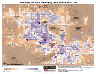
Walkability by Census Block Group in the Phoenix Metro Area
Walkability Score
Least Walkable Most Walkable
Ü0 3.5 71.75
Miles
Phoenix
Scottsdale
Mesa
Glendale
Tempe
Guadalupe
Fountain Hills
Litchfield Park
Surprise
Goodyear
Sun
City
Luke Air
Force
Base
Fort McDowell
Yavapai
Nation
Reservation
Chandler
Gilbert
Phoenix Sky
Harbor
Int'l Airport
Estrella
Mountain
Regional Park
Peoria
Paradise
Valley
Produced for WalkIT Arizona Study in May 2016
Authors: Marc Adams, Madison Davis, Parul Singh, Jane Hurley, Lu Hao
Scale:1:275,000
Service Layer Credits: Sources: Esri, USGS, NOAA
For more information:
§¨¦10
§¨¦17
UV143
UV303
UV101
UV202
£¤60
UV87
UV51
Phoenix
Mountains
£¤60
£¤60
UV101
UV101
§¨¦10
UV202
§¨¦10
§¨¦10
§¨¦17
UV202
£¤60
UV202
UV101
UV101
UV101
South Mountain
Park
McDowell
Mountains
§¨¦17
Phoenix
Sonoran Desert
Preserve
North
Mountain
UV87
Phoenix-Mesa
Gateway
Airport
Salt River
Salt River

Walkability Map

  • 1.
    Walkability by CensusBlock Group in the Phoenix Metro Area Walkability Score Least Walkable Most Walkable Ü0 3.5 71.75 Miles Phoenix Scottsdale Mesa Glendale Tempe Guadalupe Fountain Hills Litchfield Park Surprise Goodyear Sun City Luke Air Force Base Fort McDowell Yavapai Nation Reservation Chandler Gilbert Phoenix Sky Harbor Int'l Airport Estrella Mountain Regional Park Peoria Paradise Valley Produced for WalkIT Arizona Study in May 2016 Authors: Marc Adams, Madison Davis, Parul Singh, Jane Hurley, Lu Hao Scale:1:275,000 Service Layer Credits: Sources: Esri, USGS, NOAA For more information: §¨¦10 §¨¦17 UV143 UV303 UV101 UV202 £¤60 UV87 UV51 Phoenix Mountains £¤60 £¤60 UV101 UV101 §¨¦10 UV202 §¨¦10 §¨¦10 §¨¦17 UV202 £¤60 UV202 UV101 UV101 UV101 South Mountain Park McDowell Mountains §¨¦17 Phoenix Sonoran Desert Preserve North Mountain UV87 Phoenix-Mesa Gateway Airport Salt River Salt River