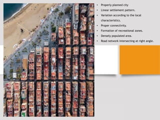
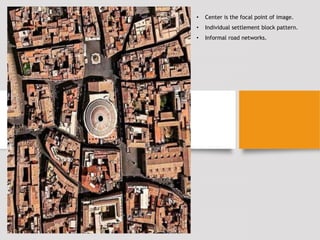
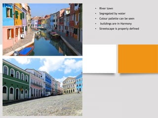
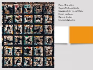
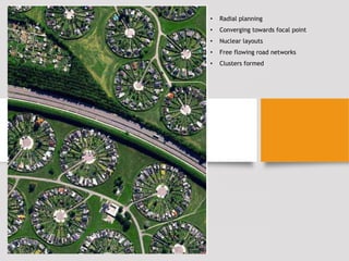
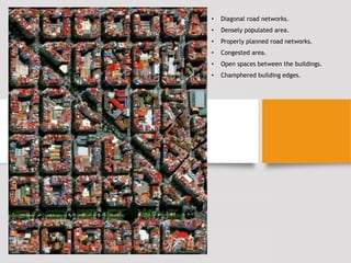
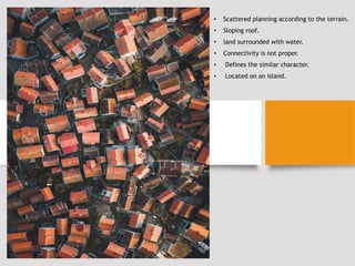
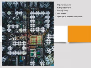
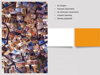
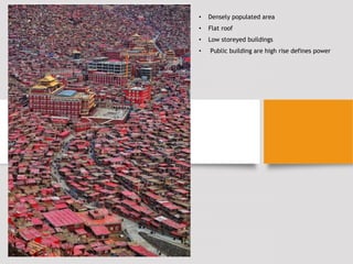
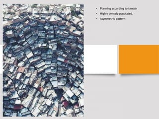
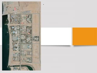
THEORY & METHODS IN URBAN DESIGN
ASSIGNMENT :1
PRESENTED BY : SALONI KHANDELWAL
F.Y. M.ARCH
• Properly planned city
• Linear settlement pattern.
• Variation according to the local
characteristics.
• Proper connectivity.
• Formation of recreational zones.
• Densely populated area.
• Road network intersecting at right angle.
• Center is the focal point of image.
• Individual settlement block pattern.
• Informal road networks.
• River town
• Segregated by water
• Colour pallette can be seen
• buildings are in Harmony
• Streetscape is properly defined
• Planned Grid pattern
• Cluster of individual blocks.
• Easy accessibility for each block.
• Densely populated.
• High rise structure
• Symmetrical planning
• Radial planning
• Converging towards focal point
• Nuclear layouts
• Free flowing road networks
• Clusters formed
• Diagonal road networks.
• Densely populated area.
• Properly planned road networks.
• Congested area.
• Open spaces between the buildings.
• Champhered building edges.
• Scattered planning according to the terrain.
• Sloping roof.
• land surrounded with water.
• Connectivity is not proper.
• Defines the similar character.
• Located on an island.
• High rise structure
• Metropolitian town
• Group planning
• Grid pattern
• Open spaces between each cluster
• No margins
• Improper placements
• No vechicular connectivity
• Compact planning
• Densely populated
• Densely populated area
• Flat roof
• Low storeyed buildings
• Public building are high rise defines power
• Planning according to terrain
• Highly densely populated.
• Asymmetric pattern
•

TMUD-SALONI KHANDELWAL.pptx

  • 1.
    THEORY & METHODSIN URBAN DESIGN ASSIGNMENT :1 PRESENTED BY : SALONI KHANDELWAL F.Y. M.ARCH
  • 2.
    • Properly plannedcity • Linear settlement pattern. • Variation according to the local characteristics. • Proper connectivity. • Formation of recreational zones. • Densely populated area. • Road network intersecting at right angle.
  • 3.
    • Center isthe focal point of image. • Individual settlement block pattern. • Informal road networks.
  • 4.
    • River town •Segregated by water • Colour pallette can be seen • buildings are in Harmony • Streetscape is properly defined
  • 5.
    • Planned Gridpattern • Cluster of individual blocks. • Easy accessibility for each block. • Densely populated. • High rise structure • Symmetrical planning
  • 6.
    • Radial planning •Converging towards focal point • Nuclear layouts • Free flowing road networks • Clusters formed
  • 7.
    • Diagonal roadnetworks. • Densely populated area. • Properly planned road networks. • Congested area. • Open spaces between the buildings. • Champhered building edges.
  • 8.
    • Scattered planningaccording to the terrain. • Sloping roof. • land surrounded with water. • Connectivity is not proper. • Defines the similar character. • Located on an island.
  • 9.
    • High risestructure • Metropolitian town • Group planning • Grid pattern • Open spaces between each cluster
  • 10.
    • No margins •Improper placements • No vechicular connectivity • Compact planning • Densely populated
  • 11.
    • Densely populatedarea • Flat roof • Low storeyed buildings • Public building are high rise defines power
  • 12.
    • Planning accordingto terrain • Highly densely populated. • Asymmetric pattern
  • 13.