Download to read offline

![© Dhani Irwanto 2025
4
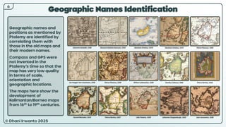
Geography of Taprobana
Borneo/
Kalimantan
Sulawesi
Java
Mindanao
© Dhani Irwanto 2025
Equator
Eratosthenes (ca 220
BCE):
• Located in Eastern sea,
lies extended opposite to
Greater India.
• 7,000 stadia (≈ 1,300 km)
in length, and 5,000
(≈ 925 km) in width.
Strabo (ca 25 BCE):
• Enjoying two summers
and two winters.
• 4 days’ sail to Coliacum
(Malaya Peninsula).
• Midway laid “the island
of the Sun [worshipper]”.
• Sea with greenish tint,
numerous trees [corals],
rudders broke off.
• Surrounding sea mostly
shallow.
Greenish tint,
numerous corals,
shallow sea](https://image.slidesharecdn.com/taprobana-250812022304-5144d73d/85/Taprobana-A-research-by-Dhani-Irwanto-5-320.jpg)
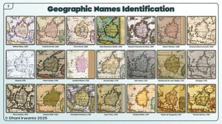
![© Dhani Irwanto 2025
5
Environment of Taprobana
Pliny (ca 50 CE):
• Local chief Rachia [Rajah
of the Dayaks].
• Port of Hippuri [Tanjung
Puri].
Ptolemy (ca 150 CE):
• Name altered to Salike
[Tanjung Salaka].
Periplus Maris Erythraei
(1st century CE):
• Name altered to
Palaesimundu.
• Azania [Kahayan] River
• Pearls, transparent
stones, muslins and
tortoise shell.
Cosmas Indicopleustes
(6th century CE):
• Known as Serendib
[Nusa Kencana, gold
island].
Borneo/
Kalimantan
Strabo (ca 25 BCE):
• 200,000 population.
• Palaesimundus
[Banjarmasin] was the
famous place.
• Prachii [Banjar] colonists
• A large lake [swamp]
called Megisba.
• 3 rivers, 5 – 15 stadia
[925 – 2775 m] wide,
northward.
• Corals, pearls, and
precious stones.
• Fruitful soil; fruits other
than vine; >100 years life.
• Chased tigers and
elephants, fished,
catched giant turtles.
• Maritime and highly
commercial.
• Traded with China.
• Carried birds [helmeted
hornbills] to navigate.
Palaesimundus
[Banjarmasin]
3 rivers
Lake [swamp]
Salike
[Tanjung Salaka]
Bornean
hornbill
Bornean
giant turtle
Bornean
tiger
Bornean
elephant
Corals, pearls,
gemstones, muslins,
tortoise shells
Gold island
Fruitful soil
Tigers, elephants,
fishes, giant turtles
Maritime and highly
commercial
Trade with China
Birds to navigate
Chief Rachia [Rajah]
Prachii [Banjar]
colonists
Bornean
gemstones](https://image.slidesharecdn.com/taprobana-250812022304-5144d73d/85/Taprobana-A-research-by-Dhani-Irwanto-6-320.jpg)
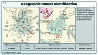
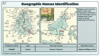
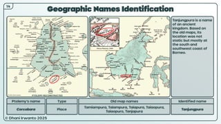
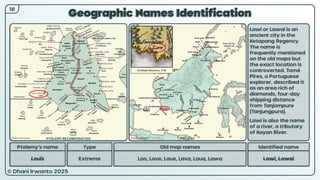
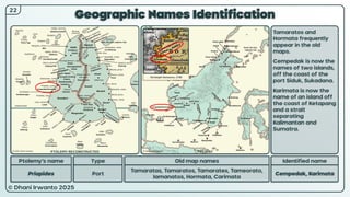
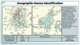
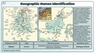
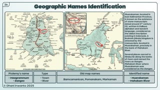
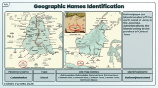
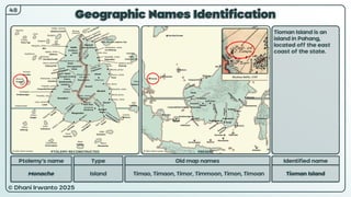
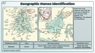
![© Dhani Irwanto 2025
Geographic Names Identification
Ptolemy’s name Type
• Soana
• Soani
• River
• Region
Old map names
Sonee, Senar, Soné, Sone, Sona, Soengi
Identified name
Sungai [Sambas],
Sungai [Kapuas]
The names are found
on 18th and 19th century
maps indicating the
three rivers around the
Main Sambas River,
literary mean “river”
(“sungai”).
These are written as
Sone Sambas, Sone
Luban and Sone
Nangor.
The “sungai” can also
mean Kapuas River. It
originates in the Müller
mountain range at the
center of the island
and flows west into
the South China Sea.
Ioachim Ottens, 1710
25
PTOLEMY RECONSTRUCTED PRESENT](https://image.slidesharecdn.com/taprobana-250812022304-5144d73d/85/Taprobana-A-research-by-Dhani-Irwanto-26-320.jpg)

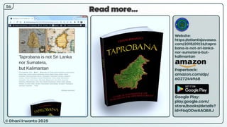
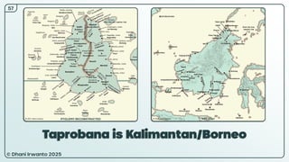

The mystery of Taprobana has captivated scholars and explorers for centuries. Often appearing on ancient maps as a prominent landmass in the Indian Ocean, Taprobana has been variously identified as Sri Lanka, Sumatra, and even Madagascar. Yet, these identifications have always left certain historical and geographical inconsistencies unresolved. This presentation is the culmination of years of research, beginning in 2015, dedicated to answering the question: What is the true identity of Taprobana? Drawing upon classical sources—including the works of Eratosthenes, Strabo, Pliny, and Ptolemy—this study undertakes a comprehensive analysis of ancient texts, old maps, geographic features, and local place names. The investigation meticulously correlates Ptolemy’s list of locations with modern maps, cross-examines ancient measurements and descriptions, and evaluates environmental, cultural, and economic clues. The findings presented here point unmistakably to Kalimantan, or Borneo, as the ancient Taprobana. Several compelling pieces of evidence support this conclusion: Borneo is the only large island in the region to straddle both sides of the equator—thus uniquely experiencing two summers and two winters as described in classical sources; the island’s size, shape, river systems, and biodiversity closely match the historical records; and the persistence of ancient names, places, and kingdoms further strengthens the identification. This work not only challenges long-held assumptions but also enriches our understanding of Southeast Asia’s place in world history. By reclaiming Kalimantan’s legacy as the fabled Taprobana, this research invites a re-examination of the maritime, cultural, and economic history of the region, and offers new perspectives on the movement of people, goods, and ideas across the ancient world.


