The document presents a study on a decentralized congestion control scheme in vehicular ad-hoc networks (VANETs) aimed at improving traffic management through real-time data communication. The proposed method utilizes a mobile app on drivers' smartphones to detect traffic congestion using GPS location, allowing for information dissemination via roadside units to guide approaching vehicles. The results show that the new methodology enhances coverage probability and could help mitigate traffic congestion effectively.
![International Journal of Trend in Scientific Research and Development (IJTSRD)
Volume 3 Issue 5, August 2019 Available Online: www.ijtsrd.com e-ISSN: 2456 – 6470
@ IJTSRD | Unique Paper ID – IJTSRD25324 | Volume – 3 | Issue – 5 | July - August 2019 Page 398
Study of Congestion Control Scheme with
Decentralized Threshold Function in VANETs
Anees Khan1, Prof. Sarwes Site2
1PG Scholar, 2Assistant Professor
1,2Department of CSE, All Saints College of Engineering, Bhopal, Madhya Pradesh, India
How to cite this paper: Anees Khan | Prof.
Sarwes Site "Study of Congestion Control
Scheme with Decentralized Threshold
Function in VANETs" Published in
International
Journal of Trend in
Scientific Research
and Development
(ijtsrd), ISSN: 2456-
6470, Volume-3 |
Issue-5, August
2019, pp.398-401,
https://doi.org/10.31142/ijtsrd25324
Copyright © 2019 by author(s) and
International Journalof Trendin Scientific
Research and Development Journal. This
is an Open Access article distributed
under the terms of
the Creative
CommonsAttribution
License (CC BY 4.0)
(http://creativecommons.org/licenses/by
/4.0)
ABSTRACT
With the constant increase in vehicular traffic, existing traffic management
solutions have become inefficient. Urbanization hasled to an increasein traffic
jams and accidents in major cities. In order to accommodate the growing
needs of transport systems today, there is a need for an Intelligent Transport
System. Vehicular Ad-hoc Network (VANET) is a growing technology that
assists in Intelligent Transport Systems. VANETs enable communication
between vehicles as well as fixed infrastructure called Road Side Units (RSU).
We propose a distributed, collaborative traffic congestion detection and
dissemination system that uses VANET. Each of the driver’s smart phones is
equipped with a Traffic App which is capable of location detection through
Geographic Position based System (GPS). This information is relayed to a
remote server which detects traffic congestion. Once congestion is confirmed
the congestion information is disseminated to the end user phone through
RSUs. The Mobile App transmits the location informationatperiodicintervals.
Using the latitude, longitude and the current time, the location of each vehicle
is traced. Using location information, the distance moved by the vehicle at a
given time is monitored. If the value is below a fixed threshold, congestion is
suspected in a particular area. If many vehicles in the same area send similar
messages, traffic congestion isconfirmed. Oncetrafficcongestion isconfirmed,
the vehicles approaching the congested area are informed about the traffic
through display boards that are available in the nearest RSUs (traffic signals).
The congestion information is also made available through the Mobile App
present in vehicles approaching the congested area. Theapproachingvehicles
may take diversion and alleviate congestion.
KEYWORDS: Vehicular Traffic, Intelligent Transport System, Road Side Units,
Geographic Position based System
1. INTRODUCTION
Transportation is an activity involving the movement of
people or goods from one place to another in order to meet
the perceived social and economic needs of a user. As these
needs change, the transportation system itself evolves and
problems occur as it becomes difficult to serve the public
interest. One of the negative impacts of any transportation
system is traffic congestion[1].Vehicular trafficcongestionis
a condition that occurs on roadnetworks,whichinvolves the
increased queuingof vehiclescharacterizedbyincreased trip
times and fuel consumption. Traffic congestion occurs
wherever demand exceedsthecapacityof thetransportation
system and the most common problem is queuing up of
vehicles near toll booths [2]. Vehicular traffic can be
witnessed mainly on highways and major roadsthatconnect
industries. Metropolitan and cosmopolitan cities are found
to have higher traffic congestion than other parts. Vehicular
traffic congestion poses numerous threats and arises
numerous problems to the vehicle drivers. Various
industries that bank on freight transport lose a heavysumof
money annually due to traffic congestion. Various
institutions, government bodies and organizations have
undertaken surveys and studies to understand the causes
and consequences of vehicular traffic congestion and also to
provide efficient solutions toavoidtrafficcongestion. VANET
also helps us to achieve car to car communications and
perform simulations at a relatively low cost [3]. Recent
efforts have placed a strong emphasis on VANET design
implementations [4].
Thus a smart traffic congestion detection and dissemination
system is developed to divert incoming vehicles and reduce
congestion without human intervention. This system can be
further enhanced by communicating the congestion
information directly between vehicles using IEEE 802.11p
protocol.
2. NEED FOR TRAFFIC CONGESTION
MANAGEMENT
The steady population increase in urban areas has led to an
exponential increase in the number of vehicles on road.
Vehicular traffic is one of the most important social and
economic issues faced today resulting in congestion. With
tremendous growth in industries, the need to reach the
destination within a certain time is on-demand. Problem
occurs when important destinations lie on the same route. A
single technology park housing multiple companies with
each company accommodating more than a hundred
employees is one such example. In these cases, traffic
IJTSRD25324](https://image.slidesharecdn.com/68studyofcongestioncontrolschemewithdecentralizedthresholdfunctioninvanets-190907072216/75/Study-of-Congestion-Control-Scheme-with-Decentralized-Threshold-Function-in-VANETs-1-2048.jpg)
![International Journal of Trend in Scientific Research and Development (IJTSRD) @ www.ijtsrd.com eISSN: 2456-6470
@ IJTSRD | Unique Paper ID – IJTSRD25324 | Volume – 3 | Issue – 5 | July - August 2019 Page 399
becomes unavoidable and there is a need for a solution to
avoid vehicular traffic congestion.
A smart transport system which will provide real time
information about the traffic by p2p [5] is the need of the
hour. The existing smart transport systems demand a need
for the construction of expensive infrastructuresor achange
in the road structure. Although these systems prove to be
very effective, they will consume enormous amount of time
and cost to be deployed.
Nowadays, the roads within cities are well-connected and
therefore there are numerous routesforasingledestination.
If one route is congested, an alternate route can be taken. A
simple solution to traffic congestion is to gain knowledge
about the traffic congested routes. Once this knowledge is
gained, it is feasible to identify an alternate path and divert
from traffic congested areas. This solution not only helps in
vehicle diversion but also resolves traffic congestion at a
minimal time.
3. PROPOSED METHODOLOGY
The main goal of the proposed method Improved
Decentralized Congestion Control with Carrier Sensing
Threshold (IDCCCST) is to ease the channel load, so that
safety data traffic can be served on time. It is a cross-layer
solution because based on channel state information
(acquired using channel probing) PHY layer parameters are
set in order to enhance the IEEE 802.11p MAC performance.
3.2.1. ALGORITHM
The algorithm of proposed methodology improved
decentralized congestion control with carrier sensing
threshold (IDCCCST) is performs in two phases as follows:
Phase I: Determine channel load being congested.
Input: A set of nodes N = {u1, u2,....,un}
Output: The aggregated channel load Lr+1
Begin
{
for (ui∈ N)
{
Li = Channel_monitoring(p, r, ρ );
Li+1 = Objective_load(Lr-1,Lr,Lr+1);
}
Channel_monitoring(constra int p, constra int r, constra
int ρ )
{
. . . .i
p
L C r
n
ρ τ= ; // the channel load at t=iT
return Li;
}
Objective_load(constra int Lr-1, constra int Lr, constra int
Lr+1)
{
( )1 11r r rL L Lα α+ −= + − ; // the channel load at t=iT
return Li;
}
}
End
Phase 2: Resolve congestion case.
Input: Channel load
Output: Congestion free network
Begin
If(channel_load>fixed_congestion_free_load)
{
In congested area, every node broadcast messages to all
neighbors;
Determine affected vehicle in congestion area on the basis
of update flag_count;
When affected vehicle is found then it is isolated from
congested area;
Isolated node is distributing channel_load in congested
area;
Isolated node maintains traffic with carrier sense
threshold;
}
Else
Print “Congestion free VANET”;
End
3.2.2. FLOWCHART
The flowchart of proposed methodology improved
decentralized congestion control with carrier sensing
threshold (IDCCCST) is performs as follows:
Figure 1: Flowchart of proposed work (IDCCCST)
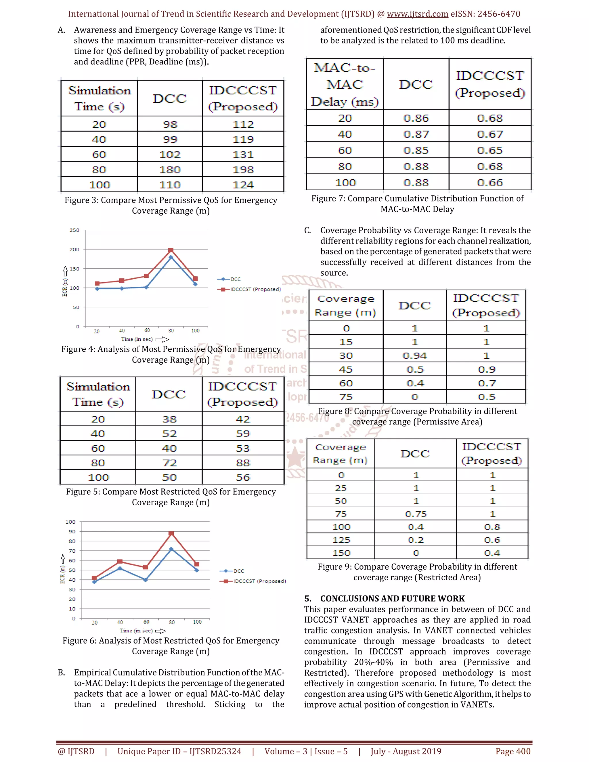
4. RESULT ANALYSIS
The implementation work performs on MATLAB R2013a. It
shows simulation results of an individual node during the
merging of two VANETs. In figure2,thedynamicevolution of
the simulated scenario is depicted. Thesituation displayed is
the merging situation in the time instant t=100s. The
performance indicators under study are:
Figure 2: Simulation of Congestion Control in VANETs](https://image.slidesharecdn.com/68studyofcongestioncontrolschemewithdecentralizedthresholdfunctioninvanets-190907072216/75/Study-of-Congestion-Control-Scheme-with-Decentralized-Threshold-Function-in-VANETs-2-2048.jpg)
![International Journal of Trend in Scientific Research and Development (IJTSRD) @ www.ijtsrd.com eISSN: 2456-6470
@ IJTSRD | Unique Paper ID – IJTSRD25324 | Volume – 3 | Issue – 5 | July - August 2019 Page 401
6. REFERENCES
[1] Lecture notes in Traffic Engineering And Management
by Civil department, IITB.
[2] Robinson, R. "Problems in the urban environment:
traffic congestion and its effects." Wollongong Studies
in Geography (1984): 14.
[3] Mittal, Narendra Mohan, and Savita Choudhary.
"Comparative Study of SimulatorsforVehicularAd-hoc
Networks (VANETs)." International Journal of
Emerging Technology and Advanced Engineering
Website: www. ijetae. com (ISSN2250-2459, ISO9001:
2008 Certified Journal, Volume 4, Issue 4(2014).
[4] Zeadally, Sherali, Ray Hunt, Yuh-Shyan Chen, Angela
Irwin, and Aamir Hassan. "Vehicular ad hoc networks
(VANETS): status, results, and challenges."
Telecommunication Systems 50, no.4 (2012):217-241.
[5] El-Sersy, Heba, and Ayman El-Sayed. "Survey of Traffic
Congestion Detection using VANET."
[6] Zeadally, S., Hunt, R., Chen, Y. S., Irwin, A., & Hassan, A.
(2012). Vehicular ad hoc networks (VANETS): status,
results, and challenges. Telecommunication Systems,
50(4), 217-241.
[7] Teixeira, Fernando A., et al. "Vehicular networks using
the IEEE 802.11 p standard: an experimentalanalysis."
Vehicular Communications 1.2 (2014): 91- 96.
[8] Kausar, Tanwee, Priyanka Gupta, Deepesh Arora, and
Rishabh Kumar. "A VANET based CooperativeCollision
Avoidance System for a 4-Lane Highway."
[9] Akhtar, Naheed, Sinem Coleri Ergen, and Oznur
Ozkasap. "Vehiclemobility and communication channel
models for realistic and efficient highway VANET
simulation." Vehicular Technology, IEEE Transactions
on 64.1 (2015): 248-262.
[10] Cavalcante, Evellyn S., André LL Aquino, Gisele L.
Pappa, and Antonio AF Loureiro. "Roadside unit
deployment for information dissemination in aVANET:
An evolutionary approach." In Proceedings of the 14th
annual conference companion on Genetic and
evolutionary computation, pp. 27-34. ACM, 2012.
[11] Gamati, Emadeddin A., Richard Germon, and Evtim
Peytchev. "Collaborative Data Dissemination Methods
In VANETs For Identifying Road Conditions Zone
Boundaries." In ECMS, pp. 372-378. 2013.
[12] Kausar, Tanwee, Priyanka Gupta, Deepesh Arora, and
Rishabh Kumar. "A VANET basedCooperativeCollision
Avoidance System for a 4- Lane Highway."
[13] Wang, Miao, et al. "Real-time path planning based on
hybrid-VANET-enhanced transportation system."
Vehicular Technology, IEEE Transactions on 64.5
(2015): 1664-1678.
[14] He, Zongjian, Buyang Cao, and Yan Liu. "Accurate Real-
Time Traffic Speed Estimation Using Infrastructure-
Free Vehicular Networks." International Journal of
Distributed Sensor Networks 2015 (2015).](https://image.slidesharecdn.com/68studyofcongestioncontrolschemewithdecentralizedthresholdfunctioninvanets-190907072216/75/Study-of-Congestion-Control-Scheme-with-Decentralized-Threshold-Function-in-VANETs-4-2048.jpg)


