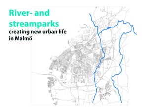
2. DNA walk of Malmö-
a dynamic penetration opf the landscape Rivers and streams
penetrating the landscape
Ris
eb
erg
Se
ge
ab
å
äck
n e
d
en
ns
w
To
the definite border of
Malmö
3. Fosie/Fredriksberg
industriområde
this industrial/business sone
represents an inbetween
land surrounded by heavy
infrastructure. The urban
Malmö facing it from north-
west and rural Skåne in the
east/southeast.
The stream Risebergabäcken
cuts through regardless of
new regulations and human
activity
Fosie
Fredriksberg
Risebergabäcken
4. Infrastructure
The main roads encircling Husie
and Fredriksberg industrial area
clearly defines its borders.
Yst
adv
With the introduction of the In- 4) äg
97 en
(1
ner ringroad Husie was opened ad
ngro
up for industrial purposes. e r ri
Inn
The Outer ringroad defined a
demarktionline for suburban
development.
)
00
d (20
roa
ri ng
ter
Ou
5. Industry/business
The industrial plots occupies large
amounts of land, however the build-
ings themselves take up relatively little
space. This could open for more
diverse use of available soil.
6. Undefined green area/
nature
Green areas and the stream
Risebergabäcken presents
potetial for establishing areas of
food production - food forrests/
permaculture.
Such a landscape can help fight
erosion and flooding. Further they
can assist in harvesting rainwater
as a resource.
7. Farmed land
Although some plots with farmed
land still remain within the
industrial area there is a clear
frontier of Skåne`s
rural farmland on the “out-
side” of The outer Ringroad.
View from rural Skåne across the Outer
Ringroad towards “the edge of town”
8. Identity
some of the characteristics
of the area
Newly developed
office/cardealerships
Dwellings
Fredriksbergs gård
Big scale businesses/
industry
Small scale businesses/
industry
Allotments
Prison
Örestads
ryttarforening
Schools
9. Schools as knowledge
base for the population
Making use of schools located in
the area one can create an arene
for educating the population on
new ways of thinking urban life;
e.g. food production and wildlife
10. Nature at risk
Risebergabäcken is an intact natural element cut-
ting
through the industrial area of Fosie/Fredriksberg.
Hard surfaces and monotonous agricultural land-
scape causes exess water to flood the stream in
heavy rain.
11. Water source
this map shows the watercollection area of
Risebergabäcken
Running trough hard urban surfaces and agricultur-
al land there is a need for creating more absorbing
and permeable sones along the stream
12. Stream park
Having Risebergabäcken as a point of departure
I see the potential in creating a park/green sone along
the stream.
This could set the premises for further development of
the Fosie/Fredriksberg industrial area.
Ultimately making the place more diverse;
green structures, business, dwellings, food production