SPECIFIC GRAVITY OFROCKS
The specific gravity of rock varies depending on its composition, but it generally falls within the range of 2.0
to 3.0. For example, granite and rhyolite typically have specific gravities between 2.4 and 2.8, while basalt
and dolerite range from 2.8 to 3.0. Sedimentary rocks have a wider range, often between 2.4 and 2.8,
depending on factors like composition and porosity.
• What is specific gravity?
Specific gravity is the ratio of a rock's density to the density of water. Since the density of water is 1 gram per
cubic centimetre, the specific gravity of a rock is numerically equal to its density in grams per cubic
centimetre.
• Why does it vary?
Different rocks are composed of different minerals, each with its own specific gravity. For instance, quartz
has a specific gravity of 2.65, while metallic minerals like galena can have much higher specific gravities
(e.g., 7.5).
• Examples:
• Granite: 2.6-2.7
• Basalt: 2.8-3.0
• Limestone: 2.3-2.7
• Importance:
Specific gravity is a useful property for identifying rocks and minerals, as well as understanding their
behaviour in various applications, such as construction and engineering. For example, it can help determine
how suitable a rock is for use as a building stone, or how it might behave in soil or under pressure.
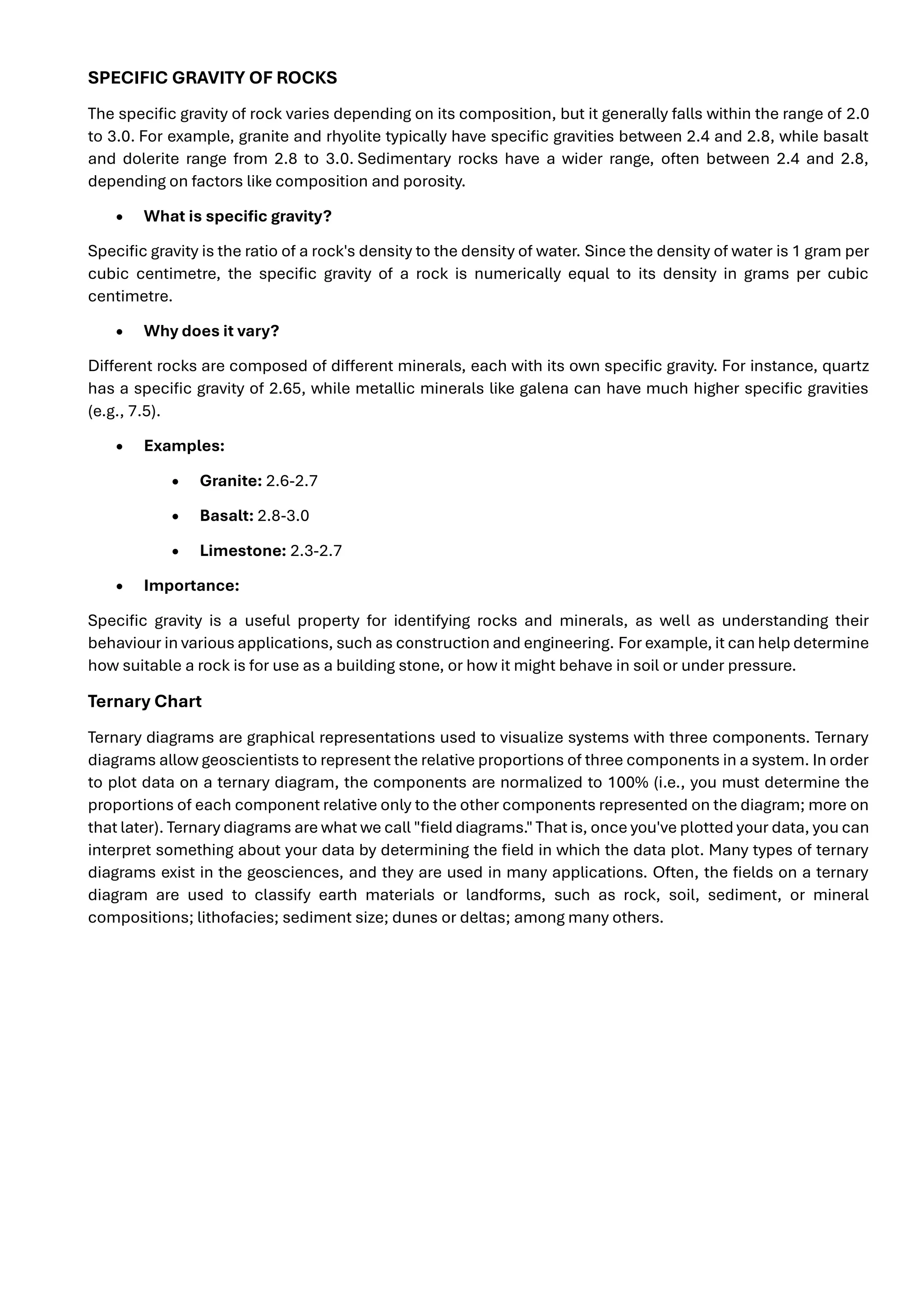
Ternary Chart
Ternary diagrams are graphical representations used to visualize systems with three components. Ternary
diagrams allow geoscientists to represent the relative proportions of three components in a system. In order
to plot data on a ternary diagram, the components are normalized to 100% (i.e., you must determine the
proportions of each component relative only to the other components represented on the diagram; more on
that later). Ternary diagrams are what we call "field diagrams." That is, once you've plotted your data, you can
interpret something about your data by determining the field in which the data plot. Many types of ternary
diagrams exist in the geosciences, and they are used in many applications. Often, the fields on a ternary
diagram are used to classify earth materials or landforms, such as rock, soil, sediment, or mineral
compositions; lithofacies; sediment size; dunes or deltas; among many others.
2.
A ternary chart,also known as a ternary diagram, triangular diagram, or simplex plot, is a graphical tool used
to represent the relative proportions of three components within a system. It's visually depicted as an
equilateral triangle, where each corner represents 100% of one component, and the sides represent binary
mixtures of the remaining two components. Ternary charts are commonly used in fields like geology,
chemistry, and materials science to analyze and visualize compositional data.
Here's a more detailed explanation:
Key Features:
• Three Components:
The chart displays the proportions of three variables that sum to a constant, typically 100%.
• Equilateral Triangle:
The data is plotted within an equilateral triangle, with each corner representing a pure component.
• Barycentric Coordinates:
The positions within the triangle are determined by barycentric coordinates, which represent the ratios of
the three components.
• Lines of Constant Composition:
Lines parallel to the sides of the triangle indicate constant percentages of a specific component.
How to Use a Ternary Chart:
1. 1. Identify the Components:
Determine the three variables you want to analyse.
2. 2. Normalize Data:
Ensure that the data for each component is expressed as a percentage or proportion (e.g., weight
percentage, mole percentage) that sums to 100%.
3. 3. Locate Points:
3.
Plot the datapoints on the triangle based on the normalized values of the three components.
4. 4. Interpret Results:
Analyse the distribution of points to understand the relationships and trends between the three
components.
Applications:
• Phase Diagrams:
Ternary phase diagrams show the relationships between different phases (solid, liquid, gas) in a three-
component system at various temperatures and pressures.
• Petrology:
Ternary diagrams are used to classify and analyze the composition of rocks and minerals.
• Materials Science:
They help in understanding the properties and behavior of materials with three constituent elements.
• Population Genetics:
In population genetics, ternary plots can be used to visualize genotype frequencies.
• Game Theory and Convex Optimization:
In these fields, ternary plots are also known as simplex plots.
Example:
In a ternary plot for a three-component soil (e.g., sand, silt, and clay), each corner of the triangle would
represent 100% of one component, and points within the triangle would represent different soil
compositions based on the proportions of sand, silt, and clay.
Magmas and Lava
Since volcanic eruptions are caused by magma (a mixture of liquid rock, crystals, and dissolved
gas) expelled onto the Earth's surface, we'll first review the characteristics of magma that we
covered previously.
Three basic types of magma:
1. Mafic or Basaltic-- SiO2 45-55 wt%, high in Fe, Mg, Ca, low in K, Na
2. Intermediate or Andesitic-- SiO2 55-65 wt%, intermediate. in Fe, Mg, Ca, Na, K
3. Felsic or Rhyolitic-- SiO2 65-75%, low in Fe, Mg, Ca, high in K, Na.
Gases - At depth in the Earth nearly all magmas contain gas. Gas gives magmas their explosive
character, because the gas expands as pressure is reduced.
• Mostly H2O with some CO2
• Minor amounts of Sulfur, Cl , and F
• Felsic magmas usually have higher gas contents than mafic magmas.
4.
Temperature of Magmas
•Mafic/Basaltic - 1000-1200o
C
• Intermediate/Andesitic - 800-1000o
C
• Felsic/Rhyolitic - 650-800o
C.
Viscosity of Magmas
Viscosity is the resistance to flow (opposite of fluidity). Depends on composition, temperature, &
gas content.
• Higher SiO2 content magmas have higher viscosity than lower SiO2 content magmas
• Lower Temperature magmas have higher viscosity than higher temperature magmas.
Thus, basaltic magmas tend to be fairly fluid (low viscosity), but their viscosity is still 10,000 to
100,0000 times more viscous than water. Rhyolitic magmas tend to have even higher viscosity,
ranging between 1 million and 100 million times more viscous than water. (Note that solids, even
though they appear solid have a viscosity, but it very high, measured as trillions time the viscosity
of water). Viscosity is an important property in determining the eruptive behaviour of magmas.
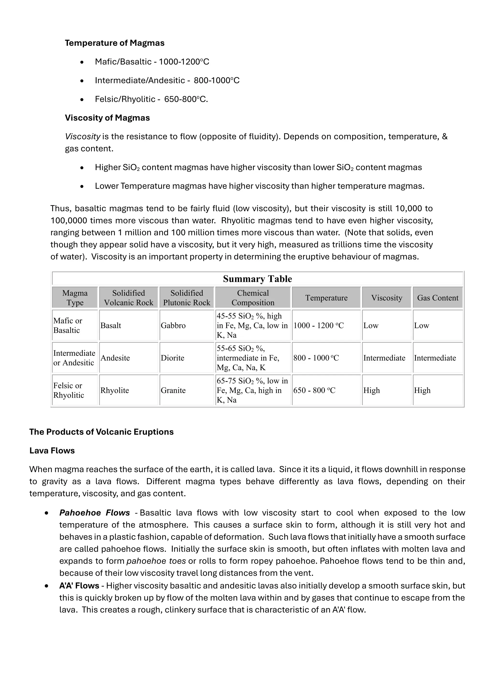
Summary Table
Magma
Type
Solidified
Volcanic Rock
Solidified
Plutonic Rock
Chemical
Composition
Temperature Viscosity Gas Content
Mafic or
Basaltic
Basalt Gabbro
45-55 SiO2 %, high
in Fe, Mg, Ca, low in
K, Na
1000 - 1200 o
C Low Low
Intermediate
or Andesitic
Andesite Diorite
55-65 SiO2 %,
intermediate in Fe,
Mg, Ca, Na, K
800 - 1000 o
C Intermediate Intermediate
Felsic or
Rhyolitic
Rhyolite Granite
65-75 SiO2 %, low in
Fe, Mg, Ca, high in
K, Na
650 - 800 o
C High High
The Products of Volcanic Eruptions
Lava Flows
When magma reaches the surface of the earth, it is called lava. Since it its a liquid, it flows downhill in response
to gravity as a lava flows. Different magma types behave differently as lava flows, depending on their
temperature, viscosity, and gas content.
• Pahoehoe Flows - Basaltic lava flows with low viscosity start to cool when exposed to the low
temperature of the atmosphere. This causes a surface skin to form, although it is still very hot and
behaves in a plastic fashion, capable of deformation. Such lava flows that initially have a smooth surface
are called pahoehoe flows. Initially the surface skin is smooth, but often inflates with molten lava and
expands to form pahoehoe toes or rolls to form ropey pahoehoe. Pahoehoe flows tend to be thin and,
because of their low viscosity travel long distances from the vent.
• A'A' Flows - Higher viscosity basaltic and andesitic lavas also initially develop a smooth surface skin, but
this is quickly broken up by flow of the molten lava within and by gases that continue to escape from the
lava. This creates a rough, clinkery surface that is characteristic of an A'A' flow.
5.
• Lava Tubes- Once the surface skin becomes solid, the lava can continue to flow beneath the surface in
lava tubes. The surface skin insulates the hot liquid lava form further cooling. When the eruption ends,
liquid lava often drains leaving an open cave.
• Pillow Lavas - When lava erupts on the sea floor or other body of water, the surface skin forms rapidly,
and, like with pahoehoe toes inflates with molten lava. Eventually these inflated balloons of magma drop
off and stack up like a pile of pillows and are called pillow lavas. Ancient pillow lavas are readily
recognizable because of their shape, their glassy margins and radial fractures that formed during cooling
• Columnar Jointing - When thick basaltic or andesitic lavas cool, they contract. The contraction results
in fractures and often times results in a type of jointing called columnar jointing. The columns are usually
hexagonal in shape. This often happens when lavas pool in depressions or deep canyons
• Siliceous Lava Flows - High viscosity andesitic and rhyolitic lava flows, because they can’t flow very
easily, form thick stubby flows that don’t move far from the vent.
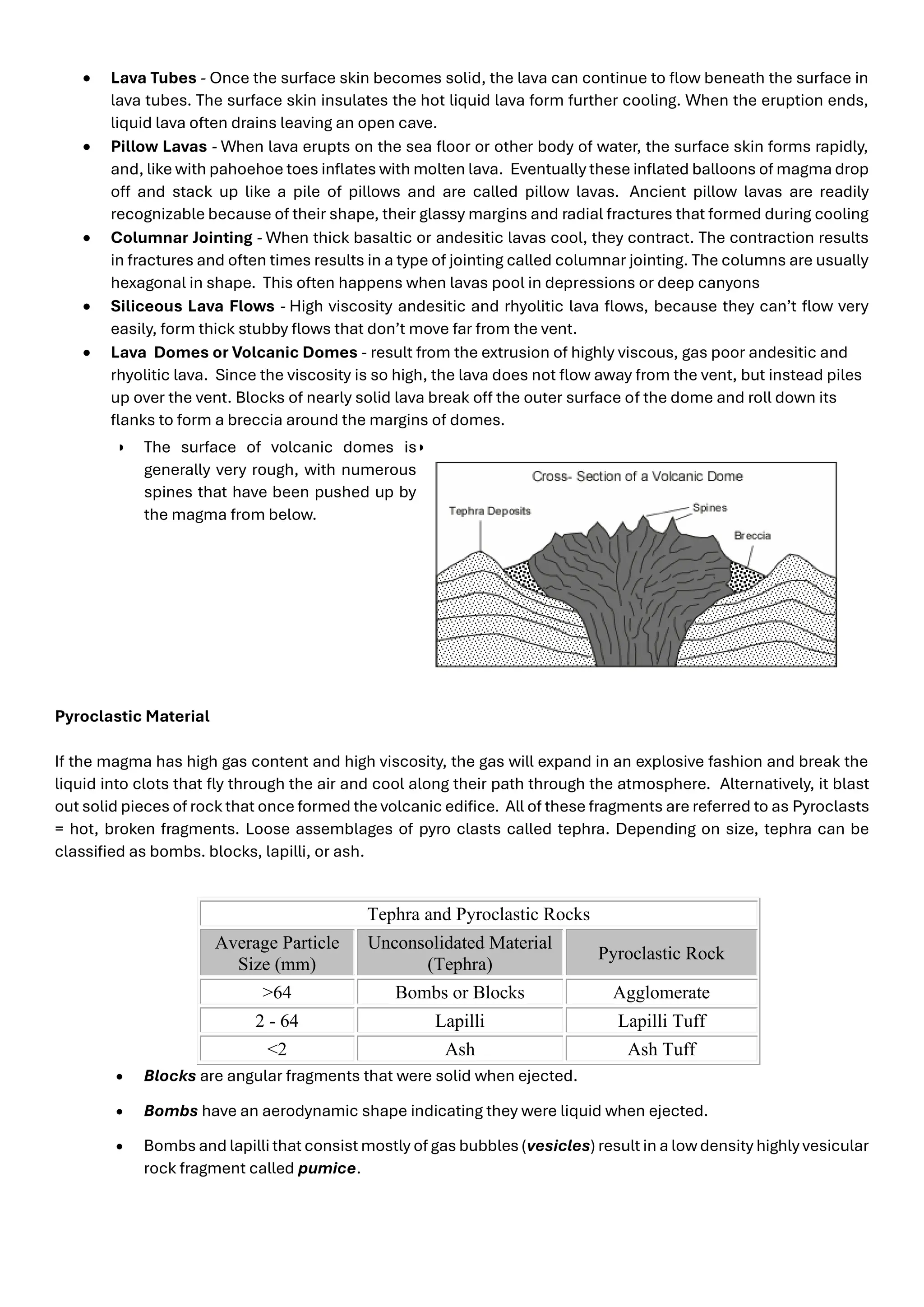
• Lava Domes or Volcanic Domes - result from the extrusion of highly viscous, gas poor andesitic and
rhyolitic lava. Since the viscosity is so high, the lava does not flow away from the vent, but instead piles
up over the vent. Blocks of nearly solid lava break off the outer surface of the dome and roll down its
flanks to form a breccia around the margins of domes.
• The surface of volcanic domes is
generally very rough, with numerous
spines that have been pushed up by
the magma from below.
•
Pyroclastic Material
If the magma has high gas content and high viscosity, the gas will expand in an explosive fashion and break the
liquid into clots that fly through the air and cool along their path through the atmosphere. Alternatively, it blast
out solid pieces of rock that once formed the volcanic edifice. All of these fragments are referred to as Pyroclasts
= hot, broken fragments. Loose assemblages of pyro clasts called tephra. Depending on size, tephra can be
classified as bombs. blocks, lapilli, or ash.
Tephra and Pyroclastic Rocks
Average Particle
Size (mm)
Unconsolidated Material
(Tephra)
Pyroclastic Rock
>64 Bombs or Blocks Agglomerate
2 - 64 Lapilli Lapilli Tuff
<2 Ash Ash Tuff
• Blocks are angular fragments that were solid when ejected.
• Bombs have an aerodynamic shape indicating they were liquid when ejected.
• Bombs and lapilli that consist mostly of gas bubbles (vesicles) result in a lowdensity highly vesicular
rock fragment called pumice.
6.
Rock formed byaccumulation and cementation of tephra called a pyroclastic rock or tuff. Welding, compaction
and deposition of other grains cause tephra (loose material) to be converted into pyroclastic rock.
Volcanic Landforms
Volcanic landforms are controlled by the geological processes that form them and act on them after they have
formed. Thus, a given volcanic landform will be characteristic of the types of material it is made of, which in turn
depends on the prior eruptive behaviour of the volcano. Here we discuss the major volcanic landforms and how
they are formed Most of this material will be discussed with reference to slides shown in class that illustrate the
essential features of each volcanic landform.
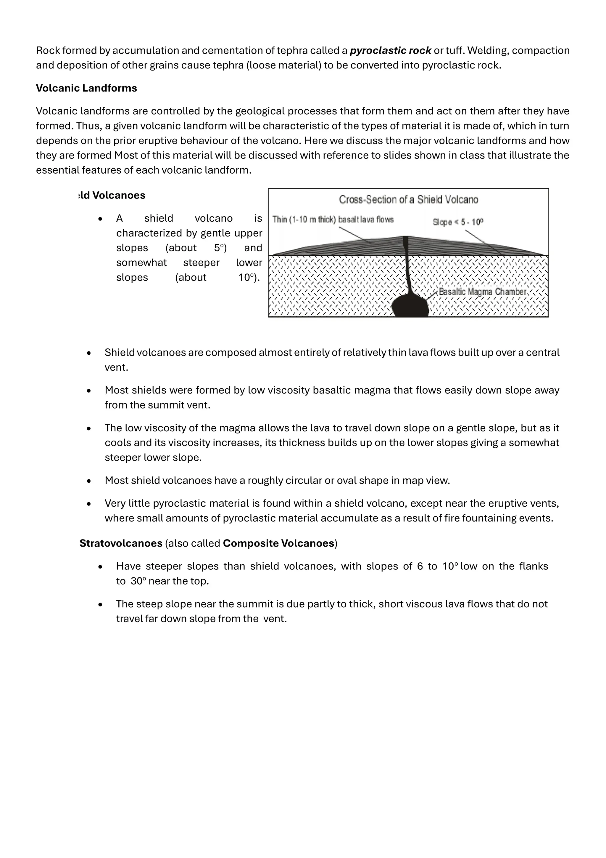
Shield Volcanoes
• A shield volcano is
characterized by gentle upper
slopes (about 5o
) and
somewhat steeper lower
slopes (about 10o
).
• Shield volcanoes are composed almost entirely of relatively thin lava flows built up over a central
vent.
• Most shields were formed by low viscosity basaltic magma that flows easily down slope away
from the summit vent.
• The low viscosity of the magma allows the lava to travel down slope on a gentle slope, but as it
cools and its viscosity increases, its thickness builds up on the lower slopes giving a somewhat
steeper lower slope.
• Most shield volcanoes have a roughly circular or oval shape in map view.
• Very little pyroclastic material is found within a shield volcano, except near the eruptive vents,
where small amounts of pyroclastic material accumulate as a result of fire fountaining events.
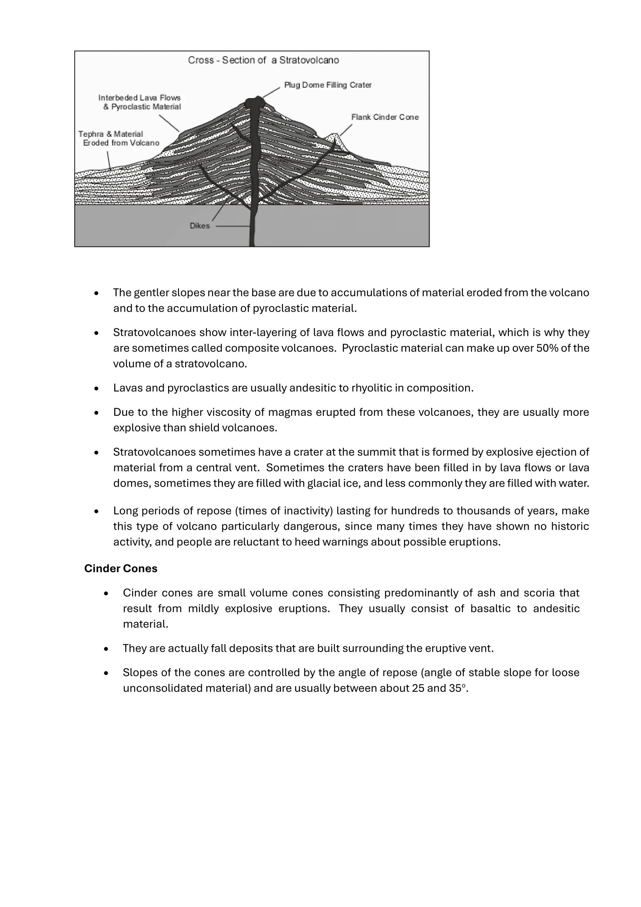
Stratovolcanoes (also called Composite Volcanoes)
• Have steeper slopes than shield volcanoes, with slopes of 6 to 10o
low on the flanks
to 30o
near the top.
• The steep slope near the summit is due partly to thick, short viscous lava flows that do not
travel far down slope from the vent.
7.
• The gentlerslopes near the base are due to accumulations of material eroded from the volcano
and to the accumulation of pyroclastic material.
• Stratovolcanoes show inter-layering of lava flows and pyroclastic material, which is why they
are sometimes called composite volcanoes. Pyroclastic material can make up over 50% of the
volume of a stratovolcano.
• Lavas and pyroclastics are usually andesitic to rhyolitic in composition.
• Due to the higher viscosity of magmas erupted from these volcanoes, they are usually more
explosive than shield volcanoes.
• Stratovolcanoes sometimes have a crater at the summit that is formed by explosive ejection of
material from a central vent. Sometimes the craters have been filled in by lava flows or lava
domes, sometimes they are filled with glacial ice, and less commonly they are filled with water.
• Long periods of repose (times of inactivity) lasting for hundreds to thousands of years, make
this type of volcano particularly dangerous, since many times they have shown no historic
activity, and people are reluctant to heed warnings about possible eruptions.
Cinder Cones
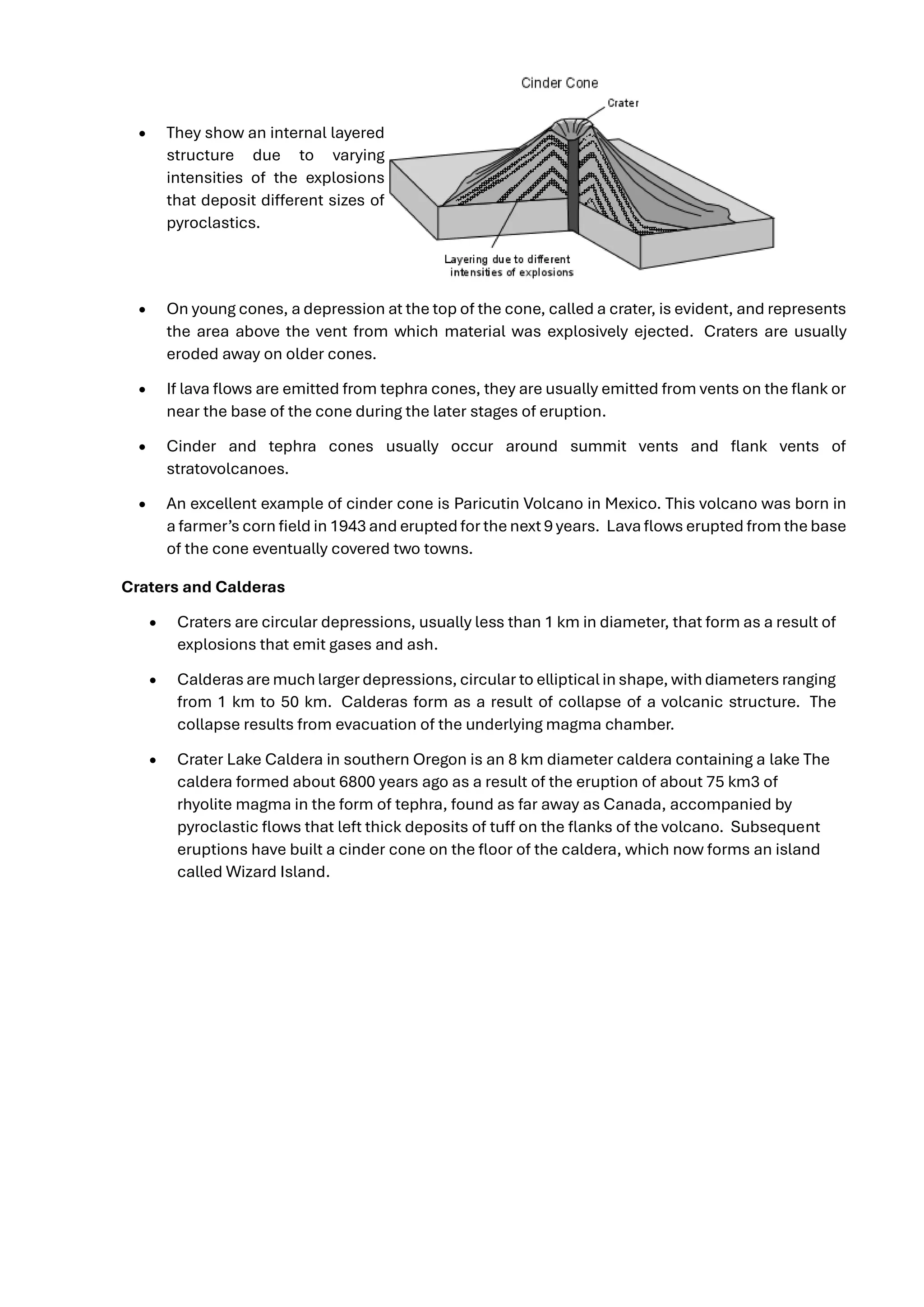
• Cinder cones are small volume cones consisting predominantly of ash and scoria that
result from mildly explosive eruptions. They usually consist of basaltic to andesitic
material.
• They are actually fall deposits that are built surrounding the eruptive vent.
• Slopes of the cones are controlled by the angle of repose (angle of stable slope for loose
unconsolidated material) and are usually between about 25 and 35o
.
8.
• They showan internal layered
structure due to varying
intensities of the explosions
that deposit different sizes of
pyroclastics.
• On young cones, a depression at the top of the cone, called a crater, is evident, and represents
the area above the vent from which material was explosively ejected. Craters are usually
eroded away on older cones.
• If lava flows are emitted from tephra cones, they are usually emitted from vents on the flank or
near the base of the cone during the later stages of eruption.
• Cinder and tephra cones usually occur around summit vents and flank vents of
stratovolcanoes.
• An excellent example of cinder cone is Paricutin Volcano in Mexico. This volcano was born in
a farmer’s corn field in 1943 and erupted for the next 9 years. Lava flows erupted from the base
of the cone eventually covered two towns.
Craters and Calderas
• Craters are circular depressions, usually less than 1 km in diameter, that form as a result of
explosions that emit gases and ash.
• Calderas are much larger depressions, circular to elliptical in shape, with diameters ranging
from 1 km to 50 km. Calderas form as a result of collapse of a volcanic structure. The
collapse results from evacuation of the underlying magma chamber.
• Crater Lake Caldera in southern Oregon is an 8 km diameter caldera containing a lake The
caldera formed about 6800 years ago as a result of the eruption of about 75 km3 of
rhyolite magma in the form of tephra, found as far away as Canada, accompanied by
pyroclastic flows that left thick deposits of tuff on the flanks of the volcano. Subsequent
eruptions have built a cinder cone on the floor of the caldera, which now forms an island
called Wizard Island.
9.
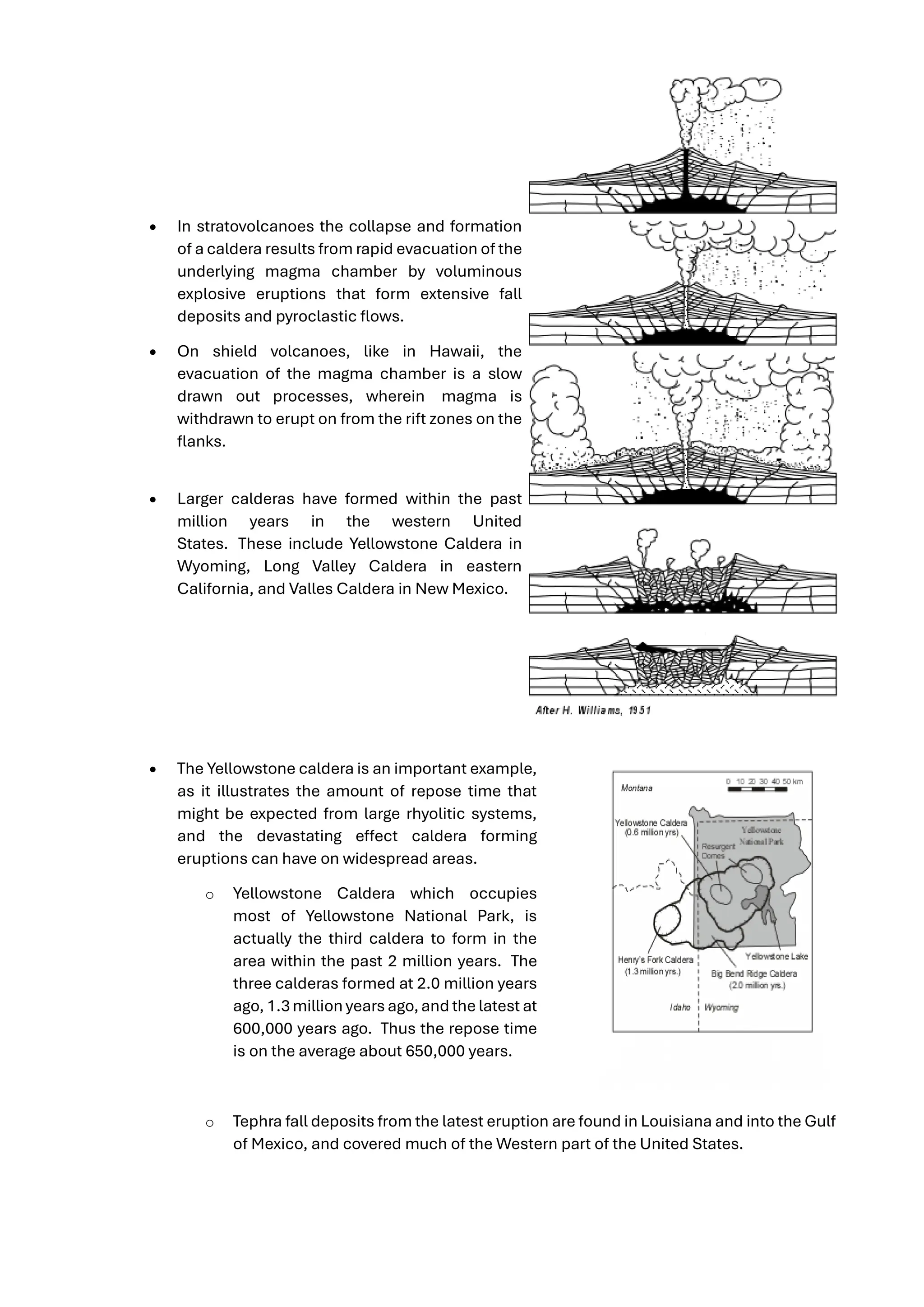
• In stratovolcanoesthe collapse and formation
of a caldera results from rapid evacuation of the
underlying magma chamber by voluminous
explosive eruptions that form extensive fall
deposits and pyroclastic flows.
• On shield volcanoes, like in Hawaii, the
evacuation of the magma chamber is a slow
drawn out processes, wherein magma is
withdrawn to erupt on from the rift zones on the
flanks.
• Larger calderas have formed within the past
million years in the western United
States. These include Yellowstone Caldera in
Wyoming, Long Valley Caldera in eastern
California, and Valles Caldera in New Mexico.
• The Yellowstone caldera is an important example,
as it illustrates the amount of repose time that
might be expected from large rhyolitic systems,
and the devastating effect caldera forming
eruptions can have on widespread areas.
o Yellowstone Caldera which occupies
most of Yellowstone National Park, is
actually the third caldera to form in the
area within the past 2 million years. The
three calderas formed at 2.0 million years
ago, 1.3 million years ago,and the latest at
600,000 years ago. Thus the repose time
is on the average about 650,000 years.
o Tephra fall deposits from the latest eruption are found in Louisiana and into the Gulf
of Mexico, and covered much of the Western part of the United States.
10.
o The eruption600,000 years ago produced about 1000 km3
of rhyolite (in
comparison, the eruption of Mt. St. Helens in May of 1980 produced only 0.75 km3
.
o Magma still underlies Yellowstone caldera, as evidenced by the large number of hot
springs and geysers in the area.
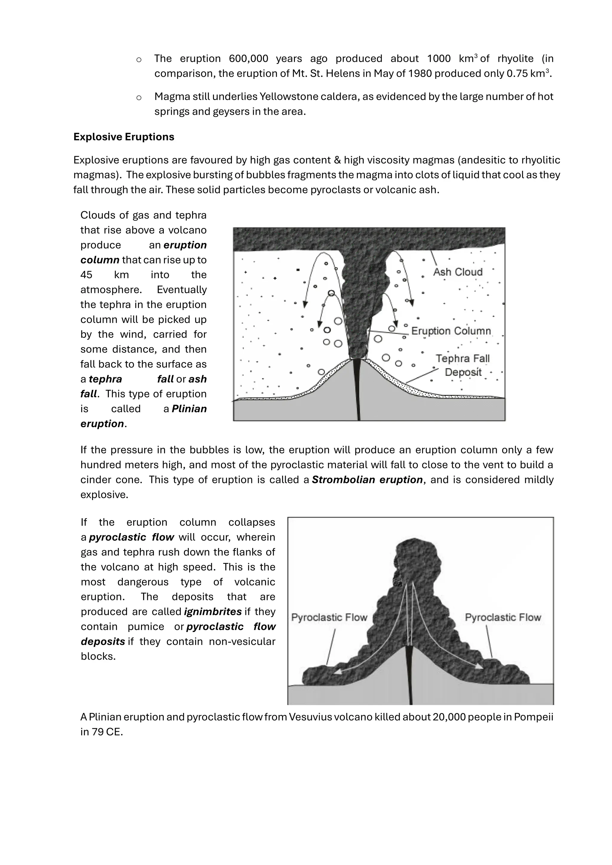
Explosive Eruptions
Explosive eruptions are favoured by high gas content & high viscosity magmas (andesitic to rhyolitic
magmas). Theexplosive bursting of bubbles fragments the magma into clots of liquid that cool as they
fall through the air. These solid particles become pyroclasts or volcanic ash.
Clouds of gas and tephra
that rise above a volcano
produce an eruption
column that can rise up to
45 km into the
atmosphere. Eventually
the tephra in the eruption
column will be picked up
by the wind, carried for
some distance, and then
fall back to the surface as
a tephra fall or ash
fall. This type of eruption
is called a Plinian
eruption.
If the pressure in the bubbles is low, the eruption will produce an eruption column only a few
hundred meters high, and most of the pyroclastic material will fall to close to the vent to build a
cinder cone. This type of eruption is called a Strombolian eruption, and is considered mildly
explosive.
If the eruption column collapses
a pyroclastic flow will occur, wherein
gas and tephra rush down the flanks of
the volcano at high speed. This is the
most dangerous type of volcanic
eruption. The deposits that are
produced are called ignimbrites if they
contain pumice or pyroclastic flow
deposits if they contain non-vesicular
blocks.
APlinian eruption andpyroclasticflowfromVesuvius volcano killed about 20,000peoplein Pompeii
in 79 CE.
11.
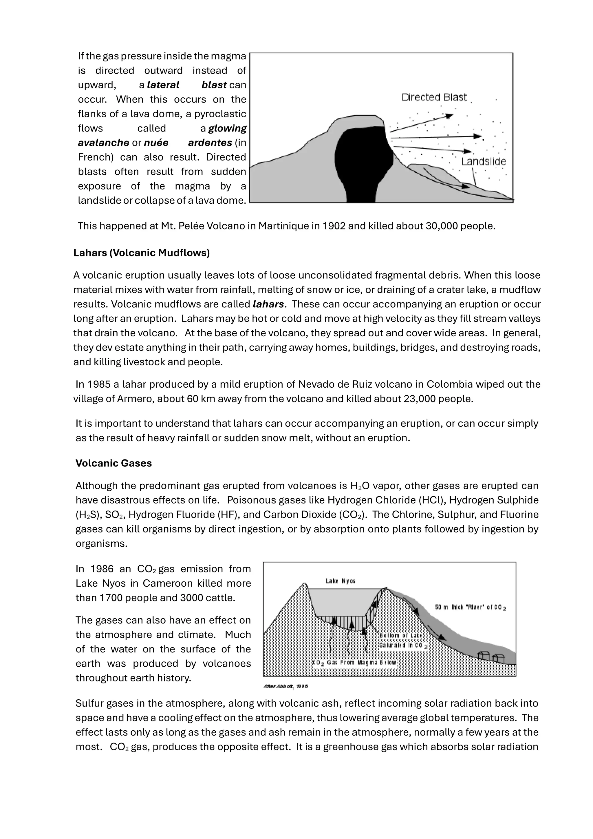
If thegaspressureinsidethemagma
is directedoutward instead of
upward, a lateral blast can
occur. When this occurs on the
flanks of a lava dome, a pyroclastic
flows called a glowing
avalanche or nuée ardentes (in
French) can also result. Directed
blasts often result from sudden
exposure of the magma by a
landslideor collapseof a lava dome.
This happened at Mt. Pelée Volcano in Martinique in 1902 and killed about 30,000 people.
Lahars (Volcanic Mudflows)
A volcanic eruption usually leaves lots of loose unconsolidated fragmental debris. When this loose
material mixes with water from rainfall, melting of snow or ice, or draining of a crater lake, a mudflow
results. Volcanic mudflows are called lahars. These can occur accompanying an eruption or occur
long after an eruption. Lahars may be hot or cold and move at high velocity as they fill stream valleys
that drain the volcano. At the base of the volcano, they spread out and cover wide areas. In general,
they dev estate anything in their path, carrying away homes, buildings, bridges, and destroying roads,
and killing livestock and people.
In 1985 a lahar produced by a mild eruption of Nevado de Ruiz volcano in Colombia wiped out the
village of Armero, about 60 km away from the volcano and killed about 23,000 people.
It is important to understand that lahars can occur accompanying an eruption, or can occur simply
as the result of heavy rainfall or sudden snow melt, without an eruption.
Volcanic Gases
Although the predominant gas erupted from volcanoes is H2O vapor, other gases are erupted can
have disastrous effects on life. Poisonous gases like Hydrogen Chloride (HCl), Hydrogen Sulphide
(H2S), SO2, Hydrogen Fluoride (HF), and Carbon Dioxide (CO2). The Chlorine, Sulphur, and Fluorine
gases can kill organisms by direct ingestion, or by absorption onto plants followed by ingestion by
organisms.
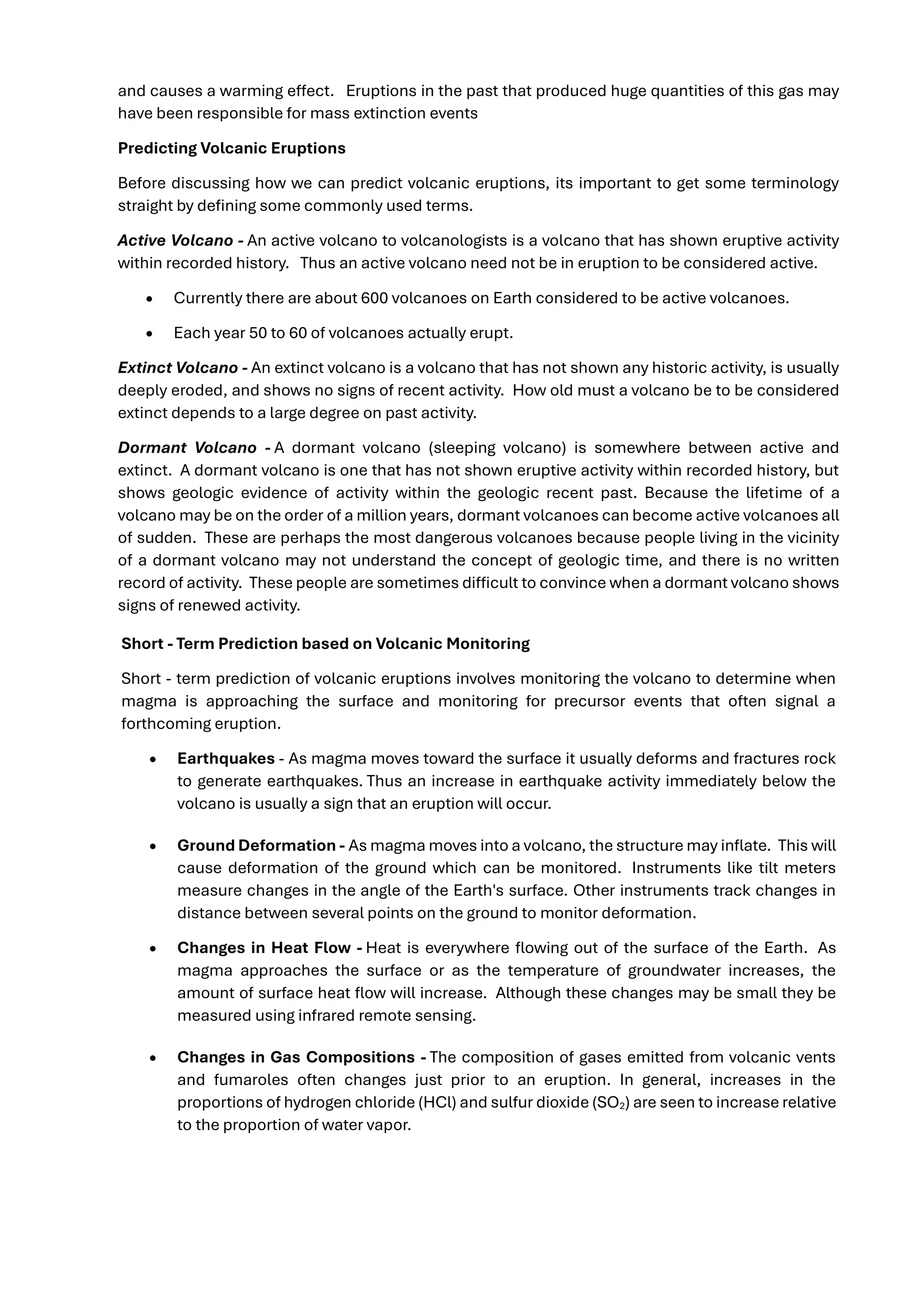
In 1986 an CO2 gas emission from
Lake Nyos in Cameroon killed more
than 1700 people and 3000 cattle.
The gases can also have an effect on
the atmosphere and climate. Much
of the water on the surface of the
earth was produced by volcanoes
throughout earth history.
Sulfur gases in the atmosphere, along with volcanic ash, reflect incoming solar radiation back into
space and have a cooling effect on the atmosphere, thus lowering average global temperatures. The
effect lasts only as long as the gases and ash remain in the atmosphere, normally a few years at the
most. CO2 gas, produces the opposite effect. It is a greenhouse gas which absorbs solar radiation
12.
and causes awarming effect. Eruptions in the past that produced huge quantities of this gas may
have been responsible for mass extinction events
Predicting Volcanic Eruptions
Before discussing how we can predict volcanic eruptions, its important to get some terminology
straight by defining some commonly used terms.
Active Volcano - An active volcano to volcanologists is a volcano that has shown eruptive activity
within recorded history. Thus an active volcano need not be in eruption to be considered active.
• Currently there are about 600 volcanoes on Earth considered to be active volcanoes.
• Each year 50 to 60 of volcanoes actually erupt.
Extinct Volcano - An extinct volcano is a volcano that has not shown any historic activity, is usually
deeply eroded, and shows no signs of recent activity. How old must a volcano be to be considered
extinct depends to a large degree on past activity.
Dormant Volcano - A dormant volcano (sleeping volcano) is somewhere between active and
extinct. A dormant volcano is one that has not shown eruptive activity within recorded history, but
shows geologic evidence of activity within the geologic recent past. Because the lifetime of a
volcano may be on the order of a million years, dormant volcanoes can become active volcanoes all
of sudden. These are perhaps the most dangerous volcanoes because people living in the vicinity
of a dormant volcano may not understand the concept of geologic time, and there is no written
record of activity. These people are sometimes difficult to convince when a dormant volcano shows
signs of renewed activity.
Short - Term Prediction based on Volcanic Monitoring
Short - term prediction of volcanic eruptions involves monitoring the volcano to determine when
magma is approaching the surface and monitoring for precursor events that often signal a
forthcoming eruption.
• Earthquakes - As magma moves toward the surface it usually deforms and fractures rock
to generate earthquakes. Thus an increase in earthquake activity immediately below the
volcano is usually a sign that an eruption will occur.
• Ground Deformation - As magma moves into a volcano, the structure may inflate. This will
cause deformation of the ground which can be monitored. Instruments like tilt meters
measure changes in the angle of the Earth's surface. Other instruments track changes in
distance between several points on the ground to monitor deformation.
• Changes in Heat Flow - Heat is everywhere flowing out of the surface of the Earth. As
magma approaches the surface or as the temperature of groundwater increases, the
amount of surface heat flow will increase. Although these changes may be small they be
measured using infrared remote sensing.
• Changes in Gas Compositions - The composition of gases emitted from volcanic vents
and fumaroles often changes just prior to an eruption. In general, increases in the
proportions of hydrogen chloride (HCl) and sulfur dioxide (SO2) are seen to increase relative
to the proportion of water vapor.
13.
In general, nosingle event can be used to predict a volcanic eruption, and thus many events are
usually monitored so that taken in total, an eruption can often be predicted. Still, each volcano
behaves somewhat differently, and until patterns are recognized for an individual volcano,
predictions vary in their reliability. Furthermore, sometimes a volcano can erupt with no precursor
events at all.
Volcanic Hazards
The main types of volcanic hazards have been discussed above, so here we only briefly discuss
them. You should make sure you understand what each of these are, and what effects each type
of hazard can have. We will not likely have time to discuss these again in detail, so the following
material is mostly for review.
Primary Effects of Volcanism
• Lava Flows - lava flows are common in Hawaiian and Strombolian type of eruptions, the
least explosive. Although they have been known to travel as fast as 64 km/hr, most are
slower and give people time to move out of the way. Thus, in general, lava flows are most
damaging to property, as they can destroy anything in their path.
• Pyroclastic Flows - Pyroclastic flows are one of the most dangerous aspects of
volcanism. They cause death by suffocation and burning. They can travel so rapidly that
few humans can escape.
• Ash falls - Although tephra falls blanket an area like snow, they are far more destructive
because tephra deposits have a density more than twice that of snow and tephra deposits
do not melt like snow an cause the collapse of roof. They and can affect areas far from the
eruption. Tephra falls destroy vegetation, including crops, and can kill livestock that eat the
ash covered vegetation. Tephra falls can cause loss of agricultural activity for years after an
eruption.
• Poisonous Gas Emissions , as discussed above.
Secondary and Tertiary Effects of Volcanism
• Mudflows (Lahars) As discussed above, mudflows can both accompany an eruption and
occur many years after an eruption. They are formed when water and loose ash deposits
come together and begin to flow. The source of water can be derived by melting of snow or
ice during the eruption, emptying of crater lakes during an eruption, or rainfall that takes
place any time with no eruption.
• Debris Avalanches, Landslides, and Debris Flows - Volcanic mountains tend to become
oversteepened as a result of the addition of new material over time as well due to inflation
of the mountain as magma intrudes. Oversteepened slopes may become unstable, leading
to a sudden slope failure that results in landslides, debris flows or debris
avalanches. Debris avalanches, landslides, and debris flows do not necessarily occur
accompanied by a volcanic eruption. There are documented cases of such occurrences
where no new magma has been erupted.
• Flooding - Drainage systems can become blocked by deposition of pyroclastic flows and
lava flows. Such blockage may create a temporary dam that could eventually fill with water
14.
and fail resultingin floods downstream from the natural dam. Volcanoes in cold climates
can melt snow and glacial ice, rapidly releasing water into the drainage system and possibly
causing floods. Jokaulhlaups occur when heating of a glacier results in rapid outburst of
water from the melting glacier.
• Tsunami - Debris avalanche events, landslides, caldera collapse events, and pyroclastic
flows entering a body of water may generate tsunami. During the 1883 eruption of Krakatau
volcano, in the straits of Sunda between Java and Sumatra, several tsunami were generated
by pyroclasticflows entering thesea and by collapseaccompanying caldera formation. The
tsunami killed about 36,400 people, some as far away from the volcano as 200 km.
• Volcanic Earthquakes - Earthquakes usually precede and accompany volcanic eruptions,
as magma intrudes and moves within the volcano. Although most volcanic earthquakes are
small, some are large enough to cause damage in the area immediately surrounding the
volcano, and some are large enough to trigger landslides and debris avalanches, such as in
the case of Mount St. Helens.
• Atmospheric Effects- Fined grained ash and sulfur gases expelled into the atmosphere
reflect solar radiations and cause cooling of the atmosphere. CO2 released by volcanoes
can cause warming of the atmosphere.