
More Related Content
Recently uploaded
Recently uploaded (18)
Featured
Featured (20)
Sincodigoica
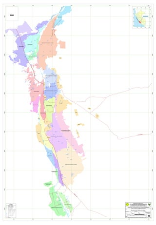
- 1. ( ! ! ! Q B ¨A ! ! A ¨A ( A ( Q ! B ! ! B A PÛA Q A Q A PÛ A A A ¨Û B ¨A B ¨Û > > ( ¨Û > > >( ¨A> > >> ! > B A B! ! Q ¨Û ¨A Q Q B ! ! ¨Û A A A B ¨Û > B A B B A A A ( A BA A ¨A A AA B Q ! ! A A A A A A A A A A ( ¨Û A ( A A A ! A A A A A B B ¨A¨A !B ¨APÛ ! ¨A > ¨Û Q Q ! !! ! A ( ¨Û B ! PÛ ¨A A ! A A A A B A A! ! ! ! A A B ( ! !(! ! ! ! ¨Û ¨Û ¨Û ( A A ( A B A ( S/C-8 S/C-6 S/C-7 CRASVI CAUCE MACACONA SETIMO SUB SECTOR DE RIEGO LA ACHIRANA PRIMER SUB SECTOR DE RIEGO LA ACHIRANA CAUCE LA MOCHICA CAUCE QUILLOAY CRASVI SEXTO SUB SECTOR DE RIEGO LA ACHIRANA CAUCE SAN AGUSTIN CAUCE YANCAY CRASVI CRASVI CAUCE LA VENTA CAUCE PARAYA LA BANDA CERRO BLANCO CAUCE TACARACA CAUCE SACTA SEGUNDO SUB SECTOR DE RIEGO LA ACHIRANA CAUCE OCUCAJE PINILLA CAUCE SAN JACINTO TERCER SUB SECTOR DE RIEGO LA ACHIRANA CRASVI CRASVI CRASVI CRASVI CRASVI CRASVI CAUCE CHANCHAMAYO LA 75 QUINTO SUB SECTOR LA ACHIRANA CUARTO SUB SECTOR DE RIEGO LA ACHIRANA CAUCE ACEQUIA NUEVA CAUCE LA MOCHICA CRASVI CAUCE PARAYA LA BANDA CERRO BLANCO CRASVI CRASVI CAUCE PARAYA LA BANDA CERRO BLANCO CRASVI S/C9 S/C-1 S/C-6 S/C-5 S/C-4 S/C-3 S/C-2 S/C-1 S/C-9 S/C-8 S/C-7 S/C-6 S/C-5 S/C-4 S/C-3 S/C-2 S/C-1 S/C10 S/C-5 S/C-4 S/C-3 S/C-2 S/C-1 S/C-2 S/C-1 S/C-9 S/C-8 S/C-7 S/C-6 S/C-5 S/C-4 S/C-3 S/C-2 S/C-1 S/C-1 S/C-9 S/C-8 S/C-7 S/C-6 S/C-5 S/C-4 S/C-2 S/C-1 S/C-9 S/C-8 S/C-7 S/C-6 S/C-5 S/C-4 S/C-3 S/C-2 S/C-1 S/C-9 S/C-8 S/C-7S/C-6 S/C-5 S/C-4 S/C-3 S/C-2 S/C-1 S/C-6 S/C-5 S/C-4 S/C-3 S/C-2 S/C-1 S/C-9 S/C-8 S/C-7 S/C-6 S/C-5 S/C-4 S/C-3 S/C-2 S/C-1 S/C-9 S/C-8 S/C-7 S/C-6 S/C-5 S/C-4 S/C-3 S/C-2 S/C-1 S/C-9 S/C-8 S/C-7 S/C-6 S/C-5 S/C-4 S/C-3 S/C-2 S/C-1 S/C-22 S/C-21 S/C-20 S/C-18 S/C-17 S/C-16 S/C-15 S/C-14 S/C-13 S/C-12 S/C-11 S/C-10 S/C-11 S/C-10 S/C-47 S/C-46 S/C-45 S/C-44 S/C-43 S/C-42 S/C-41 S/C-40 S/C-39 S/C-38 S/C-37 S/C-36 S/C-35 S/C-34 S/C-33 S/C-32 S/C-31 S/C-30 S/C-29 S/C-28 S/C-27 S/C-26 S/C-25 S/C-24 S/C-23 S/C-22 S/C-21 S/C-20 S/C-19 S/C-18 S/C-17 S/C-16 S/C-15 S/C-14 S/C-13 S/C-12 S/C-11 S/C-10 S/C-10 S/C-17 S/C-16 S/C-15 S/C-14 S/C-13 S/C-12 S/C-11 S/C-10 S/C-21 S/C-20 S/C-19 S/C-18 S/C-17 S/C-16 S/C-15 S/C-14 S/C-13 S/C-12 S/C-11 S/C-10 S/C-13 S/C-12 S/C-11S/C-10 RIOICA RIOICA YAUCA DE ROSARIO PA N AM ER IC A SUR 415000 415000 420000 420000 425000 425000 430000 430000 435000 435000 440000 440000 445000 445000 450000 450000 8410000 8410000 8415000 8415000 8420000 8420000 8425000 8425000 8430000 8430000 8435000 8435000 8440000 8440000 8445000 8445000 8450000 8450000 8455000 8455000 8460000 8460000 100000 100000 600000 600000 1100000 1100000 1600000 1600000 8000000 8000000 8500000 8500000 9000000 9000000 9500000 9500000 10000000 10000000 ZONA DE ESTUDIO OCEANO PACIFICO - TIPOS POZOS P Û MIXTO NO UTILIZABLE ¨ Û MIXTO UTILIZABLE ¨ A MIXTO UTILIZADO ! TAJO ABIERTO NO UTILIZABLE ( TAJO ABIERTO UTILIZABLE > TAJO ABIERTO UTILIZADO Q TUBULAR NO UTILIZABLE B TUBULAR UTILIZABLE A TUBULAR UTILIZADO VIAL PARCELA LEYENDA "ESTUDIO DE LA SITUACION ACTUAL DE LAS AGUAS SUBTERRANEAS EN EL VALLE DE ICA Y PAMPAS DE VILLACURI" INSTITUTO NACIONAL DE RECURSOS NATURALES INTENDENCIA DE RECURSOS HIDRICOS MINISTERIO DE AGRICULTURA ADMINISTRACION TECNICA DEL DISTRITO DE RIEGO ICA FUENTE: BASE CARTOGRAFICA DEL PROYECTO ESPECIAL DE TITULACION DE TIERRAS - PETT 2004. ENERO 2008 UBICACION DE POZOS SIN CODIGO ESCALA: 02 PLANO N°: RESPONSABLE: APROBADO: Ing. Christian Payano Ing. Jorge Arestegui Navarro DEPARTAMENTO: ICA PROVINCIA: ICA DISTRITO: ICA, SUBTANJALLA, SANTIAGO, OCUCAJE, PARCONA, ETC 1:45,000 0 610 1,220 1,830 2,440305 Meters SIG: Bach. Ing. M.D.F PLANO: