Report
Share

Recommended
Impacts of the Traveston Crossing Dam on Estuarine Water Quality
The document contains 22 figures related to environmental flows and impacts in a river catchment area. The figures show assessments of water demand, key issues from public submissions, perceived cumulative impacts of reduced environmental flows, maps of the catchment area and wetlands, conceptual models of influences on wildlife, nutrient cycling diagrams, hydrological modeling results, historical flood plume data, and preliminary optimized flow duration curves.
Introduction and Background of "The River, the Bay and the Strait" public forum
The document discusses a public forum on whether South East Queensland needs a new dam. It provides background on the decision making process for the proposed dam and reasons why a dam is not needed and there are better alternatives. These alternatives include reducing water usage, capturing stormwater, dry cooling for power stations, and desalination. The document also summarizes presentations that were given at the forum about the ecology of estuaries and how river flows play an important role in maintaining a complex and balanced ecosystem.
Performance Review - 2010-11
The document appears to contain the name "AbhishekS" repeated many times over multiple lines without any other text. It does not provide any clear information that can be summarized in 3 sentences or less.
Rainfall, evaporation & river runoff impacts on Hervey Bay salinity
Presentation by Assoc. Prof. Joachim Ribbe from University of Southern Queensland regarding the role of rainfall runoff and river flow in controlling salinity profiles in Hervey Bay.
TREES OF KNOWLEDGE The remarkable trees in this collection are a record of ec...
Music: Lindsay Mottershead; Photos: A. Mackay and L. Titmarsh.
Recently threatened by a dam proposed by the Queensland government. Most of the ancient fig species were in the proposed dam’s “footprint” and yet they were omitted from state government survey maps accompanying the dam report which has been sent to the Federal government for approval. Many creatures living in the mangroves of the Mary River estuaries rely on fresh water flows, yet they were ignored in the proposed dam’s environmental impact statement. With science like this, it is bizarre that Queenslanders are expected to trust their leaders in habitat protection for endangered species.
Kernenergie en de toekomst
Presentatie tot blok 1, onderzoek & analyse imago kernenergie in Nederland
Traveston Dam: The Ramsar Ramifications
The document discusses several key points regarding intergenerational equity and Ramsar wetlands:
1) Ramsar assessments of impacts on wetlands should consider both the local ecosystem scale and broader scales like the entire river basin or migratory range of affected species.
2) Environmental impact assessments must be fully incorporated into existing legal planning processes rather than seen as separate add-ons.
3) Assessments should use the ecosystem approach and consider proper temporal and spatial scales, biodiversity values, and stakeholder participation.
4) The EIS fails to adequately address policies in various plans regarding protection of wetlands, water resources, biodiversity, and coastal environments.
2012 landcare conference
The 2012 National Landcare Conference brought together over 900 people involved in the Landcare movement across Australia and internationally. Keynote speakers including David Suzuki and Tim Flannery gave inspiring talks on environmental issues. Many presentations focused on using social media to promote Landcare's message and the successes of the Victorian Landcare program. Conference attendees found the farmer-led research presentations and displays on controlling weeds and soil health most memorable. The gala dinner celebrated the National Landcare Award winners and was attended by notable Australians like Bob Hawke and Jack Thompson.
Berry Climate Change Projections And Implication
1) The document discusses climate change projections from various global circulation models and emission scenarios and their implications for areas like the Mary River region.
2) The projections show increases in average maximum temperatures, decreases in annual precipitation, and more frequent extreme heat days in the future for the region.
3) However, differing climate models and scenarios can provide different projections, so future research is needed to increase the accuracy of rainfall projections to local areas.
A better alternative than Traveston Crossing dam
Presentation regarding options to reduce water consumption in South East Queensland. Presented at the AWA Qld Regional Conference in Nov 2007.
Phosphorus in the Mary and vulnerability of storages to
The document discusses phosphorus levels in sediments in the Mary River and how it relates to algal blooms. It aims to 1) identify variations of phosphorus in river sediments, 2) use background ratios as a guide for target setting to reduce phosphorus, and 3) suggest using geochemical ratios to monitor phosphorus exports from farms. Phosphorus can enter sediments in insoluble, organic, and mineral forms by binding to iron oxides, being assimilated by organisms, or included with soil minerals. Wetlands can help reduce soil loss and retain phosphorus and sediments.
Why the Mary is at risk from low flows
The document discusses the risks that proposed infrastructure plans pose to the Mary River's low flows. It argues that removing water from the river and constructing dams will likely exacerbate existing problems during dry seasons, as the river already experiences major issues with low flows. To protect the low-flow regime and mitigate these impacts, significant environmental flow releases would be needed from any new dams, but this would reduce the economic viability of the proposed infrastructure projects. There may be better options for urban water supply than these plans.
A visual summary of the Greater Mary Association Inc Activities
The Greater Mary Association Inc is an award winning community group based in the Maryborough Hervey Bay area that was formed to protect the Mary River and Great Sandy Strait from the proposed Traveston Crossing Dam. This slideshow offers a brief visual summary of the history of the group since it began in November 2007.
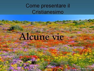
Il Credo apostolico
Come riassunto del programma di Seconda, cosa c'è di meglio del Credo apostolico?
More Related Content
Viewers also liked
Traveston Dam: The Ramsar Ramifications
The document discusses several key points regarding intergenerational equity and Ramsar wetlands:
1) Ramsar assessments of impacts on wetlands should consider both the local ecosystem scale and broader scales like the entire river basin or migratory range of affected species.
2) Environmental impact assessments must be fully incorporated into existing legal planning processes rather than seen as separate add-ons.
3) Assessments should use the ecosystem approach and consider proper temporal and spatial scales, biodiversity values, and stakeholder participation.
4) The EIS fails to adequately address policies in various plans regarding protection of wetlands, water resources, biodiversity, and coastal environments.
2012 landcare conference
The 2012 National Landcare Conference brought together over 900 people involved in the Landcare movement across Australia and internationally. Keynote speakers including David Suzuki and Tim Flannery gave inspiring talks on environmental issues. Many presentations focused on using social media to promote Landcare's message and the successes of the Victorian Landcare program. Conference attendees found the farmer-led research presentations and displays on controlling weeds and soil health most memorable. The gala dinner celebrated the National Landcare Award winners and was attended by notable Australians like Bob Hawke and Jack Thompson.
Berry Climate Change Projections And Implication
1) The document discusses climate change projections from various global circulation models and emission scenarios and their implications for areas like the Mary River region.
2) The projections show increases in average maximum temperatures, decreases in annual precipitation, and more frequent extreme heat days in the future for the region.
3) However, differing climate models and scenarios can provide different projections, so future research is needed to increase the accuracy of rainfall projections to local areas.
A better alternative than Traveston Crossing dam
Presentation regarding options to reduce water consumption in South East Queensland. Presented at the AWA Qld Regional Conference in Nov 2007.
Phosphorus in the Mary and vulnerability of storages to
The document discusses phosphorus levels in sediments in the Mary River and how it relates to algal blooms. It aims to 1) identify variations of phosphorus in river sediments, 2) use background ratios as a guide for target setting to reduce phosphorus, and 3) suggest using geochemical ratios to monitor phosphorus exports from farms. Phosphorus can enter sediments in insoluble, organic, and mineral forms by binding to iron oxides, being assimilated by organisms, or included with soil minerals. Wetlands can help reduce soil loss and retain phosphorus and sediments.
Why the Mary is at risk from low flows
The document discusses the risks that proposed infrastructure plans pose to the Mary River's low flows. It argues that removing water from the river and constructing dams will likely exacerbate existing problems during dry seasons, as the river already experiences major issues with low flows. To protect the low-flow regime and mitigate these impacts, significant environmental flow releases would be needed from any new dams, but this would reduce the economic viability of the proposed infrastructure projects. There may be better options for urban water supply than these plans.
A visual summary of the Greater Mary Association Inc Activities
The Greater Mary Association Inc is an award winning community group based in the Maryborough Hervey Bay area that was formed to protect the Mary River and Great Sandy Strait from the proposed Traveston Crossing Dam. This slideshow offers a brief visual summary of the history of the group since it began in November 2007.
Il Credo apostolico
Come riassunto del programma di Seconda, cosa c'è di meglio del Credo apostolico?
Viewers also liked (10)
Phosphorus in the Mary and vulnerability of storages to
Phosphorus in the Mary and vulnerability of storages to
A visual summary of the Greater Mary Association Inc Activities
A visual summary of the Greater Mary Association Inc Activities