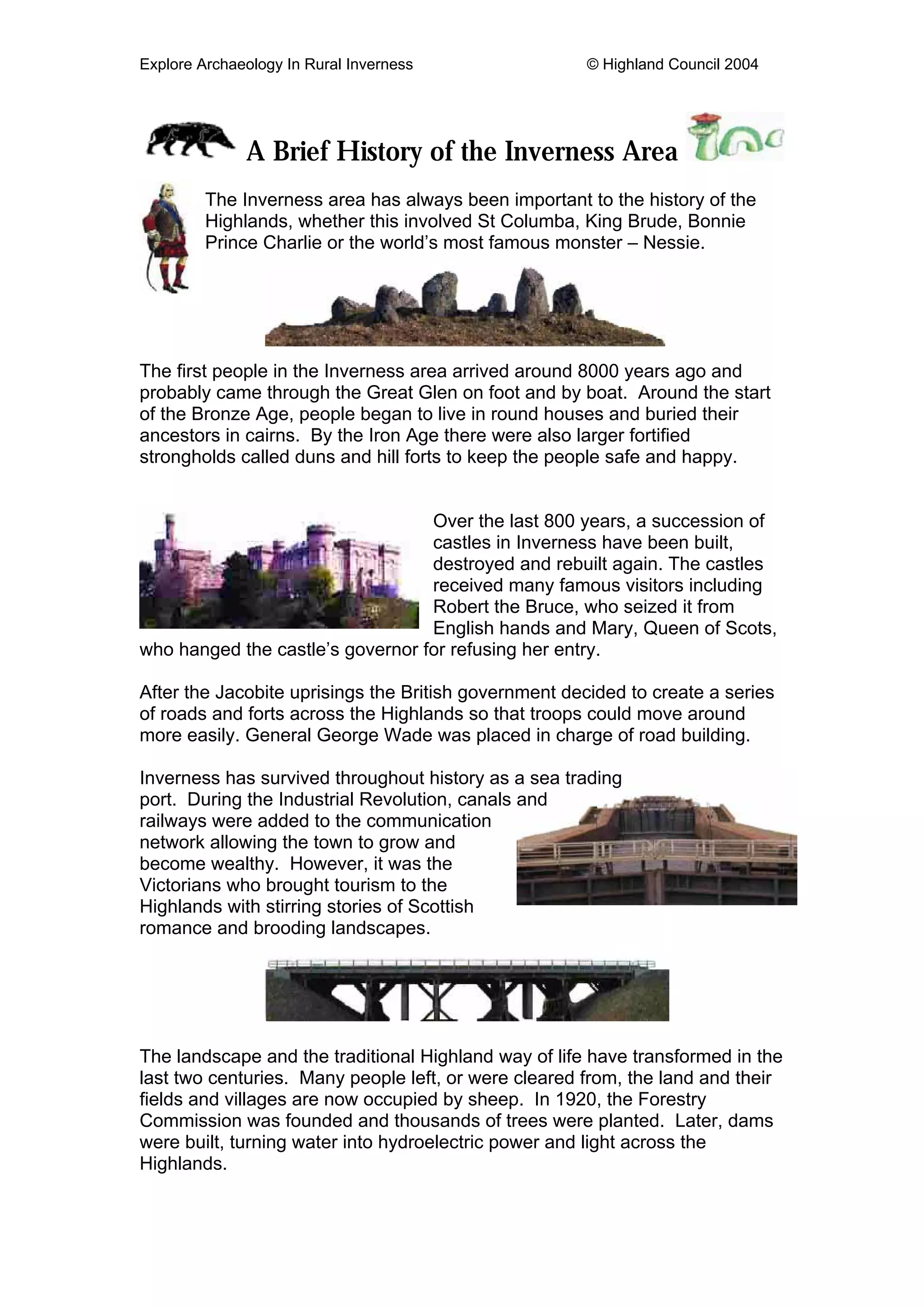
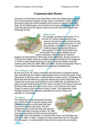
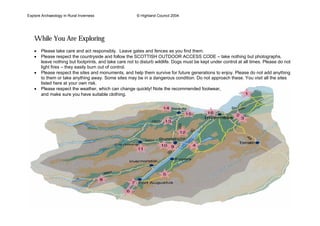
Explore Archaeology In Rural Inverness © Highland Council 2004
A Brief History of the Inverness Area
The Inverness area has always been important to the history of the
Highlands, whether this involved St Columba, King Brude, Bonnie
Prince Charlie or the world’s most famous monster – Nessie.
The first people in the Inverness area arrived around 8000 years ago and
probably came through the Great Glen on foot and by boat. Around the start
of the Bronze Age, people began to live in round houses and buried their
ancestors in cairns. By the Iron Age there were also larger fortified
strongholds called duns and hill forts to keep the people safe and happy.
Over the last 800 years, a succession of
castles in Inverness have been built,
destroyed and rebuilt again. The castles
received many famous visitors including
Robert the Bruce, who seized it from
English hands and Mary, Queen of Scots,
who hanged the castle’s governor for refusing her entry.
After the Jacobite uprisings the British government decided to create a series
of roads and forts across the Highlands so that troops could move around
more easily. General George Wade was placed in charge of road building.
Inverness has survived throughout history as a sea trading
port. During the Industrial Revolution, canals and
railways were added to the communication
network allowing the town to grow and
become wealthy. However, it was the
Victorians who brought tourism to the
Highlands with stirring stories of Scottish
romance and brooding landscapes.
The landscape and the traditional Highland way of life have transformed in the
last two centuries. Many people left, or were cleared from, the land and their
fields and villages are now occupied by sheep. In 1920, the Forestry
Commission was founded and thousands of trees were planted. Later, dams
were built, turning water into hydroelectric power and light across the
Highlands.
Explore Archaeology In Rural Inverness © Highland Council 2004
Communication Routes
Inverness is at the head of the Great Glen, which has always been a natural
line of communication whether by foot, water or horseback. Today some of
the ancient paths can still be travelled (one of which is now the Great Glen
Way). By the Middle Ages, sea travel from Inverness was frequent. In 1708
Inverness gained its first regular postal service with deliveries weekly from
Edinburgh by foot.
Military Roads
The Jacobite uprisings from the late 17th
to
the mid 18th
century meant that the area
around Inverness became a focal point for
both Government and rebel forces. In 1724
King George I responded to the Jacobite
threat by appointing General Wade as
Commander in Chief of North Britain and
commanded him to quash rebellion by any
means necessary. Wade started an intensive
program of road building to allow easy troop mobilization. By the summer of
1725 the first military road was complete and before Wade left the Highlands
in 1740 his roads stretched across the area. Today the military roads still
underlie parts of the A9, A887, B861 and B862, and the Corrieyairack Pass is
a popular route for hikers between Fort Augustus and Dalwhinnie.
The Caledonian Canal
By the end of the 18th
century Inverness had returned to a peaceful trading
town and although the military roads enabled carts to travel with goods, it was
still quicker to travel by water. It was decided to create a short cut between the
North Sea and the Atlantic by using the natural route of the Great Glen. The
Caledonian Canal was constructed at a cost of £840,000. Its building took 17
years and was finally finished in 1822. Now it consists of 22 miles of canal and
29 locks whilst using 38 miles of Loch Lochy, Loch Oich and Loch Ness.
Today it is easy to visit the canal or take a cruise. The Caledonian Canal
Heritage Centre at Fort Augustus describes the canal’s history and
operation in more detail.
The Railway
The Caledonian Canal enhanced Inverness
as a trading hub but it was the railway which
helped to create the tourist trade that fuels
the economy of the area today. The first
railway line in the Inverness area was opened
in 1855 and linked Inverness to Nairn. By 1865
Inverness was linked to Perth and thus joining the
Highlands to the rest of Britain. A shortened line south via Carrbridge was
opened in 1898. In 1903, a railway line was constructed into Fort Augustus
from Invergarry. It is still possible to trace this line across the countryside.
Explore Archaeology In Rural Inverness © Highland Council 2004
While You Are Exploring
• Please take care and act responsibly. Leave gates and fences as you find them.
• Please respect the countryside and follow the SCOTTISH OUTDOOR ACCESS CODE – take nothing but photographs,
leave nothing but footprints, and take care not to disturb wildlife. Dogs must be kept under control at all times. Please do not
light fires – they easily burn out of control.
• Please respect the sites and monuments, and help them survive for future generations to enjoy. Please do not add anything
to them or take anything away. Some sites may be in a dangerous condition. Do not approach these. You visit all the sites
listed here at your own risk.
• Please respect the weather, which can change quickly! Note the recommended footwear,
and make sure you have suitable clothing.
Explore Archaeology In Rural Inverness © Highland Council 2004
Fort George
Fort George was completed in
1769 and had been designed to
defend against the prospect of
another Jacobite uprising. Today
the fort daingnreach buildings are
shared by the army and Historic
Scotland, they show a fascinating
insight into both 18th
Century and
modern army barracks.
Fort George is located 6 miles from Nairn
and 11 miles from Inverness. It is
signposted from the A96 and the A9.
Culloden
Battlefield
By 1746 the Jacobite uprising and
support for Bonnie Prince Charlie
was a significant threat to the
government. On 16th
April 1746, the
Jacobite army were out numbered
and defeated by government troops
on Culloden Moor. The National
Trust for Scotland has
now reconstructed
what some of the
battlefield blàr will
have looked like on
that day. The site
also includes a
visitor centre that explains the
history of the Jacobite cause.
Culloden is situated off the B9006 and is
signposted from the A9 just outside
Inverness.
Balnuaran of
Clava
Three prehistoric
cairns at
Balnuaran of
Clava were
excavated in the 19th
Century. The
thirty similar known cairns càrn in
Scotland have been named after
them – as ‘Clava-type’ cairns. The
site is now under the care of
Historic Scotland and survives as a
spectacular testament to early
prehistoric burial practice.
This site is situated just over a mile from
Culloden Battlefield. Travel from Inverness
east along the B9006, continue past the
battlefield and take the next turn right
(signposted to Clava Cairns). Go straight
across at the junction, over the river and
turn right. A car park lies on the right hand
side.
General Wades
Change House
The remains of the Change House
now survive only as a ruinous
rectangle of stone walls. This was
once an inn where people travelling
along the military road from
Inverness to Fort Augustus could
find shelter and food, and could
‘change’ horses or carters.
There is car-parking at the first picnic area
north of Inverfarigaig on the B852 and the
change house lies a short walk along the
wooded loch shore. The Forestry
Commission has also included the site in a
way-marked walk of about two miles.
= Parking Available = Easy: Sensible Footwear
= Wheelchair Access = Moderate: Waterproof Footwear
= Admission Charge = Strenuous: Hillwalking Boots
English = Gaelic
Explore Archaeology In Rural Inverness © Highland Council 2004
Whitebridge
Whitebridge has one of the finest
surviving examples of a single
span, hump-backed bridge, built by
General Wade’s troops as they
created a road link between
Inverness and Fort Augustus.
Today the modern road bypasses
the old bridge drochaid and it now
stands as a monument to General
Wade’s extensive and successful
road network.
The bridge lies in the village of
Whitebridge, reached along the B862 from
Inverness.
Bridge of Oich
In 1849 floods swept through the
Great Glen, breaching the
Caledonian Canal and destroying
the stone bridge over the river
Oich. Its replacement is a fine
example of an industrial double
cantilever bridge. Now in the care
of Historic Scotland, this site gives
an insight into Scotland’s industrial
heritage.
The Bridge of Oich is signposted from the
A82 south from Fort Augustus.
Torr Dhuin
The fortified dun known as Torr
Dhuin lies on the high ground
overlooking the River Oich and the
Great Glen. This later prehistoric
fort will have been seen as a
symbol of power by the people who
lived in the valley gleann below.
Today the Forestry Commission
has created a path network to
reach this site and experience the
breath-taking views.
Travel north from Fort Augustus on the
A82 and follow signs to Auchterawe.
Continue past the Forestry Commission
offices for the Torr Dhuin car park.
Mackenzies Cairn
and Grave
Roderick Mackenzie (famed as a
look-a-like of Bonnie Prince
Charlie) died at the hands of
Cumberland’s government forces in
July 1746, three months after
Culloden. Roderick was beheaded
and his head ceann was taken to
Fort Augustus for formal
identification which allowed Prince
Charlie the precious time he
needed to escape. This cairn
marks where Roderick is said to
have been slain; and the grave
holds his body - minus its head.
The cairn is visible from the A887 roadside
approximately 14 miles west of
Invermoriston. The grave can be found by
following the path down towards the river.
= Parking Available = Easy: Sensible Footwear
= Wheelchair Access = Moderate: Waterproof Footwear
= Admission Charge = Strenuous: Hillwalking Boots
English = Gaelic
Explore Archaeology In Rural Inverness © Highland Council 2004
Urquhart
Castle
Urquhart Castle was once one of
Scotland’s great castles and still
dominates the banks of Loch Ness.
It has been lying in ruins since
1691, when government forces
destroyed it to prevent the castle
caisteal falling into enemy hands.
Historic Scotland now cares for this
site and provides a visitor centre
that explains the castle’s history.
Urquhart Castle is situated just south of
Drumnadrochit on the A82.
Craig Mony
Craig Mony lies on the end of a
high ridge between Glen Urquhart
and Glen Coilltie, overlooking Loch
Ness. Legend has it that the Norse
king, Monie was besieged at this
fortification and killed on the plains
below whilst trying to escape.
Today the site is looked after by the
Forestry Commission and provides
a fantastic outlook across Loch
Ness.
Park in the main Drumnadrochit car park
and follow the Craigmonie and Balmacaan
woodland walks (signposted in the car
park).
Corrimony Cairn
Corrimony Cairn is a Clava-type
cairn and was excavated in 1952.
Today the site is maintained by The
National Trust for Scotland and it is
possible to enter the cairn chamber
rùm and to see the curious stone
cup-markings.
Signposted from the A831, it lies on the
main road to Corrimony, with parking on
the left before the site. This site lies next to
a bird reserve.
Abriachan Hut
Reconstruction
A well maintained reconstruction of
a Bronze Age house lies in
woodland near Abriachan (such
sites are often described as Hut
Circles). The reconstruction forms
part of a woodland coille
interpretation project which
includes numerous other activities
to keep you amused.
Travel down the A82 from Inverness and
turn west towards Abriachan (on road
signposted ‘Abriachan 1½’). The
Abriachan Forest Trust
car park lies
approximately 2 miles
from the village and
is signposted on
the Foxhole road.
= Parking Available = Easy: Sensible Footwear
= Wheelchair Access = Moderate: Waterproof Footwear
= Admission Charge = Strenuous: Hillwalking Boots
English = Gaelic
Explore Archaeology In Rural Inverness © Highland Council 2004
Kiltarlity Old
Parish Church
There are references to a church
eaglais on this site dating back to
1227, but the ruins visible today are
relatively new,
dating only to the
16th
Century.
The site lies
within a
beautiful setting
with wonderful
riverside views
and the Kilmorack hydro power
station lies just up river. The
graveyard cladh is still in use today.
Kiltarlity Old Parish Church can be found
from the A831 by turning east along the
road signposted ‘Kiltarlity 2½ Eskadale
4¾’ and then turning left into the car park
immediately after the bridge.
Beauly Priory
and Mercat Cross
Beauly Priory was founded in 1230
as one of only three Valliscaulian
abbeys in Scotland. However, by
the end of the Middle Ages its
allegiances changed and it became
a Cistercian abbey abaid. Beauly
Mercat Cross lies close
to the priory and was
erected in 1430
when Beauly
acquired the
right to hold its
own markets.
Beauly Priory and
Mercat Cross are
both located at the northern end of Beauly
High Street.
Wardlaw
Mausoleum
Wardlaw Mausoleum dates back to
1722 and has a rich history with
references to an earlier church on
this site from the early 17th
century.
This site is a superb example of
Highland burial tradition, displaying
many extremely ornate
gravestones clach uaghach.
Wardlaw lies in Kirkhill and is signposted
from the A862 when traveling
from Inverness. The site lies
half a mile down Wardlaw
Road from the centre of the
village.
Craig Phadrig
The striking landmark of Craig
Phadrig hill fort is believed to
have once been the stronghold
dún of the Pictish King,Brude.
Tradition holds that Craig
Phadrig is where St Columba met
King Brude to bring Christianity to
this area.
Craig Phadrig can be reached by traveling
south on the A82 out of Inverness, turning
right past the canal bridge towards
Kinmylies. Along this road, take a left at the
lights and travel up the hill, go straight
across the roundabout and follow signs for
Craig Phadrig forest.
= Parking Available = Easy: Sensible Footwear
= Wheelchair Access = Moderate: Waterproof Footwear
= Admission Charge = Strenuous: Hillwalking Boots
English = Gaelic
Explore Archaeology In Rural Inverness © Highland Council 2004
For Further Information
Caledonian Canal Centre:
01320 366 493,
www.scottishcanals.co.uk
Inverness Museum & Art Gallery:
01463 237114,
www.invernessmuseum.com.
Highland Council Countryside Rangers:
01463 724312
Historic Scotland:
0131 668 8600,
www.historic-scotland.gov.uk
National Trust for Scotland:
0131 243 9300,
www.nts.org.uk
Visit Scotland:
www.visitscotland.com
Archaeological sites are all around the Highlands and if you discover anything
please send details to:
Archaeology Unit
Planning and Development Service
Highland Council, Glenurquhart Road
Inverness IV3 5NX.
Tel: 01463 702250
email: archaeology@highland.gov.uk
The Front Cover Image is of Urquhart Castle. This leaflet was produced by the Inverness Access to Archaeology Project, Funded by the Highland Council,
Historic Scotland and Inverness and Nairn Enterprise.
Project officer and Leaflet Designer: David Lock © Highland Council 2004

Rural

  • 1.
    Explore Archaeology InRural Inverness © Highland Council 2004 A Brief History of the Inverness Area The Inverness area has always been important to the history of the Highlands, whether this involved St Columba, King Brude, Bonnie Prince Charlie or the world’s most famous monster – Nessie. The first people in the Inverness area arrived around 8000 years ago and probably came through the Great Glen on foot and by boat. Around the start of the Bronze Age, people began to live in round houses and buried their ancestors in cairns. By the Iron Age there were also larger fortified strongholds called duns and hill forts to keep the people safe and happy. Over the last 800 years, a succession of castles in Inverness have been built, destroyed and rebuilt again. The castles received many famous visitors including Robert the Bruce, who seized it from English hands and Mary, Queen of Scots, who hanged the castle’s governor for refusing her entry. After the Jacobite uprisings the British government decided to create a series of roads and forts across the Highlands so that troops could move around more easily. General George Wade was placed in charge of road building. Inverness has survived throughout history as a sea trading port. During the Industrial Revolution, canals and railways were added to the communication network allowing the town to grow and become wealthy. However, it was the Victorians who brought tourism to the Highlands with stirring stories of Scottish romance and brooding landscapes. The landscape and the traditional Highland way of life have transformed in the last two centuries. Many people left, or were cleared from, the land and their fields and villages are now occupied by sheep. In 1920, the Forestry Commission was founded and thousands of trees were planted. Later, dams were built, turning water into hydroelectric power and light across the Highlands.
  • 2.
    Explore Archaeology InRural Inverness © Highland Council 2004 Communication Routes Inverness is at the head of the Great Glen, which has always been a natural line of communication whether by foot, water or horseback. Today some of the ancient paths can still be travelled (one of which is now the Great Glen Way). By the Middle Ages, sea travel from Inverness was frequent. In 1708 Inverness gained its first regular postal service with deliveries weekly from Edinburgh by foot. Military Roads The Jacobite uprisings from the late 17th to the mid 18th century meant that the area around Inverness became a focal point for both Government and rebel forces. In 1724 King George I responded to the Jacobite threat by appointing General Wade as Commander in Chief of North Britain and commanded him to quash rebellion by any means necessary. Wade started an intensive program of road building to allow easy troop mobilization. By the summer of 1725 the first military road was complete and before Wade left the Highlands in 1740 his roads stretched across the area. Today the military roads still underlie parts of the A9, A887, B861 and B862, and the Corrieyairack Pass is a popular route for hikers between Fort Augustus and Dalwhinnie. The Caledonian Canal By the end of the 18th century Inverness had returned to a peaceful trading town and although the military roads enabled carts to travel with goods, it was still quicker to travel by water. It was decided to create a short cut between the North Sea and the Atlantic by using the natural route of the Great Glen. The Caledonian Canal was constructed at a cost of £840,000. Its building took 17 years and was finally finished in 1822. Now it consists of 22 miles of canal and 29 locks whilst using 38 miles of Loch Lochy, Loch Oich and Loch Ness. Today it is easy to visit the canal or take a cruise. The Caledonian Canal Heritage Centre at Fort Augustus describes the canal’s history and operation in more detail. The Railway The Caledonian Canal enhanced Inverness as a trading hub but it was the railway which helped to create the tourist trade that fuels the economy of the area today. The first railway line in the Inverness area was opened in 1855 and linked Inverness to Nairn. By 1865 Inverness was linked to Perth and thus joining the Highlands to the rest of Britain. A shortened line south via Carrbridge was opened in 1898. In 1903, a railway line was constructed into Fort Augustus from Invergarry. It is still possible to trace this line across the countryside.
  • 3.
    Explore Archaeology InRural Inverness © Highland Council 2004 While You Are Exploring • Please take care and act responsibly. Leave gates and fences as you find them. • Please respect the countryside and follow the SCOTTISH OUTDOOR ACCESS CODE – take nothing but photographs, leave nothing but footprints, and take care not to disturb wildlife. Dogs must be kept under control at all times. Please do not light fires – they easily burn out of control. • Please respect the sites and monuments, and help them survive for future generations to enjoy. Please do not add anything to them or take anything away. Some sites may be in a dangerous condition. Do not approach these. You visit all the sites listed here at your own risk. • Please respect the weather, which can change quickly! Note the recommended footwear, and make sure you have suitable clothing.
  • 4.
    Explore Archaeology InRural Inverness © Highland Council 2004 Fort George Fort George was completed in 1769 and had been designed to defend against the prospect of another Jacobite uprising. Today the fort daingnreach buildings are shared by the army and Historic Scotland, they show a fascinating insight into both 18th Century and modern army barracks. Fort George is located 6 miles from Nairn and 11 miles from Inverness. It is signposted from the A96 and the A9. Culloden Battlefield By 1746 the Jacobite uprising and support for Bonnie Prince Charlie was a significant threat to the government. On 16th April 1746, the Jacobite army were out numbered and defeated by government troops on Culloden Moor. The National Trust for Scotland has now reconstructed what some of the battlefield blàr will have looked like on that day. The site also includes a visitor centre that explains the history of the Jacobite cause. Culloden is situated off the B9006 and is signposted from the A9 just outside Inverness. Balnuaran of Clava Three prehistoric cairns at Balnuaran of Clava were excavated in the 19th Century. The thirty similar known cairns càrn in Scotland have been named after them – as ‘Clava-type’ cairns. The site is now under the care of Historic Scotland and survives as a spectacular testament to early prehistoric burial practice. This site is situated just over a mile from Culloden Battlefield. Travel from Inverness east along the B9006, continue past the battlefield and take the next turn right (signposted to Clava Cairns). Go straight across at the junction, over the river and turn right. A car park lies on the right hand side. General Wades Change House The remains of the Change House now survive only as a ruinous rectangle of stone walls. This was once an inn where people travelling along the military road from Inverness to Fort Augustus could find shelter and food, and could ‘change’ horses or carters. There is car-parking at the first picnic area north of Inverfarigaig on the B852 and the change house lies a short walk along the wooded loch shore. The Forestry Commission has also included the site in a way-marked walk of about two miles. = Parking Available = Easy: Sensible Footwear = Wheelchair Access = Moderate: Waterproof Footwear = Admission Charge = Strenuous: Hillwalking Boots English = Gaelic
  • 5.
    Explore Archaeology InRural Inverness © Highland Council 2004 Whitebridge Whitebridge has one of the finest surviving examples of a single span, hump-backed bridge, built by General Wade’s troops as they created a road link between Inverness and Fort Augustus. Today the modern road bypasses the old bridge drochaid and it now stands as a monument to General Wade’s extensive and successful road network. The bridge lies in the village of Whitebridge, reached along the B862 from Inverness. Bridge of Oich In 1849 floods swept through the Great Glen, breaching the Caledonian Canal and destroying the stone bridge over the river Oich. Its replacement is a fine example of an industrial double cantilever bridge. Now in the care of Historic Scotland, this site gives an insight into Scotland’s industrial heritage. The Bridge of Oich is signposted from the A82 south from Fort Augustus. Torr Dhuin The fortified dun known as Torr Dhuin lies on the high ground overlooking the River Oich and the Great Glen. This later prehistoric fort will have been seen as a symbol of power by the people who lived in the valley gleann below. Today the Forestry Commission has created a path network to reach this site and experience the breath-taking views. Travel north from Fort Augustus on the A82 and follow signs to Auchterawe. Continue past the Forestry Commission offices for the Torr Dhuin car park. Mackenzies Cairn and Grave Roderick Mackenzie (famed as a look-a-like of Bonnie Prince Charlie) died at the hands of Cumberland’s government forces in July 1746, three months after Culloden. Roderick was beheaded and his head ceann was taken to Fort Augustus for formal identification which allowed Prince Charlie the precious time he needed to escape. This cairn marks where Roderick is said to have been slain; and the grave holds his body - minus its head. The cairn is visible from the A887 roadside approximately 14 miles west of Invermoriston. The grave can be found by following the path down towards the river. = Parking Available = Easy: Sensible Footwear = Wheelchair Access = Moderate: Waterproof Footwear = Admission Charge = Strenuous: Hillwalking Boots English = Gaelic
  • 6.
    Explore Archaeology InRural Inverness © Highland Council 2004 Urquhart Castle Urquhart Castle was once one of Scotland’s great castles and still dominates the banks of Loch Ness. It has been lying in ruins since 1691, when government forces destroyed it to prevent the castle caisteal falling into enemy hands. Historic Scotland now cares for this site and provides a visitor centre that explains the castle’s history. Urquhart Castle is situated just south of Drumnadrochit on the A82. Craig Mony Craig Mony lies on the end of a high ridge between Glen Urquhart and Glen Coilltie, overlooking Loch Ness. Legend has it that the Norse king, Monie was besieged at this fortification and killed on the plains below whilst trying to escape. Today the site is looked after by the Forestry Commission and provides a fantastic outlook across Loch Ness. Park in the main Drumnadrochit car park and follow the Craigmonie and Balmacaan woodland walks (signposted in the car park). Corrimony Cairn Corrimony Cairn is a Clava-type cairn and was excavated in 1952. Today the site is maintained by The National Trust for Scotland and it is possible to enter the cairn chamber rùm and to see the curious stone cup-markings. Signposted from the A831, it lies on the main road to Corrimony, with parking on the left before the site. This site lies next to a bird reserve. Abriachan Hut Reconstruction A well maintained reconstruction of a Bronze Age house lies in woodland near Abriachan (such sites are often described as Hut Circles). The reconstruction forms part of a woodland coille interpretation project which includes numerous other activities to keep you amused. Travel down the A82 from Inverness and turn west towards Abriachan (on road signposted ‘Abriachan 1½’). The Abriachan Forest Trust car park lies approximately 2 miles from the village and is signposted on the Foxhole road. = Parking Available = Easy: Sensible Footwear = Wheelchair Access = Moderate: Waterproof Footwear = Admission Charge = Strenuous: Hillwalking Boots English = Gaelic
  • 7.
    Explore Archaeology InRural Inverness © Highland Council 2004 Kiltarlity Old Parish Church There are references to a church eaglais on this site dating back to 1227, but the ruins visible today are relatively new, dating only to the 16th Century. The site lies within a beautiful setting with wonderful riverside views and the Kilmorack hydro power station lies just up river. The graveyard cladh is still in use today. Kiltarlity Old Parish Church can be found from the A831 by turning east along the road signposted ‘Kiltarlity 2½ Eskadale 4¾’ and then turning left into the car park immediately after the bridge. Beauly Priory and Mercat Cross Beauly Priory was founded in 1230 as one of only three Valliscaulian abbeys in Scotland. However, by the end of the Middle Ages its allegiances changed and it became a Cistercian abbey abaid. Beauly Mercat Cross lies close to the priory and was erected in 1430 when Beauly acquired the right to hold its own markets. Beauly Priory and Mercat Cross are both located at the northern end of Beauly High Street. Wardlaw Mausoleum Wardlaw Mausoleum dates back to 1722 and has a rich history with references to an earlier church on this site from the early 17th century. This site is a superb example of Highland burial tradition, displaying many extremely ornate gravestones clach uaghach. Wardlaw lies in Kirkhill and is signposted from the A862 when traveling from Inverness. The site lies half a mile down Wardlaw Road from the centre of the village. Craig Phadrig The striking landmark of Craig Phadrig hill fort is believed to have once been the stronghold dún of the Pictish King,Brude. Tradition holds that Craig Phadrig is where St Columba met King Brude to bring Christianity to this area. Craig Phadrig can be reached by traveling south on the A82 out of Inverness, turning right past the canal bridge towards Kinmylies. Along this road, take a left at the lights and travel up the hill, go straight across the roundabout and follow signs for Craig Phadrig forest. = Parking Available = Easy: Sensible Footwear = Wheelchair Access = Moderate: Waterproof Footwear = Admission Charge = Strenuous: Hillwalking Boots English = Gaelic
  • 8.
    Explore Archaeology InRural Inverness © Highland Council 2004 For Further Information Caledonian Canal Centre: 01320 366 493, www.scottishcanals.co.uk Inverness Museum & Art Gallery: 01463 237114, www.invernessmuseum.com. Highland Council Countryside Rangers: 01463 724312 Historic Scotland: 0131 668 8600, www.historic-scotland.gov.uk National Trust for Scotland: 0131 243 9300, www.nts.org.uk Visit Scotland: www.visitscotland.com Archaeological sites are all around the Highlands and if you discover anything please send details to: Archaeology Unit Planning and Development Service Highland Council, Glenurquhart Road Inverness IV3 5NX. Tel: 01463 702250 email: archaeology@highland.gov.uk The Front Cover Image is of Urquhart Castle. This leaflet was produced by the Inverness Access to Archaeology Project, Funded by the Highland Council, Historic Scotland and Inverness and Nairn Enterprise. Project officer and Leaflet Designer: David Lock © Highland Council 2004