
Recommended
More Related Content
More from Selase Kwami
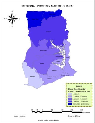
REGIONAL POVERTY MAP OF GHANA
- 1. Northern Volta Ashanti Western Brong Ahafo Upper West Eastern Central Upper East Eastern Greater Accra Volta Brong Ahafo REGIONAL POVERTY MAP OF GHANA ® Author: Selase Wilmot Kwami 90 0 90 180 270 36045 Kilometers 1 cm = 40 km Legend Ghana_Reg_Boundary POVERTY as Percent of Total 1.136364% 1.136365% - 5.681818% 5.681819% - 7.954545% 7.954546% - 17.045455% 17.045456% - 21.590909% Date: 11/4/2016