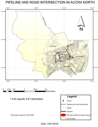
This document provides a map and legend showing the intersection of pipelines and roads in Accra North, Ghana. The map displays towns, roads, pipelines, and a 60 meter buffer around the pipeline network. An accompanying legend identifies pipelines and road intersections on the map. The date and source are listed at the bottom.
Florida Automotive Service Tools & Equipment, Rotary Bend Pak Ammco Coats, Car Lift Florida, Florida Direct Lift, Rotary Lift. Accu line Tire Changer and Wheel balancer.
Automotive equipment
Florida Automotive Service Tools & Equipment, Rotary Bend Pak Ammco Coats, Car Lift Florida, Florida Direct Lift, Rotary Lift. Accu line Tire Changer and Wheel balancer.
Automotive equipment
1. XYXY
XY
XY
XY
XY
XY
XY
Accra North
W
inneba
Road
KandaHighRoadLaRoad
Accra - Tema Motorway
Blair Street
NsawamRoad
Flo
O
yeo
Road
Eastloop
Dome
Abofu
Israel
Soutuom
Achimota
Golden Door
Azuma Nelson
Tabora Alhaji
0°10'0"W
0°10'0"W
0°15'0"W
0°15'0"W
0°20'0"W
0°20'0"W
0°25'0"W
0°25'0"W
5°45'0"N 5°45'0"N
5°40'0"N 5°40'0"N
5°35'0"N 5°35'0"N
PIPELINE AND ROAD INTERSECTION IN ACCRA NORTH
Legend
XY Towns
Pipeline and road intersection
Roads
Pipeline
60 meter buffer from pipe network
Accra North
´
0 3.5 7 10.5 141.75
Kilometers
Date: 10/21/2016
1 inch equals 3.81 kilometers
All rights reserved: GIS TEAMC