Point Clouds Bim Transformed into As-Builts Drawings.pdf
•
0 likes•3 views

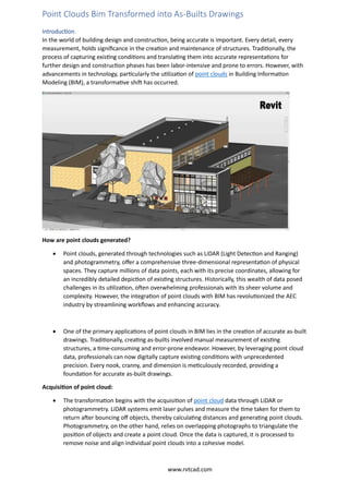
In the world of building design and construction, being accurate is important. Every detail, every measurement, holds significance in the creation and maintenance of structures. Traditionally, the process of capturing existing conditions and translating them into accurate representations for further design and construction phases has been labor-intensive and prone to errors. However, with advancements in technology, particularly the utilization of point clouds in Building Information Modeling (BIM), a transformative shift has occurred.

Recommended
Recommended
More Related Content
Similar to Point Clouds Bim Transformed into As-Builts Drawings.pdf
Similar to Point Clouds Bim Transformed into As-Builts Drawings.pdf (20)
Recently uploaded
Recently uploaded (20)
Point Clouds Bim Transformed into As-Builts Drawings.pdf
- 1. Point Clouds Bim Transformed into As-Builts Drawings Introduction: In the world of building design and construction, being accurate is important. Every detail, every measurement, holds significance in the creation and maintenance of structures. Traditionally, the process of capturing existing conditions and translating them into accurate representations for further design and construction phases has been labor-intensive and prone to errors. However, with advancements in technology, particularly the utilization of point clouds in Building Information Modeling (BIM), a transformative shift has occurred. How are point clouds generated? • Point clouds, generated through technologies such as LiDAR (Light Detection and Ranging) and photogrammetry, offer a comprehensive three-dimensional representation of physical spaces. They capture millions of data points, each with its precise coordinates, allowing for an incredibly detailed depiction of existing structures. Historically, this wealth of data posed challenges in its utilization, often overwhelming professionals with its sheer volume and complexity. However, the integration of point clouds with BIM has revolutionized the AEC industry by streamlining workflows and enhancing accuracy. • One of the primary applications of point clouds in BIM lies in the creation of accurate as-built drawings. Traditionally, creating as-builts involved manual measurement of existing structures, a time-consuming and error-prone endeavor. However, by leveraging point cloud data, professionals can now digitally capture existing conditions with unprecedented precision. Every nook, cranny, and dimension is meticulously recorded, providing a foundation for accurate as-built drawings. Acquisition of point cloud: • The transformation begins with the acquisition of point cloud data through LiDAR or photogrammetry. LiDAR systems emit laser pulses and measure the time taken for them to return after bouncing off objects, thereby calculating distances and generating point clouds. Photogrammetry, on the other hand, relies on overlapping photographs to triangulate the position of objects and create a point cloud. Once the data is captured, it is processed to remove noise and align individual point clouds into a cohesive model. www.rvtcad.com
- 2. • With the point cloud data processed and aligned, the next step is to extract meaningful information from it. This involves segmenting the point cloud to identify individual elements such as walls, floors, and structural components. Advanced algorithms and software facilitate this process, automatically recognizing patterns and shapes within the point cloud data. Once segmented, the point cloud can be used as a reference to create precise 3D models of existing structures. Integration of point cloud with BIM: The integration of point clouds with BIM software further enhances their utility in creating as-built drawings. BIM platforms enable professionals to overlay point cloud data with existing design models, facilitating comparison and analysis. This integration allows for a seamless transition from capturing existing conditions to incorporating them into the design process. Design changes can be made with confidence, knowing they are based on accurate representations of the existing structure. Accuracy: Moreover, point clouds offer a level of detail and accuracy that surpasses traditional surveying methods. They capture not only geometric dimensions but also nuances such as surface textures and irregularities. This level of fidelity ensures that as-built drawings are not just accurate but also reflective of the true character of the structure. Whether it's capturing the intricate ornamentation of a historic building or the complex geometry of a modern architectural marvel, point clouds deliver a level of detail that was previously unattainable. Benefits of utilizing point cloud in as-built drawings: The benefits of utilizing point clouds in creating as-built drawings extend beyond accuracy. They also offer significant time and cost savings compared to traditional methods. By streamlining the data capture process and eliminating the need for manual measurements, professionals can expedite project timelines and reduce labor costs. Furthermore, the digital nature of point cloud data allows for easy sharing and collaboration among project stakeholders, fostering greater efficiency and communication. Conclusion: In conclusion, the integration of point clouds with BIM has transformed the creation of as-built drawings in the AEC industry. What was once a labor-intensive and error-prone process has now become streamlined, efficient, and highly accurate. Point clouds offer a wealth of data that, when leveraged effectively, provide a foundation for precise and detailed representations of existing structures. As technology continues to advance, the marriage of point clouds and BIM promises to revolutionize further the way we design, construct, and maintain the built environment. www.rvtcad.com