This document provides forecasts for wind speeds and wave heights in the Northeast Pacific region over the next 72 hours. It warns of Tropical Depression One-E located near 11.0N 110.4W, which is forecast to strengthen into a hurricane over the period. Wind speeds up to 85 knots and wave heights up to 22 feet are expected within 270 nautical miles of the storm's center. Other areas are forecast to see winds of 20 knots or less and wave heights below 8 feet.
Atlantic Remnants of HANNA Forecast/Advisory Number 8newsmiami
This advisory from the National Hurricane Center discusses the remnants of Hurricane Hanna. The government of Honduras has discontinued the tropical storm warning for its coast. The advisory provides the location and estimated strength of the remnants, with maximum sustained winds of 30 knots and gusts up to 40 knots, centered near 14.5N 84.5W. The forecast calls for the system to dissipate by 29/0000Z.
Atlantic Remnants of HANNA Forecast/Advisory Number 8newsmiami
This advisory from the National Hurricane Center discusses the remnants of Hurricane Hanna over Central America. The government of Honduras has discontinued the tropical storm warning for its coast. The advisory provides the location and estimated strength of the remnants, with maximum sustained winds of 30 knots and gusts up to 40 knots. This is the last advisory to be issued on this system by the NHC.
Nws chs ron morales - cema hur conf 2010Chatham EMA
The document summarizes changes to National Hurricane Center products for the 2010 hurricane season, including shorter lead times for issuing watches and warnings, a new public advisory format with key information presented first, and explicit probabilities included in tropical weather outlooks. It also discusses the all-new Saffir-Simpson scale, a slight reduction in the size of forecast cones, and notes that while the official hurricane season outlook is not yet available, above-normal activity is expected due to warm Atlantic waters and a weakening El Nino.
The document provides wind speed probability data for Tropical Depression ANA over the next 5 days for various locations along the Atlantic coast. It gives the chances of sustained wind speeds reaching or exceeding 34, 50, and 64 knots at each location between May 10-15, 2015. Probabilities are provided as onset and cumulative percentages for 6-hour time periods over the forecast period.
Tropical Storm Ana made landfall along the South Carolina coast between Myrtle Beach and North Myrtle Beach at 6:00 AM EDT on May 10, 2015, with maximum sustained winds of 45 MPH. The storm was located about 5 miles northeast of Myrtle Beach and 10 miles southwest of North Myrtle Beach, moving northwest at 5 MPH.
The page requested could not be found and the user received a 404 error. Possible reasons for this include typing the URL incorrectly or a broken link. The user is advised to visit the homepage, search relevant subjects, or use the site search to find what they are looking for.
Tropical Storm Hanna was located along the coast of northeastern Nicaragua as of 1200 PM EDT on October 27, 2014. It was about 15 miles west-southwest of Cabo Gracias a Dios on the Nicaragua-Honduras border and about 60 miles north of Puerto Cabezas, Nicaragua. Hanna had maximum sustained winds of 40 mph and was moving west at 7 mph.
Atlantic Post-Tropical Cyclone GONZALO Advisory Number 30
NHC East Pacific Tropical Weather Discussion
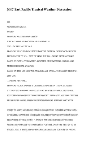
1. NHC East Pacific Tropical Weather Discussion
000
AXPZ20 KNHC 282135
TWDEP
TROPICAL WEATHER DISCUSSION
NWS NATIONAL HURRICANE CENTER MIAMI FL
2205 UTC THU MAY 28 2015
TROPICAL WEATHER DISCUSSION FOR THE EASTERN PACIFIC OCEAN FROM
THE EQUATOR TO 32N...EAST OF 140W. THE FOLLOWING INFORMATION IS
BASED ON SATELLITE IMAGERY...WEATHER OBSERVATIONS...RADAR...AND
METEOROLOGICAL ANALYSIS.
BASED ON 1800 UTC SURFACE ANALYSIS AND SATELLITE IMAGERY THROUGH
2100 UTC.
...SPECIAL FEATURE...
TROPICAL STORM ANDRES IS CENTERED NEAR 11.6N 112.5W AT 28/2100
UTC MOVING W-NW OR 295 DEG AT 10 KT AND THIS GENERAL MOTION IS
EXPECTED TO CONTINUE THROUGH TONIGHT. ESTIMATED MINIMAL CENTRAL
PRESSURE IS 998 MB. MAXIMUM SUSTAINED WIND SPEED IS 50 KT WITH
GUSTS TO 60 KT. NUMEROUS STRONG CONVECTION IS NOTED WITHIN 90 NM
OF CENTER. SCATTERED MODERATE ISOLATED STRONG CONVECTION IS SEEN
ELSEWHERE WITHIN 360 NM N AND 270 NM S SEMICIRCLES OF CENTER.
ANDRES IS FORECAST TO STRENGTHEN FURTHER OVER THE NEXT 24 TO 48
HOURS...AND IS EXPECTED TO BECOME A HURRICANE TONIGHT OR FRIDAY.
2. REFER TO LATEST NHC PUBLIC/FORECAST ADVISORIES UNDER AWIPS/WMO
HEADERS MIATCPEP1/MIATCMEP1 AND WTPZ31/WTPZ21 KNHC FOR MORE
DETAILS.
...TROPICAL WAVES/LOWS...
A TROPICAL WAVE EXTENDS FROM FROM 05-14N ALONG 98W/99W AND HAS
BEEN PROGRESSING W AT 10 KT OVER THE PAST 24 HOURS. CURRENTLY
SCATTERED MODERATE ISOLATED STRONG CONVECTION IS NOTED WITHIN
120 NM W OF AXIS FROM 07N TO 11N. THE WAVE IS FORECAST TO
CONTINUE W TODAY AND GRADUALLY LOSE IDENTITY AS IT BECOMES
ABSORBED INTO THE BROADER CYCLONIC CIRCULATION ASSOCIATED WITH
TROPICAL STORM ANDRES.
A 1008 MB LOW PRES IS ANALYZED NEAR 09N135W WITH SCATTERED
MODERATE ISOLATED STRONG CONVECTION WITHIN 180 NM N SEMICIRCLE
3. OF CENTER. A STRONGER PRESSURE GRADIENT BETWEEN THIS LOW AND
HIGH PRES TO THE N IS MAINTAINING NE-E 20-25 KT TRADES WITHIN
360 NM OF THE N SEMICIRCLE OF CENTER WITH COMBINED SEAS TO 9 FT.
THE LOW IS FORECAST TO CONTINUE W-SW TO NEAR 10N138W FRI AND
NEAR 09N140W ON SAT.
...INTERTROPICAL CONVERGENCE ZONE/MONSOON TROUGH...
CURRENTLY THERE IS NOT A WELL DEFINED MONSOON TROUGH OR ITCZ.
A SURFACE LOW OVER NW COLOMBIA HAS AN ASSOCIATED TRAILING
TROUGH SW ACROSS THE EPAC TO 05N79W TO 03N90W. SCATTERED
MODERATE CONVECTION IS N OF 03N E OF 85W TO THE COAST OF
COLOMBIA.
...DISCUSSION...
A RIDGE/TROUGH PATTERN DOMINATES THE N WATERS WITH THE TROUGH
4. AXIS OVER N-CENTRAL MEXICO. AN UPPER ANTICYCLONE IS CENTERED
OVER THE TROPICS NEAR 14N103W WITH AN UPPER RIDGE EXTENDING
WESTWARD TO BEYOND 10N140W. AN UPPER RIDGE ALSO EXTENDS E TO A
CREST EASTWARD TO 10N90W. THE ASSOCIATED UPPER DIFFLUENCE IS
ENHANCING CONVECTION ASSOCIATED WITH TROPICAL STORM ANDRES AND
PROVIDING A FAVORABLE ENVIRONMENT FOR INTENSIFICATION...REFER TO
THE SPECIAL FEATURES SECTION ABOVE FOR ADDITIONAL INFORMATION ON
ANDRES.
BROAD SURFACE RIDGE ANCHORED BY 1019 MB HIGH PRES CENTERED NEAR
28N130W EXTENDS A RIDGE ACROSS THE NORTH WATERS TO NEAR 21N112W.
THE HIGH PRES IS FORECAST TO REMAIN NEARLY STATIONARY OVER THE
NEXT 24 HOURS. THE PRES GRADIENT BETWEEN THE RIDGE AND LOWER
PRES ACROSS THE TROPICS SUPPORTS AN AREA OF FRESH TO STRONG
TRADE WINDS MAINLY FROM 10N TO 17N W OF 130W...AND FROM 11N TO
15N BETWEEN 120W AND 130W WITH COMBINED SEAS OF 9 FT.
GULF OF TEHUANTEPEC...EXPECT A BRIEF NORTHERLY SURGES TO 20-25
KT AT TIMES OF DIURNALLY DRIVEN DRAINAGE FLOW THROUGH THE NEXT
24 HOURS BEFORE WINDS DROP BELOW 20 KT. SEAS ARE EXPECTED TO
REMAIN BELOW 8 FT THROUGH THE NEXT 48 HOURS. THE PATTERN WILL
REPEAT AGAIN LATE TONIGHT.
$$
GR