
Report
Share
Download to read offline
Recommended
Gravimetri : Ders 12
Gravimetri Dersi için aşağıda ki videoları izleyebilirsiniz.
Link 01: https://www.youtube.com/watch?v=HTyjVaVGx0k
Link 02: https://www.youtube.com/watch?v=fUkfgI8XaOE
Recommended
Gravimetri : Ders 12
Gravimetri Dersi için aşağıda ki videoları izleyebilirsiniz.
Link 01: https://www.youtube.com/watch?v=HTyjVaVGx0k
Link 02: https://www.youtube.com/watch?v=fUkfgI8XaOE
Gravimetri: Ders 05
Gravimetry Ders II. Öğretim Ders Videosu Linki
https://youtu.be/xwNnvRLneWY
Gravimetry Ders I. Öğretim Ders Videosu Linki
https://youtu.be/Tb-Ka1bDuSY
Gravimetri : Ders 04
The document discusses gravity anomalies and density variations in different regions based on gravity data. It shows how gravity maps reveal details about crustal thickness, tectonic features like faults and volcanic zones, and plate boundaries. Specific examples discussed include the Tibetan Plateau, Central America subduction zone, an area in Chugoku, Japan, and the state of Florida in the US. Regional gravity data can be used to model density changes associated with plate tectonics, crustal evolution, and volcanic and tectonic activity.
Kar Kar Geothermal Field Work
The USF team reviewed a geophysical investigation of the Kar Kar region conducted by WesternGeco in 2011. They found that WesternGeco's magnetotelluric (MT) data and models were of high quality. Both the WesternGeco and USF MT models identified a low resistivity zone at 300m depth that correlates with a water-bearing zone found in Borehole 4. USF performed gravity modeling which identified a north-south trending basin reaching 1500m depth, consistent with mapped faults. A preliminary hydrothermal model suggested observed temperatures could result from deep circulation of meteoric waters in the basin without needing a localized heat source. Additional geophysical data is recommended around the Jermaghbyur hot springs to
Beppu geothermal field
This document summarizes a study that used gravity data to delineate underground structure in the Beppu geothermal field in Japan. Analysis of Bouguer anomaly maps revealed high anomalies in the southern and northern parts of the study area that correspond to known geological formations. Edge detection filtering of the gravity data helped identify subsurface faults, including the northern edge of the high southern anomaly corresponding to the Asamigawa Fault. Depth modeling of the gravity basement showed differences between the southern and northern hot spring areas, with steep basement slopes along faults in the south and uplifted basement in the north.
High Resolution Earth's Gravitational Field
This document summarizes the development of a new ultra-high resolution model of Earth's gravity field called GGMplus. Key points:
- GGMplus combines satellite gravity data from GOCE and GRACE with terrestrial gravity data and topography to achieve unprecedented 200m spatial resolution globally.
- It provides gridded estimates of gravity, horizontal and radial field components, and quasi-geoid heights at over 3 billion points covering 80% of the Earth's land.
- GGMplus reveals new details of small-scale gravity variations and identifies locations of minimum and maximum gravity, suggesting peak-to-peak variations are 40% larger than previous estimates. The model will benefit scientific and engineering applications.
Gravity Predictions for Earthquakes
Gravity measurements were taken in a region of China covering the south-north earthquake belt in 1998, 2000, 2002, and 2005. Researchers noticed significant gravity changes in the region surrounding Wenchuan and suggested in 2006 that a major earthquake could occur there in 2007 or 2008. While gravity changes were significant at some locations, more research is needed to determine if they could be considered a precursor. Uncertainties exist from measurement errors, hydrologic effects, and crustal movements. Improved data collection and analysis could enhance using gravity monitoring for earthquake research.
Nakamura Technique for Soil Characterization
Multidisipliner Jeofizik Yöntemler, deprem güvenli jeofizik 'fiziksel zeminleri' çok net ortaya çıkarıyor.
H/V User Guidelines
The document provides guidelines for implementing the H/V spectral ratio technique using ambient vibration measurements to evaluate site effects. It recommends procedures for experimental design, data processing, and interpretation. The key recommendations include measuring for sufficient duration depending on expected frequency, using multiple measurement points, avoiding disturbances, and interpreting H/V peaks in context with geological and geophysical data. Reliable H/V peaks are defined as having a clear maximum within expected frequency ranges and uncertainties. The guidelines aim to help apply the technique while accounting for its limitations.
Geopsy: Seismic Vibration Processing
Geopsy yaygın olarak kullanılan profesyonel bir program. Özellikle, profesyonel program deneyimi yeni mezunlarda çok aranan bir özellik. Bir öğrencim çalışmasında kullanmayı planlıyor.
M6.0 2004 Parkfield Earthquake : Seismic Attenuation
HRSN isimli kuyu içi sismik istasyonlar kullanılarak, San Andreas fayı boyunca meydana gelen büyük depremler öncesi sismik azalımın varlığının olup olmadığı araştırılıyor.
Deprem Verilerinin H/V Oranının Mevsimsel Değişimi
H/V oranının zaman içinde değişimi konusu bana oldukça ilginç gelmişti ve bu tür bir çalışma yapıldı mı sorusunu netleştirmek için araştırma yaptım ve 2021 yılında bu konuda GJI gibi bir dergide yayınlanmış bir çalışma buldum. Bu çalışma oldukça iyi bir referans H/V çalışmaları için. Önemli referans düşünceler şöyle; 1) Mevsimsel olarak yağışa bağlı olarak yeraltı kaynaklarında ki azalma ve yükselmeye bağlı olarak H/V yükseliyor, 2) H/V pik değerleri kaya zemin üzerinde yaklaşık BİR (1) oranında seyreder ve PİK vermezken, kaya zeminden uzaklaşıldıkça zemin etkisi ile PİK değerleri değişir, 3) Deprem ve Gürültü sinyallerinden hesap edilen F(PİK) nerede ise sabitken, H/V oranları %10 değişir, 4) M6.8 büyüklüğünde meydana gelen bir deprem H/V değişimlerini etkiler.
Yapılan çalışmada kullanılan yaklaşım SESAME (2004) kriterlerine uygun olarak 1) 60 dakikalık veriler analizi, 2) 1000 günden fazla gözlem süresi 3) 10'dan fazla farklı zeminlerde istasyon 4) 60 dakikalık birbirinden ayrı verilerin analiz edilmesi. Oldukça emek yoğun bir çalışma
The first earthquake site assessments in alberta canada
This document is a thesis that investigates site characterization and earthquake site amplification in Alberta, Canada. It includes two studies as chapters: 1) A study using non-invasive techniques like microtremor surveys to characterize seismic stations in Alberta based on shear-wave velocity profiles. Shear-wave velocity was found to be generally low, limiting sites to National Building Code classes C and D. 2) A study characterizing earthquake site amplification in Alberta by analyzing horizontal-to-vertical spectral ratios from earthquakes and microtremors. Softer surficial geology was found to correlate with larger amplification. Empirical amplification functions were derived that can be correlated to surficial geology. Peak frequencies were generally low (<10 Hz) indicating deep
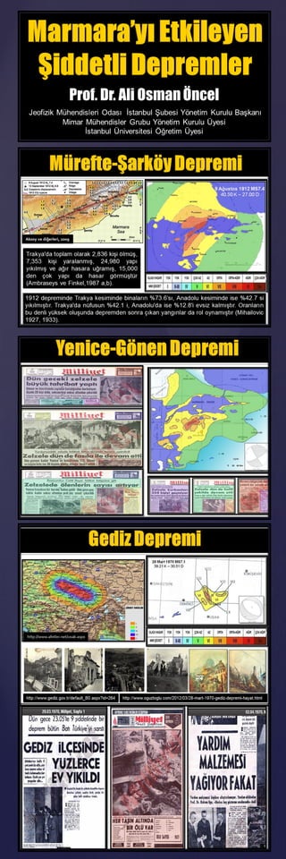
OBS Seismicity Monitoring in Marmara
1) Long-term ocean bottom seismograph observations in the Marmara Sea identified changes in seismic activity and fault geometry along the Main Marmara Fault.
2) The maximum focal depth was 26 km beneath the Western High, but events were confined to the upper crust further east.
3) An abrupt change in fault dip and the depth of the seismogenic zone indicates a segment boundary beneath the Central Basin.
4) Seismicity locates beneath the sedimentary basement. Inactive zones within the upper crust may indicate locked sections accumulating stress.
Seismic Risk in Marmara
Marmara ve İstanbul için ayrı ayrı 2 senaryo yapılmış. Coulomb Stress etkisi önemli ölçüde deprem olasılığını yükseltiyor. Özellikle, KAFZ boyunca meydana gelen depremlerin yüzey kırıklarının Dünya'da ki benzer büyük depremlerin yüzey kırıklarından oldukça farklı ve büyük.
Gaz ve Deprem İlişkisi: İstanbul Deprem Boşluğu
This document summarizes research showing that many aftershocks from a 2011 M5.1 earthquake in the Sea of Marmara occurred within a zone of gas overpressuring between 1.5-5 km depth, where pressurized gas is expected to migrate along the Main Marmara Fault and up to seafloor sediments. This suggests gas-related processes should be considered when interpreting micro-seismicity (M<3) in the Istanbul offshore domain, not just tectonic processes. Improved earthquake locations found many aftershocks occurred at shallow depths within areas of known gas seeps, challenging the view that seismicity is solely tectonically driven in this region.
Bölgesel Depremsellik: Doğu Anadolu Fay Zonu
İstasyon dağılımı çift kanaldan yapılıyor ve bu kanallar AFAD ve KOERI. İlginç olan durum bu istasyonlar 1 YIL içinde yerleştirilmiyor ve YILLARA yayılan bir yerleştirme planı var. İstatistik çalışanlar için iyi özellikle, 'İstasyon Etkilerinin Sismisite Değişimine Muhtemel Etkileri' konusunu çalışmak isteyenler için. Özellikle, 1995 yılında ki çalışmam bununla ilişkili. https://npg.copernicus.org/articles/2/147/1995/
AFAD tarafından DAFZ civarında kurulmuş 28 istasyonu var ve 2006 yılında kurmaya başlamış ve süreç 2017 yılına kadar yükselerek devam etmiş. 2006 yılında 28 istasyonun tamamını 1 DEFA'da kurmuş olsa idi fay zonlarının deprem tehlikesinin araştırılması için önemli bir VERİ toplanması olacaktı ve bugüne kadar 15 yıllık veri üzerinde '0-İnsan Etkisi' olduğundan istatistik çalışmalar ile bulunan sonuçlar anlamlı olacaktı. Sıkça sorulan soru vardır, 'Depremler son yıllarda sayısal olarak artıyor mu?' diye, EVET artıyor çünkü depremi kayıt eden İSTASYON sayısı arttığı için. Bu açıdan, 'İnsana bağlı olarak deprem tehlike verisinde ki değişim' araştırma konusu olur mu? Neden olmasın!
Benzer durum KOERI'de var ve 2006 yılında 5 olan istasyon sayısını 2011 yılına kadar tedrici olarak 10 sayısına yükseltiyor. 2011 yılından sonra sayı 12'de sabit kalıyor.
2006 yılından günümüze DAFZ üzerinde İKİLİ KURUM tarafından kurulan toplam istasyon sayısı 40, fakat bunlar TEK 1 YILDA kurulmadığı için İSTATİSTİK çalışmalara ETKİSİ olumsuz. 2006 yılında 40 istasyon 1 DEFADA kurulsa idi, DAFZ boyunca fayların deprem potansiyelinin araştırılması açısından ÇOK İYİ bir potansiyel olacaktı.
Deprem İstatistiği çalışmalarında DİKKAT edilecek ÇOK noktalar var, bu noktalar bölgede ki VERİ KAPASİTESİ ve VERİ KALİTESİ'nin iyi araştırılması ile mümkün olur. Aslında burada ANLATILANLARI İstatistiksel Sismoloji dersinde detaylı tartıştım. Deprem İstatistiği çalışacak olan ve bu konuda çalışmak isteyenler bu dersler BAŞTAN SONA not alarak 1 KERE daha dinlese İYİ olur. AKSİ taktirde çalışmalarınız İYİ 1 BİLİMSEL TEMELE dayanmazsa çok yararsız olabilir.
Seismic Risk in SE Turkey
Türkiye'nin doğusunda en büyük tehlike kaynaklarından birisi SINIR ZONU olarak görünüyor. Bölgede ki en güvenilir tarihsel veri Ambraseys'den geliyor. Büyük sismolog. Ambraseys makaleleri okudukça yeni şeyler keşfedilen makaleler. Türkiye'de Sınır Deprem Kuşağını çok net göstermiş.
More Related Content
More from Ali Osman Öncel
Gravimetri: Ders 05
Gravimetry Ders II. Öğretim Ders Videosu Linki
https://youtu.be/xwNnvRLneWY
Gravimetry Ders I. Öğretim Ders Videosu Linki
https://youtu.be/Tb-Ka1bDuSY
Gravimetri : Ders 04
The document discusses gravity anomalies and density variations in different regions based on gravity data. It shows how gravity maps reveal details about crustal thickness, tectonic features like faults and volcanic zones, and plate boundaries. Specific examples discussed include the Tibetan Plateau, Central America subduction zone, an area in Chugoku, Japan, and the state of Florida in the US. Regional gravity data can be used to model density changes associated with plate tectonics, crustal evolution, and volcanic and tectonic activity.
Kar Kar Geothermal Field Work
The USF team reviewed a geophysical investigation of the Kar Kar region conducted by WesternGeco in 2011. They found that WesternGeco's magnetotelluric (MT) data and models were of high quality. Both the WesternGeco and USF MT models identified a low resistivity zone at 300m depth that correlates with a water-bearing zone found in Borehole 4. USF performed gravity modeling which identified a north-south trending basin reaching 1500m depth, consistent with mapped faults. A preliminary hydrothermal model suggested observed temperatures could result from deep circulation of meteoric waters in the basin without needing a localized heat source. Additional geophysical data is recommended around the Jermaghbyur hot springs to
Beppu geothermal field
This document summarizes a study that used gravity data to delineate underground structure in the Beppu geothermal field in Japan. Analysis of Bouguer anomaly maps revealed high anomalies in the southern and northern parts of the study area that correspond to known geological formations. Edge detection filtering of the gravity data helped identify subsurface faults, including the northern edge of the high southern anomaly corresponding to the Asamigawa Fault. Depth modeling of the gravity basement showed differences between the southern and northern hot spring areas, with steep basement slopes along faults in the south and uplifted basement in the north.
High Resolution Earth's Gravitational Field
This document summarizes the development of a new ultra-high resolution model of Earth's gravity field called GGMplus. Key points:
- GGMplus combines satellite gravity data from GOCE and GRACE with terrestrial gravity data and topography to achieve unprecedented 200m spatial resolution globally.
- It provides gridded estimates of gravity, horizontal and radial field components, and quasi-geoid heights at over 3 billion points covering 80% of the Earth's land.
- GGMplus reveals new details of small-scale gravity variations and identifies locations of minimum and maximum gravity, suggesting peak-to-peak variations are 40% larger than previous estimates. The model will benefit scientific and engineering applications.
Gravity Predictions for Earthquakes
Gravity measurements were taken in a region of China covering the south-north earthquake belt in 1998, 2000, 2002, and 2005. Researchers noticed significant gravity changes in the region surrounding Wenchuan and suggested in 2006 that a major earthquake could occur there in 2007 or 2008. While gravity changes were significant at some locations, more research is needed to determine if they could be considered a precursor. Uncertainties exist from measurement errors, hydrologic effects, and crustal movements. Improved data collection and analysis could enhance using gravity monitoring for earthquake research.
Nakamura Technique for Soil Characterization
Multidisipliner Jeofizik Yöntemler, deprem güvenli jeofizik 'fiziksel zeminleri' çok net ortaya çıkarıyor.
H/V User Guidelines
The document provides guidelines for implementing the H/V spectral ratio technique using ambient vibration measurements to evaluate site effects. It recommends procedures for experimental design, data processing, and interpretation. The key recommendations include measuring for sufficient duration depending on expected frequency, using multiple measurement points, avoiding disturbances, and interpreting H/V peaks in context with geological and geophysical data. Reliable H/V peaks are defined as having a clear maximum within expected frequency ranges and uncertainties. The guidelines aim to help apply the technique while accounting for its limitations.
Geopsy: Seismic Vibration Processing
Geopsy yaygın olarak kullanılan profesyonel bir program. Özellikle, profesyonel program deneyimi yeni mezunlarda çok aranan bir özellik. Bir öğrencim çalışmasında kullanmayı planlıyor.
M6.0 2004 Parkfield Earthquake : Seismic Attenuation
HRSN isimli kuyu içi sismik istasyonlar kullanılarak, San Andreas fayı boyunca meydana gelen büyük depremler öncesi sismik azalımın varlığının olup olmadığı araştırılıyor.
Deprem Verilerinin H/V Oranının Mevsimsel Değişimi
H/V oranının zaman içinde değişimi konusu bana oldukça ilginç gelmişti ve bu tür bir çalışma yapıldı mı sorusunu netleştirmek için araştırma yaptım ve 2021 yılında bu konuda GJI gibi bir dergide yayınlanmış bir çalışma buldum. Bu çalışma oldukça iyi bir referans H/V çalışmaları için. Önemli referans düşünceler şöyle; 1) Mevsimsel olarak yağışa bağlı olarak yeraltı kaynaklarında ki azalma ve yükselmeye bağlı olarak H/V yükseliyor, 2) H/V pik değerleri kaya zemin üzerinde yaklaşık BİR (1) oranında seyreder ve PİK vermezken, kaya zeminden uzaklaşıldıkça zemin etkisi ile PİK değerleri değişir, 3) Deprem ve Gürültü sinyallerinden hesap edilen F(PİK) nerede ise sabitken, H/V oranları %10 değişir, 4) M6.8 büyüklüğünde meydana gelen bir deprem H/V değişimlerini etkiler.
Yapılan çalışmada kullanılan yaklaşım SESAME (2004) kriterlerine uygun olarak 1) 60 dakikalık veriler analizi, 2) 1000 günden fazla gözlem süresi 3) 10'dan fazla farklı zeminlerde istasyon 4) 60 dakikalık birbirinden ayrı verilerin analiz edilmesi. Oldukça emek yoğun bir çalışma
The first earthquake site assessments in alberta canada
This document is a thesis that investigates site characterization and earthquake site amplification in Alberta, Canada. It includes two studies as chapters: 1) A study using non-invasive techniques like microtremor surveys to characterize seismic stations in Alberta based on shear-wave velocity profiles. Shear-wave velocity was found to be generally low, limiting sites to National Building Code classes C and D. 2) A study characterizing earthquake site amplification in Alberta by analyzing horizontal-to-vertical spectral ratios from earthquakes and microtremors. Softer surficial geology was found to correlate with larger amplification. Empirical amplification functions were derived that can be correlated to surficial geology. Peak frequencies were generally low (<10 Hz) indicating deep
OBS Seismicity Monitoring in Marmara
1) Long-term ocean bottom seismograph observations in the Marmara Sea identified changes in seismic activity and fault geometry along the Main Marmara Fault.
2) The maximum focal depth was 26 km beneath the Western High, but events were confined to the upper crust further east.
3) An abrupt change in fault dip and the depth of the seismogenic zone indicates a segment boundary beneath the Central Basin.
4) Seismicity locates beneath the sedimentary basement. Inactive zones within the upper crust may indicate locked sections accumulating stress.
Seismic Risk in Marmara
Marmara ve İstanbul için ayrı ayrı 2 senaryo yapılmış. Coulomb Stress etkisi önemli ölçüde deprem olasılığını yükseltiyor. Özellikle, KAFZ boyunca meydana gelen depremlerin yüzey kırıklarının Dünya'da ki benzer büyük depremlerin yüzey kırıklarından oldukça farklı ve büyük.
Gaz ve Deprem İlişkisi: İstanbul Deprem Boşluğu
This document summarizes research showing that many aftershocks from a 2011 M5.1 earthquake in the Sea of Marmara occurred within a zone of gas overpressuring between 1.5-5 km depth, where pressurized gas is expected to migrate along the Main Marmara Fault and up to seafloor sediments. This suggests gas-related processes should be considered when interpreting micro-seismicity (M<3) in the Istanbul offshore domain, not just tectonic processes. Improved earthquake locations found many aftershocks occurred at shallow depths within areas of known gas seeps, challenging the view that seismicity is solely tectonically driven in this region.
Bölgesel Depremsellik: Doğu Anadolu Fay Zonu
İstasyon dağılımı çift kanaldan yapılıyor ve bu kanallar AFAD ve KOERI. İlginç olan durum bu istasyonlar 1 YIL içinde yerleştirilmiyor ve YILLARA yayılan bir yerleştirme planı var. İstatistik çalışanlar için iyi özellikle, 'İstasyon Etkilerinin Sismisite Değişimine Muhtemel Etkileri' konusunu çalışmak isteyenler için. Özellikle, 1995 yılında ki çalışmam bununla ilişkili. https://npg.copernicus.org/articles/2/147/1995/
AFAD tarafından DAFZ civarında kurulmuş 28 istasyonu var ve 2006 yılında kurmaya başlamış ve süreç 2017 yılına kadar yükselerek devam etmiş. 2006 yılında 28 istasyonun tamamını 1 DEFA'da kurmuş olsa idi fay zonlarının deprem tehlikesinin araştırılması için önemli bir VERİ toplanması olacaktı ve bugüne kadar 15 yıllık veri üzerinde '0-İnsan Etkisi' olduğundan istatistik çalışmalar ile bulunan sonuçlar anlamlı olacaktı. Sıkça sorulan soru vardır, 'Depremler son yıllarda sayısal olarak artıyor mu?' diye, EVET artıyor çünkü depremi kayıt eden İSTASYON sayısı arttığı için. Bu açıdan, 'İnsana bağlı olarak deprem tehlike verisinde ki değişim' araştırma konusu olur mu? Neden olmasın!
Benzer durum KOERI'de var ve 2006 yılında 5 olan istasyon sayısını 2011 yılına kadar tedrici olarak 10 sayısına yükseltiyor. 2011 yılından sonra sayı 12'de sabit kalıyor.
2006 yılından günümüze DAFZ üzerinde İKİLİ KURUM tarafından kurulan toplam istasyon sayısı 40, fakat bunlar TEK 1 YILDA kurulmadığı için İSTATİSTİK çalışmalara ETKİSİ olumsuz. 2006 yılında 40 istasyon 1 DEFADA kurulsa idi, DAFZ boyunca fayların deprem potansiyelinin araştırılması açısından ÇOK İYİ bir potansiyel olacaktı.
Deprem İstatistiği çalışmalarında DİKKAT edilecek ÇOK noktalar var, bu noktalar bölgede ki VERİ KAPASİTESİ ve VERİ KALİTESİ'nin iyi araştırılması ile mümkün olur. Aslında burada ANLATILANLARI İstatistiksel Sismoloji dersinde detaylı tartıştım. Deprem İstatistiği çalışacak olan ve bu konuda çalışmak isteyenler bu dersler BAŞTAN SONA not alarak 1 KERE daha dinlese İYİ olur. AKSİ taktirde çalışmalarınız İYİ 1 BİLİMSEL TEMELE dayanmazsa çok yararsız olabilir.
Seismic Risk in SE Turkey
Türkiye'nin doğusunda en büyük tehlike kaynaklarından birisi SINIR ZONU olarak görünüyor. Bölgede ki en güvenilir tarihsel veri Ambraseys'den geliyor. Büyük sismolog. Ambraseys makaleleri okudukça yeni şeyler keşfedilen makaleler. Türkiye'de Sınır Deprem Kuşağını çok net göstermiş.
More from Ali Osman Öncel (20)
M6.0 2004 Parkfield Earthquake : Seismic Attenuation
M6.0 2004 Parkfield Earthquake : Seismic Attenuation
Deprem Verilerinin H/V Oranının Mevsimsel Değişimi
Deprem Verilerinin H/V Oranının Mevsimsel Değişimi
The first earthquake site assessments in alberta canada
The first earthquake site assessments in alberta canada