
Recommended
Recommended
More Related Content
More from SaloniKhandelwal49
Recently uploaded
Recently uploaded (20)
City Land Use and Building Typology Map
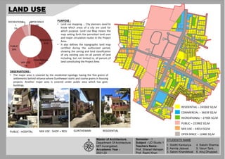
- 1. RESIDENTIAL 41% COMMERCIAL 6% MIX-USE 7% PUBLIC 39% RECREATIONA L 5% OPEN SPACE 2% PURPOSE : • Land use mapping ... City planners need to know which areas of a city are used for which purpose. Land Use Map means the map setting forth the permitted land uses and major circulation routes in the Project Area. • It also defines the topographic land map certified during the authorized period, showing the zoning and land classification of any existing uses on all parcels of land including, but not limited to, all parcels of land constituting the Project Area RESIDENTIAL – 243382 SQ.M COMMERCIAL – 36639 SQ.M RECREATIONAL – 27904 SQ.M PUBLIC – 233982 SQ.M MIX-USE – 44014 SQ.M OPEN SPACE – 12480 SQ.M OBSERVATIONS : • The major area is covered by the residential typology having the fine grains of settlements behind reliance where Gunthewari starts and coarse grains in housing projects. Another major area is covered under public area which has govt. buildings. PUBLIC : HOSPITAL MIX USE : SHOP + RESI GUNTHEWARI RESIDENTIAL
- 2. Attached 19% Detached 44% Semidetached 8% Row House 2% Apartments 27% PURPOSE : • To understand a building's behavior and response to any type of natural or man- made hazard as well as further assists in defining improvement techniques and long-term sustainable regional planning. OBSERVATION : The site contains the major part of detached typology which can be seen in Shanti Niketan colony. Attached typology is mostly observed in Gunthewari area.