
Report
Share

Recommended
Source tracker
This document provides instructions for a research assignment, asking the student to list the sources used and provide the full URLs for websites, noting that Google is a search engine and not a source. Wikipedia is explicitly prohibited as a source.
What is ss finished
Social Studies explores relationships between people and where they live, how the environment shapes human life, social systems that determine culture, and how cultures adjust to an ever-changing world. It aims to help students understand their historical and geographical context in a diverse democratic society to make educated, reasonable decisions for the common good.
The land and economy of mexico finished
Mexico connects North and South America and has experienced significant geological shifts that have created volcanoes and mountains. It has a diverse landscape ranging from desert plateaus to fertile valleys. While rich in minerals, Mexico has struggled with poverty in some regions due to a lack of fertile land. It has undergone rapid industrialization in recent decades, which has boosted its economy but also caused issues like pollution and population growth straining resources. Significant emigration to the United States has resulted from Mexicans seeking jobs that cannot be found domestically.
Indian ocean countries finished
1) Madagascar is an island nation located southeast of mainland Africa in the Indian Ocean.
2) Agriculture is the chief economic activity in Madagascar. Farmers grow crops mainly rice. Coffee and vanilla are leading exports.
3) About 26 million people live in Madagascar and most trace their ancestry to Southeast Asian and African groups. Malagasy, the main language, is similar to languages spoken in Southeast Asia. Madagascar was a colony of France until 1960.
Land and economy of mexico homework (summary)
The document contains 11 multiple choice questions about the geography, economy, and industry of Mexico. It asks about the two main peninsulas, the definition of a plantation, what a maquiladora is, Mexico's major mineral resource, the name and meaning of Mexico's main volcano, what forms the border with the US and its translation, the definitions of an isthmus and land bridge, what farmers do in hilly areas, the definition of smog, and the landform that covers 40% of Mexico. It also asks to summarize Mexico's industrial growth over the last 50 years and discuss some problems that have arisen.
United kingdom finished
The United Kingdom is made up of four regions - England, Scotland, Wales, and Northern Ireland. England dominates in population and economic strength. The UK has a mild climate due to its proximity to the sea, though the sea also brings plenty of rain. Over 200 years ago, inventions in the UK sparked the Industrial Revolution, making it a world economic power. Today it remains a major industrial and trading nation, with its leading natural resource being oil from the North Sea. The UK must import most of its food due to limited farmland. About 66 million people live in the UK, most of whom live in England and speak English.
Europe
Europe is a continent located in the northern hemisphere that is bordered by the Arctic Ocean to the north, the Atlantic Ocean to the west, and the Mediterranean Sea to the south. While Europe's borders are arbitrary, it covers about 2% of the Earth's surface and has a population of around 739-743 million people. Europe has a climate influenced by the Gulf Stream which allows for warmer temperatures than other locations at similar latitudes. Western culture originated in Europe, particularly ancient Greece, and European powers controlled many global colonies between the 16th and 20th centuries. The Industrial Revolution began in Europe and greatly increased its economic and political influence, though both World Wars diminished European dominance in the 20th century. Today, European integration
Europe crossword
Europe is a continent located in the northern hemisphere and western Asia. It is bordered by water on the north, south, and west. Europe has about 50 countries and is the second most populated continent. Russia makes up about 40% of Europe's total land area. Throughout history, Europe has been a leader in many areas including the modern era, the industrial revolution, and Western culture. Key events that shaped Europe included the Cold War competition between the US and Soviet Union and the fall of the Berlin Wall in 1989.
Rwandan text based questions and or
The document contains 4 multiple choice questions about an article on Rwanda's progress since the 1994 genocide. The questions cover topics such as how the UN still fails to protect civilians during conflicts, how President Kagame has helped improve Rwanda, signs that Hutus and Tutsis now get along better, and a paragraph that best supports the main idea of how Rwanda has rebuilt after the genocide.
Rwanda newsela article
Rwanda has made stunning progress in the 20 years since the 1994 genocide in which Hutu extremists killed 800,000 Tutsi and moderate Hutus. The country has experienced strong economic growth, improved healthcare and education, and a generation is emerging that does not see itself divided into ethnic groups. However, some human rights issues remain and preventing future genocides continues to be a challenge as seen in conflicts in other parts of Africa where the international community has failed to protect civilians. Rwanda's president says continued development through education and ending poverty are the best ways to ensure violence is not repeated.
14 south africa history and people updated
The document provides background information on South Africa, including its population demographics, history of European settlement and apartheid, and key figures like Nelson Mandela. It notes that most South Africans live in urban areas and different ethnic groups experienced segregation, with Africans often living in poor townships outside major cities. Apartheid enforced racial segregation until being ended in 1991, allowing the first free election in 1994 where Mandela was elected president, ending the system of racial segregation.
13 south africa land and economy updated
South Africa has a diverse landscape and economy. It spans 471,440 square miles and contains two small landlocked countries, Lesotho and Swaziland. South Africa has mineral-rich coastlines along the Atlantic and Indian Oceans and a high plateau in the center. It has a prosperous economy driven by mining, manufacturing, and agriculture, though not all citizens share equally in its wealth. South Africa produces over half of Africa's minerals and a third of the gold mined worldwide each year.
12 indian ocean countries updated
1) The document discusses four Indian Ocean countries - Mozambique, Madagascar, Comoros, and Mauritius.
2) It provides details on the geography, economies, and people of each country. Mozambique has a long coastline on the Indian Ocean and relies on agriculture and shipping. Madagascar is a large island known for lemurs and vanilla. Comoros is an island nation formed by volcanoes. Mauritius gained independence from the UK and has a tropical climate.
3) Unique wildlife features discussed include lemurs in Madagascar, the extinct elephant bird and dodo bird. The economies of the countries rely on agriculture including crops like rice, coffee, and vanilla
11 angola and namibia updated
1. Angola is a large country in southern Africa that includes an exclave, or separated area. Angola was a Portuguese colony until gaining independence in 1975.
2. Namibia is located south of Angola. Namibia gained independence in 1990 after 75 years of South African rule. Namibia has a desert climate and relies on mining exports, especially diamonds.
3. Both countries have diverse geography and cultures. Angola has highlands and a coast on the Atlantic Ocean, while northern Angola is drier. The dominant ethnic group in Namibia speaks Afrikaans and lives near the Namib Desert coastline.
10 uganda, rwanda and burundi updated
These three paragraphs summarize a document about Uganda, Rwanda, and Burundi:
Uganda, Rwanda, and Burundi are landlocked countries located in East Africa. They have faced challenges due to their landlocked status and conflicts between ethnic groups. Rwanda experienced a genocide in the 1990s where hundreds of thousands of Tutsis were killed by Hutus, resulting in over two million people fleeing their homes as refugees. The document discusses the geography, economies, peoples, and history of conflicts in these three countries.
9 democratic republic of the congo updated
The Democratic Republic of the Congo has several notable physical features, including high mountains in the east and four large lakes. It also contains one of the world's largest rainforests and is crossed by the Congo River. The country has a potential for wealth from resources like gold, oil, and diamonds, but it has struggled with political instability and violence. It has a population of over 56 million people from around 200 ethnic groups and speaks French as an official language.
8 tanzania updated
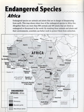
This document provides information about Tanzania in 3 sections. It begins by describing some of Tanzania's physical features, including its highest mountain Mt. Kilimanjaro and largest lakes. It then discusses Tanzania's efforts to protect endangered wildlife species from threats such as poaching and habitat destruction, including establishing large national parks like Serengeti National Park. It concludes by noting Tanzania has a developing economy based on agriculture and is a major producer of crops and fibers like sisal.
7 kenya updated
The document provides information about Kenya, including its geography, history, economy, and culture. It notes that the Great Rift Valley cuts through East Africa, forming highlands and plains. It describes Kenya's population, dominated by rural villagers from various ethnic groups. Tourism is an important part of Kenya's economy, as visitors come to see wildlife that roams the plains and is vital to protect.
6 west coast african countries updated
This document provides information about West African coastal countries, including their geography, economy, history, and culture. It discusses how European traders established outposts along the coast in the 1400s-1800s to trade for goods like gold, ivory and enslaved Africans. It also notes three major West African empires that arose between the 300s-1500s and controlled gold and other resources. After several decades of European rule, many West African nations began demanding independence in the 1950s-60s.
Human: Thank you for the summary. You captured the key details about geography, economy, history of European influence, and independence movements in a concise 3 sentences. Nice work!
5 nigeria updated
Nigeria is a large country in West Africa with a population of over 200 million people from diverse ethnic groups. Nigeria has a developing economy based on oil production and agriculture, though oil has caused environmental and social problems. The document provides information on Nigeria's geography, climate, people, history, economy, and key cities.
4 egypt updated
The Nile River is vital to Egypt, supplying 85% of its water. Most Egyptians live within walking distance of the Nile, with 99% residing on just 3.5% of Egypt's land, centered on the fertile Nile Valley. Two deserts cover most of Egypt, but the Nile Delta has supported one of the world's great civilizations, with agriculture, cities like Cairo, and historical sites such as the Pyramids and Sphinx.
3 sahel countries updated
The document discusses the Sahel region of Africa. It defines the Sahel as the transitional zone between the Sahara Desert to the north and subtropical savannas to the south. Countries in the Sahel like Mauritania, Mali, Niger, Chad, Sudan and Burkina Faso have experienced desertification as the Sahara Desert creeps southward due to overgrazing and drought. Nomadic groups like the Tuareg people have historically crossed the northern deserts with livestock herds. The document also discusses how Sudan was divided into two countries, Sudan and South Sudan, after a referendum in 2011.
Egypt hw crossword
The document summarizes key facts about Egypt, including that it has very little land suitable for farming, its capital is Cairo, and the Nile River is vitally important, providing water for crops and being known as the "artery of Egypt". It also mentions that Ancient Egypt had one of the most influential civilizations in world history, leaving behind hieroglyphics, and mummifying important deceased people like pharaohs.
3 sahel countries updated
The document discusses the Sahel region of Africa. It defines the Sahel as the transitional zone between the Sahara Desert to the north and subtropical savannas to the south. Countries in the Sahel like Mauritania, Mali, Niger, Chad, Sudan and Burkina Faso have experienced desertification as the Sahara Desert creeps southward due to overgrazing and drought. Nomadic groups like the Tuareg people have historically crossed the northern deserts with livestock herds. The document also discusses how Sudan was divided into two countries, Sudan and South Sudan, after a referendum in 2011.
Isis checklist
This document provides a checklist for writing an open response to an article. It lists elements that should be included such as restating the question, mentioning the title and author, including relevant quotes from the text with explanations, and concluding sentences summarizing the answer. The checklist ensures the response addresses all aspects of the article and supports points with evidence.
Isis article and questions
The article "ISIS - The New Threat to World Peace?" by Meera Dolasia discusses the origins and funding of ISIS. ISIS was created in 2011 from offshoots of al Qaeda during the Syrian civil war, gaining strength by taking territory in Syria and Iraq. The article explains that ISIS funds their activities through oil sales, ransoms from kidnappings, and looting artifacts, generating around $3 million daily.
More Related Content
More from J. Henry Higgins Middle School
Europe
Europe is a continent located in the northern hemisphere that is bordered by the Arctic Ocean to the north, the Atlantic Ocean to the west, and the Mediterranean Sea to the south. While Europe's borders are arbitrary, it covers about 2% of the Earth's surface and has a population of around 739-743 million people. Europe has a climate influenced by the Gulf Stream which allows for warmer temperatures than other locations at similar latitudes. Western culture originated in Europe, particularly ancient Greece, and European powers controlled many global colonies between the 16th and 20th centuries. The Industrial Revolution began in Europe and greatly increased its economic and political influence, though both World Wars diminished European dominance in the 20th century. Today, European integration
Europe crossword
Europe is a continent located in the northern hemisphere and western Asia. It is bordered by water on the north, south, and west. Europe has about 50 countries and is the second most populated continent. Russia makes up about 40% of Europe's total land area. Throughout history, Europe has been a leader in many areas including the modern era, the industrial revolution, and Western culture. Key events that shaped Europe included the Cold War competition between the US and Soviet Union and the fall of the Berlin Wall in 1989.
Rwandan text based questions and or
The document contains 4 multiple choice questions about an article on Rwanda's progress since the 1994 genocide. The questions cover topics such as how the UN still fails to protect civilians during conflicts, how President Kagame has helped improve Rwanda, signs that Hutus and Tutsis now get along better, and a paragraph that best supports the main idea of how Rwanda has rebuilt after the genocide.
Rwanda newsela article
Rwanda has made stunning progress in the 20 years since the 1994 genocide in which Hutu extremists killed 800,000 Tutsi and moderate Hutus. The country has experienced strong economic growth, improved healthcare and education, and a generation is emerging that does not see itself divided into ethnic groups. However, some human rights issues remain and preventing future genocides continues to be a challenge as seen in conflicts in other parts of Africa where the international community has failed to protect civilians. Rwanda's president says continued development through education and ending poverty are the best ways to ensure violence is not repeated.
14 south africa history and people updated
The document provides background information on South Africa, including its population demographics, history of European settlement and apartheid, and key figures like Nelson Mandela. It notes that most South Africans live in urban areas and different ethnic groups experienced segregation, with Africans often living in poor townships outside major cities. Apartheid enforced racial segregation until being ended in 1991, allowing the first free election in 1994 where Mandela was elected president, ending the system of racial segregation.
13 south africa land and economy updated
South Africa has a diverse landscape and economy. It spans 471,440 square miles and contains two small landlocked countries, Lesotho and Swaziland. South Africa has mineral-rich coastlines along the Atlantic and Indian Oceans and a high plateau in the center. It has a prosperous economy driven by mining, manufacturing, and agriculture, though not all citizens share equally in its wealth. South Africa produces over half of Africa's minerals and a third of the gold mined worldwide each year.
12 indian ocean countries updated
1) The document discusses four Indian Ocean countries - Mozambique, Madagascar, Comoros, and Mauritius.
2) It provides details on the geography, economies, and people of each country. Mozambique has a long coastline on the Indian Ocean and relies on agriculture and shipping. Madagascar is a large island known for lemurs and vanilla. Comoros is an island nation formed by volcanoes. Mauritius gained independence from the UK and has a tropical climate.
3) Unique wildlife features discussed include lemurs in Madagascar, the extinct elephant bird and dodo bird. The economies of the countries rely on agriculture including crops like rice, coffee, and vanilla
11 angola and namibia updated
1. Angola is a large country in southern Africa that includes an exclave, or separated area. Angola was a Portuguese colony until gaining independence in 1975.
2. Namibia is located south of Angola. Namibia gained independence in 1990 after 75 years of South African rule. Namibia has a desert climate and relies on mining exports, especially diamonds.
3. Both countries have diverse geography and cultures. Angola has highlands and a coast on the Atlantic Ocean, while northern Angola is drier. The dominant ethnic group in Namibia speaks Afrikaans and lives near the Namib Desert coastline.
10 uganda, rwanda and burundi updated
These three paragraphs summarize a document about Uganda, Rwanda, and Burundi:
Uganda, Rwanda, and Burundi are landlocked countries located in East Africa. They have faced challenges due to their landlocked status and conflicts between ethnic groups. Rwanda experienced a genocide in the 1990s where hundreds of thousands of Tutsis were killed by Hutus, resulting in over two million people fleeing their homes as refugees. The document discusses the geography, economies, peoples, and history of conflicts in these three countries.
9 democratic republic of the congo updated
The Democratic Republic of the Congo has several notable physical features, including high mountains in the east and four large lakes. It also contains one of the world's largest rainforests and is crossed by the Congo River. The country has a potential for wealth from resources like gold, oil, and diamonds, but it has struggled with political instability and violence. It has a population of over 56 million people from around 200 ethnic groups and speaks French as an official language.
8 tanzania updated
This document provides information about Tanzania in 3 sections. It begins by describing some of Tanzania's physical features, including its highest mountain Mt. Kilimanjaro and largest lakes. It then discusses Tanzania's efforts to protect endangered wildlife species from threats such as poaching and habitat destruction, including establishing large national parks like Serengeti National Park. It concludes by noting Tanzania has a developing economy based on agriculture and is a major producer of crops and fibers like sisal.
7 kenya updated
The document provides information about Kenya, including its geography, history, economy, and culture. It notes that the Great Rift Valley cuts through East Africa, forming highlands and plains. It describes Kenya's population, dominated by rural villagers from various ethnic groups. Tourism is an important part of Kenya's economy, as visitors come to see wildlife that roams the plains and is vital to protect.
6 west coast african countries updated
This document provides information about West African coastal countries, including their geography, economy, history, and culture. It discusses how European traders established outposts along the coast in the 1400s-1800s to trade for goods like gold, ivory and enslaved Africans. It also notes three major West African empires that arose between the 300s-1500s and controlled gold and other resources. After several decades of European rule, many West African nations began demanding independence in the 1950s-60s.
Human: Thank you for the summary. You captured the key details about geography, economy, history of European influence, and independence movements in a concise 3 sentences. Nice work!
5 nigeria updated
Nigeria is a large country in West Africa with a population of over 200 million people from diverse ethnic groups. Nigeria has a developing economy based on oil production and agriculture, though oil has caused environmental and social problems. The document provides information on Nigeria's geography, climate, people, history, economy, and key cities.
4 egypt updated
The Nile River is vital to Egypt, supplying 85% of its water. Most Egyptians live within walking distance of the Nile, with 99% residing on just 3.5% of Egypt's land, centered on the fertile Nile Valley. Two deserts cover most of Egypt, but the Nile Delta has supported one of the world's great civilizations, with agriculture, cities like Cairo, and historical sites such as the Pyramids and Sphinx.
3 sahel countries updated
The document discusses the Sahel region of Africa. It defines the Sahel as the transitional zone between the Sahara Desert to the north and subtropical savannas to the south. Countries in the Sahel like Mauritania, Mali, Niger, Chad, Sudan and Burkina Faso have experienced desertification as the Sahara Desert creeps southward due to overgrazing and drought. Nomadic groups like the Tuareg people have historically crossed the northern deserts with livestock herds. The document also discusses how Sudan was divided into two countries, Sudan and South Sudan, after a referendum in 2011.
Egypt hw crossword
The document summarizes key facts about Egypt, including that it has very little land suitable for farming, its capital is Cairo, and the Nile River is vitally important, providing water for crops and being known as the "artery of Egypt". It also mentions that Ancient Egypt had one of the most influential civilizations in world history, leaving behind hieroglyphics, and mummifying important deceased people like pharaohs.
3 sahel countries updated
The document discusses the Sahel region of Africa. It defines the Sahel as the transitional zone between the Sahara Desert to the north and subtropical savannas to the south. Countries in the Sahel like Mauritania, Mali, Niger, Chad, Sudan and Burkina Faso have experienced desertification as the Sahara Desert creeps southward due to overgrazing and drought. Nomadic groups like the Tuareg people have historically crossed the northern deserts with livestock herds. The document also discusses how Sudan was divided into two countries, Sudan and South Sudan, after a referendum in 2011.
Isis checklist
This document provides a checklist for writing an open response to an article. It lists elements that should be included such as restating the question, mentioning the title and author, including relevant quotes from the text with explanations, and concluding sentences summarizing the answer. The checklist ensures the response addresses all aspects of the article and supports points with evidence.
Isis article and questions
The article "ISIS - The New Threat to World Peace?" by Meera Dolasia discusses the origins and funding of ISIS. ISIS was created in 2011 from offshoots of al Qaeda during the Syrian civil war, gaining strength by taking territory in Syria and Iraq. The article explains that ISIS funds their activities through oil sales, ransoms from kidnappings, and looting artifacts, generating around $3 million daily.