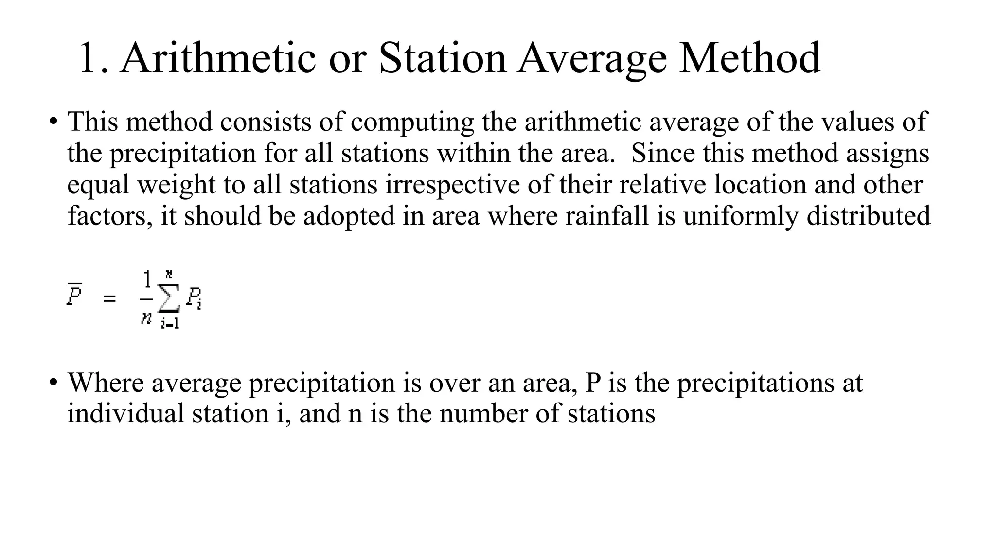
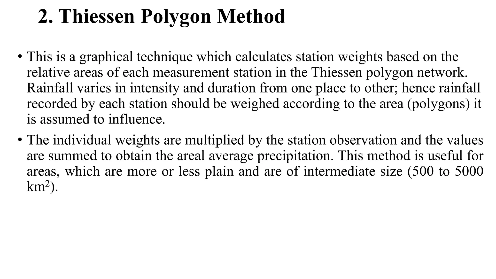
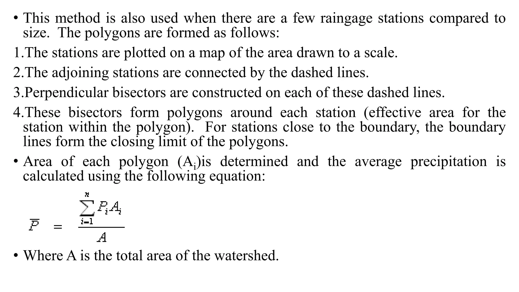
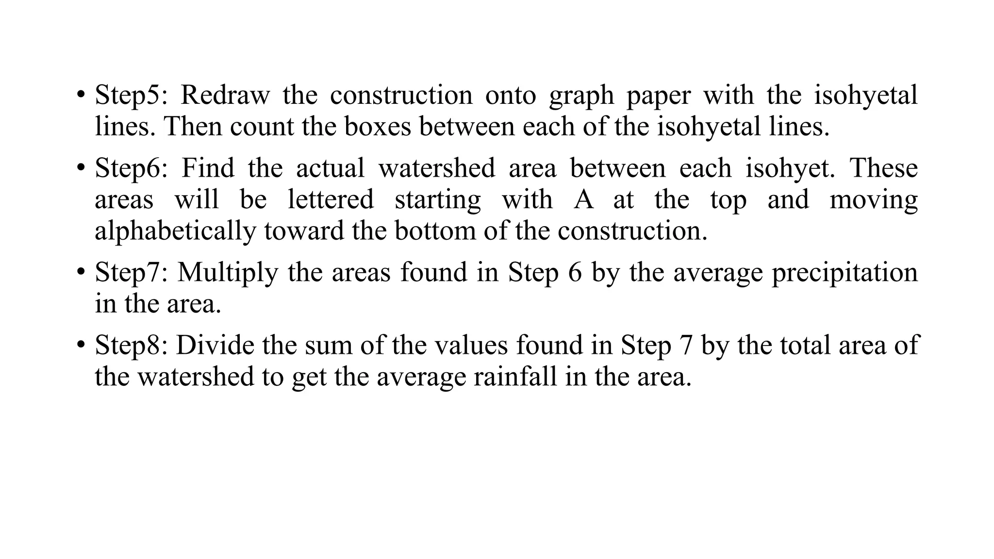
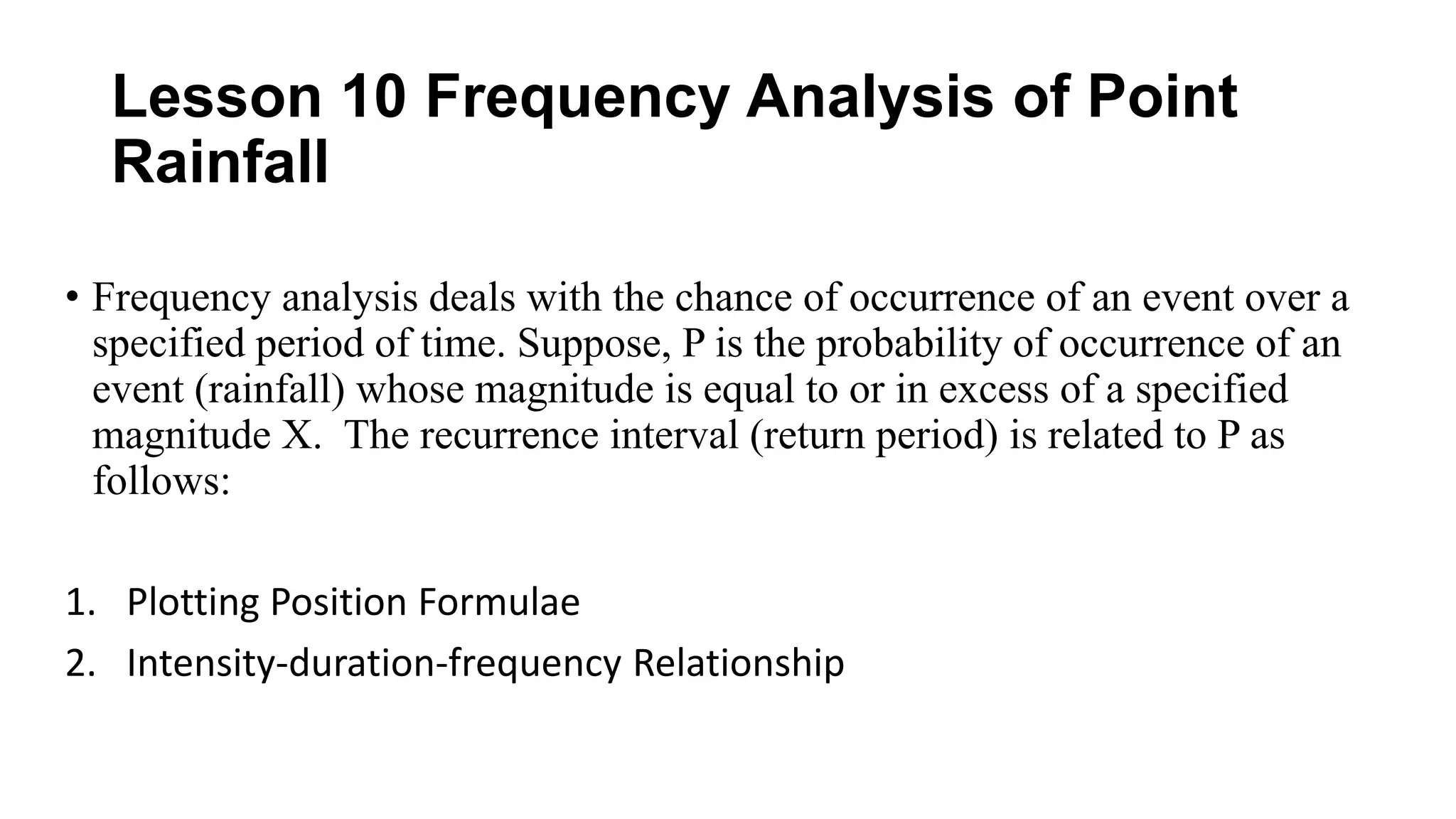
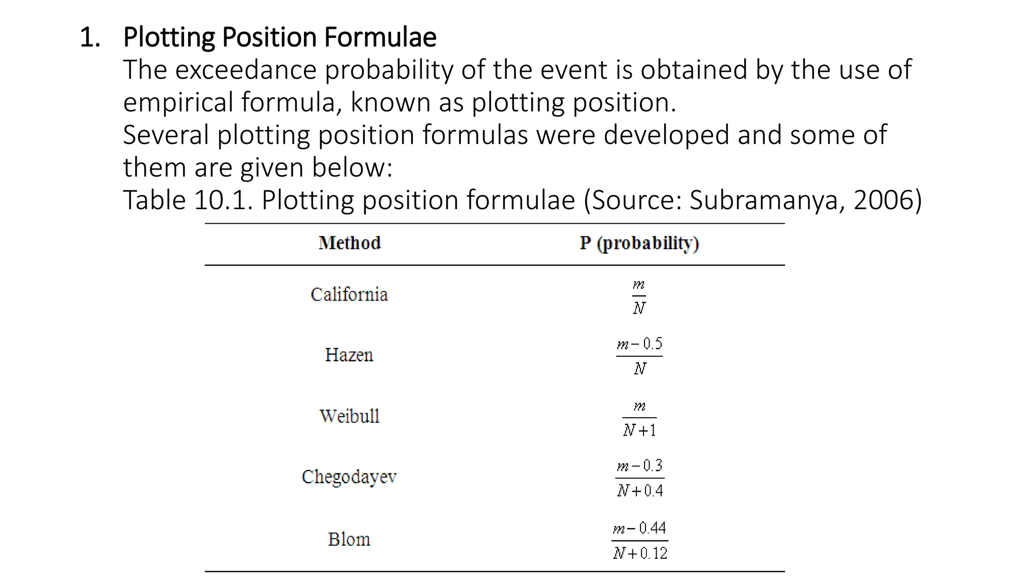
SlideShare a Scribd company logo
1 of 45
HYDROLOGY NOTES
PREPARED
BY
HOPE SUKALI
formulamw@gmail.com
Lesson 9: Estimation of Mean Areal Rainfall
A network of precipitation measurement points can be converted to
areal estimates using any of the following techniques:
1.Arithmetic or Station Average Method
2.Thiessen Polygon Method
3.Isohyetal Method
1. Arithmetic or Station Average Method
โ€ข This method consists of computing the arithmetic average of the values of
the precipitation for all stations within the area. Since this method assigns
equal weight to all stations irrespective of their relative location and other
factors, it should be adopted in area where rainfall is uniformly distributed
โ€ข Where average precipitation is over an area, P is the precipitations at
individual station i, and n is the number of stations
2. Thiessen Polygon Method
โ€ข This is a graphical technique which calculates station weights based on the
relative areas of each measurement station in the Thiessen polygon network.
Rainfall varies in intensity and duration from one place to other; hence rainfall
recorded by each station should be weighed according to the area (polygons) it
is assumed to influence.
โ€ข The individual weights are multiplied by the station observation and the values
are summed to obtain the areal average precipitation. This method is useful for
areas, which are more or less plain and are of intermediate size (500 to 5000
km2).
โ€ข This method is also used when there are a few raingage stations compared to
size. The polygons are formed as follows:
1.The stations are plotted on a map of the area drawn to a scale.
2.The adjoining stations are connected by the dashed lines.
3.Perpendicular bisectors are constructed on each of these dashed lines.
4.These bisectors form polygons around each station (effective area for the
station within the polygon). For stations close to the boundary, the boundary
lines form the closing limit of the polygons.
โ€ข Area of each polygon (Ai)is determined and the average precipitation is
calculated using the following equation:
โ€ข Where A is the total area of the watershed.
3. Isohyetal Method
โ€ข This is a graphical technique which involves drawing estimated lines of equal
rainfall over an area based on point measurements. Then multiply the area between
each contour by the average precipitation in the area to get the rainfall volume in the
area. Sum these volumes to get the total rainfall volume, and then divide the total
rainfall volume by the area of the watershed to get the average areal precipitation in
the watershed.
โ€ข Letโ€™s take it step by step:
โ€ข Step1: Determine what contours of equal precipitation (called isohytes) you will use.
โ€ข This varies from situation to situation, but you want to have as many contours as
necessary to get an accurate model, but not so many that your construction becomes
cluttered.
โ€ข Step2: Draw a line between gauges that will be separated by isohyets.
โ€ข Step3: Plot points on those lines that correspond to the isohyets determined in Step
2.
โ€ข Step4: Now sketch the isohyets.
โ€ข Step5: Redraw the construction onto graph paper with the isohyetal
lines. Then count the boxes between each of the isohyetal lines.
โ€ข Step6: Find the actual watershed area between each isohyet. These
areas will be lettered starting with A at the top and moving
alphabetically toward the bottom of the construction.
โ€ข Step7: Multiply the areas found in Step 6 by the average precipitation
in the area.
โ€ข Step8: Divide the sum of the values found in Step 7 by the total area of
the watershed to get the average rainfall in the area.
Lesson 10 Frequency Analysis of Point
Rainfall
โ€ข Frequency analysis deals with the chance of occurrence of an event over a
specified period of time. Suppose, P is the probability of occurrence of an
event (rainfall) whose magnitude is equal to or in excess of a specified
magnitude X. The recurrence interval (return period) is related to P as
follows:
1. Plotting Position Formulae
2. Intensity-duration-frequency Relationship
1. Plotting Position Formulae
The exceedance probability of the event is obtained by the use of
empirical formula, known as plotting position.
Several plotting position formulas were developed and some of
them are given below:
Table 10.1. Plotting position formulae (Source: Subramanya, 2006)
โ€ข m = rank assigned to the data after arranging them in descending order of
magnitude
โ€ข Thus the maximum value is assigned m =1, the second largest value (m =2), and
the lowest value m =N.
โ€ข N = number of records.
โ€ข Weibull formula is the most commonly used plotting position formula.
โ€ข Having calculated P and T for all the events in the series, the variation of rainfall
magnitude is plotted against the corresponding T on semi-log or log-log paper.
โ€ข The rainfall magnitude for any recurrence interval can be determined by
extrapolating the plot between magnitude and recurrence interval.
โ€ข Empirical procedures can give good results for small extrapolations but the
errors increased with the amount of extrapolation.
โ€ข For more accurate results, analytical methods using frequency factor are used
2. Intensity-duration-frequency (IDF) Relationship
โ€ข In many studies related to watershed management, such as runoff
disposal and erosion control, it is necessary to know the rainfall
intensities of different durations and return periods.
โ€ข The relationship between intensity (i, cm/hr), duration (d, hour) and
return period (T, years) can be expressed as follows:
โ€ข Where K, x, a and n are constants for a given catchment.
โ€ข Intensity โ€“Duration-Frequency Curve
Typical values of constants K,, x, a, and n for a few selected cities are
given below:
Table โ€“ Values of constants in equation (29)
(Source: CSWCRTI- Dehradun
City K x A n
Bhopal 6.93 0.189 0.50 0.878
Nagpur 11.45 0.156 1.25 1.032
Chandigarh 5.82 0.160 0.40 0.750
Bellary 6.16 0.694 0.50 0.972
Raipur 4.68 0.139 0.15 0.928
Module 3: Hydrological
Abstractions
Lesson 11: Interception and Depression Storage
โ€ข Interception losses are described by the following equation
Li = S + KEt
Where,
โ€ข Li is the total volume of water intercepted.
โ€ข S is the interception storage.
โ€ข K is the ratio of the surface area of the leaves to the area of the entire canopy.
โ€ข E is the rate of evaporation during the precipitation event, and
โ€ข t is time.
โ€ข As the Horton equation suggests, the total interception is dependent
on the storm duration, as longer duration storms allow more
evaporation from the canopy during the storm event.
โ€ข The intensity of the storm also plays a role in canopy interception
however, there is debate as to whether intensity increases or
decreases interception storage in canopy.
โ€ข There are many other factors that influence interception potential.
โ€ข Interception varies widely by season as deciduous trees lose much of
their canopy storage potential during winter months.
There are three Main Components of Interception:
1. Interception loss: The water that is retained by vegetation surfaces
that is later evaporated into the atmosphere, or absorbed by the plant.
Interception loss prevents water from reaching the ground surface
and is regarded as a primary water loss.
2. Throughfall: The water which falls through spaces in the vegetation
canopy, or which drips from the leaves, twigs and stems and falls to
the ground.
3. Stemflow: The water which trickles along the stems and branches
and down the main stem or trunk to the ground surface
Factors Affecting Interception
1. Interception Storage: The ability of vegetation surfaces to collect and
retain Precipitation, capacity will be highest at the onset of rainfall when
the vegetation is dry, when water is held by surface tension.
2. Evaporation: Even when the interception storage capacity is exceeded
water may be lost by evaporation off leaf surfaces, which increases in
windy conditions, though the interception storage capacity may be reduced
with increased windspeed.
3. Duration of Rainfall: Influences interception by determining the balance
between reduced storage of water on vegetation surfaces and increased
evaporative loss over time. Total interception losses increase with duration
of rainfall (but only gradually), though the relative importance of
interception decreases with time. The importance of interception decreases
with time, due to duration of rainfall and changes in the interception
storage capacity.
4. Rainfall Frequency: The highest levels of interception loss occur
when the leaves are dry and interception storage is large, so the
frequency of re-wetting is more significant than the duration and
amount of rainfall.
5. Precipitation Type: The contrast between rain and snow. Snow clings
to leaves and branches more, but interception loss is limited due to low
temperatures and evaporation rates.
6. Type and Morphology of the Vegetation Cover: Different vegetation
types have: Different interception storage capacities
Depression Storage
โ€ข Depression storage is the term applied to water that is lost because it
becomes trapped in the numerous small depressions that are characteristic of
any natural surface.
โ€ข When water temporarily accumulates in a low point with no possibility for
escape as runoff, the accumulation is referred to as depression storage.
โ€ข The amount of water that is lost due to depression storage varies greatly with
the land use.
โ€ข A paved surface will not detain as much water as a recently furrowed field.
The relative importance of depression storage in determining the runoff from
a given storm depends on the amount and intensity of precipitation in the
storm.
โ€ข Typical values for depression storage range from 1 to 8 mm (0.04 to 0.3 in)
with some values as high as 15 mm (0.6 in) per event.
โ€ข As with evaporation and transpiration, depression storage is generally not
directly calculated in highway design.
โ€ข If the soil surface has a low infiltration capacity and low hydraulic
conductivity, and if the topography allows for surface storage, then water may
be stored at the surface in small pools or depressions.
โ€ข These water-filled depressions, called vernal pools, are often seasonal features
that form because of perched water tables.
โ€ข These depression storage areas may become hydrologically connected during
high water conditions and develop a flow network to deliver water to streams
or other surface water bodies.
โ€ข Depression storage refers to small low points in undulating terrain that can
store precipitation that otherwise would become runoff.
โ€ข The precipitation stored in these depressions is then either removed through
infiltration into the ground or by evaporation.
โ€ข Depression storage exists on both pervious and impervious surfaces
โ€ข The volume of water in depression storage at any time during a
precipitation event can be approximated as (Linsley 1982):
โ€ข Where,
โ€ข V is the volume of water in depression storage.
โ€ข Sd is the maximum storage capacity of the depression.
โ€ข Pe is the rainfall excess, and
โ€ข k is a constant equal to 1/Sd
Factors Affecting Depression Storage
โ€ข (1) Nature of terrain
โ€ข (2) Slope
โ€ข (3) Type of soil surface
โ€ข (4) Land use
โ€ข (5) Antecedent rainfall
โ€ข (6) Time
โ€ข
โ€ข Empirical Estimates of Depression Storage (for storms)
โ€ข Sand 0.20 inches
โ€ข Loam 0.15 inches
โ€ข Clay 0.10 inches
โ€ข Impervious areas 0.062 inches
โ€ข Pervious urban 0.25 inches
Lesson 12: Evaporation
โ€ข Evaporation process requires the following four conditions:
(1) Available water
(2) Higher humidity at the evaporative surface (i.e., vapour pressure) than in the
surrounding air
(3) Energy to evaporate the water and
(4) Movement, or transfer, of water vapour away from the evaporative surface.
โ€ข Energy required to evaporate water depends on incoming solar radiation, reflectivity
of the evaporative surface, and air and surface temperature.
โ€ข Diffusion and convection move the vapour away from the surface. Increasing solar
radiation, air temperature, and wind speed and decreasing atmospheric humidity all
create an increase in evaporation rate.
โ€ข Evaporation is enhanced by warm air flowing over a cooler surface (e.g., air moving
from dry rangeland over an irrigated crop or a small lake), but decreases rapidly with
distance from the boundary between dry and wet surfaces. Intercepted rain or snow,
and open water are in direct contact with the air.
โ€ข Both boundary-layer and aerodynamic resistance affect water loss from these
surfaces. The boundary layer is a thin layer adjacent to a surface through
which vapour moves by diffusion.
โ€ข Aerodynamic resistance describes vapour movement in the rest of the
atmosphere. Both resistances depend on the size and shape of the evaporative
surface, and both decrease as wind speed increases.
โ€ข Tree needles have a lower boundary layer resistance than large leaves and a
much lower resistance than that of a lake.
โ€ข Trees generate more turbulence to airflow than smooth surfaces, such as a
lake; consequently, trees have lower aerodynamic resistances at the same wind
speed.
โ€ข The combined resistances for a wet surface are relatively low compared to the
resistance to movement of water from inside leaves or from below a dry soil
surface
Factors Affecting Evaporation
1. Wind: When wind speed is high it assists evaporation.
2. Heat: Evaporation is more in summer as compared to winter.
3. Exposed surface area: For instance, a wet cloth spread out dries faster than
when folded.
4. Humidity: Dryness assists evaporation; for instance, clothes dry faster in
summer than during the monsoon when the air is humid.
5. Nature of the liquid: Rate of evaporation depends upon the type of liquid;
for example, petrol evaporates faster than water.
6.Vapour pressure: If pressure is applied on the surface of a liquid,
evaporation is hindered; consider, for example, the case of a pressure cooker
Measurement of Evaporation
1. Lysimeter
โ€ข A lysimeter is a measuring device which can be used to measure the amount of actual
evapotranspiration which is released by plants, usually crops or trees. By recording
the amount of precipitation that an area receives and the amount lost through the soil,
the amount of water lost to evapotranspiration can be calculated.
โ€ข In general, a lysimeter consists of the soil-filled inner container and retaining walls or
an outer container, as well as special devices for measuring percolation and changes
in the soil-moisture content. There is no universal international standard lysimeter for
measuring evapotranspiration. The surface area of lysimeters in use varies from 0.05
to some 100 m2 and their depth varies from 0.1 to 5 m.
โ€ข According to their method of operation, lysimeters can be classified into non-
weighable and weighable instruments. Each of these devices has its special merits and
drawbacks, and the choice of any type of lysimeter depends on the problem to be
studied.
โ€ข Monolithic weighable lysimeters are a tool for water balance studies and solute
transport determination
Lysimeters are of two types:
1. Non-weighable (percolation-type) lysimeters can be used only for long-
term measurements, unless the soil-moisture content can be measured
by some independent and reliable technique.
โ€ข Large-area percolation-type lysimeters are used for water budget and
evapotranspiration studies of tall, deep rooting vegetation cover, such as
mature trees.
โ€ข Small, simple types of lysimeters in areas with bare soil or grass and crop
cover could provide useful results for practical purposes under humid
conditions. This type of lysimeter can easily be installed and maintained at
a low cost and is, therefore, suitable for network operations.
2. Weighable lysimeters, unless of a simple microlysimeter-type for soil
evaporation, are much more expensive, but their advantage is that
they secure reliable and precise estimates of short-term values of
evapotranspiration, provided that the necessary design, operation and
siting precautions have been taken.
2. Pan Evaporation
โ€ข Pan evaporation is a measurement that combines or integrates the effects of
several climate elements: temperature, humidity, rain fall, drought
dispersion, solar radiation, and wind.
โ€ข Evaporation is greatest on hot, windy, dry, sunny days; and is greatly reduced
when clouds block the sun and when air is cool, calm, and humid. Pan
evaporation measurements enable farmers and ranchers to understand how
much water their crops will need.
โ€ข There are many types of evaporation pans used by farmers. However, the
universal pan is the United States Weather Bureau (USWB) Class A pan
evaporimeter
โ€ข It is important to use the same dimensions as this universal pan, mainly
because the effect of wind and temperature on evaporation will vary with
the surface area and the depth of water in the pan. Evaporation and
irrigation replacements cannot be compared between sites if non standard
pans are used.
Determination of Evaporation from Water Surfaces
(1) Water budget
(2) Energy budget
(3) Mass transfer methods
(4) Combination methods
(5) Evaporation formulas
Where,
โ€ข E =Evaporation
โ€ข I = Inflow
โ€ข P = Precipitation
โ€ข O = Outflow
โ€ข Os = Seepage and
โ€ข ฮ”S = Change in storage
โ€ข The water-budget method of determining long-term evaporation can be
used as a standard for comparing other methods. This method is not
perfect, but it is satisfactory for practical purposes
Lesson 13:
Evapotranspiration
Evapotranspiration (ET)
โ€ข Apart from the water availability in the topsoil,
the evaporation from a cropped soil is mainly
determined by the fraction of the solar radiation
reaching the soil surface.
โ€ข This fraction decreases over the growing period
as the crop develops and the crop canopy shades
more and more of the ground area.
โ€ข When the crop is small, water is predominately
lost by soil evaporation, but once the crop is well
developed and completely covers the soil,
transpiration becomes the main process.
โ€ข The evapotranspiration rate is normally
expressed in millimetres (mm) per unit time. The
rate expresses the amount of water lost from a
cropped surface in units of water depth. The
time unit can be an hour, day, decade, month or
even an entire growing period or year.
Measurement of Evapotranspiration
1. Lysimeter
โ€ข A lysimeter is a special watertight tank containing a block of soil and set in a
field of growing plants.
โ€ข Evapotranspiration is estimated in terms of the amount of water required to
maintain constant moisture conditions within the tank measured either
volumetrically or gravimetrically through an arrangement made in the
lysimeter.
โ€ข Lysimeters should be designed to accurately reproduce the soil conditions,
moisture content, type and size of the vegetation of the surrounding area.
They should be so hurried that the soil is at the same level inside and outside
the container. Lysimeter studies are time-consuming and expensive.
2. Field Experimental Plots
โ€ข Measurement of water supplies to the field and changes in soil moisture
content of the field plots are sometime more dependable for computing
seasonal water requirement of crops than measurement with lysimeters which
do not simulate field conditions. The seasonal water requirements are
computed by adding measured quantities of irrigation water, the effective
rainfall received during the season and the contribution of moisture from the
soil. Field water balance may be expressed by the following relationship:
โ€ข Where, WR is seasonal water requirement (mm), IR is total water applied
(mm), ER is seasonal effective rainfall (mm), Mbi and Mei are the moisture
percentage at the beginning and end of the season in the ithlayer of soil, Ai is
the apparent specific gravity of the ithlayer of soil, Di is the depth of the
ithlayer of soil within the root zone (mm) and n is the number of soil layer in
the root zone D
3 Soil Moisture Depletion Studies
โ€ข The soil moisture depletion method is usually employed to determine the
consumptive use of irrigated field crops grown on fairly uniform soils when the
depth to the ground water is such that it will not influence the soil moisture
fluctuation within the root zone.
โ€ข Where, u is the water use from the root zone for successive sampling periods or
within one irrigation cycle (mm), n is the number of soil layers sampled in the root
zone depth D, M1i and M2i are the soil moisture percentage at the time of the first
and second sampling in the ith layer respectively, Aiis the apparent specific gravity
of the ithlayer of soil and Di is the depth of the ithlayer of soil (mm).
โ€ข Seasonal consumptive use (Cu = ฮฃu) is calculated by assuming consumptive use
values of each sampling interval. A correction is made by adding PET values for
accelerated water loss for the intervals(s) just after irrigation and before soil
moisture sampling
3. Water Balance Method
โ€ข Water balance method is also called the inflow-outflow method, is suitable for large areas
(watersheds) over long period. It may be represented by the following hydrological equation;
โ€ข Precipitation = Evapotranspiration + Surface Runoff + Sub-surface drainage + change in soil
water content
โ€ข This method necessitates adequate measurement of all factors, expect evapotranspiration.
The value of evapotranspiration is computed from the measured data.
4 Determination of Evapotranspiration
โ€ข Owing to the difficulty in obtaining accurate direct measurement of pan evaporation under
field conditions, evaporation is often predicted on the basis of climatological data. The
approaches followed are to relate the magnitude and variation of evapotranspiration to one
or more climatic factors (temperature, day length, humidity, wind, sunshine etc.). The more
commonly used empirical formulae in estimating evapotranspiration are:
a) Blaney-Criddle Method
b) Thornthwaite Method
c) Hargreavesโ€™ Method
The Blaney-Criddle method is recommended for periods of one month or longer.
a. Blaney-Criddle Method
โ€ข This method requires the use of only two factors, temperature and information of day light hours
which is a factor based purely on the latitude of the place. Using Blaney-Criddle approach,
potential evapotranspiration can be expressed as follows, in metric unit:
โ€ข Where, PET = potential evapotranspiration, mm of water per day (mean value over the month)
โ€ข P= monthly percent of total day time hours of the year
โ€ข T= mean monthly temp. In ยฐC (Average of daily max and minvalues)
โ€ข The seasonal consumptive use of a crop can be determined from the following relationship,
โ€ข Where, U = seasonal consumptive use of water by the crop for a given period (mm/inches)
โ€ข u = monthly consumptive use (mm)
โ€ข K = empirical seasonal consumptive use consumptive us for the growing season
โ€ข F = sum of the monthly consumptive use factors (f) for the growing season
โ€ข k = empirical consumptive use crop coefficient for the month (u/f)
โ€ข f = value of monthly PET in mm
b. Thornthwaite Method
โ€ข Thornthwaite method is based on the assumption of an exponential relationship
between mean monthly temperature and mean monthly consumptive use.
โ€ข Where, e = unadjusted PET (cm per month)
t = mean air temperature (ยฐC)
I = annual or seasonal heat index, the summation of 12 values of monthly heat indices
(i) when, i = ( t / 5 )1.514
c. Hargreavesโ€™ Method
โ€ข Hargreaves based on his work on data from grass lysimeter, proposed the following
relationship to estimate ET,
โ€ข Where, PET = reference crop potential consumptive use
t = mean daily temperature (ยฐC)
Rs= incident solar radiation in langlay/day, it can be calculated using the
following relationship,
โ€ข Where, S is the percent possible sunshine hour and Rso is the clear daysolar radiation
in langlay/day.
4 FAO Penman-Monteith Method
โ€ข The FAO Penman-Monteith method is used to estimate reference
evapotranspiration. The equation is:
โ€ข Where, ET0 = reference evapotranspiration [mm day-1]
Rn = net radiation at the crop surface [MJ m-2 day-1]
T = mean daily air temperature at 2 m height [ยฐC]
u2 = wind speed at 2 m height [m/s]
es = saturation vapour pressure [kPa]
ea = actual vapour pressure [kPa]
es - ea = saturation vapour pressure deficit [kPa]
ฮ” = slope of vapour pressure curve [kPaยฐC-1]
ฮฅ = psychometric constant [kPaยฐC-1]
โ€ข The reference evapotranspiration, ET0, provides a standard to which:
a) Evapotranspiration at different periods of the year or in other region can be
compared.
b) Evapotranspiration of other crops can be related.
Lesson 14 Infiltration
Infiltration Process
โ€ข Infiltration plays a very significant role in the runoff process by affecting the
timing, distribution and magnitude of the surface runoff.
โ€ข Infiltration is the flow of water into the ground through the soil surface and
the process can be easily understood through a simple analogy.
Factors Affecting Infiltration Rate
โ€ข Initial moisture content, Condition of the soil surface, Hydraulic conductivity of
the soil profile, Texture, Porosity, Degree of swelling of soil colloids, Organic
matter, Vegetative cover, Duration of irrigation or rainfall, Viscosity of water
Measurement of infiltration
1. Flooding-type infiltrometer
โ€ข A Flooding-Type infiltrometers is a device used to measure the rate of water infiltration into soil or other
porous media.
a. Single-Ring Infiltrometer:
โ€ข Involves driving a ring into the soil and supplying water in the ring either at constant head or falling head
conditions.
โ€ข Constant head: The amount of water in the ring remains constant. This approach ensures that the rate of
water supplied corresponds to the soilโ€™s infiltration capacity.
โ€ข Falling head: Water is supplied in the ring, and its level drops with time. The operator records how much
water infiltrates into the soil during a given time period. The rate of water infiltration is related to the soilโ€™s
hydraulic conductivity.
b.Double-Ring Infiltrometer:
โ€ข Requires two rings: an inner and an outer ring.
โ€ข Purpose: To create a one-dimensional flow of water from the inner ring, simplifying data analysis.
โ€ข If water flows in one dimension under steady-state conditions with a unit gradient in the underlying soil, the
infiltration rate is approximately equal to the saturated hydraulic conductivity.
โ€ข The ASTM standard specifies inner and outer rings of 30 and 60 cm diameters, respectively.
โ€ข Water supply options: Constant or falling head conditions.
โ€ข The operator records how much water infiltrates from the inner ring into the soil over a given time period.
2 Rainfall Simulator
โ€ข In this a small plot of land, of about 2 m X 4 m size, is provided with a size
of nozzles on the longer side with arrangements to collect and measure the
surface runoff rate. The specially designed nozzles produce raindrops falling
from a height of 2 m and are capable of producing various intensities of
rainfall. Experiments are conducted under controlled conditions with
various combinations of intensities and durations and the surface runoff is
measured in each case. Using the water-budget equation involving the
volume of rainfall, infiltration and runoff, the infiltration rate and its
variation with time is calculated. If the rainfall intensity is higher than the
infiltration rate, infiltration-capacity values are obtained.
โ€ข Rainfall simulator type infiltrometers give lower values than flooding type
infiltrometers. This is due to the effect of the rainfall impact and turbidity of
the surface water present in the former
Infiltration indices
โ€ข Hydrological calculations involving floods it is found convenient to use a constant value of
infiltration rate for the duration of the storm. The average infiltration rate is called
infiltration index and two types of indices are in common use.
1 ฮฆ-index
โ€ข The ฮฆ index is the average rainfall above which the rainfall volume is equal to the runoff
volume. The ฮฆ index is derived from the rainfall hyetograph with the knowledge of the
resulting runoff volume. The initial loss is also considered as infiltration. The ฮฆ value is
found by treating it as a constant infiltration capacity. If the rainfall intensity is less than
0, then the infiltration rate is equal to the rainfall intensity; however, if the rainfall
infiltration. The ฮฆ value is found by treating it intensity is larger than ฮฆ the difference
between rainfall and infiltration in an interval of time represents the runoff volume.
โ€ข The amount of rainfall in excess of the ฮฆ index is called rainfall excess. The ฮฆ -index thus
accounts for the total abstraction and enables runoff magnitudes to be estimated for a
given rainfall hyetograph.
2 W- Index
โ€ข In an attempt to refine the ฮฆ-index the initial losses are separated from the total
abstraction and an average value of infiltration rate called the W index is defined
as
โ€ข Where, P is total precipitation (cm), R is total storm runoff (cm), Ia is initial losses
(cm), te is the duration of the rainfall excess, i.e. the total time in which the
rainfall intensity is greater than W (in hours) and W is the average rate of
infiltration (cm/h).
โ€ข Since Ia values are difficult to obtain, the accurate estimation of the W index is
ratger difficult. The minimum value of the W index obtained under very wet soil
conditions, representing the constant minimum rate of infiltration of the
catchment, is known as W min. Both the W-index and ฮฆ index vary from storm to
storm

More Related Content

Similar to HYDROLOGY NOTES......................pptx

Hydrology.pptx
Hydrology.pptxHydrology.pptx
Hydrology.pptxsurekha1287
ย 
1 introduction to hydrology
1 introduction to hydrology1 introduction to hydrology
1 introduction to hydrologyAbdulhakim Mobin
ย 
1introductionpptx20180717161655-180731180418 (1).pdf
1introductionpptx20180717161655-180731180418 (1).pdf1introductionpptx20180717161655-180731180418 (1).pdf
1introductionpptx20180717161655-180731180418 (1).pdfPrabhu Kinagi
ย 
Precipitation analysis - Methods and solved example
Precipitation analysis - Methods and solved examplePrecipitation analysis - Methods and solved example
Precipitation analysis - Methods and solved examplesantoshichekka
ย 
Bridge Hydrology in bridge engineering.pptx
Bridge Hydrology in bridge engineering.pptxBridge Hydrology in bridge engineering.pptx
Bridge Hydrology in bridge engineering.pptxparmarbhautiksinh007
ย 
Precipitation and rain gauges
Precipitation and rain gaugesPrecipitation and rain gauges
Precipitation and rain gaugesNikhil Holsamudrkar
ย 
Water resources engineering
Water resources engineeringWater resources engineering
Water resources engineeringhusna004
ย 
Introduction to Hydrology, Stream Gauging
Introduction to Hydrology, Stream GaugingIntroduction to Hydrology, Stream Gauging
Introduction to Hydrology, Stream GaugingAmol Inamdar
ย 
Hydrology & Site Selection of Hydro Power Plant
Hydrology & Site Selection of Hydro Power PlantHydrology & Site Selection of Hydro Power Plant
Hydrology & Site Selection of Hydro Power PlantParamjeet Singh Jamwal
ย 
REMOTE SENSING DATA FOR HYDROLOGICAL MODELING
REMOTE SENSING DATA FOR HYDROLOGICAL MODELINGREMOTE SENSING DATA FOR HYDROLOGICAL MODELING
REMOTE SENSING DATA FOR HYDROLOGICAL MODELINGShyam Mohan Chaudhary
ย 
COMPUTE AVERAGE PRECIPITATION BY VARIOUS METHODS
COMPUTE AVERAGE PRECIPITATION BY VARIOUS METHODSCOMPUTE AVERAGE PRECIPITATION BY VARIOUS METHODS
COMPUTE AVERAGE PRECIPITATION BY VARIOUS METHODSHarshBhanushali14
ย 
Hydrology ( computation of average rainfall )
Hydrology ( computation of average rainfall )Hydrology ( computation of average rainfall )
Hydrology ( computation of average rainfall )Latif Hyder Wadho
ย 
Precepitation
PrecepitationPrecepitation
PrecepitationErSaurabh2
ย 
14 d&i design of surface drainage
14 d&i design of surface drainage14 d&i design of surface drainage
14 d&i design of surface drainageMuhammadImran1202
ย 
L2 precipitation
L2 precipitationL2 precipitation
L2 precipitationMEHEDIMASUM2
ย 
DAD Analysis.pptx
DAD Analysis.pptxDAD Analysis.pptx
DAD Analysis.pptxShreyas Satpute
ย 
Introduction to Hydrology
Introduction to HydrologyIntroduction to Hydrology
Introduction to HydrologyDivakarPamanji
ย 
Precipitation and its estimation
Precipitation and its estimationPrecipitation and its estimation
Precipitation and its estimationMohsin Siddique
ย 
understanding WBF March 2011
understanding WBF March 2011understanding WBF March 2011
understanding WBF March 2011Almaz Demessie
ย 

Similar to HYDROLOGY NOTES......................pptx (20)

Hydrology.pptx
Hydrology.pptxHydrology.pptx
Hydrology.pptx
ย 
1 introduction to hydrology
1 introduction to hydrology1 introduction to hydrology
1 introduction to hydrology
ย 
1introductionpptx20180717161655-180731180418 (1).pdf
1introductionpptx20180717161655-180731180418 (1).pdf1introductionpptx20180717161655-180731180418 (1).pdf
1introductionpptx20180717161655-180731180418 (1).pdf
ย 
Precipitation analysis - Methods and solved example
Precipitation analysis - Methods and solved examplePrecipitation analysis - Methods and solved example
Precipitation analysis - Methods and solved example
ย 
Engineering Hydrology
Engineering HydrologyEngineering Hydrology
Engineering Hydrology
ย 
Bridge Hydrology in bridge engineering.pptx
Bridge Hydrology in bridge engineering.pptxBridge Hydrology in bridge engineering.pptx
Bridge Hydrology in bridge engineering.pptx
ย 
Precipitation and rain gauges
Precipitation and rain gaugesPrecipitation and rain gauges
Precipitation and rain gauges
ย 
Water resources engineering
Water resources engineeringWater resources engineering
Water resources engineering
ย 
Introduction to Hydrology, Stream Gauging
Introduction to Hydrology, Stream GaugingIntroduction to Hydrology, Stream Gauging
Introduction to Hydrology, Stream Gauging
ย 
Hydrology & Site Selection of Hydro Power Plant
Hydrology & Site Selection of Hydro Power PlantHydrology & Site Selection of Hydro Power Plant
Hydrology & Site Selection of Hydro Power Plant
ย 
REMOTE SENSING DATA FOR HYDROLOGICAL MODELING
REMOTE SENSING DATA FOR HYDROLOGICAL MODELINGREMOTE SENSING DATA FOR HYDROLOGICAL MODELING
REMOTE SENSING DATA FOR HYDROLOGICAL MODELING
ย 
COMPUTE AVERAGE PRECIPITATION BY VARIOUS METHODS
COMPUTE AVERAGE PRECIPITATION BY VARIOUS METHODSCOMPUTE AVERAGE PRECIPITATION BY VARIOUS METHODS
COMPUTE AVERAGE PRECIPITATION BY VARIOUS METHODS
ย 
Hydrology ( computation of average rainfall )
Hydrology ( computation of average rainfall )Hydrology ( computation of average rainfall )
Hydrology ( computation of average rainfall )
ย 
Precepitation
PrecepitationPrecepitation
Precepitation
ย 
14 d&i design of surface drainage
14 d&i design of surface drainage14 d&i design of surface drainage
14 d&i design of surface drainage
ย 
L2 precipitation
L2 precipitationL2 precipitation
L2 precipitation
ย 
DAD Analysis.pptx
DAD Analysis.pptxDAD Analysis.pptx
DAD Analysis.pptx
ย 
Introduction to Hydrology
Introduction to HydrologyIntroduction to Hydrology
Introduction to Hydrology
ย 
Precipitation and its estimation
Precipitation and its estimationPrecipitation and its estimation
Precipitation and its estimation
ย 
understanding WBF March 2011
understanding WBF March 2011understanding WBF March 2011
understanding WBF March 2011
ย 

Recently uploaded

CSR_Module5_Green Earth Initiative, Tree Planting Day
CSR_Module5_Green Earth Initiative, Tree Planting DayCSR_Module5_Green Earth Initiative, Tree Planting Day
CSR_Module5_Green Earth Initiative, Tree Planting DayGeorgeDiamandis11
ย 
Call Girls Pune Airport Call Me 7737669865 Budget Friendly No Advance Booking
Call Girls Pune Airport Call Me 7737669865 Budget Friendly No Advance BookingCall Girls Pune Airport Call Me 7737669865 Budget Friendly No Advance Booking
Call Girls Pune Airport Call Me 7737669865 Budget Friendly No Advance Bookingtanu pandey
ย 
Enhancing forest data transparency for climate action
Enhancing forest data transparency for climate actionEnhancing forest data transparency for climate action
Enhancing forest data transparency for climate actionRocioDanicaCondorGol1
ย 
Kondhwa ( Call Girls ) Pune 6297143586 Hot Model With Sexy Bhabi Ready For ...
Kondhwa ( Call Girls ) Pune  6297143586  Hot Model With Sexy Bhabi Ready For ...Kondhwa ( Call Girls ) Pune  6297143586  Hot Model With Sexy Bhabi Ready For ...
Kondhwa ( Call Girls ) Pune 6297143586 Hot Model With Sexy Bhabi Ready For ...tanu pandey
ย 
Verified Trusted Kalyani Nagar Call Girls 8005736733 ๐ˆ๐๐ƒ๐„๐๐„๐๐ƒ๐„๐๐“ Call ๐†๐ˆ๐‘๐‹ ๐•...
Verified Trusted Kalyani Nagar Call Girls  8005736733 ๐ˆ๐๐ƒ๐„๐๐„๐๐ƒ๐„๐๐“ Call ๐†๐ˆ๐‘๐‹ ๐•...Verified Trusted Kalyani Nagar Call Girls  8005736733 ๐ˆ๐๐ƒ๐„๐๐„๐๐ƒ๐„๐๐“ Call ๐†๐ˆ๐‘๐‹ ๐•...
Verified Trusted Kalyani Nagar Call Girls 8005736733 ๐ˆ๐๐ƒ๐„๐๐„๐๐ƒ๐„๐๐“ Call ๐†๐ˆ๐‘๐‹ ๐•...tanu pandey
ย 
Call Girls Talegaon Dabhade Call Me 7737669865 Budget Friendly No Advance Boo...
Call Girls Talegaon Dabhade Call Me 7737669865 Budget Friendly No Advance Boo...Call Girls Talegaon Dabhade Call Me 7737669865 Budget Friendly No Advance Boo...
Call Girls Talegaon Dabhade Call Me 7737669865 Budget Friendly No Advance Boo...roncy bisnoi
ย 
VIP Call Girls Valsad 7001035870 Whatsapp Number, 24/07 Booking
VIP Call Girls Valsad 7001035870 Whatsapp Number, 24/07 BookingVIP Call Girls Valsad 7001035870 Whatsapp Number, 24/07 Booking
VIP Call Girls Valsad 7001035870 Whatsapp Number, 24/07 Bookingdharasingh5698
ย 
VIP Model Call Girls Charholi Budruk ( Pune ) Call ON 8005736733 Starting Fro...
VIP Model Call Girls Charholi Budruk ( Pune ) Call ON 8005736733 Starting Fro...VIP Model Call Girls Charholi Budruk ( Pune ) Call ON 8005736733 Starting Fro...
VIP Model Call Girls Charholi Budruk ( Pune ) Call ON 8005736733 Starting Fro...SUHANI PANDEY
ย 
Book Sex Workers Available Pune Call Girls Kondhwa 6297143586 Call Hot India...
Book Sex Workers Available Pune Call Girls Kondhwa  6297143586 Call Hot India...Book Sex Workers Available Pune Call Girls Kondhwa  6297143586 Call Hot India...
Book Sex Workers Available Pune Call Girls Kondhwa 6297143586 Call Hot India...Call Girls in Nagpur High Profile
ย 
Presentation: Farmer-led climate adaptation - Project launch and overview by ...
Presentation: Farmer-led climate adaptation - Project launch and overview by ...Presentation: Farmer-led climate adaptation - Project launch and overview by ...
Presentation: Farmer-led climate adaptation - Project launch and overview by ...AICCRA
ย 
(NEHA) Call Girls Navi Mumbai Call Now 8250077686 Navi Mumbai Escorts 24x7
(NEHA) Call Girls Navi Mumbai Call Now 8250077686 Navi Mumbai Escorts 24x7(NEHA) Call Girls Navi Mumbai Call Now 8250077686 Navi Mumbai Escorts 24x7
(NEHA) Call Girls Navi Mumbai Call Now 8250077686 Navi Mumbai Escorts 24x7Call Girls in Nagpur High Profile Call Girls
ย 
CSR_Tested activities in the classroom -EN
CSR_Tested activities in the classroom -ENCSR_Tested activities in the classroom -EN
CSR_Tested activities in the classroom -ENGeorgeDiamandis11
ย 
VVIP Pune Call Girls Vishal Nagar WhatSapp Number 8005736733 With Elite Staff...
VVIP Pune Call Girls Vishal Nagar WhatSapp Number 8005736733 With Elite Staff...VVIP Pune Call Girls Vishal Nagar WhatSapp Number 8005736733 With Elite Staff...
VVIP Pune Call Girls Vishal Nagar WhatSapp Number 8005736733 With Elite Staff...SUHANI PANDEY
ย 
Call Girls Moshi Call Me 7737669865 Budget Friendly No Advance Booking
Call Girls Moshi Call Me 7737669865 Budget Friendly No Advance BookingCall Girls Moshi Call Me 7737669865 Budget Friendly No Advance Booking
Call Girls Moshi Call Me 7737669865 Budget Friendly No Advance Bookingroncy bisnoi
ย 
VVIP Pune Call Girls Moshi WhatSapp Number 8005736733 With Elite Staff And Re...
VVIP Pune Call Girls Moshi WhatSapp Number 8005736733 With Elite Staff And Re...VVIP Pune Call Girls Moshi WhatSapp Number 8005736733 With Elite Staff And Re...
VVIP Pune Call Girls Moshi WhatSapp Number 8005736733 With Elite Staff And Re...SUHANI PANDEY
ย 
Call Girls in Sakinaka Agency, { 9892124323 } Mumbai Vashi Call Girls Serivce...
Call Girls in Sakinaka Agency, { 9892124323 } Mumbai Vashi Call Girls Serivce...Call Girls in Sakinaka Agency, { 9892124323 } Mumbai Vashi Call Girls Serivce...
Call Girls in Sakinaka Agency, { 9892124323 } Mumbai Vashi Call Girls Serivce...Pooja Nehwal
ย 
GENUINE Babe,Call Girls IN Chhatarpur Delhi | +91-8377877756
GENUINE Babe,Call Girls IN Chhatarpur Delhi | +91-8377877756GENUINE Babe,Call Girls IN Chhatarpur Delhi | +91-8377877756
GENUINE Babe,Call Girls IN Chhatarpur Delhi | +91-8377877756dollysharma2066
ย 
Call Girls Service Pune โ‚น7.5k Pick Up & Drop With Cash Payment 8005736733 Cal...
Call Girls Service Pune โ‚น7.5k Pick Up & Drop With Cash Payment 8005736733 Cal...Call Girls Service Pune โ‚น7.5k Pick Up & Drop With Cash Payment 8005736733 Cal...
Call Girls Service Pune โ‚น7.5k Pick Up & Drop With Cash Payment 8005736733 Cal...SUHANI PANDEY
ย 
Call Girls Ramtek Call Me 7737669865 Budget Friendly No Advance Booking
Call Girls Ramtek Call Me 7737669865 Budget Friendly No Advance BookingCall Girls Ramtek Call Me 7737669865 Budget Friendly No Advance Booking
Call Girls Ramtek Call Me 7737669865 Budget Friendly No Advance Bookingroncy bisnoi
ย 

Recently uploaded (20)

CSR_Module5_Green Earth Initiative, Tree Planting Day
CSR_Module5_Green Earth Initiative, Tree Planting DayCSR_Module5_Green Earth Initiative, Tree Planting Day
CSR_Module5_Green Earth Initiative, Tree Planting Day
ย 
Call Girls Pune Airport Call Me 7737669865 Budget Friendly No Advance Booking
Call Girls Pune Airport Call Me 7737669865 Budget Friendly No Advance BookingCall Girls Pune Airport Call Me 7737669865 Budget Friendly No Advance Booking
Call Girls Pune Airport Call Me 7737669865 Budget Friendly No Advance Booking
ย 
Enhancing forest data transparency for climate action
Enhancing forest data transparency for climate actionEnhancing forest data transparency for climate action
Enhancing forest data transparency for climate action
ย 
Kondhwa ( Call Girls ) Pune 6297143586 Hot Model With Sexy Bhabi Ready For ...
Kondhwa ( Call Girls ) Pune  6297143586  Hot Model With Sexy Bhabi Ready For ...Kondhwa ( Call Girls ) Pune  6297143586  Hot Model With Sexy Bhabi Ready For ...
Kondhwa ( Call Girls ) Pune 6297143586 Hot Model With Sexy Bhabi Ready For ...
ย 
Verified Trusted Kalyani Nagar Call Girls 8005736733 ๐ˆ๐๐ƒ๐„๐๐„๐๐ƒ๐„๐๐“ Call ๐†๐ˆ๐‘๐‹ ๐•...
Verified Trusted Kalyani Nagar Call Girls  8005736733 ๐ˆ๐๐ƒ๐„๐๐„๐๐ƒ๐„๐๐“ Call ๐†๐ˆ๐‘๐‹ ๐•...Verified Trusted Kalyani Nagar Call Girls  8005736733 ๐ˆ๐๐ƒ๐„๐๐„๐๐ƒ๐„๐๐“ Call ๐†๐ˆ๐‘๐‹ ๐•...
Verified Trusted Kalyani Nagar Call Girls 8005736733 ๐ˆ๐๐ƒ๐„๐๐„๐๐ƒ๐„๐๐“ Call ๐†๐ˆ๐‘๐‹ ๐•...
ย 
Call Girls Talegaon Dabhade Call Me 7737669865 Budget Friendly No Advance Boo...
Call Girls Talegaon Dabhade Call Me 7737669865 Budget Friendly No Advance Boo...Call Girls Talegaon Dabhade Call Me 7737669865 Budget Friendly No Advance Boo...
Call Girls Talegaon Dabhade Call Me 7737669865 Budget Friendly No Advance Boo...
ย 
VIP Call Girls Valsad 7001035870 Whatsapp Number, 24/07 Booking
VIP Call Girls Valsad 7001035870 Whatsapp Number, 24/07 BookingVIP Call Girls Valsad 7001035870 Whatsapp Number, 24/07 Booking
VIP Call Girls Valsad 7001035870 Whatsapp Number, 24/07 Booking
ย 
VIP Model Call Girls Charholi Budruk ( Pune ) Call ON 8005736733 Starting Fro...
VIP Model Call Girls Charholi Budruk ( Pune ) Call ON 8005736733 Starting Fro...VIP Model Call Girls Charholi Budruk ( Pune ) Call ON 8005736733 Starting Fro...
VIP Model Call Girls Charholi Budruk ( Pune ) Call ON 8005736733 Starting Fro...
ย 
Book Sex Workers Available Pune Call Girls Kondhwa 6297143586 Call Hot India...
Book Sex Workers Available Pune Call Girls Kondhwa  6297143586 Call Hot India...Book Sex Workers Available Pune Call Girls Kondhwa  6297143586 Call Hot India...
Book Sex Workers Available Pune Call Girls Kondhwa 6297143586 Call Hot India...
ย 
Presentation: Farmer-led climate adaptation - Project launch and overview by ...
Presentation: Farmer-led climate adaptation - Project launch and overview by ...Presentation: Farmer-led climate adaptation - Project launch and overview by ...
Presentation: Farmer-led climate adaptation - Project launch and overview by ...
ย 
(NEHA) Call Girls Navi Mumbai Call Now 8250077686 Navi Mumbai Escorts 24x7
(NEHA) Call Girls Navi Mumbai Call Now 8250077686 Navi Mumbai Escorts 24x7(NEHA) Call Girls Navi Mumbai Call Now 8250077686 Navi Mumbai Escorts 24x7
(NEHA) Call Girls Navi Mumbai Call Now 8250077686 Navi Mumbai Escorts 24x7
ย 
CSR_Tested activities in the classroom -EN
CSR_Tested activities in the classroom -ENCSR_Tested activities in the classroom -EN
CSR_Tested activities in the classroom -EN
ย 
VVIP Pune Call Girls Vishal Nagar WhatSapp Number 8005736733 With Elite Staff...
VVIP Pune Call Girls Vishal Nagar WhatSapp Number 8005736733 With Elite Staff...VVIP Pune Call Girls Vishal Nagar WhatSapp Number 8005736733 With Elite Staff...
VVIP Pune Call Girls Vishal Nagar WhatSapp Number 8005736733 With Elite Staff...
ย 
(Anamika) VIP Call Girls Jammu Call Now 8617697112 Jammu Escorts 24x7
(Anamika) VIP Call Girls Jammu Call Now 8617697112 Jammu Escorts 24x7(Anamika) VIP Call Girls Jammu Call Now 8617697112 Jammu Escorts 24x7
(Anamika) VIP Call Girls Jammu Call Now 8617697112 Jammu Escorts 24x7
ย 
Call Girls Moshi Call Me 7737669865 Budget Friendly No Advance Booking
Call Girls Moshi Call Me 7737669865 Budget Friendly No Advance BookingCall Girls Moshi Call Me 7737669865 Budget Friendly No Advance Booking
Call Girls Moshi Call Me 7737669865 Budget Friendly No Advance Booking
ย 
VVIP Pune Call Girls Moshi WhatSapp Number 8005736733 With Elite Staff And Re...
VVIP Pune Call Girls Moshi WhatSapp Number 8005736733 With Elite Staff And Re...VVIP Pune Call Girls Moshi WhatSapp Number 8005736733 With Elite Staff And Re...
VVIP Pune Call Girls Moshi WhatSapp Number 8005736733 With Elite Staff And Re...
ย 
Call Girls in Sakinaka Agency, { 9892124323 } Mumbai Vashi Call Girls Serivce...
Call Girls in Sakinaka Agency, { 9892124323 } Mumbai Vashi Call Girls Serivce...Call Girls in Sakinaka Agency, { 9892124323 } Mumbai Vashi Call Girls Serivce...
Call Girls in Sakinaka Agency, { 9892124323 } Mumbai Vashi Call Girls Serivce...
ย 
GENUINE Babe,Call Girls IN Chhatarpur Delhi | +91-8377877756
GENUINE Babe,Call Girls IN Chhatarpur Delhi | +91-8377877756GENUINE Babe,Call Girls IN Chhatarpur Delhi | +91-8377877756
GENUINE Babe,Call Girls IN Chhatarpur Delhi | +91-8377877756
ย 
Call Girls Service Pune โ‚น7.5k Pick Up & Drop With Cash Payment 8005736733 Cal...
Call Girls Service Pune โ‚น7.5k Pick Up & Drop With Cash Payment 8005736733 Cal...Call Girls Service Pune โ‚น7.5k Pick Up & Drop With Cash Payment 8005736733 Cal...
Call Girls Service Pune โ‚น7.5k Pick Up & Drop With Cash Payment 8005736733 Cal...
ย 
Call Girls Ramtek Call Me 7737669865 Budget Friendly No Advance Booking
Call Girls Ramtek Call Me 7737669865 Budget Friendly No Advance BookingCall Girls Ramtek Call Me 7737669865 Budget Friendly No Advance Booking
Call Girls Ramtek Call Me 7737669865 Budget Friendly No Advance Booking
ย 

HYDROLOGY NOTES......................pptx

  • 2. Lesson 9: Estimation of Mean Areal Rainfall A network of precipitation measurement points can be converted to areal estimates using any of the following techniques: 1.Arithmetic or Station Average Method 2.Thiessen Polygon Method 3.Isohyetal Method
  • 3. 1. Arithmetic or Station Average Method โ€ข This method consists of computing the arithmetic average of the values of the precipitation for all stations within the area. Since this method assigns equal weight to all stations irrespective of their relative location and other factors, it should be adopted in area where rainfall is uniformly distributed โ€ข Where average precipitation is over an area, P is the precipitations at individual station i, and n is the number of stations
  • 4. 2. Thiessen Polygon Method โ€ข This is a graphical technique which calculates station weights based on the relative areas of each measurement station in the Thiessen polygon network. Rainfall varies in intensity and duration from one place to other; hence rainfall recorded by each station should be weighed according to the area (polygons) it is assumed to influence. โ€ข The individual weights are multiplied by the station observation and the values are summed to obtain the areal average precipitation. This method is useful for areas, which are more or less plain and are of intermediate size (500 to 5000 km2).
  • 5. โ€ข This method is also used when there are a few raingage stations compared to size. The polygons are formed as follows: 1.The stations are plotted on a map of the area drawn to a scale. 2.The adjoining stations are connected by the dashed lines. 3.Perpendicular bisectors are constructed on each of these dashed lines. 4.These bisectors form polygons around each station (effective area for the station within the polygon). For stations close to the boundary, the boundary lines form the closing limit of the polygons. โ€ข Area of each polygon (Ai)is determined and the average precipitation is calculated using the following equation: โ€ข Where A is the total area of the watershed.
  • 6. 3. Isohyetal Method โ€ข This is a graphical technique which involves drawing estimated lines of equal rainfall over an area based on point measurements. Then multiply the area between each contour by the average precipitation in the area to get the rainfall volume in the area. Sum these volumes to get the total rainfall volume, and then divide the total rainfall volume by the area of the watershed to get the average areal precipitation in the watershed. โ€ข Letโ€™s take it step by step: โ€ข Step1: Determine what contours of equal precipitation (called isohytes) you will use. โ€ข This varies from situation to situation, but you want to have as many contours as necessary to get an accurate model, but not so many that your construction becomes cluttered. โ€ข Step2: Draw a line between gauges that will be separated by isohyets. โ€ข Step3: Plot points on those lines that correspond to the isohyets determined in Step 2. โ€ข Step4: Now sketch the isohyets.
  • 7. โ€ข Step5: Redraw the construction onto graph paper with the isohyetal lines. Then count the boxes between each of the isohyetal lines. โ€ข Step6: Find the actual watershed area between each isohyet. These areas will be lettered starting with A at the top and moving alphabetically toward the bottom of the construction. โ€ข Step7: Multiply the areas found in Step 6 by the average precipitation in the area. โ€ข Step8: Divide the sum of the values found in Step 7 by the total area of the watershed to get the average rainfall in the area.
  • 8. Lesson 10 Frequency Analysis of Point Rainfall โ€ข Frequency analysis deals with the chance of occurrence of an event over a specified period of time. Suppose, P is the probability of occurrence of an event (rainfall) whose magnitude is equal to or in excess of a specified magnitude X. The recurrence interval (return period) is related to P as follows: 1. Plotting Position Formulae 2. Intensity-duration-frequency Relationship
  • 9. 1. Plotting Position Formulae The exceedance probability of the event is obtained by the use of empirical formula, known as plotting position. Several plotting position formulas were developed and some of them are given below: Table 10.1. Plotting position formulae (Source: Subramanya, 2006)
  • 10. โ€ข m = rank assigned to the data after arranging them in descending order of magnitude โ€ข Thus the maximum value is assigned m =1, the second largest value (m =2), and the lowest value m =N. โ€ข N = number of records. โ€ข Weibull formula is the most commonly used plotting position formula. โ€ข Having calculated P and T for all the events in the series, the variation of rainfall magnitude is plotted against the corresponding T on semi-log or log-log paper. โ€ข The rainfall magnitude for any recurrence interval can be determined by extrapolating the plot between magnitude and recurrence interval. โ€ข Empirical procedures can give good results for small extrapolations but the errors increased with the amount of extrapolation. โ€ข For more accurate results, analytical methods using frequency factor are used
  • 11. 2. Intensity-duration-frequency (IDF) Relationship โ€ข In many studies related to watershed management, such as runoff disposal and erosion control, it is necessary to know the rainfall intensities of different durations and return periods. โ€ข The relationship between intensity (i, cm/hr), duration (d, hour) and return period (T, years) can be expressed as follows:
  • 12. โ€ข Where K, x, a and n are constants for a given catchment. โ€ข Intensity โ€“Duration-Frequency Curve
  • 13. Typical values of constants K,, x, a, and n for a few selected cities are given below: Table โ€“ Values of constants in equation (29) (Source: CSWCRTI- Dehradun City K x A n Bhopal 6.93 0.189 0.50 0.878 Nagpur 11.45 0.156 1.25 1.032 Chandigarh 5.82 0.160 0.40 0.750 Bellary 6.16 0.694 0.50 0.972 Raipur 4.68 0.139 0.15 0.928
  • 15. Lesson 11: Interception and Depression Storage โ€ข Interception losses are described by the following equation Li = S + KEt Where, โ€ข Li is the total volume of water intercepted. โ€ข S is the interception storage. โ€ข K is the ratio of the surface area of the leaves to the area of the entire canopy. โ€ข E is the rate of evaporation during the precipitation event, and โ€ข t is time.
  • 16. โ€ข As the Horton equation suggests, the total interception is dependent on the storm duration, as longer duration storms allow more evaporation from the canopy during the storm event. โ€ข The intensity of the storm also plays a role in canopy interception however, there is debate as to whether intensity increases or decreases interception storage in canopy. โ€ข There are many other factors that influence interception potential. โ€ข Interception varies widely by season as deciduous trees lose much of their canopy storage potential during winter months.
  • 17.
  • 18. There are three Main Components of Interception: 1. Interception loss: The water that is retained by vegetation surfaces that is later evaporated into the atmosphere, or absorbed by the plant. Interception loss prevents water from reaching the ground surface and is regarded as a primary water loss. 2. Throughfall: The water which falls through spaces in the vegetation canopy, or which drips from the leaves, twigs and stems and falls to the ground. 3. Stemflow: The water which trickles along the stems and branches and down the main stem or trunk to the ground surface
  • 19. Factors Affecting Interception 1. Interception Storage: The ability of vegetation surfaces to collect and retain Precipitation, capacity will be highest at the onset of rainfall when the vegetation is dry, when water is held by surface tension. 2. Evaporation: Even when the interception storage capacity is exceeded water may be lost by evaporation off leaf surfaces, which increases in windy conditions, though the interception storage capacity may be reduced with increased windspeed. 3. Duration of Rainfall: Influences interception by determining the balance between reduced storage of water on vegetation surfaces and increased evaporative loss over time. Total interception losses increase with duration of rainfall (but only gradually), though the relative importance of interception decreases with time. The importance of interception decreases with time, due to duration of rainfall and changes in the interception storage capacity.
  • 20. 4. Rainfall Frequency: The highest levels of interception loss occur when the leaves are dry and interception storage is large, so the frequency of re-wetting is more significant than the duration and amount of rainfall. 5. Precipitation Type: The contrast between rain and snow. Snow clings to leaves and branches more, but interception loss is limited due to low temperatures and evaporation rates. 6. Type and Morphology of the Vegetation Cover: Different vegetation types have: Different interception storage capacities
  • 21. Depression Storage โ€ข Depression storage is the term applied to water that is lost because it becomes trapped in the numerous small depressions that are characteristic of any natural surface. โ€ข When water temporarily accumulates in a low point with no possibility for escape as runoff, the accumulation is referred to as depression storage. โ€ข The amount of water that is lost due to depression storage varies greatly with the land use. โ€ข A paved surface will not detain as much water as a recently furrowed field. The relative importance of depression storage in determining the runoff from a given storm depends on the amount and intensity of precipitation in the storm. โ€ข Typical values for depression storage range from 1 to 8 mm (0.04 to 0.3 in) with some values as high as 15 mm (0.6 in) per event. โ€ข As with evaporation and transpiration, depression storage is generally not directly calculated in highway design.
  • 22. โ€ข If the soil surface has a low infiltration capacity and low hydraulic conductivity, and if the topography allows for surface storage, then water may be stored at the surface in small pools or depressions. โ€ข These water-filled depressions, called vernal pools, are often seasonal features that form because of perched water tables. โ€ข These depression storage areas may become hydrologically connected during high water conditions and develop a flow network to deliver water to streams or other surface water bodies. โ€ข Depression storage refers to small low points in undulating terrain that can store precipitation that otherwise would become runoff. โ€ข The precipitation stored in these depressions is then either removed through infiltration into the ground or by evaporation. โ€ข Depression storage exists on both pervious and impervious surfaces
  • 23. โ€ข The volume of water in depression storage at any time during a precipitation event can be approximated as (Linsley 1982): โ€ข Where, โ€ข V is the volume of water in depression storage. โ€ข Sd is the maximum storage capacity of the depression. โ€ข Pe is the rainfall excess, and โ€ข k is a constant equal to 1/Sd
  • 24. Factors Affecting Depression Storage โ€ข (1) Nature of terrain โ€ข (2) Slope โ€ข (3) Type of soil surface โ€ข (4) Land use โ€ข (5) Antecedent rainfall โ€ข (6) Time โ€ข โ€ข Empirical Estimates of Depression Storage (for storms) โ€ข Sand 0.20 inches โ€ข Loam 0.15 inches โ€ข Clay 0.10 inches โ€ข Impervious areas 0.062 inches โ€ข Pervious urban 0.25 inches
  • 25. Lesson 12: Evaporation โ€ข Evaporation process requires the following four conditions: (1) Available water (2) Higher humidity at the evaporative surface (i.e., vapour pressure) than in the surrounding air (3) Energy to evaporate the water and (4) Movement, or transfer, of water vapour away from the evaporative surface. โ€ข Energy required to evaporate water depends on incoming solar radiation, reflectivity of the evaporative surface, and air and surface temperature. โ€ข Diffusion and convection move the vapour away from the surface. Increasing solar radiation, air temperature, and wind speed and decreasing atmospheric humidity all create an increase in evaporation rate. โ€ข Evaporation is enhanced by warm air flowing over a cooler surface (e.g., air moving from dry rangeland over an irrigated crop or a small lake), but decreases rapidly with distance from the boundary between dry and wet surfaces. Intercepted rain or snow, and open water are in direct contact with the air.
  • 26. โ€ข Both boundary-layer and aerodynamic resistance affect water loss from these surfaces. The boundary layer is a thin layer adjacent to a surface through which vapour moves by diffusion. โ€ข Aerodynamic resistance describes vapour movement in the rest of the atmosphere. Both resistances depend on the size and shape of the evaporative surface, and both decrease as wind speed increases. โ€ข Tree needles have a lower boundary layer resistance than large leaves and a much lower resistance than that of a lake. โ€ข Trees generate more turbulence to airflow than smooth surfaces, such as a lake; consequently, trees have lower aerodynamic resistances at the same wind speed. โ€ข The combined resistances for a wet surface are relatively low compared to the resistance to movement of water from inside leaves or from below a dry soil surface
  • 27. Factors Affecting Evaporation 1. Wind: When wind speed is high it assists evaporation. 2. Heat: Evaporation is more in summer as compared to winter. 3. Exposed surface area: For instance, a wet cloth spread out dries faster than when folded. 4. Humidity: Dryness assists evaporation; for instance, clothes dry faster in summer than during the monsoon when the air is humid. 5. Nature of the liquid: Rate of evaporation depends upon the type of liquid; for example, petrol evaporates faster than water. 6.Vapour pressure: If pressure is applied on the surface of a liquid, evaporation is hindered; consider, for example, the case of a pressure cooker
  • 28. Measurement of Evaporation 1. Lysimeter โ€ข A lysimeter is a measuring device which can be used to measure the amount of actual evapotranspiration which is released by plants, usually crops or trees. By recording the amount of precipitation that an area receives and the amount lost through the soil, the amount of water lost to evapotranspiration can be calculated. โ€ข In general, a lysimeter consists of the soil-filled inner container and retaining walls or an outer container, as well as special devices for measuring percolation and changes in the soil-moisture content. There is no universal international standard lysimeter for measuring evapotranspiration. The surface area of lysimeters in use varies from 0.05 to some 100 m2 and their depth varies from 0.1 to 5 m. โ€ข According to their method of operation, lysimeters can be classified into non- weighable and weighable instruments. Each of these devices has its special merits and drawbacks, and the choice of any type of lysimeter depends on the problem to be studied. โ€ข Monolithic weighable lysimeters are a tool for water balance studies and solute transport determination
  • 29. Lysimeters are of two types: 1. Non-weighable (percolation-type) lysimeters can be used only for long- term measurements, unless the soil-moisture content can be measured by some independent and reliable technique. โ€ข Large-area percolation-type lysimeters are used for water budget and evapotranspiration studies of tall, deep rooting vegetation cover, such as mature trees. โ€ข Small, simple types of lysimeters in areas with bare soil or grass and crop cover could provide useful results for practical purposes under humid conditions. This type of lysimeter can easily be installed and maintained at a low cost and is, therefore, suitable for network operations. 2. Weighable lysimeters, unless of a simple microlysimeter-type for soil evaporation, are much more expensive, but their advantage is that they secure reliable and precise estimates of short-term values of evapotranspiration, provided that the necessary design, operation and siting precautions have been taken.
  • 30. 2. Pan Evaporation โ€ข Pan evaporation is a measurement that combines or integrates the effects of several climate elements: temperature, humidity, rain fall, drought dispersion, solar radiation, and wind. โ€ข Evaporation is greatest on hot, windy, dry, sunny days; and is greatly reduced when clouds block the sun and when air is cool, calm, and humid. Pan evaporation measurements enable farmers and ranchers to understand how much water their crops will need. โ€ข There are many types of evaporation pans used by farmers. However, the universal pan is the United States Weather Bureau (USWB) Class A pan evaporimeter โ€ข It is important to use the same dimensions as this universal pan, mainly because the effect of wind and temperature on evaporation will vary with the surface area and the depth of water in the pan. Evaporation and irrigation replacements cannot be compared between sites if non standard pans are used.
  • 31. Determination of Evaporation from Water Surfaces (1) Water budget (2) Energy budget (3) Mass transfer methods (4) Combination methods (5) Evaporation formulas
  • 32. Where, โ€ข E =Evaporation โ€ข I = Inflow โ€ข P = Precipitation โ€ข O = Outflow โ€ข Os = Seepage and โ€ข ฮ”S = Change in storage โ€ข The water-budget method of determining long-term evaporation can be used as a standard for comparing other methods. This method is not perfect, but it is satisfactory for practical purposes
  • 33. Lesson 13: Evapotranspiration Evapotranspiration (ET) โ€ข Apart from the water availability in the topsoil, the evaporation from a cropped soil is mainly determined by the fraction of the solar radiation reaching the soil surface. โ€ข This fraction decreases over the growing period as the crop develops and the crop canopy shades more and more of the ground area. โ€ข When the crop is small, water is predominately lost by soil evaporation, but once the crop is well developed and completely covers the soil, transpiration becomes the main process. โ€ข The evapotranspiration rate is normally expressed in millimetres (mm) per unit time. The rate expresses the amount of water lost from a cropped surface in units of water depth. The time unit can be an hour, day, decade, month or even an entire growing period or year.
  • 34. Measurement of Evapotranspiration 1. Lysimeter โ€ข A lysimeter is a special watertight tank containing a block of soil and set in a field of growing plants. โ€ข Evapotranspiration is estimated in terms of the amount of water required to maintain constant moisture conditions within the tank measured either volumetrically or gravimetrically through an arrangement made in the lysimeter. โ€ข Lysimeters should be designed to accurately reproduce the soil conditions, moisture content, type and size of the vegetation of the surrounding area. They should be so hurried that the soil is at the same level inside and outside the container. Lysimeter studies are time-consuming and expensive.
  • 35. 2. Field Experimental Plots โ€ข Measurement of water supplies to the field and changes in soil moisture content of the field plots are sometime more dependable for computing seasonal water requirement of crops than measurement with lysimeters which do not simulate field conditions. The seasonal water requirements are computed by adding measured quantities of irrigation water, the effective rainfall received during the season and the contribution of moisture from the soil. Field water balance may be expressed by the following relationship: โ€ข Where, WR is seasonal water requirement (mm), IR is total water applied (mm), ER is seasonal effective rainfall (mm), Mbi and Mei are the moisture percentage at the beginning and end of the season in the ithlayer of soil, Ai is the apparent specific gravity of the ithlayer of soil, Di is the depth of the ithlayer of soil within the root zone (mm) and n is the number of soil layer in the root zone D
  • 36. 3 Soil Moisture Depletion Studies โ€ข The soil moisture depletion method is usually employed to determine the consumptive use of irrigated field crops grown on fairly uniform soils when the depth to the ground water is such that it will not influence the soil moisture fluctuation within the root zone. โ€ข Where, u is the water use from the root zone for successive sampling periods or within one irrigation cycle (mm), n is the number of soil layers sampled in the root zone depth D, M1i and M2i are the soil moisture percentage at the time of the first and second sampling in the ith layer respectively, Aiis the apparent specific gravity of the ithlayer of soil and Di is the depth of the ithlayer of soil (mm). โ€ข Seasonal consumptive use (Cu = ฮฃu) is calculated by assuming consumptive use values of each sampling interval. A correction is made by adding PET values for accelerated water loss for the intervals(s) just after irrigation and before soil moisture sampling
  • 37. 3. Water Balance Method โ€ข Water balance method is also called the inflow-outflow method, is suitable for large areas (watersheds) over long period. It may be represented by the following hydrological equation; โ€ข Precipitation = Evapotranspiration + Surface Runoff + Sub-surface drainage + change in soil water content โ€ข This method necessitates adequate measurement of all factors, expect evapotranspiration. The value of evapotranspiration is computed from the measured data. 4 Determination of Evapotranspiration โ€ข Owing to the difficulty in obtaining accurate direct measurement of pan evaporation under field conditions, evaporation is often predicted on the basis of climatological data. The approaches followed are to relate the magnitude and variation of evapotranspiration to one or more climatic factors (temperature, day length, humidity, wind, sunshine etc.). The more commonly used empirical formulae in estimating evapotranspiration are: a) Blaney-Criddle Method b) Thornthwaite Method c) Hargreavesโ€™ Method The Blaney-Criddle method is recommended for periods of one month or longer.
  • 38. a. Blaney-Criddle Method โ€ข This method requires the use of only two factors, temperature and information of day light hours which is a factor based purely on the latitude of the place. Using Blaney-Criddle approach, potential evapotranspiration can be expressed as follows, in metric unit: โ€ข Where, PET = potential evapotranspiration, mm of water per day (mean value over the month) โ€ข P= monthly percent of total day time hours of the year โ€ข T= mean monthly temp. In ยฐC (Average of daily max and minvalues) โ€ข The seasonal consumptive use of a crop can be determined from the following relationship, โ€ข Where, U = seasonal consumptive use of water by the crop for a given period (mm/inches) โ€ข u = monthly consumptive use (mm) โ€ข K = empirical seasonal consumptive use consumptive us for the growing season โ€ข F = sum of the monthly consumptive use factors (f) for the growing season โ€ข k = empirical consumptive use crop coefficient for the month (u/f) โ€ข f = value of monthly PET in mm
  • 39. b. Thornthwaite Method โ€ข Thornthwaite method is based on the assumption of an exponential relationship between mean monthly temperature and mean monthly consumptive use. โ€ข Where, e = unadjusted PET (cm per month) t = mean air temperature (ยฐC) I = annual or seasonal heat index, the summation of 12 values of monthly heat indices (i) when, i = ( t / 5 )1.514 c. Hargreavesโ€™ Method โ€ข Hargreaves based on his work on data from grass lysimeter, proposed the following relationship to estimate ET, โ€ข Where, PET = reference crop potential consumptive use t = mean daily temperature (ยฐC) Rs= incident solar radiation in langlay/day, it can be calculated using the following relationship, โ€ข Where, S is the percent possible sunshine hour and Rso is the clear daysolar radiation in langlay/day.
  • 40. 4 FAO Penman-Monteith Method โ€ข The FAO Penman-Monteith method is used to estimate reference evapotranspiration. The equation is: โ€ข Where, ET0 = reference evapotranspiration [mm day-1] Rn = net radiation at the crop surface [MJ m-2 day-1] T = mean daily air temperature at 2 m height [ยฐC] u2 = wind speed at 2 m height [m/s] es = saturation vapour pressure [kPa] ea = actual vapour pressure [kPa] es - ea = saturation vapour pressure deficit [kPa] ฮ” = slope of vapour pressure curve [kPaยฐC-1] ฮฅ = psychometric constant [kPaยฐC-1] โ€ข The reference evapotranspiration, ET0, provides a standard to which: a) Evapotranspiration at different periods of the year or in other region can be compared. b) Evapotranspiration of other crops can be related.
  • 41. Lesson 14 Infiltration Infiltration Process โ€ข Infiltration plays a very significant role in the runoff process by affecting the timing, distribution and magnitude of the surface runoff. โ€ข Infiltration is the flow of water into the ground through the soil surface and the process can be easily understood through a simple analogy. Factors Affecting Infiltration Rate โ€ข Initial moisture content, Condition of the soil surface, Hydraulic conductivity of the soil profile, Texture, Porosity, Degree of swelling of soil colloids, Organic matter, Vegetative cover, Duration of irrigation or rainfall, Viscosity of water
  • 42. Measurement of infiltration 1. Flooding-type infiltrometer โ€ข A Flooding-Type infiltrometers is a device used to measure the rate of water infiltration into soil or other porous media. a. Single-Ring Infiltrometer: โ€ข Involves driving a ring into the soil and supplying water in the ring either at constant head or falling head conditions. โ€ข Constant head: The amount of water in the ring remains constant. This approach ensures that the rate of water supplied corresponds to the soilโ€™s infiltration capacity. โ€ข Falling head: Water is supplied in the ring, and its level drops with time. The operator records how much water infiltrates into the soil during a given time period. The rate of water infiltration is related to the soilโ€™s hydraulic conductivity. b.Double-Ring Infiltrometer: โ€ข Requires two rings: an inner and an outer ring. โ€ข Purpose: To create a one-dimensional flow of water from the inner ring, simplifying data analysis. โ€ข If water flows in one dimension under steady-state conditions with a unit gradient in the underlying soil, the infiltration rate is approximately equal to the saturated hydraulic conductivity. โ€ข The ASTM standard specifies inner and outer rings of 30 and 60 cm diameters, respectively. โ€ข Water supply options: Constant or falling head conditions. โ€ข The operator records how much water infiltrates from the inner ring into the soil over a given time period.
  • 43. 2 Rainfall Simulator โ€ข In this a small plot of land, of about 2 m X 4 m size, is provided with a size of nozzles on the longer side with arrangements to collect and measure the surface runoff rate. The specially designed nozzles produce raindrops falling from a height of 2 m and are capable of producing various intensities of rainfall. Experiments are conducted under controlled conditions with various combinations of intensities and durations and the surface runoff is measured in each case. Using the water-budget equation involving the volume of rainfall, infiltration and runoff, the infiltration rate and its variation with time is calculated. If the rainfall intensity is higher than the infiltration rate, infiltration-capacity values are obtained. โ€ข Rainfall simulator type infiltrometers give lower values than flooding type infiltrometers. This is due to the effect of the rainfall impact and turbidity of the surface water present in the former
  • 44. Infiltration indices โ€ข Hydrological calculations involving floods it is found convenient to use a constant value of infiltration rate for the duration of the storm. The average infiltration rate is called infiltration index and two types of indices are in common use. 1 ฮฆ-index โ€ข The ฮฆ index is the average rainfall above which the rainfall volume is equal to the runoff volume. The ฮฆ index is derived from the rainfall hyetograph with the knowledge of the resulting runoff volume. The initial loss is also considered as infiltration. The ฮฆ value is found by treating it as a constant infiltration capacity. If the rainfall intensity is less than 0, then the infiltration rate is equal to the rainfall intensity; however, if the rainfall infiltration. The ฮฆ value is found by treating it intensity is larger than ฮฆ the difference between rainfall and infiltration in an interval of time represents the runoff volume. โ€ข The amount of rainfall in excess of the ฮฆ index is called rainfall excess. The ฮฆ -index thus accounts for the total abstraction and enables runoff magnitudes to be estimated for a given rainfall hyetograph.
  • 45. 2 W- Index โ€ข In an attempt to refine the ฮฆ-index the initial losses are separated from the total abstraction and an average value of infiltration rate called the W index is defined as โ€ข Where, P is total precipitation (cm), R is total storm runoff (cm), Ia is initial losses (cm), te is the duration of the rainfall excess, i.e. the total time in which the rainfall intensity is greater than W (in hours) and W is the average rate of infiltration (cm/h). โ€ข Since Ia values are difficult to obtain, the accurate estimation of the W index is ratger difficult. The minimum value of the W index obtained under very wet soil conditions, representing the constant minimum rate of infiltration of the catchment, is known as W min. Both the W-index and ฮฆ index vary from storm to storm