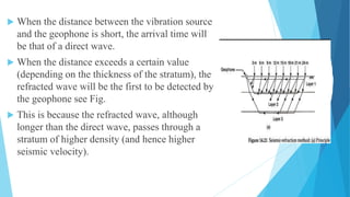
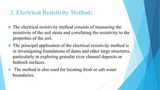
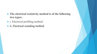
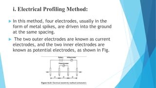
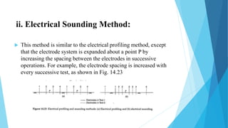
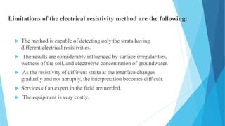
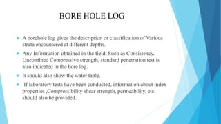
DR AMBEDKAR INSTITUTE OF TECHNOLOGY
SUBJECT NAME –FOUNDATION ENGINEERING
SUBJECT CODE-18CV63
STAFF INCHARGE-TEJASWINI B R
Geophysical Methods of Soil Exploration
 The following points highlight the two main
geophysical methods of soil exploration.
The methods are:
1. Seismic-Refraction Method
2. Electrical Resistivity Method.
1. Seismic-Refraction Method:
 The seismic-refraction method is based on the principle that
elastic shock waves travel at different velocities in different
materials.
 Shock waves are generated at a point on the ground surface, using
a sledge hammer.
 These waves travel deep into the ground and get refracted at the
interface of two different materials and to the ground surface.
 The time of arrival of these waves at different locations on the
ground surface are recorded by geophones, which pick up the
refracted waves. The geophones convert the ground vibrations
into electrical impulses and transmit them to a recording
apparatus.
 When the distance between the vibration source
and the geophone is short, the arrival time will
be that of a direct wave.
 When the distance exceeds a certain value
(depending on the thickness of the stratum), the
refracted wave will be the first to be detected by
the geophone see Fig.
 This is because the refracted wave, although
longer than the direct wave, passes through a
stratum of higher density (and hence higher
seismic velocity).
The seismic-refraction method is based on the
following assumptions:
i. The density, and hence the seismic velocity, of
successive layers of soil increases with depth.
ii. Each stratum of soil is homogeneous and
isotropic.
iii. The boundaries between strata are distinct
horizontal or inclined planes.
2. Electrical Resistivity Method:
 The electrical resistivity method consists of measuring the
resistivity of the soil strata and correlating the resistivity to the
properties of the soil.
 The principal application of the electrical resistivity method is
in investigating foundations of dams and other large structures,
particularly in exploring granular river channel deposits or
bedrock surfaces.
 The method is also used for locating fresh or salt water
boundaries.
 The electrical resistivity method is of the following
two types:
 i. Electrical profiling method.
 ii. Electrical sounding method.
i. Electrical Profiling Method:
 In this method, four electrodes, usually in the
form of metal spikes, are driven into the ground
at the same spacing.
 The two outer electrodes are known as current
electrodes, and the two inner electrodes are
known as potential electrodes, as shown in Fig.
ii. Electrical Sounding Method:
 This method is similar to the electrical profiling method, except
that the electrode system is expanded about a point P by
increasing the spacing between the electrodes in successive
operations. For example, the electrode spacing is increased with
every successive test, as shown in Fig. 14.23
Limitations of the electrical resistivity method are the following:
 The method is capable of detecting only the strata having
different electrical resistivities.
 The results are considerably influenced by surface irregularities,
wetness of the soil, and electrolyte concentration of groundwater.
 As the resistivity of different strata at the interface changes
gradually and not abruptly, the interpretation becomes difficult.
 Services of an expert in the field are needed.
 The equipment is very costly.
How to determine Number and Depths of Boreholes for
Geostructures?
• borehole numbers should be enough to find out soil-layer
variations at the construction site.
• If the location of loads is within the boundary of the structure,
then at least one borehole should be drilled at the position of the
heaviest load.
• Except in the case of very dense materials or bedrock, the
minimum depth of borehole is 6m.
• Drill a borehole at least 3m into bedrock.
• For dense, coarse-grained soil and very stiff clays, extend
boring depth up to a range of 5-6m to corroborate that soil
layer thickness is sufficient.
• Boreholes must penetrate very soft deposits or fills below
the proposed Geostructures.
• For compressible soils like clay, boring depth is the
greater of foundation width times a value between 1 and
3, or the depth at which the stress increment caused by
heaviest foundation load is smaller than 10%.
General guidelines for location and depth of bore holes
Boreholes are generally located at:
 The building corners
 The center of the site
 Where heavily loaded columns or machinery pads are
proposed.
 At least one boring should be taken to a deeper
stratum, probably up to the bedrock if practicable .
 Other borings may be taken at least to significant stress
level.
Spacing of Bore Holes – Codal Recommendations
According to IS 1892 (1979) Code of practice for subsurface
investigation:
 For a small building one bore hole or test pit at the center can
give necessary data.
 For a building covering not more than 4000 sq.m, one bore hole
or test pit at each corner and one at center is adequate.
 For a large project, the number will depend on its geological
features and variation of strata. Generally a grid of 50 m spacing
should be used with a combination of bore holes and sounding
tests.
Borehole Spacing- Guidelines
Depth of Investigation
The depth of investigation depends on
 The size and type of proposed structure
 Sequence of proposed strata.
 The depths of boreholes should cover the zone of soil that will be
affected by the structural loads. There is no fixed rule to follow.
In most cases, the depths of boreholes are governed by experience
based on the geological character of the ground, the importance
of the structure, the structural loads, and the availability of
equipment
Guidelines for depth of investigation
 At least one boring should be taken to deeper stratum,
probably up to the bedrock if practicable.
 Borings should penetrate at least 3 m into rock.
 Other borings may be taken at least to significant stress
level.
 In compressible soils such as clays, the borings should
penetrate at least between I and 3 times the width of the
proposed foundation or until the stress increment due to
the heaviest foundation load is less than 10%,
whichever is greater.
 In very stiff clays, borings should penetrate 5-7 m to
prove that the thickness of the stratum is adequate.
 Borings must penetrate below any fills or very soft
deposits below the proposed structure.
 The minimum depth of boreholes should be 6 m unless
bedrock or very dense material is encountered.
BORE HOLE LOG
 A borehole log gives the description or classification of Various
strata encountered at different depths.
 Any Information obtained in the field, Such as Consistency.
Unconfined Compressive strength, standard penetration test is
also indicated in the bore log.
 It should also show the water table.
 If laboratory tests have been conducted, information about index
properties ,Compressibility shear strength, permeability, etc.
should also be provided.
A soil exploration report generally consist of following:
 Introduction, which gives the scope of the investigation.
 Description of the proposed structure, the location and
geological conditions-at the site
 Details of field exploration programme, indicating, the
number of borings, their location and depths.
 Details of methods of exploration
 General description of the sub-soil conditions as
obtained from in-situ tests. Such as standard penetration
test, cone test.
 Details of the laboratory test conducted on the soil samples
obtained and the results obtained.
 Depth of the ground water table and changes in water levels
 Discussion of the results.
 Recommendation about the allowable bearing pressure, the type
of foundation.
Conclusions
 The Main findings of Investigations should be clearly stated.
 It should be brief but should mention the salient points
 limitations of the investigations should also be briefly stated
THANK YOU

foundation engg group activity.pptx

  • 1.
    DR AMBEDKAR INSTITUTEOF TECHNOLOGY SUBJECT NAME –FOUNDATION ENGINEERING SUBJECT CODE-18CV63 STAFF INCHARGE-TEJASWINI B R
  • 2.
    Geophysical Methods ofSoil Exploration  The following points highlight the two main geophysical methods of soil exploration. The methods are: 1. Seismic-Refraction Method 2. Electrical Resistivity Method.
  • 3.
    1. Seismic-Refraction Method: The seismic-refraction method is based on the principle that elastic shock waves travel at different velocities in different materials.  Shock waves are generated at a point on the ground surface, using a sledge hammer.  These waves travel deep into the ground and get refracted at the interface of two different materials and to the ground surface.  The time of arrival of these waves at different locations on the ground surface are recorded by geophones, which pick up the refracted waves. The geophones convert the ground vibrations into electrical impulses and transmit them to a recording apparatus.
  • 4.
     When thedistance between the vibration source and the geophone is short, the arrival time will be that of a direct wave.  When the distance exceeds a certain value (depending on the thickness of the stratum), the refracted wave will be the first to be detected by the geophone see Fig.  This is because the refracted wave, although longer than the direct wave, passes through a stratum of higher density (and hence higher seismic velocity).
  • 5.
    The seismic-refraction methodis based on the following assumptions: i. The density, and hence the seismic velocity, of successive layers of soil increases with depth. ii. Each stratum of soil is homogeneous and isotropic. iii. The boundaries between strata are distinct horizontal or inclined planes.
  • 6.
    2. Electrical ResistivityMethod:  The electrical resistivity method consists of measuring the resistivity of the soil strata and correlating the resistivity to the properties of the soil.  The principal application of the electrical resistivity method is in investigating foundations of dams and other large structures, particularly in exploring granular river channel deposits or bedrock surfaces.  The method is also used for locating fresh or salt water boundaries.
  • 7.
     The electricalresistivity method is of the following two types:  i. Electrical profiling method.  ii. Electrical sounding method.
  • 8.
    i. Electrical ProfilingMethod:  In this method, four electrodes, usually in the form of metal spikes, are driven into the ground at the same spacing.  The two outer electrodes are known as current electrodes, and the two inner electrodes are known as potential electrodes, as shown in Fig.
  • 9.
    ii. Electrical SoundingMethod:  This method is similar to the electrical profiling method, except that the electrode system is expanded about a point P by increasing the spacing between the electrodes in successive operations. For example, the electrode spacing is increased with every successive test, as shown in Fig. 14.23
  • 10.
    Limitations of theelectrical resistivity method are the following:  The method is capable of detecting only the strata having different electrical resistivities.  The results are considerably influenced by surface irregularities, wetness of the soil, and electrolyte concentration of groundwater.  As the resistivity of different strata at the interface changes gradually and not abruptly, the interpretation becomes difficult.  Services of an expert in the field are needed.  The equipment is very costly.
  • 11.
    How to determineNumber and Depths of Boreholes for Geostructures? • borehole numbers should be enough to find out soil-layer variations at the construction site. • If the location of loads is within the boundary of the structure, then at least one borehole should be drilled at the position of the heaviest load. • Except in the case of very dense materials or bedrock, the minimum depth of borehole is 6m. • Drill a borehole at least 3m into bedrock.
  • 12.
    • For dense,coarse-grained soil and very stiff clays, extend boring depth up to a range of 5-6m to corroborate that soil layer thickness is sufficient. • Boreholes must penetrate very soft deposits or fills below the proposed Geostructures. • For compressible soils like clay, boring depth is the greater of foundation width times a value between 1 and 3, or the depth at which the stress increment caused by heaviest foundation load is smaller than 10%.
  • 13.
    General guidelines forlocation and depth of bore holes Boreholes are generally located at:  The building corners  The center of the site  Where heavily loaded columns or machinery pads are proposed.  At least one boring should be taken to a deeper stratum, probably up to the bedrock if practicable .  Other borings may be taken at least to significant stress level.
  • 14.
    Spacing of BoreHoles – Codal Recommendations According to IS 1892 (1979) Code of practice for subsurface investigation:  For a small building one bore hole or test pit at the center can give necessary data.  For a building covering not more than 4000 sq.m, one bore hole or test pit at each corner and one at center is adequate.  For a large project, the number will depend on its geological features and variation of strata. Generally a grid of 50 m spacing should be used with a combination of bore holes and sounding tests.
  • 15.
  • 16.
    Depth of Investigation Thedepth of investigation depends on  The size and type of proposed structure  Sequence of proposed strata.  The depths of boreholes should cover the zone of soil that will be affected by the structural loads. There is no fixed rule to follow. In most cases, the depths of boreholes are governed by experience based on the geological character of the ground, the importance of the structure, the structural loads, and the availability of equipment
  • 17.
    Guidelines for depthof investigation  At least one boring should be taken to deeper stratum, probably up to the bedrock if practicable.  Borings should penetrate at least 3 m into rock.  Other borings may be taken at least to significant stress level.  In compressible soils such as clays, the borings should penetrate at least between I and 3 times the width of the proposed foundation or until the stress increment due to the heaviest foundation load is less than 10%, whichever is greater.
  • 18.
     In verystiff clays, borings should penetrate 5-7 m to prove that the thickness of the stratum is adequate.  Borings must penetrate below any fills or very soft deposits below the proposed structure.  The minimum depth of boreholes should be 6 m unless bedrock or very dense material is encountered.
  • 19.
    BORE HOLE LOG A borehole log gives the description or classification of Various strata encountered at different depths.  Any Information obtained in the field, Such as Consistency. Unconfined Compressive strength, standard penetration test is also indicated in the bore log.  It should also show the water table.  If laboratory tests have been conducted, information about index properties ,Compressibility shear strength, permeability, etc. should also be provided.
  • 21.
    A soil explorationreport generally consist of following:  Introduction, which gives the scope of the investigation.  Description of the proposed structure, the location and geological conditions-at the site  Details of field exploration programme, indicating, the number of borings, their location and depths.  Details of methods of exploration  General description of the sub-soil conditions as obtained from in-situ tests. Such as standard penetration test, cone test.
  • 22.
     Details ofthe laboratory test conducted on the soil samples obtained and the results obtained.  Depth of the ground water table and changes in water levels  Discussion of the results.  Recommendation about the allowable bearing pressure, the type of foundation. Conclusions  The Main findings of Investigations should be clearly stated.  It should be brief but should mention the salient points  limitations of the investigations should also be briefly stated
  • 23.