
Recommended
Recommended
More Related Content
Similar to Dighomi Meadows Stakeholder 3rd Meeting 2024.04.11
Similar to Dighomi Meadows Stakeholder 3rd Meeting 2024.04.11 (20)
Recently uploaded
Recently uploaded (20)
Dighomi Meadows Stakeholder 3rd Meeting 2024.04.11
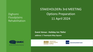
- 1. Dighomi Floodplains Rehabilitation STAKEHOLDERs 3rd MEETING Options Preparation 11 April 2024 Event Venue : Holiday Inn Tbilisi address: 1 Twentysix May Square
- 2. Dighomi Floodplains Rehabilitation PROGRAMME 09:30 Registration and welcoming coffee 09:45 Introduction to the project – Tbilisi Development Fund 09:55 Introduction to the scope of the project and programme – SMEC Team Leader 1015 Introduction to the SMEC Study Team 10:20 The study area 10:30 Baseline Studies, the Existing Situation Ecology Hydrology Topography Environment Planning Context 11:15 Coffee Break 11:45 Goals and Objectives of the Study 12:00 Discussion of the conclusions of the Baseline Analysis Planning Environment and Rehabilitation Next Steps 13:00 Workshop closes
- 3. Dighomi Floodplains Rehabilitation SCOPE OF THE PROJECT • Contract Name: Development of Strategy for Dighomi • Client: Tblisi Development Fund • Funding: Asian Development Bank Floodplain Rehabilitation • Name of the Consultant: SMEC International Pty Ltd (Australia) (Lead) in association with SMEC Georgia LLC (Georgia) (sub-consultant) • Office Location 15 Kipshidze, Tbilisi, Georgia • Date of Award 1st of June 2023 • Date of Commencement 8th of June 2023 • Contract Period 12 months • Contract End 8th of June 2024
- 4. Dighomi Floodplains Rehabilitation THE STUDY TEAM Team Leader Jim Jessamine Deputy Team Leader Giorgi Giorgadze Urban Planner Joseph Salukvadze Biodiversity Expert Arthur Mitchell Environmental Expert Lika Bubashvili Geologist Guram Iashvili Forestry Expert Niko Karsimashvili Hydrologist Nika Tsitelashvili GIS Expert Tamar Tsamalashvili Financial Analyst Sophio Gelashvili Tourism Expert Eka Burdiladze Landscape Planner Simon Bell SMEC Coordinator Giorgi Tsurtsumia
- 5. Dighomi Floodplains Rehabilitation INTRODUCTION TO THE PROJECT • Since November 2016, the ADB has supported the Government of Georgia to mainstream an integrated and participatory approach to urban development by improving strategic planning of selected urban area clusters to achieve a more balanced regional development by preparing Integrated Urban Action Plans. • Building on this, the government has prioritized crucial urban investments for ADB to take forward through feasibility studies and safeguards due diligence. Georgia has received financing from ADB in the form of a loan towards the cost of the Liveable Cities Investment Program (LCIP) to improve urban and tourism infrastructure and services across Georgia and Tbilisi. • TDF, with support from ADB, initiated the process of development of the Dighomi Floodplain strategy that will be long-term view of and strategic plan for restoration of the Dighomi floodplain, which needs to be aligned to LCIP and linked to subprojects implemented under the LCIP. • The strategic plan shall include short-, medium- and long-term development concepts. The core principle of the strategy shall be environment protection and preservation of unique characteristics of the riparian forest Role of Asian Development Bank and name of the project
- 6. Dighomi Floodplains Rehabilitation THE VISION The overarching vision of the project is to Rehabilitate the riverside areas of the Mtkvari River, the Dighomi Floodplains, as: • An integrated recreational open space; • A potential tourism resource; • A sustainable and biodiverse natural place. vision of the project
- 7. Dighomi Floodplains Rehabilitation Anticipated Outputs of the Study • Since November 2016, the Asian Development Bank (ADB) has supported the Government of Georgia to mainstream an integrated and participatory approach to urban development by improving strategic planning of selected urban area. INCEPTION REPORT BASELINE ANALYSIS REPORT OPTIONS GENERATION AND EVALUATION DRAFT FINAL REPORT FINAL REPORT ACTION PLAN LONG TERM PLAN MEDIUM TERM PLAN STAKEHOLDER MEETING STAKEHOLDER MEETING STAKEHOLDER MEETING strategic planning of selected urban area
- 8. Dighomi Floodplains Rehabilitation STUDY AREA and TBILISI CITY MASTER PLAN Functional layers from study area and Tbilisi Land Use Masterplan
- 9. Dighomi Floodplains Rehabilitation OPTIONS GENERAL The Terms of Reference for the assignment stipulate that the Consultant shall prepare ‘Problem statement and assessing solution statement alternatives’. This section describes the formulation of alternatives, or options, for the rehabilitation strategy and describe how these options are assessed. This process involves reference to our earlier Interim Report, Baseline Analysis, and consultation with all stakeholder segments to ensure a wide range of support for the identified preferred option. It is important that strategic proposals for the rehabilitation of the study area are based on a set of ultimate desired outcomes which policy and investment is intended to achieve. We have therefore defined a high level future vision for the Dighomi Floodplains, consistent with The Tbilisi City Master Plan 2019 and the Asian Development Bank’s Liveable Cities Program, followed by a set of high-level (cross-sector) strategic objectives and a set of more specific operational objectives.
- 10. Dighomi Floodplains Rehabilitation OPTIONS EVALUATION CRITERIA We have identified a total of six evaluation criteria against which to measure the performance of options, they are. Ease of Implementation. Land ownership issues and compliance with Tbilisi City Master Plan will be taken into consideration along with Cost. Broad orders of construction costs are identified for each of the proposed options. Alignment with ADB Liveable Cities Objectives. Enhancing urban planning and instituting institutional reforms. Social Gain. We examine options to broadly determine the levels of social gain accruing to each option. Factors that will be considered include access to open space, and the provision of community facilities. Economic Gain. We will broadly examine the order of economic gain associated with each option by determining the job creation and revenue generation potential of each option. Sustainability and Biodiversity. A crucial criteria. We will Examine the long-term sustainability of each option together with its potential to support and enhance the biodiversity of the Dighomi Floodplains.
- 11. Dighomi Floodplains Rehabilitation EVALUATION Options are scored on a scale of 1 to 4 against individual evaluation criteria with 1 being ‘poor’ and 4 being excellent. These scores are then summarised for comparison purposes in a summary table where the highest total score indicates the most preferred option. As is often the case in such exercises strongly performing options may be combined to form a hybrid option which harvest the best features of other options.
- 12. Dighomi Floodplains Rehabilitation OPTIONS FORMULATION 1 In considering the formulation of options for the rehabilitation of the study area we have identified a range of core criteria which will be applied to the construction of options. These criteria, which are draw from the Baseline Analysis, are set out below in broadly descending order of importance are. 1. Site Extents. i. Municipal Land Only. This option would be developed exclusively on land in the ownership of TCH and would be the simplest to implement as it would require the approval of a single authority. ii. Municipal and State Lands. In addition to lands under the ownership of TCH this option would incorporate state owned lands across the study area. While all land would be in ‘public ownership’ this option would need to undergo the more complex process of securing consents across a wide range of public bodies and ministries, a process which would be perhaps difficult to achieve in the short term. iii. Municipal and State Lands with limited Private Sector Lands. Options under this criteria will in addition to examining the use of municipal and state lands examine the limited use of private lands through the mechanism of surrender and development content gain. Such mechanisms involved the surrender of portions of private lands for specific purposes, such as the construction of access or green linkages. Development content lost through this process is then transferred, by negotiation, to the balance of the private sector landholding.
- 13. Dighomi Floodplains Rehabilitation OPTIONS FORMULATION 2 1. Biodiversity and Sustainability. The preservation and enhancement of the study area’s biodiversity is a core requirement of the rehabilitation strategy. In pusuing this objective we will examine three broad approaches, namely. i. No areas as natural reserves. To leave the area in its present condition, albeit with the addition of the Dighomi HPP and encourage natural processes to reforest the site. ii. Critical areas as natural reserves. To identify specific areas such as the Emerald Site, riverbank and lakes as high value natural reserve areas. iii.All areas as natural reserves. To examine the possibility of declaring the whole area to be a protected natural reserve, possible under the status of protect forest area.
- 14. Dighomi Floodplains Rehabilitation OPTIONS FORMULATION 3 1. Landforming. i. No land forming. site to be left in its present condition with any illegal or unauthorised structures cleared from the site. ii. Selected areas to be remodelled. The selective remodelling of fill areas to stabilise slopes, create riverside areas for planting and prepare plateau areas for rehabilitation by regrading. iii. All fill to be removed. We will examine the implications and costs of removing all fill materials which have been deposited over the site and returning the floodplains, in as much as is possible, to their original state. This will also involve the need to identify new sites for the disposal of inert waste materials. 2. Lakes and Borrow Pits. Leave in present condition. In this option we will examine the implications of leaving the borrow pits in their present configuration i. Reconfiguration. We will examine the possibility of configuring borrow pits into larger lakes, and possibly creating new island areas within those lakes. ii. Fill in. Finally, we will look into the possibility of filling in the borrow pits to restore the area landscape to its original condition.
- 15. Dighomi Floodplains Rehabilitation OPTIONS FORMULATION 4 1. Access. The Key Issues section of the Interim Report identified access to the floodplains as a major issue. At present access to the area is limited and difficult. We will examine the implications of amending access arrangements through three scenarios, namely. i. No access improvements. To leave access arrangements t othe area in their present configuration and condition. ii. Local access improvements. To improve access to local areas on both the left and right banks. In particular to improve access to both the Olympic Village and Tbilisi Mall areas. iii. City and hinterland access improvements. In addition to improving local access to examine linkages to the national parks, city centre and upstream river areas through the development in the longer term of strategic trekking and cycle routes. 2. End Use Planning. Under the approved 2019 Tbilisi City Master Plan a range of zoning proposals are applied to the study area. Under this criteria we will examine the implications of these proposals and what specific facilities should be provided across the study area. The basic variations that will be considered are. i. Low intensity. Reflecting the development of the area primarily as a nature reserve ii. Mixed development. Reflecting the zoning of the area into both low and high intensity areas. iii. High intensity. Reflecting the development of the area as an intensively used urban park.
- 20. Dighomi Floodplains Rehabilitation Landscape Assessment UNIT R2, Sub-unit D Main features: This area is the slope of the floodplain edge rising behind the abandoned university building territory. It is generally separated from the residential area by a public road but there have been some encroachments by several houses. It comprises a steep slope vegetated, with shrubs, trees and grass. It forms a green corridor and represents the original vegetation, although modified over time. Houses and gardens occupy some parts, especially at the northern end. Ownership status is uncertain. Opportunities and constraints: As the area is already wooded, close to residential areas and steep, there are no opportunities to develop it. The main opportunity is to reinforce the vegetation and to manage it to provide a strong edge to the rest of the project area and an important green corridor. The boundary between public and private land needs to be confirmed and identified on the ground to reduce encroachment Recommendation: There are opportunities for the basic development strategy but to protect the ecology any further intensification should be limited. Basic strategy: Establishing a more secure boundary, preventing encroachment and restoring and managing the existing vegetation.
- 21. Dighomi Floodplains Rehabilitation Options Key Determinants Consolidate borrow pits Local access link Municipal park Otter Island eco eco SERVICE CENTRE
- 22. Dighomi Floodplains Rehabilitation OPTION HIGH INTENSITY Private land surrender to secure links Pedestrian link to National park Private development Extent of municipal and state lands Pedestrian and cycle link to city cente Municipal park Tbilisi Mall HPP Olympic Village Fill in borrow pits Private development eco eco urban park Eco park Otter island
- 23. Dighomi Floodplains Rehabilitation Determine Outline Costs Outline Costs, Key Elements • Site Clearance • Landforming and regrading • Soft landscaping • Security fencing and barriers • Footpaths and cycleways • Service buildings • Professional fees • Contingencies
- 24. Dighomi Floodplains Rehabilitation OPTIONS EVALUATION FORM Criteria Ease of Implementation Cost Alignment with ADB LcP Social gain Economic gain Sustainability and Biodiversity Score Notes Land Parcelling Municipal Land Municipal and State Land Municipal, State and Private Biodiversity/Sustainability No Reserves Critical Reserves All Reserve Landforming No Landforming Landforming Remove Fill Lakes and Borrow Pits Leave as is Consolidate Fill Access No improvements Local access links
- 25. Dighomi Floodplains Rehabilitation Determine Phasing Overarching consideration: it will take around 10 yeas to establish an initial tree canopy on site PHASE 1 2025-2029 PHASE 2 2030-34 PHASE 3 2035-2039 • Prioritise use of municipal lands • Where possible incorporate state lands • Negotiate private land swaps for strategic links