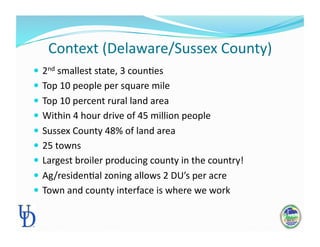
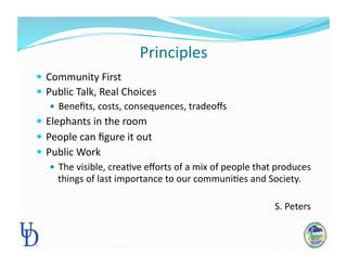
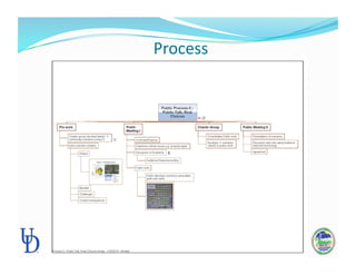
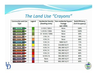
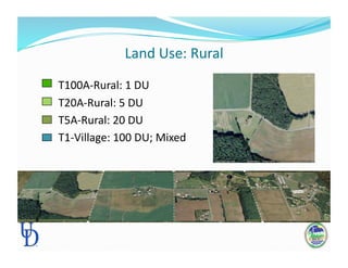
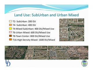
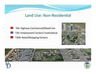
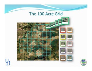
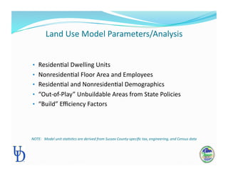
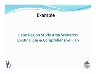
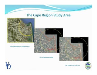
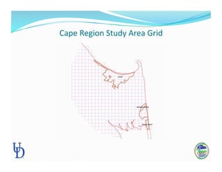
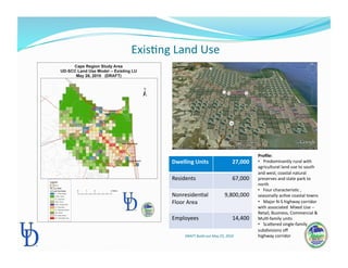
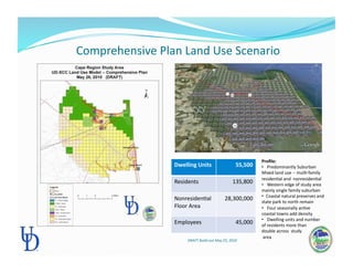
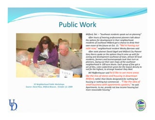
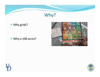
University
of
Delaware
Team

Bill
McGowan,
Ed.D,
County
Agent,
Community
Development


Carol
Bason,
Program
Manager,
CommunityViz®

Richard
Kautz,
Land
Use
Planner

Chuck
Donley
–
Donley
Associates

Context
(Delaware/Sussex
County)

 2nd
smallest
state,
3
counPes

 Top
10
people
per
square
mile

 Top
10
percent
rural
land
area

 Within
4
hour
drive
of
45
million
people

 Sussex
County
48%
of
land
area

 25
towns

 Largest
broiler
producing
county
in
the
country!


 Ag/residenPal
zoning
allows
2
DU’s
per
acre

 Town
and
county
interface
is
where
we
work

Principles

 Community
First

 Public
Talk,
Real
Choices

 Benefits,
costs,
consequences,
tradeoffs

 Elephants
in
the
room

 People
can
figure
it
out

 Public
Work

 The
visible,
creaPve
efforts
of
a
mix
of
people
that
produces

things
of
last
importance
to
our
communiPes
and
Society.


S.
Peters

Process

Partners

 Office
of
State
Planning
CoordinaPon

 Local
Government

 County
Government

 Community

The
Land
Use
“Crayons”

Land
Use:
Rural


T100A‐Rural:
1
DU


T20A‐Rural:
5
DU


T5A‐Rural:
20
DU


T1‐Village:
100
DU;
Mixed

Land
Use:
SubUrban
and
Urban
Mixed


T2‐
SubUrban:
200
DU


T4‐
SubUrban:
400
DU


T4‐Mixed
SubUrban:
400
DU/Mixed
Use


T6‐Urban
Mixed:
600
DU/Mixed
Use


T8‐Town
Center:
800
DU/Mixed
Use


T16‐High
Density
Mixed:
1600
DU/Mixed

Land
Use:
Non‐ResidenPal


TM:
Highway
Commercial/Mixed
Use


T30:
Employment
Centers/
InsPtuPonal


T200:
Retail/Shopping
Centers

The
100
Acre
Grid

Land
Use
Model
Parameters/Analysis

•  ResidenPal
Dwelling
Units

•  NonresidenPal
Floor
Area
and
Employees

•  ResidenPal
and
NonresidenPal
Demographics

•  “Out‐of‐Play”
Unbuildable
Areas
from
State
Policies


•  “Build”
Efficiency
Factors


NOTE:


Model
unit
sta:s:cs
are
derived
from
Sussex
County‐specific
tax,
engineering,
and
Census
data

Cape
Region
Study
Area
Scenarios


ExisPng
Use
&
Comprehensive
Plan

Example

The
Cape
Region
Study
Area

Demo
Boundary
on
Google
Earth

The
GIS
RepresentaPon

The
100A
Grid
ExtracPon

Cape
Region
Study
Area
Grid


ExisPng
Land
Use

Dwelling
Units
 27,000

Residents
 67,000

NonresidenPal


Floor
Area

9,800,000

Employees
 14,400

Profile:

• 

Predominantly
rural
with


agricultural
land
use
to
south

and
west;
coastal
natural

preserves
and
state
park
to

north

• 

Four
characterisPc
,


seasonally
acPve
coastal
towns

• 

Major
N‐S
highway
corridor

with
associated

Mixed
Use
‐‐

Retail,
Business,
Commercial
&

MulP‐family
units

• 

Scanered
single‐family

subdivisions
off


highway
corridor
DRAFT
Build‐out
May
25,
2010


Comprehensive
Plan
Land
Use
Scenario

Dwelling
Units
 55,500

Residents
 135,800

NonresidenPal

Floor
Area

28,300,000

Employees
 45,000

Profile:

• 

Predominantly
Suburban


Mixed
land
use
‐‐
mulP‐family

residenPal
and

nonresidenPal


• 

Western
edge
of
study
area

mainly
single
family
suburban

• 
Coastal
natural
preserves
and

state
park
to
north
remain


• 

Four
seasonally
acPve

coastal
towns
add
density

• 

Dwelling
units
and
number

of
residents
more
than


double
across

study


area

DRAFT
Build‐out
May
25,
2010

Benefits
of
the
UD‐SCC
Land
Use
Model

  Stakeholder
interests

visualized
and
analyzed

  Public

deliberates
and
makes
land
use
choices

  “On‐the‐fly”
impact
analysis

idenPfies
consequences

  “What‐if”
process

provides
implementaPon
opPons

  IteraPve
tradeoff
&
visualizaPon
process

leads
to
consensus

  Ready‐to‐go
Model

at
State,
Local,
and
Regional
Planning

Challenges

 Visual

 Heart
&
Soul
Versus
Hammer
&
Tongs

 IniPal
setup

Public
Work

Milford,
Del.
–
“Southeast
residents
speak
out
on
planning”


ARer
hours
of
hearing
professional
planners
talk
about

the
op:ons
for
development
in
their
neighborhood,

residents
of
southeast
Milford
got
a
chance
to
draw
their

own
vision
of
the
future
on
Oct.
15.
“We’re
having
our

vote
now,”
neighborhood
resident
Wesley
Barrows
said.


ARer
state
planner
David
Edgell
and
Milford
City
Planner

Gary
Norris
spoke
on
the
op:ons
they’d
come
up
with
for

zoning
and
development
southeast
of
town,
almost
50
local

residents,
farmers
and
businesspeople
took
their
turn
as

planners,
laying
out
their
own
maps
of
the
southeast

neighborhood
in
100‐acre
blocks.
Each
group
of
five
got
a

set
of
:les,
color‐coded
from
green
for
the
lowest
density
to

red
for
the
highest,
to
arrange
however
they
liked.


Bill
Pfaffenhauser
said
he’d
like
to
see
more
areas

like
the
mix
of
stores
and
housing
in
downtown

Milford,
rather
than
blocks
designated
for
nothing
but

housing
or
nothing
but
commercial.

.
“I
like
the
idea
of

small
business
with
apartments
upstairs,”
he
said.


Apartments,
to
me,
provide
not
low‐income
housing
but

more
reasonable
housing.”

SE
Neighborhood
Public
Workshops


Source:
David
Ross,
Milford
Beacon,

October
22,
2009

Why?

 Why
grids?

 Why
a
100
acres?

Milton
Bradley
‐
1962

My
Wayward
Youth….


CM10 Visualizing Better Futures Bill McGowan