Newsletter Lika Electronic febbraio 2019 in italianoLika Electronic
IF09, splitter e convertitore per segnali encoder. IF09 è un dispositivo versatile ed economico che duplica i segnali AB0 o AB0 /AB0 provenienti da un encoder incrementale di livello TTL / RS-422 o HTL e li restituisce all’elettronica a valle tramite due uscite TTL / HTL configurabili individualmente.
This document discusses Adobe's signature preview mode and formal representation. It is a copyrighted document from Adobe Systems Incorporated from 2004-2010 with rights reserved. The document was last updated on September 21, 2010.
This advertisement is for commercial retail shops located on NH-8 in Baani Center Point. The shops are 451 square feet or larger and face a busy highway for high visibility. Amenities include a multiplex and food court nearby. The advertised rate is Rs. 11,750 per square foot with low maintenance fees. Interested parties should contact Ruchika at the listed phone numbers for more information.
The document discusses Open History Map, which aims to create tools to teach history using modern web GIS tools. It notes challenges representing history with detail, depth, and structure. Open History Map created a map and data index to contextualize historical sources in time and space. It discusses representing changes over time from nature, mankind, and ephemeral data like photos. The future may include a public history toolkit and updating Wikidata and other databases with digital humanities data.
- OpenHistoryMap aims to create a toolchain and tools for teaching history using modern web-GIS tools. It allows representation of historical data with varying levels of detail, sources, and time periods.
- The software uses open source tools like Python, PostGIS, and Docker. Data is stored in Postgres and rendered on a tileserver for viewing maps on openhistorymap.org.
- Tools are being developed for tasks like digitizing old maps, reconciling data from different sources, and creating visualizations for educators. Future goals include integrating with Wikipedia and adding time series and 3D modeling capabilities.
The document traces the history of computing from ancient times to the present day. It discusses important figures and inventions such as Charles Babbage and Ada Lovelace, Alan Turing, the development of programmable computers at universities in the 1940s, the creation of Microsoft and Apple in the 1970s, and the rise of personal computing and the Internet. The summary highlights some of the key people and technologies that have shaped the evolution of the field over time.
This document discusses defining descriptors to simplify analysis and enable composition of features for cultural heritage applications. It presents the "divide and conquer" approach of separating the problem into maps, content and menus. Descriptors are defined for the map component, including a geocontext JSON sample defining layers and data sources to visualize geographic information. A static content JSON sample is also provided. Finally, it demonstrates existing applications and discusses installation/use of the open source front-end framework.
GEOCONTEXT AND CHCONTEXT GEOGRAPHIC INFORMATION IN CULTURAL HERITAGEMarco Montanari
Internet presence and applications are central for modern museums and cultural institutions. Even more it is important to facilitate and standardize the user experience in order to create a standard quality level and, for the institutions, it is important to simplify configuration operations bound to the creation of the visualized elements and the explorations of the spaces. This demo covers both the technologies underneath the GeoContext tool and the CHContext visualization generator as well as the possible targets and applications.
The document discusses OpenHistoricalMap (OHM), a project that aims to create an open platform for participatory and public archaeology. It summarizes OHM's approach of digitizing archaeological data at different levels of detail and tracking interpretations over time. The technology behind OHM is based on OpenStreetMap and includes additions like a tiler for digitizing paper maps and a time travel toolbar. The goal is to make archaeological research and data openly accessible and traceable.
MN-MAP is an Angular module that simplifies interacting with geographical datasets and web services by wrapping common LeafletJS operations and plugins in a simple API. It addresses the complexity of defining Angular components and directives without pure JavaScript simplicity as well as interacting with asynchronous Angular architecture. The module is an Angular4+ wrapper for LeafletJS that is plugin-aware and exposes common mapping situations through a simple API.
The document discusses using standardized metadata and APIs to generate reusable UI components for designers. It proposes using Django Rest Framework metadata and a library called GrapesJS to automatically create common components like lists and detail views. This would allow developers to write code once and designers to modify the UI without additional coding. The speaker demonstrates a prototype that transforms DRF metadata into GrapesJS components to connect APIs and user interfaces more seamlessly.
This document discusses how big data is impacting tourism. It notes that data comes from tourists, attractions, hotels, and restaurants through sensors and online activities. This data is owned by both the government and private sector, but the private sector data is more integrated with user experiences. It also discusses challenges with scraping data from major travel sites which frequently change their structures. Potential applications of big data in tourism include analyzing user behaviors, automated storytelling for destinations, and tailoring experiences based on user profiles.
The document discusses OpenHistoryMap (OHM), a public archaeology and participatory GIS project. It addresses OHM's approach to digitizing archaeological data at different levels of detail, developing a research ontology to track interpretations, and reliability of source information. The document also outlines OHM's open-source technology stack built on OpenStreetMap and its custom additions like a tiler, time travel toolbar, and Archaeological Research Database to integrate archaeological research. Finally, it invites the audience to join the open-source OHM community.
Open Data e Trasparenza come punto di contatto fra cittadinanza e politica
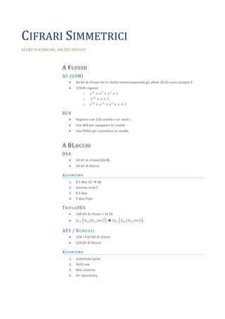
Cifrari simmetrici
1. CIFRARI SIMMETRICI
SEGRETO COMUNE , MEZZO RISCHIO
A F LUSSO
A5 (GSM)
64 bit di chiave ma in realtà misteriosamente gli ultimi 10 bit sono sempre 0
3 Shift-register
o 𝑥 19 + 𝑥 5 + 𝑥 2 + 1
o 𝑥 22 + 𝑥 + 1
o 𝑥 23 + 𝑥 15 + 𝑥 2 + 𝑥 + 1
RC4
Registro con 256 caselle e un seed L
Usa SKA per swappare le caselle
Usa PRGA per scambiare le caselle
A BL OCCHI
DSA
64 bit di chiave (56+8)
64 bit di blocco
ALGORITMO
1. 8 E-Box 32 48
2. Somma mod 2
3. 8 S-Box
4. P-Box fisso
T R I P L E DES
168 bit di chiave = 3x 56
𝐸 𝑘1 𝐷 𝑘2 𝐸 𝑘3 𝑚 𝐷 𝑘3 𝐸 𝑘2 𝐷 𝑘1 𝑚
AES / R I J N D A E L
128 + k32 bit di chiave
128 bit di blocco
ALGORITMO
1. Substitute bytes
2. Shift row
3. Mix columns
4. Arr dound key
2. M ODALITÀ DI CIFRATURA
CBC
Ogni blocco cifrato viene usato come IV del blocco successivo
CFB, OFB
Flusso autosincronizzante (con shift register)
CTR
Flusso sincrono (con contatore)