Presentación programa nacional de becas al exteriordanipedro20
El documento describe las becas Don Carlos Antonio López. Tiene como objetivo aumentar los niveles de generación y aplicación de conocimiento en áreas de ciencia y tecnología y mejorar la educación a través de becas para fortalecer la investigación, innovación y educación. Ofrece becas para maestrías y doctorados en universidades de alto ranking a nivel mundial en diversas áreas como ciencias, ingeniería, medicina, educación y más.
The document is a collection of photos and captions describing street children and those living in poverty in various locations around the world, primarily in Brazil. The photos were taken by different photographers and foundations working to help at-risk children and families living in poverty. The captions provide context about the hardships faced by those living in extreme poverty, especially children, in places like Brazil, India, the Philippines, and Rwanda.
This document features a collection of 35 smoke photographs from various photographers. Dry ice was used to create interesting smoke effects in bottles. Other techniques included using lightbulbs, incense, and Photoshop to shape smoke into artistic forms like waves, figures, and symmetrical patterns. Experimenting with the movement and shapes of smoke can produce unexpected and imaginative images.
Cia World Factbook Reference Map Middle Eastalanocu
This map shows the Middle East region, including countries such as Turkey, Syria, Iraq, Iran, Saudi Arabia, Yemen, Israel, and others. Key geographical features are labeled, such as the Black Sea, Caspian Sea, Persian Gulf, and Red Sea. Major cities throughout the region are also indicated on the map.
The central Balkan region document provides a map showing key cities and rivers in central Balkan countries. The map shows locations in Slovenia, Croatia, Serbia, Hungary, Romania, and Bosnia and Herzegovina. Major rivers depicted include the Drava, Tisza, Danube, Sava, and Mures. Cities labeled on the map include Zagreb, Osijek, Novi Sad, Szeged, Timisoara, and Arad.
Cia World Factbook Reference Map Time Zonesalanocu
This document outlines the standard time zones of the world. It shows the 24 time zones ranging from -12 to +14, along with place names and time differences noted within many of the zones. The time zones are centered on the 0 line which represents the Greenwich Meridian, with negative numbers to the west and positive to the east.
This document provides a map of Asia showing major geographic features and political boundaries. Key details shown on the map include major cities, islands, seas, mountain ranges, and borders between countries. The map extends from Europe in the west to the Pacific Ocean in the east and from the Arctic Ocean in the north to the Indian Ocean in the south. Country labels and capital cities are included to help identify the different nations.
Cia World Factbook Reference Map North Americaalanocu
1. The document is a map of North America that shows the physical features and political boundaries of the continent.
2. Major cities, bodies of water, and mountain ranges are labeled on the map, which spans from the Arctic Ocean in the north to Central America in the south.
3. Political boundaries include national borders between countries like the United States, Canada, Mexico, and smaller Central American countries.
This map shows the geographic locations of various islands and island groups in the Oceania region of the world, including:
- Major island countries like Australia, New Zealand, Indonesia, Philippines, Japan.
- Small island nations of the Pacific Ocean like Fiji, Tonga, Samoa, Tuvalu, Marshall Islands and others.
- Unincorporated territories of countries in the region labeled on the map.
Cia World Factbook Reference Map South Americaalanocu
The document is a map of South America that shows the countries, major cities, rivers, and seas. It displays political boundaries and place names for countries like Colombia, Venezuela, Guyana, Suriname, Brazil, and others. Major geographical features like the Andes Mountains, Amazon River, and Orinoco River are indicated on the map.
The Arctic region document provides a map showing key geographical features of the Arctic. It notes that the Kuril Islands were occupied by the Soviet Union in 1945 and are currently administered by Russia but claimed by Japan. Sakhalin Island faces similar territorial disputes between Russia and Japan.
This document provides an overview of the Singularity project, which aims to build a new operating system and software platform from scratch with a primary goal of dependability. The Singularity system uses software-isolated processes (SIPs) that provide information hiding, failure isolation, and strong interfaces to encapsulate application and system components. SIPs differ from conventional processes by being closed object and code spaces, communicating through typed channels, and having low overhead for creation and communication. The goal of the Singularity system is to demonstrate how new programming languages, compilers, and analysis tools can enable more robust and dependable software architectures.
Seeing O S Processes To Improve Dependability And Safetyalanocu
This document proposes and evaluates a sealed process architecture as an alternative to the traditional open process architecture used in most modern operating systems. The key aspects of a sealed process architecture are:
1. Code within a process cannot change once execution begins (fixed code invariant).
2. A process's state cannot be directly accessed by other processes (state isolation invariant).
3. All communication between processes is explicit, with sender and receiver control (explicit communication invariant).
4. The kernel API respects the above invariants and does not allow them to be subverted (closed API invariant).
The document describes an implementation of sealed processes in the Singularity operating system and presents preliminary benchmarks showing competitive performance compared to open
Language Support For Fast And Reliable Message Based Communication In S...alanocu
1. The document describes a communication system for the Singularity OS that uses message passing over channels as the sole means of inter-process communication.
2. Channels are bidirectional and consist of two endpoints that are statically typed. Channel contracts specify valid message types and sequences.
3. Safety is ensured through the use of a type-safe language and static verification that guarantees each block of shared memory is owned by only one thread at a time.
Cia World Factbook Reference Map United Statesalanocu
1. The document is a map of the United States showing state boundaries and capital cities.
2. Key features include the contiguous 48 states, Alaska, Hawaii, Washington D.C., and some surrounding international locations.
3. Labels indicate state names, capital cities, and major bodies of water or land features.
Cia World Factbook Reference Map Time Zonesalanocu
This document displays the standard time zones of the world, with longitude lines indicating the boundaries of each zone. The time zones range from -12 to +14 hours relative to Greenwich Mean Time. Major cities and political borders are labeled on the map to show how time zones correspond with geographic locations around the globe.
The document describes the Singularity project, which aims to redesign operating system architectures and software stacks to improve dependability and trustworthiness. The key architectural features of Singularity systems are software-isolated processes (SIPs) for isolation, contract-based channels for communication between SIPs, and manifest-based programs (MBPs) for verification of system properties. SIPs provide lightweight process isolation through type safety instead of hardware protection. Communication between SIPs occurs via channels defined by message contracts. MBPs specify the code and behavior of processes.
The "Google generation" not so hot at Googling, after allalanocu
A new UK report on the habits of the "Google Generation" finds that kids born since 1993 aren't quite the Internet super-sleuths they're sometimes made out to be.
This document provides instructions for assembling paper airplane models without images or diagrams. It lists the steps to glue identical parts together, attach the wings and fuselage, insert the tail parts, glue on the engines for the Fokker model, and attach the completed display. The models include a Douglas DC-3, Constellation, and Fokker 100.
1. The document provides assembly instructions for a cardboard skatepark model.
2. The skatepark model includes features like banks, quarterpipes, halfpipes, pyramids, stairs, slopes, and curbs.
3. The instructions explain how to cut out and assemble each part, starting with gluing the bottom pieces to cardboard and then assembling and attaching the other pieces like slopes and stairs to complete the skatepark.
Print the 12 pages with over 100 parts on thick (80 grams) paper and start cutting and glueing and make your own personal Bert. See the end result at http://www.bertsimons.nl/zenphoto/paperworks/clone/
This document provides information about Project Gutenberg, including its goals and operations. It discusses Project Gutenberg's mission to distribute one trillion free ebooks by 2001. It also provides contact information and guidelines for donating or communicating with Project Gutenberg.
Pictures made funny by the actions of people/objects in the backgroundalanocu
Pictures can be made humorous by the unintended or unexpected actions of people or objects in the background. These background elements take on an amusing quality when viewed in contrast to the main subject of the photo. Capturing such moments of serendipity can create funny pictures.
Pictures made funny by the actions of people/objects in the background
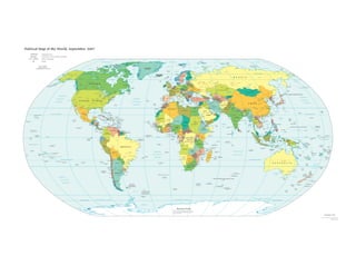
Cia World Factbook Reference Map Political World
1. Political Map of the World, September 2007
AUSTRALIA Independent state
Bermuda Dependency or area of special sovereignty
Sicily / AZORES Island / island group 150 120 90 60 30 0 30 60 90 120 150 180
Capital ARCTIC OCEAN Alert
ARCTIC OCEAN FRANZ JOSEF
ARCTIC OCEAN
LAND SEVERNAYA
ZEMLYA
Ellesmere
QUEEN ELIZABETH Island Qaanaaq (Thule) Longyearbyen
NEW SIBERIAN ISLANDS
Scale 1:35,000,000 Greenland Sea Svalbard NOVAYA Kara Sea
Banks
ISLANDS (NORWAY) ZEMLYA Laptev Sea
Robinson Projection Resolute Barents Sea
standard parallels 38°N and 38°S Beaufort Sea
Island
Pond Inlet Baffin Greenland East Siberian Sea Wrangel
Barrow Bay (DENMARK) Island
Victoria Tiksi
Island Baffin Jan Mayen Norwegian Pevek Chukchi
(NORWAY)
Island Noril'sk Sea
Sea Murmansk Cherskiy
Arctic Circle (66°33') Arctic Circle (66°33')
Nuuk
NORWAY White Sea
Nome U. S. Fairbanks Great
Bear Lake Iqaluit
(Godthåb) Denmark
ICELAND
SWEDEN Arkhangel'sk
Anadyr' Provideniya
Davis Strait Faroe
Reykjavík
Anchorage Great
Strait
Tórshavn
Islands
(DEN.) Gulf
of
FINLAND Lake
Ladoga Lake
R U S S I A Yakutsk
Whitehorse Bothnia Onega
60
Slave Lake Hudson Oslo Helsinki
Magadan 60
Tallinn Saint Petersburg
Bay Rockall
Stockholm
EST. Perm'
Gulf of Alaska Juneau Churchill
Kuujjuaq Labrador (U.K.) Baltic Yaroslavl'
Nizhniy Tyumen'
Bering Sea
Fort McMurray Sea Riga Izhevsk
Sea North DENMARK
LAT. Novgorod Yekaterinburg
Tomsk
Krasnoyarsk
Glasgow Moscow Kazan'
Prince
George
CANADA Happy Valley-
Belfast UNITED
Sea Copenhagen RUSSIA
LITH.
Vilnius
Minsk Ul'yanovsk Ufa
Chelyabinsk Omsk Novosibirsk Lake
Baikal
Sea of
DS Leeds Hamburg Okhotsk
SLAN Goose Bay Dublin Isle of Samara Barnaul
I Edmonton Man BELARUS
TIAN Saskatoon
Lake IRELAND (U.K.) KINGDOM Amsterdam Berlin Warsaw
. Irkutsk Petropavlovsk- U.S.
ALEU Orenburg Chita
Winnipeg Birmingham NETH. Lódz Homyel Voronezh Saratov Kamchatskiy
Island of Cologne Astana Sakhalin AL S
Calgary London Brussels POLAND Kyiv EUT ND
Winnipeg Newfoundland Lille GERMANY Prague Kraków Qaraghandy IAN ISLA
Celtic BELGIUM LUX. Frankfurt L'viv (Karaganda)
Vancouver Sea Guernsey(U.K.)
Jersey (U.K.) Luxembourg CZECH REP. UKRAINE Kharkiv Volgograd Khabarovsk
SLOVAKIA
Lake
Gulf of Paris Munich
LIECH.
Vienna Bratislava
MOLDOVA Donets'k KAZAKHSTAN Ulaanbaatar KURIL
St. Lawrence AUSTRIA Budapest Rostov
Seattle Lake Québec FRANCE Chisinau Atyraü Lake Balkhash ISLANDS
Superior Bern SLOVENIA HUNGARY Odesa Astrakhan'